Regional overview
The Dunhuang–Aksay western Qilian region is the dry western end of the Nan Shan / Qilian mountain system where the Hexi Corridor, Gobi desert, dune fields, yardang badlands, Danghe drainage and high glaciated ranges meet. The walking character is very different from wetter Chinese mountain regions: many practical visitor routes are short desert-edge or scenic-area walks, while the higher Qilian objectives are remote, vehicle-dependent and poorly documented in public route files.
The main hiking bases are Dunhuang, Subei, Aksay and occasional high-road access towards the Dangjinshan and western Qilian passes. Dunhuang gives the best public access to managed walks at Mingsha Mountain, Crescent Spring, Sanwei Mountain and Yardang National Geopark. The higher western Qilian side, including the Touming Mengke / Laohugou No. 12 glacier area and the upper Danghe / Yanchiwan landscapes, is much more sensitive: access, reserve zoning, road conditions and local permissions need current local confirmation.
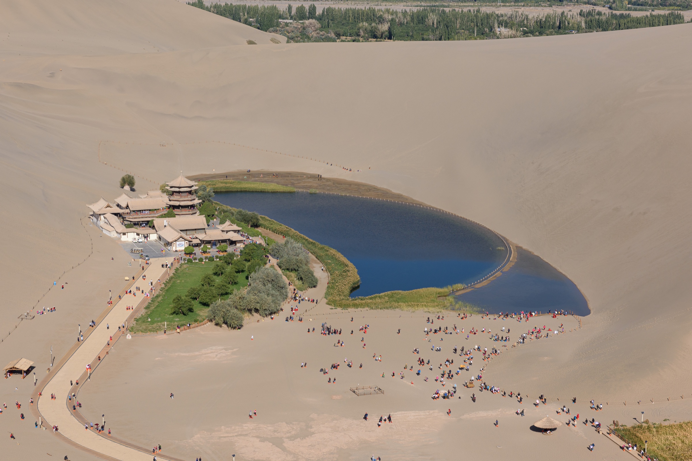
The usual walking season for the desert-edge routes is spring and autumn. Summer can be very hot in Dunhuang and the Gobi, while high western Qilian routes can still have snow, cold wind and storm risk. Winter brings cold, ice and short days. Water scarcity, sun exposure, sandstorms, long rescue distances and unclear protected-area rules are the main safety issues. The cover image above shows Crescent Lake from the Singing Sand Dunes — the canonical desert-edge view that opens Hike 1.
For adjacent and complementary sub-regions, see the Altyn Tagh in Xinjiang–Qinghai–Gansu (the next range south across the basin), the Eastern Kunlun / Golmud–Qaidam corridor (the high Qinghai plateau interior), and the Liupan Mountains in Ningxia–Gansu (the wetter eastern Gansu uplands).
Selection rationale
These five hikes balance the best-known public Dunhuang landscape walk, one historical ridge / cave-facing walk, one high-Qilian glacier-view candidate, one internationally recognised yardang geopark walk, and one Danghe gorge cultural route. Route evidence is weak outside the managed tourist sites. No official reusable GPX/KML files are currently available; most route entries are candidate lines only.
Summary table
| # | Hike | Country | Route type | Distance | Max elevation | Difficulty |
|---|---|---|---|---|---|---|
| 1 | Mingsha Mountain and Crescent Spring dune ridge circuit | China | Loop / out-and-back on dunes | ~3–6 km | 1,715 m (Mingsha summit) | Moderate (heat / sand) |
| 2 | Sanwei Mountain and Mogao-facing ridge walk | China | Out-and-back / short traverse | ~3–8 km | Unresolved | Moderate |
| 3 | Touming Mengke / Laohugou No. 12 Glacier viewpoint approach | China | Out-and-back candidate | Unresolved | Unresolved | Hard / remote |
| 4 | Dunhuang Yardang National Geopark viewpoint walks | China | Shuttle-assisted viewpoint walks | ~2–5 km | Unresolved | Easy–moderate |
| 5 | Five Temple Caves / Danghe gorge cultural walk | China | Out-and-back / site walk | ~1–4 km | Unresolved | Easy–moderate |
1. Mingsha Mountain and Crescent Spring dune ridge circuit
Snapshot
Itinerary
From the scenic-area entrance, walk to Crescent Spring, then climb one of the authorised dune routes above the lake for the classic high view across the oasis, sand ridges and Dunhuang basin. A compact catalogue route can combine the lake-side paths with a dune-ridge out-and-back, returning to the entrance by the authorised visitor path.
The precise route changes with scenic-area management, sand conditions and temporary closures. The entry therefore treats the walk as a managed scenic-area dune circuit rather than a fixed wilderness trail.
Why it is essential
Mingsha Mountain and Crescent Spring are the most recognisable walking landscape in the Dunhuang part of the western Qilian region. The route represents the desert-edge side of the Nan Shan system: dune ridges, oasis hydrology, Silk Road context and big views toward the arid mountain front.
Equipment
Standard hiking equipment adapted for desert: grippy shoes or sandals suitable for sand, sun hat, sunglasses, sunscreen, wind layer, water, snacks and an offline map. Sand gaiters can be useful.
Hazards and notes
Loose sand makes climbing slow and descending tiring. Heat, dehydration, windblown sand and sun exposure are the main hazards. Follow scenic-area access rules and avoid closed dune faces or restoration areas around Crescent Spring.
2. Sanwei Mountain and Mogao-facing ridge walk
Snapshot
Itinerary
The candidate walking concept is a short authorised route on or near Sanwei Mountain, using ridge or temple paths for views over the Mogao oasis, Daquan River / Danghe-side desert and the low western Qilian front. Sanwei Mountain is historically tied to the Dunhuang grotto landscape, but a current public hiking line with reliable statistics is not available.
Until an official trail map or current local route file is available, this should be treated as a candidate cultural-landscape walk rather than a publishable fixed route.
Why it is essential
Sanwei Mountain is one of the key historical landforms in the Dunhuang cultural landscape, close to the Mogao Caves. It adds a Buddhist and Silk Road ridge element to a region otherwise dominated by dunes, desert roads and remote high ranges.
Equipment
Standard hiking equipment: hiking shoes, sun protection, wind layer, water, food and map/GPS. In hot weather, carry extra water and avoid exposed midday walking.
Hazards and notes
Access rules around Mogao Caves, cultural relic protection zones and scenic-area boundaries must be respected. Do not use informal shortcuts near protected sites. Heat, wind, loose gravel and unclear paths are the main field hazards.
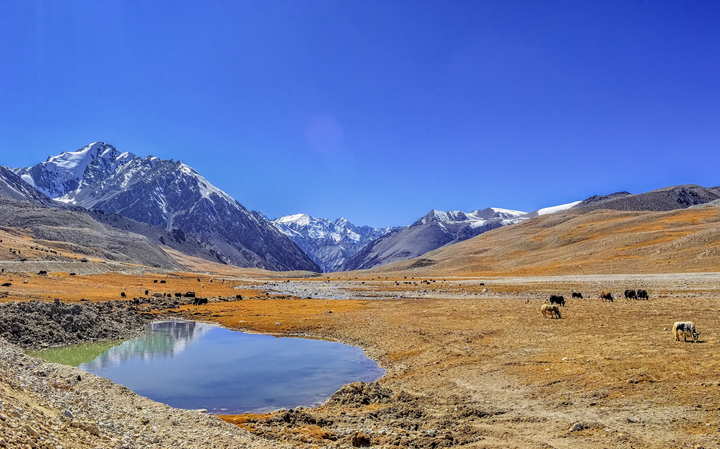
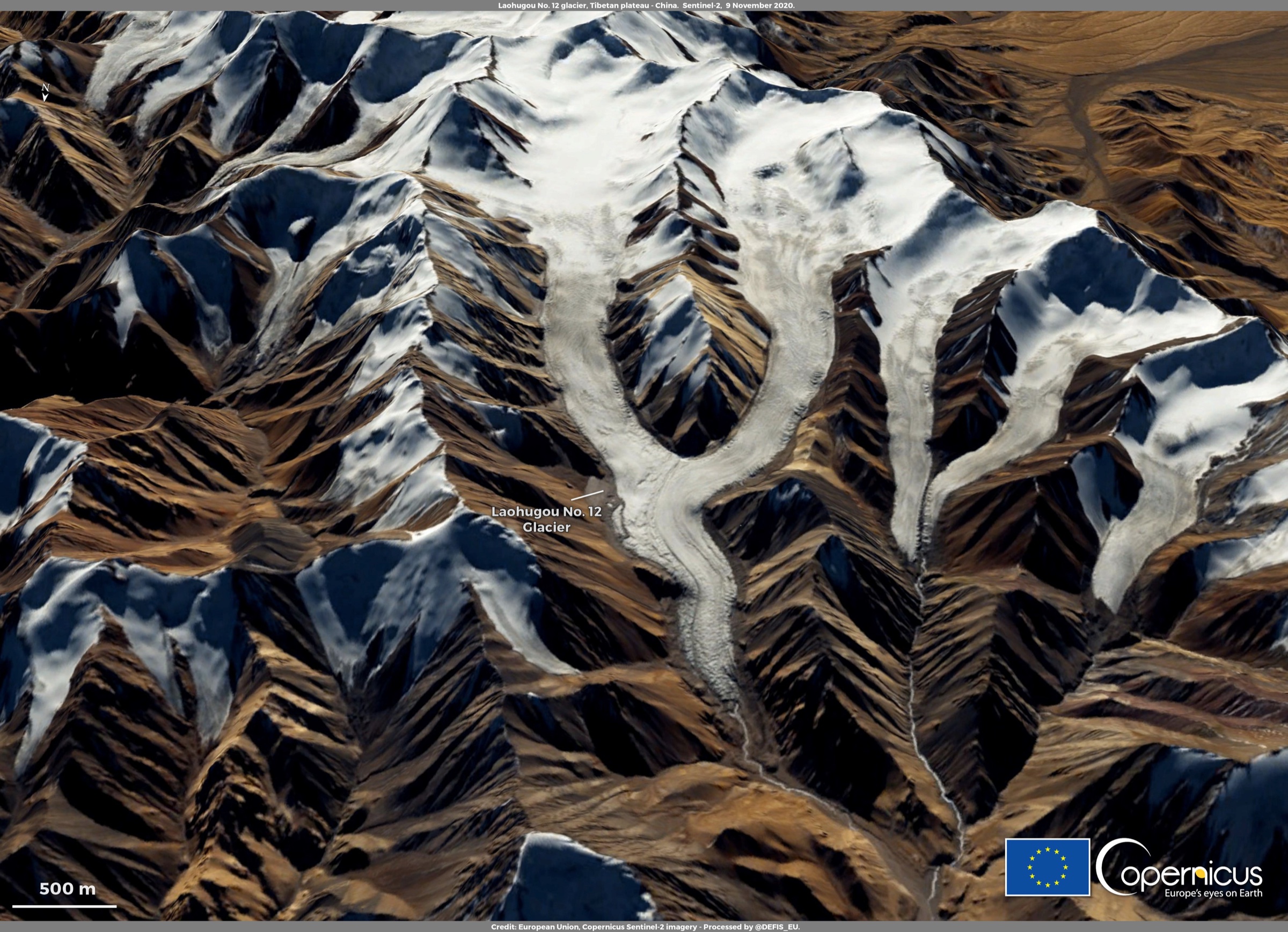
3. Touming Mengke / Laohugou No. 12 Glacier viewpoint approach
Snapshot
Itinerary
The candidate route is a legal, non-glacial approach to a viewpoint near Touming Mengke Glacier, also known as Laohugou No. 12 Glacier, in the Daxue Mountain part of the western Qilian system. The glacier itself is a major valley glacier; the catalogue route must remain on safe non-technical ground and must not enter crevassed ice.
Public trail geometry, permitted access points, walking distance and elevation gain are not verified. This entry should remain a candidate until an official access notice, current local guide map or GPS route from a lawful viewpoint can be obtained.
Why it is essential
Touming Mengke is the strongest high-mountain and glacier representative for the Dunhuang–Aksay western Qilian region. It balances the desert-edge Dunhuang walks with the glaciated Nan Shan landscape that feeds the Hexi Corridor’s endorheic river systems.
Equipment
Mountain hiking equipment: sturdy boots, warm and windproof layers, sun protection, sunglasses, water, food, navigation backup and emergency insulation. Do not carry glacier equipment as a substitute for permission or expertise; the selected day hike should avoid technical glacier travel.
Hazards and notes
Altitude, remoteness, rapidly changing weather, unverified road access and glacier hazards are the key issues. Crevasses, unstable moraine and icefall terrain require specialist skills and are outside the day-hike scope. Confirm protected-area rules and local permission before travel.
4. Dunhuang Yardang National Geopark viewpoint walks
Snapshot
Itinerary
Use the official geopark access system to visit the authorised yardang formations, adding short walks at the signed viewpoints where walking is permitted. The route is not a continuous wilderness hike; it is a protected desert geopark day with pedestrian sections between bus/vehicle stops and viewpoints such as the “Ghost City” formations.
Why it is essential
The yardang geopark is the western Dunhuang region’s defining wind-eroded landform. It gives the catalogue a major geological route that complements the dunes, cultural mountains and high Qilian glacier candidate.
Equipment
Standard hiking equipment adapted for desert: sun hat, sunglasses, sunscreen, wind layer, water, snacks and footwear suitable for gravel and sand. Carry extra water because shade is limited.
Hazards and notes
Do not leave marked or authorised walking areas. Heat, wind, dust, lack of water and long travel distance from Dunhuang are the main hazards. Night or sunset visits require confirmed transport back to Dunhuang.
5. Five Temple Caves / Danghe gorge cultural walk
Snapshot
Itinerary
The candidate route visits the Five Temple Caves, a small group of Buddhist cave temples in a gorge on the left bank of the Danghe River south of the Mogao Caves. A day-hike catalogue version should use only authorised site paths and gorge approaches, linking the cave viewpoints with a short walk along the river-gorge setting where access is allowed.
Precise visitor-path statistics and current opening arrangements are not verified. The route should remain a candidate until current site access, trail length and cultural-protection restrictions are confirmed.
Why it is essential
This walk adds the Danghe gorge and lesser-known Dunhuang-area Buddhist cave landscape to the western Qilian selection. It connects the mountain-fed river system, Silk Road cave tradition and Subei / Dunhuang edge geography.
Equipment
Standard hiking equipment: walking shoes, sun protection, water, wind layer and a navigation backup for the road approach. Respect cultural-site rules and photography restrictions.
Hazards and notes
Gorge access, cultural relic protection, rockfall, loose steps and heat are the main issues. Do not enter closed caves, climb on relic structures or walk beyond authorised paths.
Further reading
| Resource | Link |
|---|---|
| Wikipedia — Qilian Mountains | en.wikipedia.org |
| Wikipedia — Dunhuang | en.wikipedia.org |
| Wikipedia — Singing Sand Dunes (Dunhuang) | en.wikipedia.org |
| Wikipedia — Crescent Lake (Dunhuang) | en.wikipedia.org |
| 维基百科 — 三危山 | zh.wikipedia.org |
| Wikipedia — Touming Mengke Glacier | en.wikipedia.org |
| Wikipedia — Dunhuang Yardang National Geopark | en.wikipedia.org |
| Wikipedia — Five Temple Caves | en.wikipedia.org |
| Dunhuang Academy — e-dunhuang.com | e-dunhuang.com |