Regional overview
The Hengduan Mountains of western Sichuan and northwestern Yunnan are one of Asia’s great mountain-transition zones: deep river gorges, Tibetan sacred peaks, glacial lakes, alpine meadows, high forest, Bai and Naxi cultural landscapes, and road-accessible plateaus above 4,000 m. The region includes the Three Parallel Rivers landscape, Meili Snow Mountain / Kawagebo, Tiger Leaping Gorge, Daocheng Yading, Haba Snow Mountain, and Cangshan above Dali.
Day hiking here ranges from paved balcony paths and scenic-area boardwalks to hard high-altitude routes that many travellers normally split over two days. Altitude is the central planning issue. Several routes start above 3,000 m or climb above 4,500 m, and weather can shift from strong sun to snow, hail, or thunder in a single day.
Selection rationale
The five hikes below represent the Hengduan walking spectrum: the iconic Tiger Leaping Gorge high trail, a Tibetan pilgrimage waterfall walk in Yubeng, the high alpine lake route in Daocheng Yading, Cangshan’s cultural balcony path above Dali, and a strenuous wild lake route on Haba Snow Mountain. Route statistics are strongest where AllTrails records exist; official and regional tourism sources are used to verify access character, landmarks, and seasonal notes.
Summary table
| # | Hike | Country | Route type | Distance | Gain | Max elevation | Difficulty |
|---|---|---|---|---|---|---|---|
| 1 | Tiger Leaping Gorge High Trail | China | Point-to-point | 22.7 km (AllTrails); often described as 20–25 km over 1–2 days | 2,018 m (AllTrails) | Approx. 2,600–2,670 m | Hard |
| 2 | Lower/Upper Yubeng to Sacred Waterfall | China | Out-and-back | 12.0–13.4 km | 600–860 m depending on source/start | Approx. 3,657–4,000 m; exact high point varies by source | Hard |
| 3 | Daocheng Yading: Luorong Pasture to Milk Lake and Five-Color Lake | China | Out-and-back | 10.6 km (AllTrails) | 598 m | Approx. 4,600–4,700 m | Hard |
| 4 | Cangshan Jade Belt Cloud Road | China | Point-to-point / cableway-assisted | 15.8 km (AllTrails); about 16.2–18 km cited for full path | 1,348 m if starting low; much less if cableway-assisted | Approx. 2,500–2,600 m on the balcony path | Moderate–hard on foot; easy–moderate if cableway-assisted |
| 5 | Haba Snow Mountain — Black Lake | China | Out-and-back | 22.9 km (AllTrails) | 1,754 m | Approx. 4,100 m at Black Lake / Black Sea | Hard |
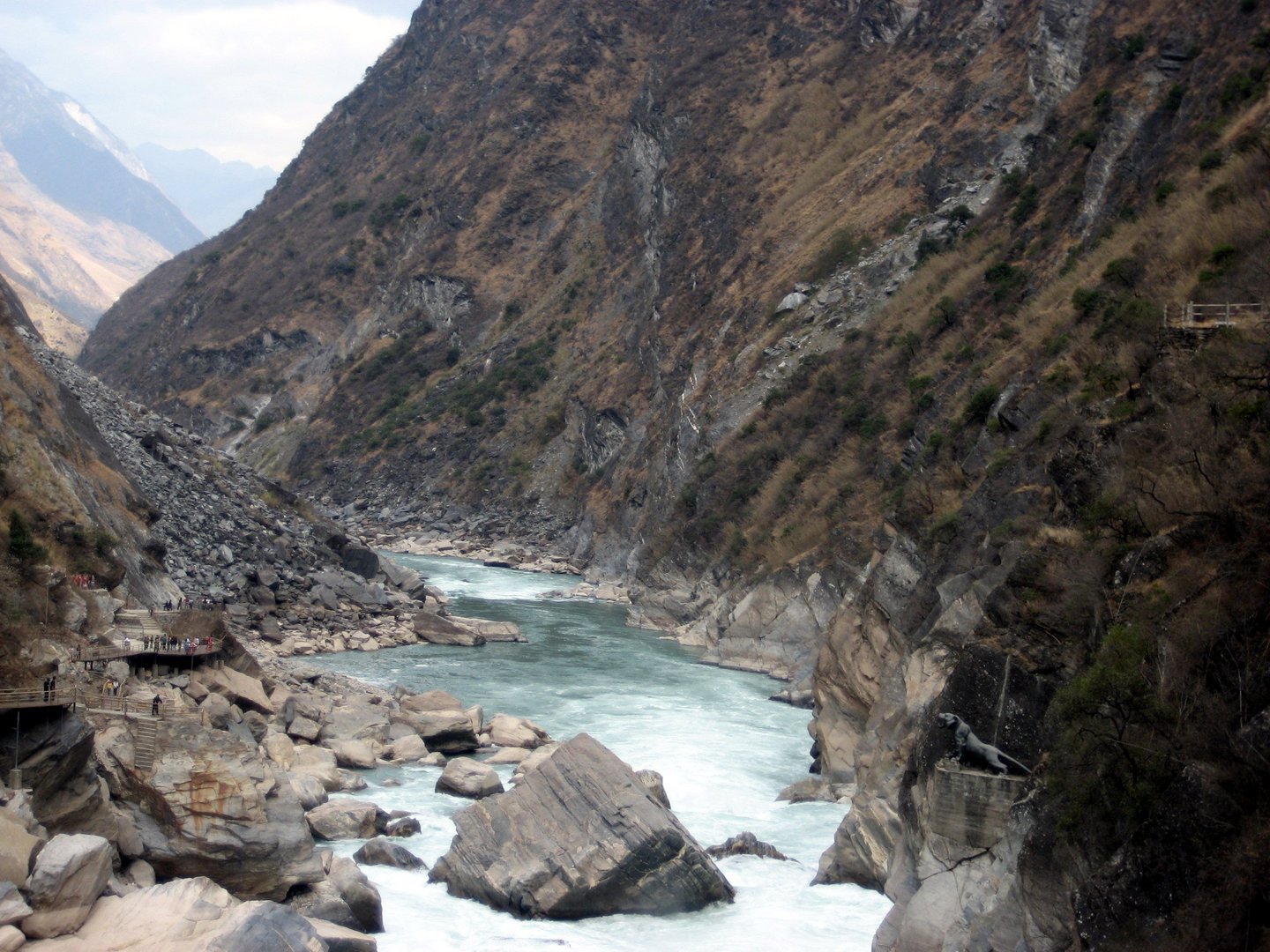
1. Tiger Leaping Gorge High Trail

Snapshot
Itinerary
The High Trail climbs above the Jinsha River from the Qiaotou/Hutiaoxia side, passing Naxi village terrain and the famous “28 bends” climb before traversing high above the gorge through guesthouse country. The route continues along balcony paths with views across to Jade Dragon Snow Mountain and down to the river, then descends towards Tina’s Guesthouse / Walnut Garden. Many hikers add a separate descent to the Middle Gorge or Tiger Leaping Stone, but that side trip is not included in the main statistics here.
For a strict day-hike catalogue, this is included as a famous strenuous one-day option for very fit walkers or as a shortened day section if starting higher near Naxi Guesthouse or Tea Horse/halfway accommodation. Most general travel sources still recommend two days for the full High Trail.
Why it is essential
Tiger Leaping Gorge is one of China’s best-known hiking landscapes and the classic Hengduan gorge walk: a high path cut between two snow mountains above one of the great upper Yangtze gorges.
Equipment
- Mountain hiking shoes or boots
- Sun hat
- Waterproof layer
- Warm layer
- Water and food
- Cash for local guesthouses/fees
- Offline map/GPS
- Headlamp for any late finish
Hazards and notes
- Heat, dehydration, landslides, narrow exposed path sections, loose surfaces, road construction, and seasonal washouts are the main hazards.
- Check current local trail status before departure.
- Do not descend into the Middle Gorge if weather, daylight, or local access rules are poor.
GPX / KML links
| Source | URL | Format / access | Reuse status |
|---|---|---|---|
| AllTrails: Tiger Leaping Gorge Trail | alltrails.com | Route page / app map | AllTrails terms apply; GPX export terms not verified; file reuse not confirmed |
| OpenStreetMap search: Tiger Leaping Gorge High Trail | openstreetmap.org | Map/search | OSM data is ODbL; geometry cross-check only |
External links
- AllTrails — Tiger Leaping Gorge Trail
- Visit Yunnan — Tiger Leaping Gorge hiking guide
- China Highlights — Tiger Leaping Gorge
2. Lower/Upper Yubeng to Sacred Waterfall
Snapshot
Itinerary
From Yubeng, the route follows the valley towards the sacred waterfall associated with Meili Snow Mountain pilgrimage. The path begins on more developed stone or concrete sections, then climbs through forest, prayer-flag areas, and mountain terrain to the waterfall basin. Pilgrims may circle the waterfall area clockwise; walkers should respect local religious practice and avoid blocking the path.
The distance and gain vary by whether the start is Lower Yubeng, Upper Yubeng, or the current guesthouse cluster. The route remains a day hike from Yubeng, not from Deqin or Shangri-La.
Why it is essential
The Sacred Waterfall route is the key pilgrimage day walk in Yubeng and gives the Hengduan entry a Tibetan sacred-mountain route rather than only scenic-area lake walks.
Equipment
- Boots or grippy hiking shoes
- Warm layer
- Rain shell
- Water and food
- Sun protection
- Headlamp
- Traction if ice is reported
- Trekking poles are helpful
Hazards and notes
- Altitude, slippery paved sections, ice, sudden storms, and late descents are the main issues.
- Yubeng access rules and transport patterns have changed over time; confirm current Xidang/Ninong access locally.
GPX / KML links
| Source | URL | Format / access | Reuse status |
|---|---|---|---|
| AllTrails: Yubeng Upper Village to Secret Falls | alltrails.com | Route page / app map | AllTrails terms apply; GPX export terms not verified; file reuse not confirmed |
| OpenStreetMap search: Yubeng Sacred Waterfall | openstreetmap.org | Map/search | OSM data is ODbL; geometry cross-check only |
External links
- AllTrails — Yubeng Upper Village to Secret Falls
- IntoTravelChina — Yubeng Village
- Visit Yunnan — Meili Snow Mountain trek
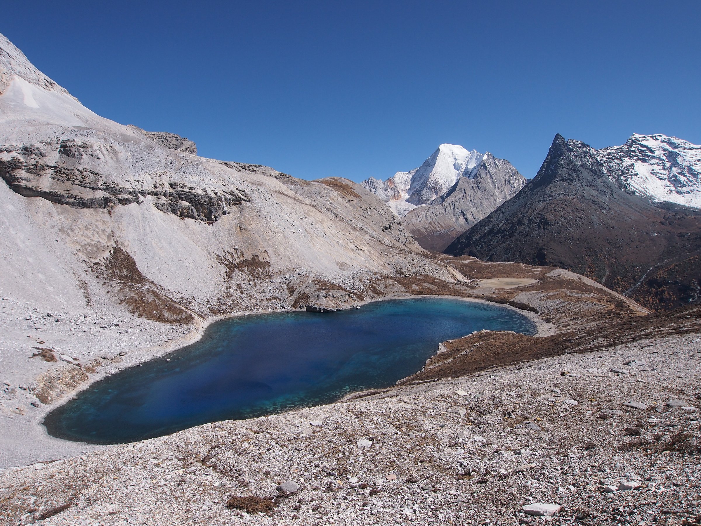
3. Daocheng Yading — Luorong Pasture to Milk Lake and Five-Color Lake
Snapshot
Itinerary
From Luorong Pasture, the route follows the long Yading “upper” walking line towards Milk Lake and Five-Color Lake. Sichuan travel sources describe a first section of relatively flatter walking from the electric-cart end, followed by steeper climbing to Milk Lake and then a further climb on the boardwalk/path to Five-Color Lake. Return the same way to Luorong Pasture for the scenic transport back down-valley.
Why it is essential
This is the signature high-altitude lake walk in Daocheng Yading: sacred snow peaks, alpine pasture, glacial lakes, and one of the most famous scenic-area hikes in western Sichuan.
Equipment
- Warm layers
- Waterproof/windproof shell
- Gloves/hat
- Grippy footwear
- Water and food
- Sun protection and sunglasses
- Personal medication for altitude planning as advised by a clinician
- Trekking poles are useful
Hazards and notes
- Altitude sickness is the main hazard. Move slowly, turn around if symptoms worsen, and do not underestimate the climb above 4,500 m.
- Weather can close the route or make the descent icy.
- Horse services, if operating, may only cover part of the route and should not be assumed.
GPX / KML links
| Source | URL | Format / access | Reuse status |
|---|---|---|---|
| AllTrails: Five Color Lake from Luorong Pasture | alltrails.com | Route page / app map | AllTrails terms apply; GPX export terms not verified; file reuse not confirmed |
| OpenStreetMap search: Luorong Pasture Five Color Lake | openstreetmap.org | Map/search | OSM data is ODbL; geometry cross-check only |
External links
- AllTrails — Five Color Lake from Luorong Pasture
- Sichuan Travel Guide — Yading visiting guide
- Sichuan Travel Guide — Luorong Yak Ranch
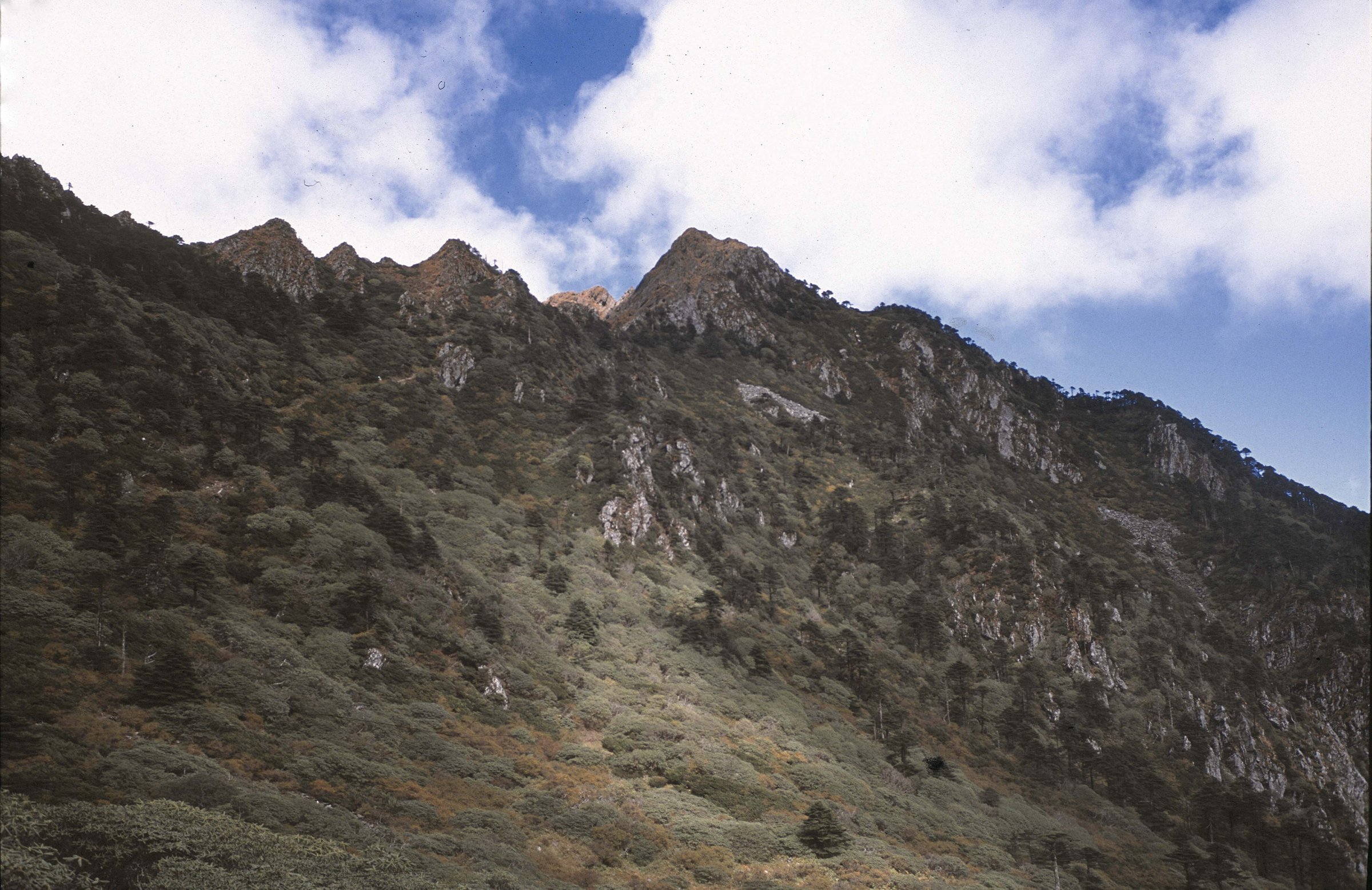
4. Cangshan Jade Belt Cloud Road
Snapshot
Itinerary
The Jade Belt Cloud Road traverses the flank of Cangshan above Dali, linking temples, streams, waterfalls, forested gullies, and long views over Erhai Lake. The path is often walked as a cableway-assisted balcony route: ride up, traverse the paved or stone path, and descend by another cableway or signed route. Strong walkers can start lower near Dali, but that changes the grade and total ascent significantly.
Why it is essential
Cangshan gives the Hengduan selection a culturally rich, accessible mountain balcony walk: Bai-region temples, lake views, waterfalls, and a long engineered path through a dramatic mountain wall.
Equipment
- Walking shoes
- Rain layer
- Warm layer
- Sun protection
- Water and food
- Map/GPS
- Carry extra time if relying on cableways for descent
Hazards and notes
- Storms, rockfall/landslide closures, wet stone, and cableway shutdowns are the main issues.
- Higher Cangshan ridge routes are more serious and are not part of this entry.
GPX / KML links
| Source | URL | Format / access | Reuse status |
|---|---|---|---|
| AllTrails: Cangshan and the Jade Cloud Road | alltrails.com | Route page / app map | AllTrails terms apply; GPX export terms not verified; file reuse not confirmed |
| OpenStreetMap search: Cangshan Jade Belt Cloud Road | openstreetmap.org | Map/search | OSM data is ODbL; geometry cross-check only |
External links
- AllTrails — Cangshan and the Jade Cloud Road
- SinoTales — Jade Belt Cloud Road guide
- China Travel Note — Cangshan Jade Belt Cloud Tour Road
5. Haba Snow Mountain — Black Lake
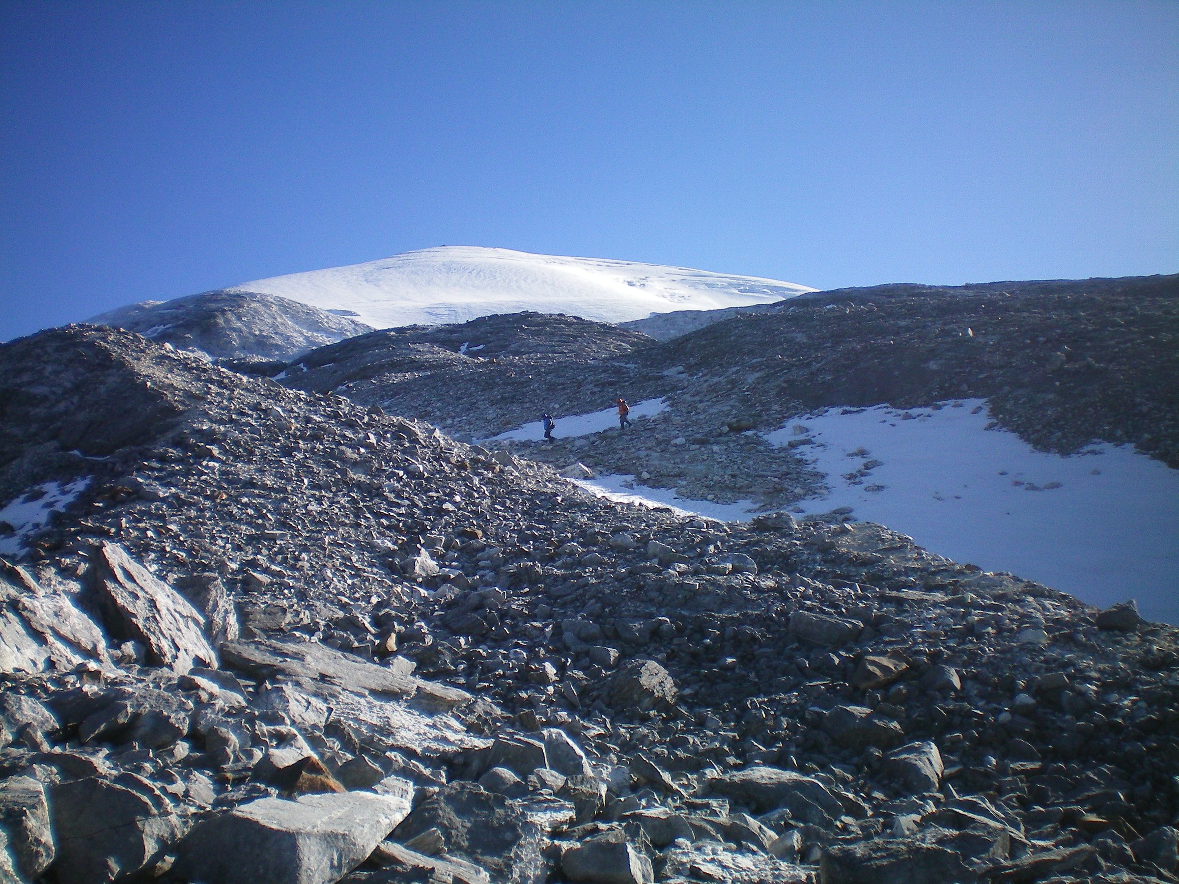
Snapshot
Itinerary
From Haba Village or a local trailhead above it, the route climbs through forest, pasture, rhododendron and alpine terrain towards Black Lake / Black Sea beneath Haba Snow Mountain. The return follows the same route. This is a lake hike, not an ascent of Haba Snow Mountain’s glaciated summit.
Why it is essential
Haba Black Lake adds the wild alpine-lake side of the Hengduan Mountains: high forest, glacial lakes, snow-peak views, and a strenuous but non-summit alternative to technical mountaineering.
Equipment
- Boots
- Warm layers
- Waterproof/windproof shell
- Gloves/hat
- Sun protection and sunglasses
- Water and food
- Headlamp
- Map/GPS
- First-aid kit
- Traction if snow or ice is present
- A local guide is recommended unless current route, access, and weather are well known
Hazards and notes
- Altitude, fatigue, remote terrain, storms, snow/ice, navigation, and limited rescue are serious concerns.
- Reports in 2026 travel discussions suggest some local Haba routes may be subject to closure or local control; confirm access in Haba Village before starting.
GPX / KML links
| Source | URL | Format / access | Reuse status |
|---|---|---|---|
| AllTrails: Haba Snow Mountain — Black Lake | alltrails.com | Route page / app map | AllTrails terms apply; GPX export terms not verified; file reuse not confirmed |
| OpenStreetMap search: Haba Snow Mountain Black Lake | openstreetmap.org | Map/search | OSM data is ODbL; geometry cross-check only |
External links
- AllTrails — Haba Snow Mountain — Black Lake
- China Trekking — Haba Snow Mountain
- Visit Colorful Yunnan — Haba Snow Mountain
- IntoTravelChina — Haba Snow Mountain
External links
| Source | URL |
|---|---|
| AllTrails — Tiger Leaping Gorge Trail | alltrails.com |
| Visit Yunnan — Tiger Leaping Gorge hiking guide | visit-yunnan.com |
| China Highlights — Tiger Leaping Gorge | chinahighlights.com |
| AllTrails — Yubeng Upper Village to Secret Falls | alltrails.com |
| IntoTravelChina — Yubeng Village | intotravelchina.com |
| Visit Yunnan — Meili Snow Mountain trek | visit-yunnan.com |
| AllTrails — Five Color Lake from Luorong Pasture | alltrails.com |
| Sichuan Travel Guide — Yading visiting guide | sichuantravelguide.com |
| Sichuan Travel Guide — Luorong Yak Ranch | sichuantravelguide.com |
| AllTrails — Cangshan and the Jade Cloud Road | alltrails.com |
| SinoTales — Jade Belt Cloud Road guide | sinotales.com |
| China Travel Note — Cangshan Jade Belt Cloud Tour Road | china-travelnote.com |
| AllTrails — Haba Snow Mountain — Black Lake | alltrails.com |
| China Trekking — Haba Snow Mountain | chinatrekking.com |
| Visit Colorful Yunnan — Haba Snow Mountain | visityunnanchina.com |
| IntoTravelChina — Haba Snow Mountain | intotravelchina.com |