Regional overview
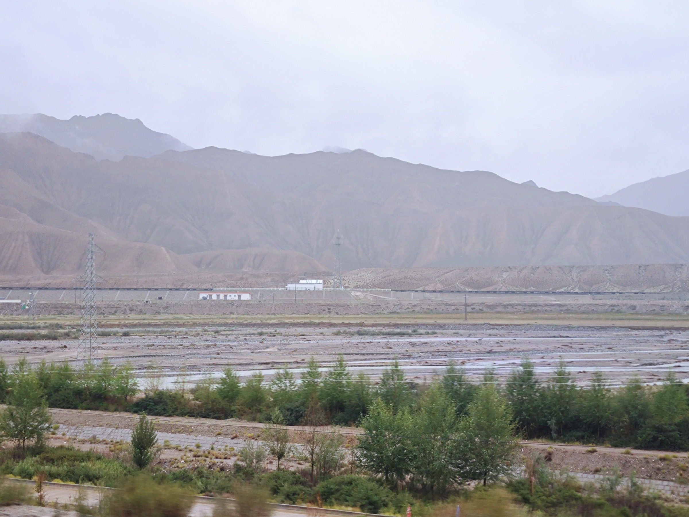
The Eastern Kunlun (东昆仑山, Dong Kunlun Shan) is the high northern bulwark of the Tibetan Plateau in northern Qinghai — the range that walls off the Qaidam Basin from the Hoh Xil (可可西里) plateau to the south. Golmud (格尔木, Ge’ermu), at 2,800 m on the basin floor, is the practical gateway: the only city of size in 600 km of desert and high plateau, and the staging point for everything that follows. Two roads climb south out of Golmud — the National Highway G109 (the Qinghai–Tibet Highway, 青藏公路) and the parallel Qinghai–Tibet Railway (青藏铁路) — and within 90 km they have climbed from saxaul-and-gravel basin to a 4,000 m alpine steppe at the foot of the main divide. The crest of the divide, crossed at the Kunlunshan Pass (昆仑山口, 4,767 m) about 160 km south of the city, is the watershed between the Qaidam endorheic system and the Yangtze headwaters; everything beyond the pass falls toward the Tongtian He (通天河).
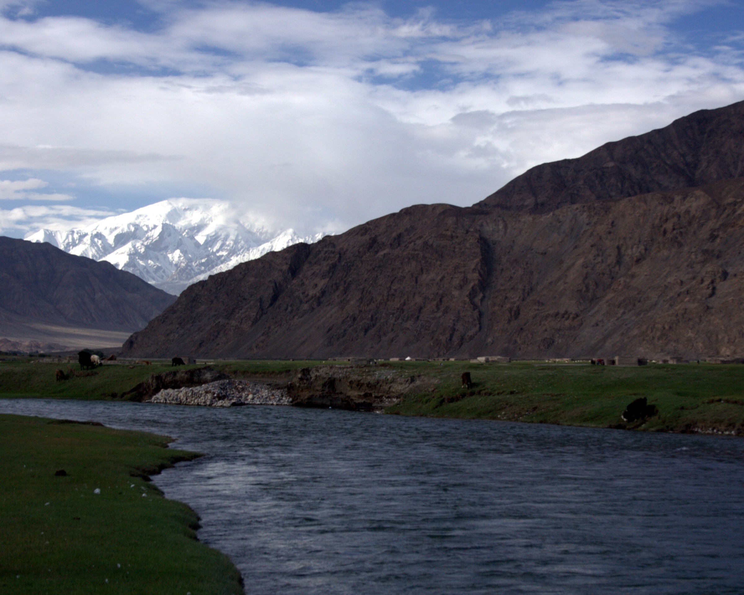
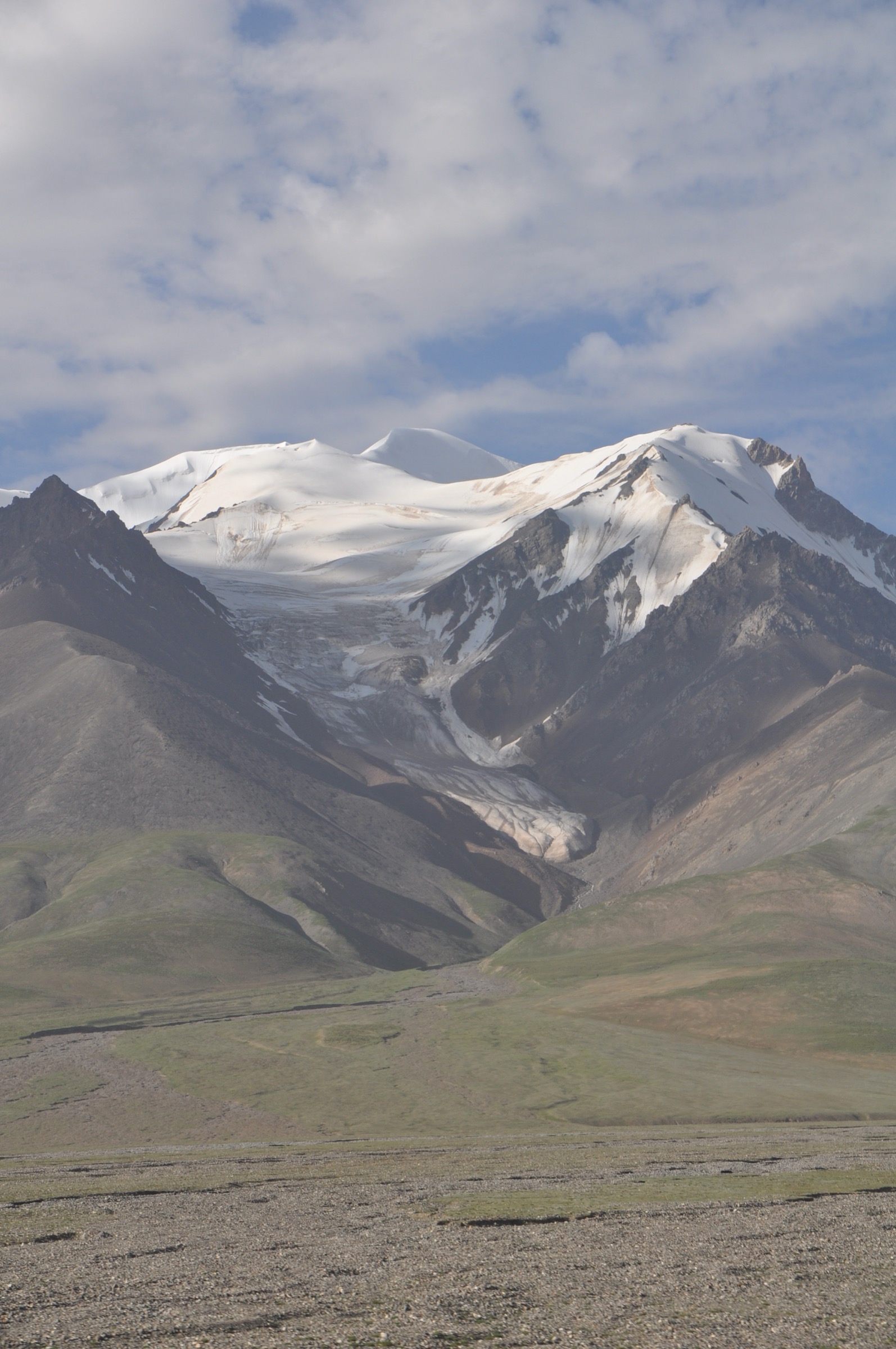
Topography on the eastern flank is austere. Yuzhu Peak (玉珠峰, 6,178 m) and its eastward continuation form a corniced glaciated wall a few kilometres south of G109; Yuxu Feng (玉虚峰, 5,980 m) — the sacred peak of Kunlun Daoist cosmology — sits just east of the pass. Between them, broad gravel plains at 4,200–4,500 m (Xidatan / 西大滩, Buka Daban / 布喀达坂 to the west) carry the road southward to the pass. The 2001 Kunlun M8.1 earthquake tore a left-lateral surface rupture some 400–450 km long along the foot of the main divide here — one of the longest continental ruptures ever recorded — and the scarp remains clearly visible from the roadside in the Xidatan area. North of the divide the landscape is sparse high-altitude desert and salt; south of it, the Hoh Xil reserve carries Tibetan antelope (chiru) over a roadless plateau toward the Yangtze sources.
Walking culture is virtually undeveloped. There are no waymarked trails in the western European sense, no scenic-area boardwalks, no published park GPX. What exists is a thin set of short interpretive walks at named G109 stops — the Kunlunshan Pass monument cluster, the Naij Tal (Nachitai / 纳赤台) post-station with its Kunlun Spring, the Wuji Longfeng Daoist temple at the foot of Yuxu Feng — together with the unofficial base-camp approach used by Yuzhu Peak expedition parties. None of these has the polish of a sanctioned park; all are roadside or temple-yard walks at altitudes that demand prior acclimatisation. The Hoh Xil National Nature Reserve, immediately south of the pass, is closed to all unaccompanied foot traffic; entry requires advance permits from the Hoh Xil administration in Golmud or Yushu, is granted sparingly, and never for casual hiking.
Operating reality is dominated by altitude. The lowest walk listed below begins at 3,560 m (Naij Tal); the highest, at 4,767 m (Kunlunshan Pass), is high enough that walkers arriving directly from sea level routinely experience acute mountain sickness within an hour. A minimum of two nights in Golmud (2,800 m) before any pass-side walking is standard practice on Chinese mountaineering-club itineraries, and even the Suonan Daji memorial stroll at Kunlunshan Pass should be approached as a high-altitude exertion. The useful walking window is mid-June to mid-September; the G109 corridor stays open year-round but is regularly closed by snowstorms between October and May, and the Yuzhu Peak base-camp turn-off becomes impassable to two-wheel-drive vehicles outside summer. There is no mobile signal away from the named towns and the named G109 service stations.
Selection rationale
Five walks are selected to span what genuinely exists for foot travel between Golmud and the Kunlunshan Pass, in declining order of accessibility and ascending altitude. Two — Kunlunshan Pass monument cluster and Naij Tal’s Kunlun Spring — are short, sanctioned, signed walks at named G109 stops; these are the only fully verified routes in the region. The other three — Yuzhu Peak south-slope base-camp approach, Wuji Longfeng Temple beneath Yuxu Feng, and the Xidatan roadside section of the 2001 earthquake rupture — are honest candidate-only walks: real features, real foot access, but with poorly documented route lines, no signed trailheads, and significant altitude or permit hazards. Each is labelled accordingly. None is a developed hike in the Alpine sense; together they are the catalogue’s honest answer to “what is actually walkable in the eastern Kunlun above Golmud”.
The Yuzhu Peak summit ascent (a 2–4 day non-technical glaciated trekking-peak climb, popular as a Chinese high-altitude training objective) is deliberately excluded from the selection — it is not a day hike under any reasonable definition. The Hoh Xil interior is excluded as permit-only restricted ground. The Qinghai–Tibet Highway and Railway are not “hikes” and are not counted as such.
Summary table
| # | Hike | Country | Route type | Distance | Gain | Max elevation | Difficulty |
|---|---|---|---|---|---|---|---|
| 1 | Yuzhu Peak south-slope base-camp approach | China | Out-and-back jeep-track + tundra | ~6–8 km return | ~150–250 m | ~4,650 m | Easy walking; serious altitude |
| 2 | Kunlunshan Pass monument cluster walk | China | Roadside spurs | ~1–2 km combined | <40 m | ~4,767 m | Easy walking; severe altitude |
| 3 | Naij Tal — Kunlun Spring interpretive walk | China | Spring-park loop + spurs | ~1–2 km | <30 m | ~3,600 m | Easy |
| 4 | Wuji Longfeng Temple — Yuxu Feng pilgrimage | China | Temple-yard + viewpoint stair | ~1–2 km | ~60–120 m | ~3,900 m | Easy–moderate |
| 5 | Xidatan G109 earthquake-rupture roadside walk | China | Roadside out-and-back | ~2–4 km | <30 m | ~4,400 m | Easy walking; high altitude |
No official park GPX has been located for any of the five walks. The Hoh Xil reserve administration, the Golmud municipal tourism authority and the Qinghai protected-area portal publish descriptive material but no GPX or KML downloads. OpenStreetMap geometry exists for G109 and the principal monuments but not for the foot lines off the road. On-site GPS capture is the only way to record an accurate boardwalk or jeep-track centreline.
1. Yuzhu Peak south-slope base-camp approach — 玉珠峰大本营
Snapshot
Itinerary
The south-slope base camp of Yuzhu Peak is the canonical staging point for the non-technical 6,178 m glaciated ascent used by Chinese mountaineering clubs as an introductory expedition. Foot access begins where the jeep track from G109 reaches its highest practical 4WD turnaround on the broad alluvial fan south of the peak. From that point a faint vehicle track and braided footpaths continue up the fan toward the moraine, gaining 150–250 m over roughly 3–4 km to reach the base-camp meadow at about 4,650 m. The line is open ground throughout — short alpine turf, gravel and patches of cushion plant — with the south face and lower glacier of Yuzhu rising directly above. Return is along the same line.
The walk is genuinely useful as an acclimatisation day for parties continuing south on G109 or attempting the summit, and as a stand-alone introduction to the south flank of the range for visitors not equipped for the climb. Exact start and turnaround points vary between mountaineering trip reports; there is no signed trailhead, no waymarking and no published park map.
Why it is essential
Yuzhu Peak is the most prominent and most photographed summit in the eastern Kunlun and the only 6,000 m glaciated peak in this range with an established non-technical line. The south-slope base-camp approach is the only way to stand at the foot of that face on a day walk — every other vantage on Yuzhu is either from the G109 roadside far below or from the glaciated upper mountain.
Equipment
- Sturdy boots
- Trekking poles useful on the moraine fan
- Extra warm layer and windproof shell — wind on the open fan is constant
- Hat and gloves outside high summer
- Sun protection (high UV at 4,500 m+)
- Water and food for the full day; no reliable water on the fan
- Navigation backup (GPS with offline base map; no mobile signal)
- Headtorch in case the descent runs late
- Altitude medication advisable
Hazards and notes
Altitude is the dominant hazard. The base-camp meadow sits 1,850 m above Golmud; walkers arriving directly from sea level should not attempt the approach without a minimum two-night acclimatisation in Golmud (2,800 m) and at least one day at 4,000 m. Afternoon snow squalls are routine even in July. There is no mobile signal, no shelter and no easy retreat once committed to the fan. The Hoh Xil National Nature Reserve boundary lies a few kilometres south of the south-slope base camp; do not cross it on foot. Drone use is restricted in this border-of-reserve zone.
External links
2. Kunlunshan Pass monument cluster walk — 昆仑山口
Snapshot
Itinerary
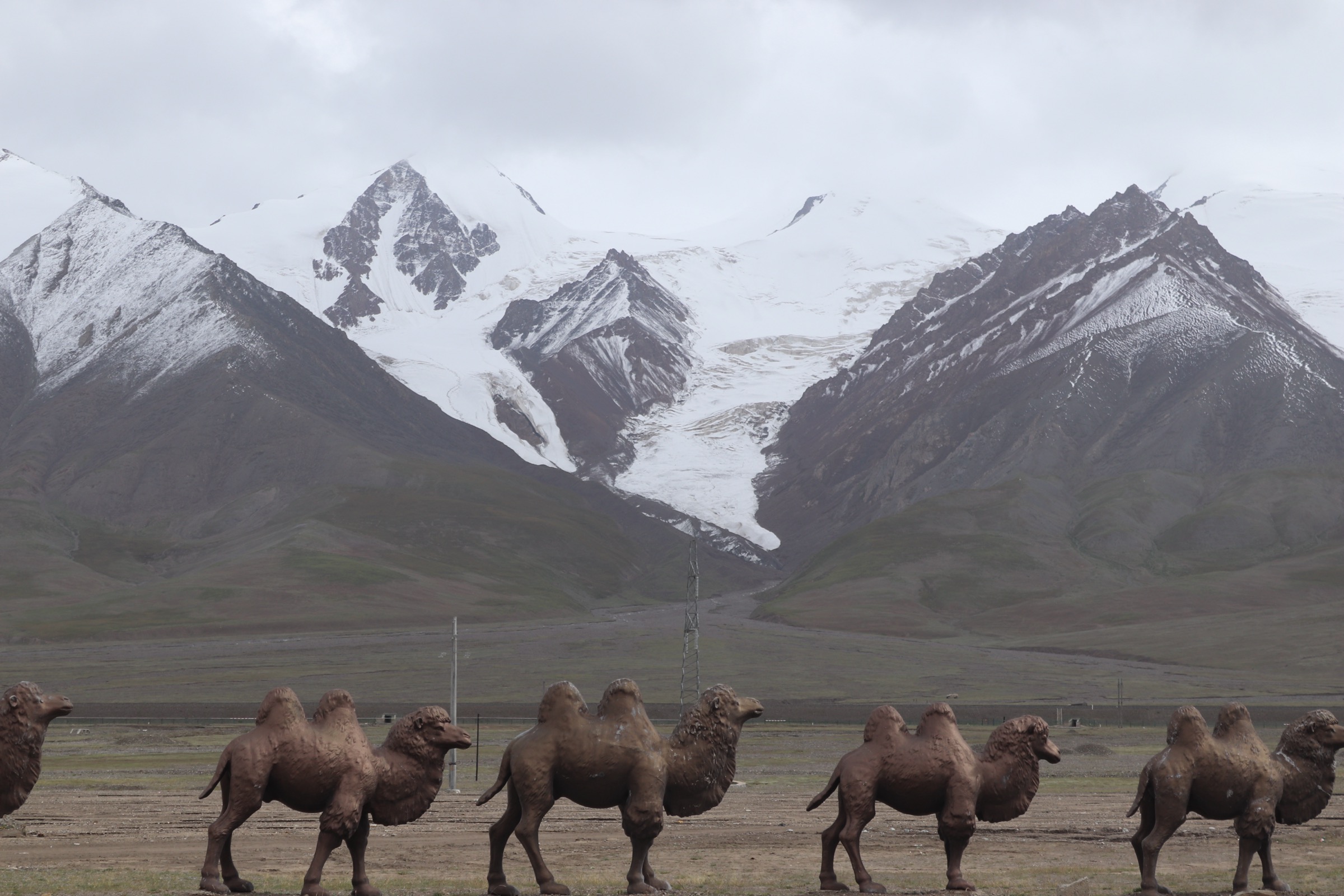
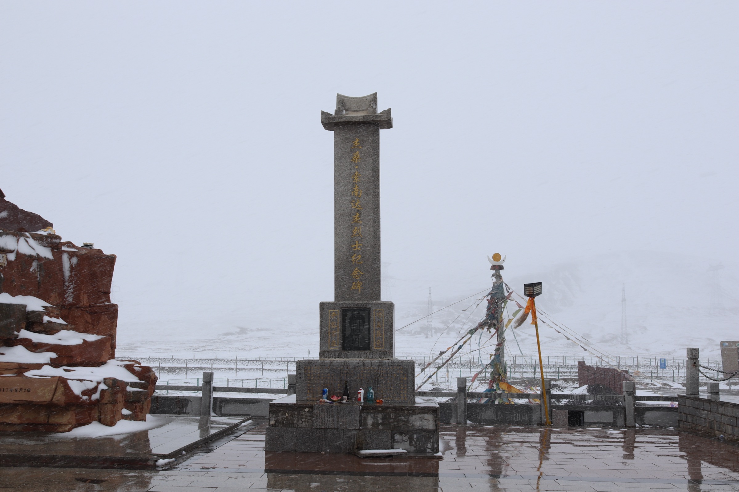
Kunlunshan Pass is the highest crossing on the Qinghai–Tibet Highway corridor north of Tanggula and the most heavily visited single waypoint on G109 between Golmud and Lhasa. Four named features cluster within a few hundred metres of the lay-by: the Kunlunshan Pass pillar (昆仑山口纪念碑), giving the elevation and the watershed line; the bronze statue of Jesong Suonan Daji (杰桑·索南达杰, 1954–1994), the Tibetan official and Hoh Xil anti-poaching patrol commander killed in a January 1994 firefight with poachers on the plateau south of the pass; the stele of the Suonan Daji Memorial (杰桑·索南达杰烈士纪念碑), set on a low mound east of the road; and the small Kunlun Mountain Geological Museum / Kunlun Pass earthquake-exhibit pavilion on the west side of the road, presenting the 2001 Mw 8.1 Kunlunshan earthquake and the geology of the eastern Kunlun.
The four features are connected by short paved or gravelled paths and by direct foot traverse across the lay-by. Most visitors complete the cluster in 45–90 minutes including time at each monument. The pass viewpoint itself gives an open south-facing panorama over the Hoh Xil plateau toward the Buka Daban and Bukadaban Feng (布喀达坂峰, 6,860 m) on a clear day.
Why it is essential
Kunlunshan Pass is the single most identifiable point on the Eastern Kunlun corridor — the watershed of the range, the highest visited stop on G109 north of Tanggula, and the monument cluster commemorating Suonan Daji is one of the most important environmental-history sites in modern China. The walk is also the simplest way to reach 4,700 m in the region with effectively no walking effort.
Hazards and notes
The pass is the single highest point in this catalogue and the place where unacclimatised visitors most often suffer acute mountain sickness. Walkers arriving directly from Golmud should treat the pass as a brief stop, not a sustained walk. The lay-by is exposed to ground blizzard in winter and to lightning in summer thunderstorms. Drone use over the monuments is restricted; the Hoh Xil reserve boundary begins immediately south of the pass and is patrolled.
Equipment
- Standard hiking shoes or boots
- Windproof shell layer (constant wind at the pass)
- Warm mid-layer and hat regardless of season
- Sun protection — UV at 4,767 m is severe
- Water and snacks
- Altitude medication advisable for unacclimatised visitors
External links
- Wikipedia — Sonam Dargye (Suonan Daji)
- Wikipedia — Hoh Xil National Nature Reserve
- Wikipedia — 2001 Kunlun earthquake
3. Naij Tal — Kunlun Spring interpretive walk — 纳赤台昆仑神泉
Snapshot
Itinerary
Naij Tal — historically a Qing-period post-station and now a small service settlement on G109 — sits at the mouth of the Kunlun River gorge where the road begins its sustained climb out of the Qaidam basin. The Kunlun Spring (昆仑神泉) is a cold artesian spring rising at the river-edge in a low pavilion-and-stele complex on the east side of the road, fenced and signposted; the water is widely held to be the cleanest reachable on the corridor and has been bottled commercially. A short paved loop and a couple of stone-flag stairways link the spring to the riverside terrace and back to the gate. From the gate, two natural spurs add interest: a 200 m walk west along the road brings the Qinghai–Tibet Railway’s Nachitai station into view, with the rail line crossing the river on a low truss bridge; and a 300 m walk south brings the foot of the gorge proper, where the Kunlun River runs in a basalt-rim channel.
Why it is essential
Naij Tal is the lowest and most accessible cultural-and-water-landscape walk in the eastern Kunlun corridor, the only low-altitude (sub-4,000 m) sanctioned walking stop between Golmud and the high pass, and the canonical first stop on any G109 trip out of Golmud. The Kunlun Spring is the most heavily photographed water feature in this part of the range and a natural acclimatisation pause before the climb to Xidatan.
Equipment
- Standard hiking shoes
- Light wind layer
- Sun protection
- Water bottle — refilling at the spring is part of the tradition
Hazards and notes
The river-edge terrace is unfenced in places; do not attempt to descend to the water during the late-spring high-flow period. The G109 traffic at the gate is constant and freight-heavy. The spring is officially open in daylight hours but is not gated overnight; respect the small stele complex and do not climb the pavilion. Litter from passing traffic is a real problem; pack out everything.
External links
4. Wuji Longfeng Temple — Yuxu Feng pilgrimage walk — 无极龙凤宫 · 玉虚峰
Snapshot
Itinerary
Wuji Longfeng Gong is the principal Daoist temple of the eastern Kunlun and the only built religious site directly associated with Yuxu Feng (玉虚峰, 5,980 m), the holy peak of the Kunlun Daoist sect and, in classical cosmology, the home of the goddess Yuxu — sister of the Jade Emperor. The temple sits at roughly 3,800 m on the lower slopes east of Kunlunshan Pass, reached by a short branch road from G109. The walk is a temple-yard circuit: through the main gate, around the principal hall, past subsidiary shrines and out to a hillside stair that climbs a low rise to a viewpoint looking south-east toward the glaciated wall of Yuxu Feng itself. The viewpoint is the standard pilgrimage culmination; the peak is not climbed and the upper slopes are not part of any walking line.
Why it is essential
Yuxu Feng is the only mountain in the Eastern Kunlun with a continuous Daoist pilgrimage tradition, and Wuji Longfeng Gong is the only walking-accessible focal point of that tradition. The cluster gives the cultural counterpoint to the largely secular Kunlunshan Pass walk and a rare south-facing view onto a glaciated 5,900 m peak from a sanctioned roadside walk.
Equipment
- Standard hiking shoes
- Wind layer
- Warm mid-layer
- Sun protection
- Water
- Small denomination cash for any offering at the temple
Hazards and notes
The stair is at 3,800–3,900 m; visitors arriving same-day from Golmud should expect breathlessness on the climb. Temple etiquette applies — remove hats inside the halls, do not photograph the interior altars without asking, do not point the camera at people in prayer. No mobile signal away from the G109 corridor. The temple’s posted opening hours have not been independently verified for 2026; confirm in Golmud before driving out.
External links
- Wikipedia — Kunlun Mountains (mythology)
- Great Tibet Tour — Kunlun Mountains: where gods of Taoism live
5. Xidatan G109 earthquake-rupture roadside walk — 西大滩
Snapshot
Itinerary
The 14 November 2001 Kunlunshan (Kokoxili) earthquake, magnitude Ms 8.1 / Mw 7.8, produced a left-lateral surface rupture along the Kunlun Fault system that extended for an unusually long ~400–450 km — among the longest continental ruptures ever recorded. The fault scarp crosses G109 obliquely on the Xidatan plain north of Kunlunshan Pass, and the line of disturbed ground — pressure ridges, offset stream channels and 1–4 m horizontal offsets in the alpine turf — remains clearly visible from the road two decades after the event. The walking line is an informal out-and-back along the foot of the scarp: park at a lay-by where the scarp visibly crosses the road, follow the rupture line east or west across the open steppe, and return along the same trace.
There is no signed trailhead and no published interpretive panel at the scarp itself; the Kunlunshan Pass Geological Museum at the pass, 30 km south, carries the formal exhibit. Local guides and Chinese-language overland trip reports identify the most photogenic short section as lying within a few hundred metres of the road; longer traverses are possible but pass through ground that is unmarked and entirely without shelter.
Why it is essential
The Xidatan scarp is the most visually striking and historically important geological feature in the eastern Kunlun corridor and one of the very few continental surface ruptures of its scale that is fully accessible from a paved highway. The walk gives a direct view of the fault that defines the northern edge of the Tibetan Plateau and that triggered the eastern Kunlun’s largest historical earthquake.
Equipment
- Standard hiking shoes
- Sturdy wind layer
- Extra warm layer (constant cold wind on the plain)
- Sun protection
- Water — no water on the plain
- Navigation backup
- Altitude medication advisable
Hazards and notes
Altitude exposure is severe; the plain sits at 4,300–4,400 m and walkers arriving directly from Golmud risk acute mountain sickness within the first hour. There is no shelter, no signal and no water. The Hoh Xil reserve boundary lies a short distance south of the lay-by; do not cross the boundary on foot. Drone use is restricted in this corridor. The roadside scarp is not fenced and the G109 carries fast freight traffic — cross only at safe sight lines.
External links
- Wikipedia — 2001 Kunlun earthquake
- MDPI — current stress state and seismic hazard, Kunlun Pass region after the 2001 Ms 8.1 earthquake
Missing data / follow-up work
- No official GPX or KML has been located for any of the five walks. The Golmud municipal tourism portal, the Hoh Xil reserve administration and the Qinghai protected-area portal publish descriptive material only. On-site GPS capture is the only route to reliable route geometry.
- Hike 1 (Yuzhu Peak base-camp approach): the highest 4WD turnaround is not signed and varies between trip reports; current Chinese-language mountaineering-club itineraries should be consulted before departure for the active access point.
- Hike 4 (Wuji Longfeng Temple): opening hours and any internal restrictions on photography or female access have not been independently verified for 2026.
- Hike 5 (Xidatan rupture): the precise roadside access points used by local geological tour parties are not published; confirm with a Golmud-based guide before driving out.
- Permit reality at the Hoh Xil reserve boundary: the southern edge of every walk in this catalogue is close to a reserve boundary where unaccompanied foot traffic is prohibited and where signage is sparse in Chinese only.
- No licence-compatible image has been located for Hikes 4 and 5. Wikimedia Commons coverage of Wuji Longfeng Gong and of the Xidatan rupture is currently absent or restricted to non-reusable licences.
- All distances and elevation figures for the unsignposted walks (Hikes 1, 4, 5) are estimates derived from satellite imagery and Chinese-language trip reports. Treat as approximate until confirmed by ground survey.