Regional overview
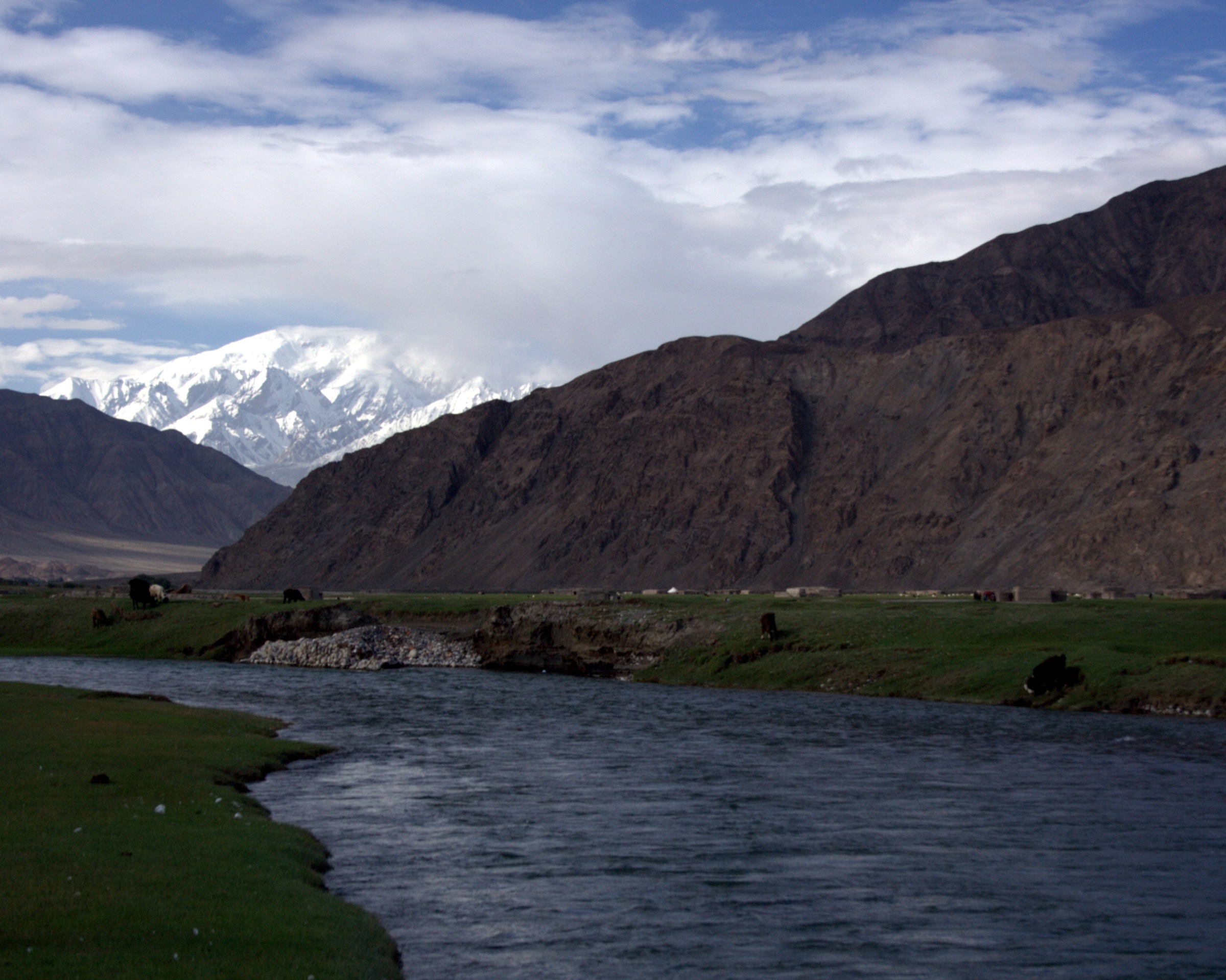
Qiemo (Cherchen / Qarqan) and Ruoqiang (Charklik) are the two largest counties by area in China, together covering roughly 340,000 km² of Bayingolin Mongol Autonomous Prefecture. Almost all of this area is desert, salt pan, or high-altitude wilderness; the inhabited oasis strip is a thin ribbon along the G315 highway, with the Taklamakan Desert to the north and the Central Kunlun and Altyn-Tagh (Arjin Shan) mountain front to the south. Qiemo town sits on the Qarqan River where it leaves the Kunlun; Ruoqiang sits on the Charklik oasis at the foot of the Altyn-Tagh, gateway to the dried Lop Nur basin.
The southern half of both counties lies inside the Altun Shan (Arjin Shan) National Nature Reserve, a 45,000 km² high-altitude cold desert between roughly 3,800 m and 5,800 m, with the Kumkol Basin around 4,500 m and three large saline lakes (Ayakkum, Aqqikkol, Jingyu). The reserve has no permanent road, no settlement, and is closed to general tourism; the few documented visits are scientific expeditions reaching the Yixiekepati ranger station at about 3,903 m via the Shimianmiine track from Yituanbulake. To the east, the Lop Nur Wild Camel National Nature Reserve covers another 67,000 km² of the Aqike valley, Gashun Gobi, and northern Altyn-Tagh slope, also with no public access. North of the G315 in eastern Ruoqiang lie the Sanlongsha and Bailongdui yardang fields. North-east lies the closed former Lop Nur nuclear test site.
For a day-hike catalogue, this region is genuinely sparse: most of the mountains, deserts, and salt pans are closed reserves or expedition-only objectives. The accessible walking offer is dominated by oasis-edge archaeological and cultural sites along the G315 corridor, plus yardang viewpoint walks east of Ruoqiang. Foreign-visitor access is more restrictive than in most of Xinjiang: G315 oasis towns are open, but any travel off the highway into the desert, into the Altyn-Tagh, or toward Loulan / Lop Nur requires permits processed at county PSB or above, and in the Loulan case is sometimes cited as costing on the order of hundreds of thousands of RMB for a foreign-vehicle convoy. Frontier-zone, nature-reserve and military closures stack across the southern and eastern halves of both counties.
Selection rationale
The five entries below cover the only accessible day-walking characters this region offers: an open archaeological-ruin walk (Miran), a yardang-landform short walk (Sanlongsha area), an oasis-edge cultural site (Zaghunluq tombs at Qiemo), a riparian poplar park (Qarqan River), and a Kunlun-foothill rock-art site (Molcha River petroglyphs). The high mountains, the Altun Shan interior, Loulan, and Ulugh Muztagh are deliberately excluded as multi-day expedition or closed-reserve territory. Three of the five entries are listed as Candidate only because their walking data is thin and their access conditions can change.
Summary table
| # | Hike | Country | Route type | Distance | Gain | Max elevation | Difficulty |
|---|---|---|---|---|---|---|---|
| 1 | Miran (Milan) Ruins Walk | China | Self-guided wander among ruins | Approx. 2-5 km cumulative | Negligible | Approx. 880 m | Easy |
| 2 | Sanlongsha Yardang Viewpoint Walk | China | Pull-off / short walks among yardangs | Approx. 1-3 km loop options | Approx. 15-20 m relative | Lop fringe, low elevation | Easy |
| 3 | Zaghunluq Mummy Tomb Site Walk | China | Open-air archaeological site walk | Under 1 km | Negligible | Approx. 1,200 m | Easy |
| 4 | Qarqan River Poplar Forest Park Walk | China | Riverside / forest loop | Approx. 2-4 km | Negligible | Approx. 1,200 m | Easy |
| 5 | Molcha River Petroglyphs Visit | China | 4WD approach plus short cliff-base walk | Under 1 km on foot | Minor | Approx. 1,800-2,500 m | Easy on foot, difficult to reach |
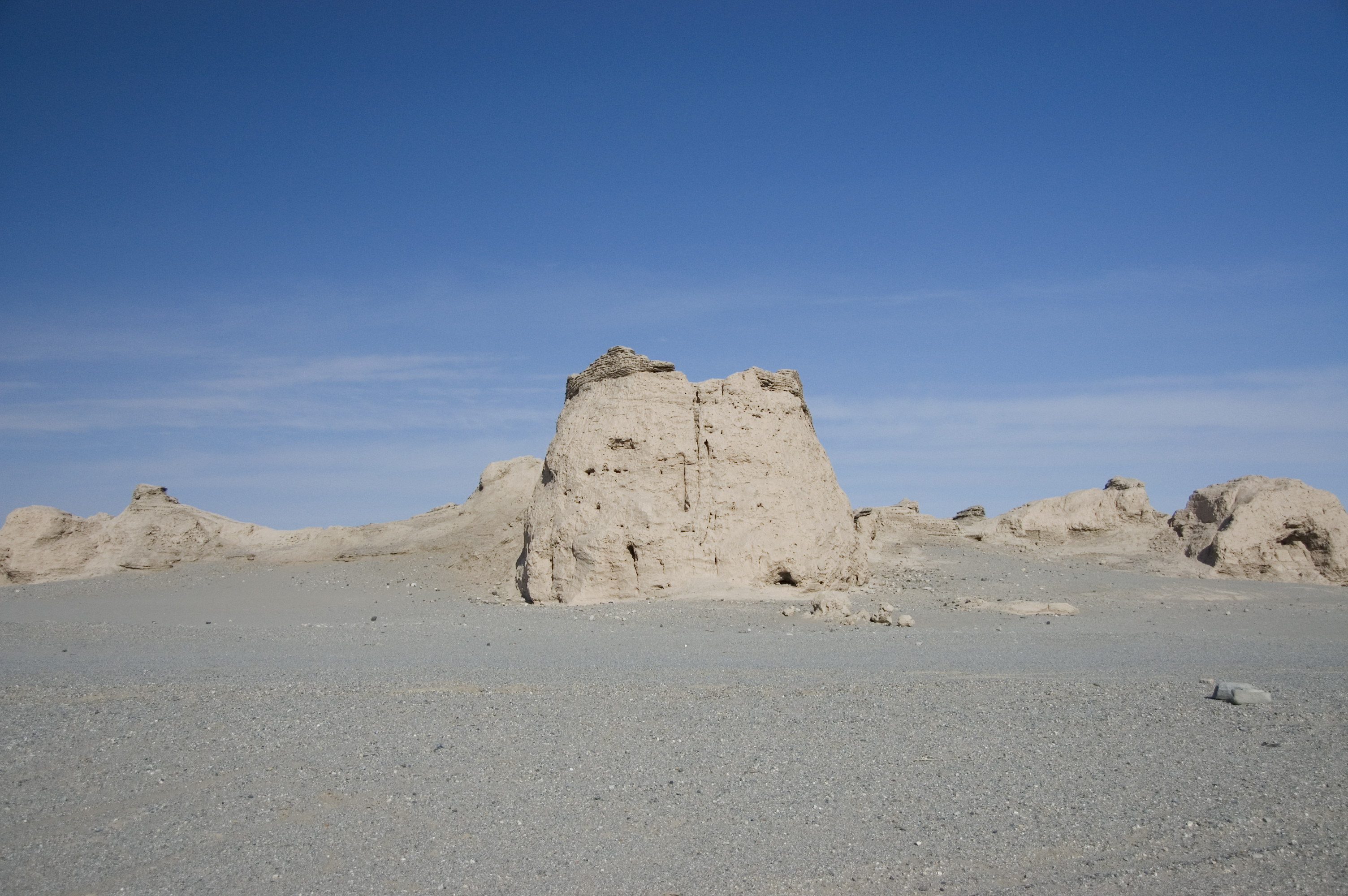
1. Miran (Milan) Ruins Walk
Snapshot
Itinerary
The route is a self-guided walk among the dispersed structures of the Miran archaeological complex on the southern fringe of Lop Nur. Visitors typically circle the standing fort, then walk between the Tibetan-period East and West Vihara and the surviving stupa mounds, with cumulative walking on the order of a few kilometres across flat desert ground at around 880 m. The site has no marked trail; orientation is by line of sight and on-site signage.
Why it is essential
Miran is the most accessible historic walking destination in this region: a major Silk Road and Tibetan-era site that can realistically be visited as a day trip from Ruoqiang, with no permit required beyond standard travel documentation.
Equipment
Standard hiking equipment plus desert kit: hat, sun-protective layers, sun cream, plenty of water, food, navigation backup, and a windproof layer for spring sand. Carry all water; there is none on site.
Hazards and notes
Sun exposure and heat are the principal hazards. Spring sandstorms can close the access road at short notice. Do not enter or climb the protected structures. Do not stray off the access tracks toward Lop Nur or northward into closed military or reserve areas.
GPX / KML links
| Source | URL | Format / access | Reuse status |
|---|---|---|---|
| OpenStreetMap search: Miran Ruoqiang | openstreetmap.org | Source map | OSM data is ODbL; landmark cross-check only |
| Wikipedia: Miran (Xinjiang) | en.wikipedia.org | Encyclopaedia entry | CC BY-SA 4.0; site identification and history context used |
| Wikipedia: Miran fort | en.wikipedia.org | Encyclopaedia entry | CC BY-SA 4.0; site context used |
External links
2. Sanlongsha Yardang Viewpoint Walk
Snapshot
Itinerary
The route uses informal pull-offs on the G315 / S235 corridor east of Ruoqiang to walk a short loop into the Sanlongsha yardang ridges. The yardangs are wind-eroded ridges of compacted lakebed sediment from former Lop Nur shorelines; they are aligned with the prevailing wind, giving the field its distinctive linear pattern. A formally developed visitor centre on the Xinjiang side is not consistently documented; published trail maps are absent.
Why it is essential
Sanlongsha is the only signature landform walk in this region accessible from the open G315 corridor and represents the wind-eroded desert character of Ruoqiang County.
Equipment
Standard desert hiking equipment: sun protection, hat, plenty of water, food, wind layer, sturdy shoes, and a working GPS or phone with offline mapping. Mark the access point on the way in to avoid disorientation on the way out.
Hazards and notes
The ridges look uniform and disorientation is the main hazard; never walk out of sight of the access vehicle without a fixed return bearing. Heat and sun are severe in summer. Sandstorms develop quickly. Avoid driving off-piste — soft sediment can trap vehicles.
GPX / KML links
| Source | URL | Format / access | Reuse status |
|---|---|---|---|
| OpenStreetMap search: Sanlongsha yardang Ruoqiang | openstreetmap.org | Source map | OSM data is ODbL; landmark cross-check only |
| TopChinaTravel: Yardang landforms in China | topchinatravel.com | Travel feature | Site terms apply; landform and location context used |
External links
- TopChinaTravel — Most beautiful yardan landforms in China
- Wild Great Wall — Yardang National Geopark guide
3. Zaghunluq Mummy Tomb Site Walk
Snapshot
Itinerary
The route combines the Zaghunluq site museum with a short walk through the surrounding cemetery area, the type locality of the so-called Cherchen Man mummies. The on-site walking is minor; the interest is the open-air archaeology and the museum’s mummy and textile displays.
Why it is essential
Zaghunluq is the closest cultural walking destination to Qiemo town and pairs naturally with the Qarqan River poplar park to give a one-day, Qiemo-based circuit.
Equipment
Easy hiking equipment: comfortable walking shoes, sun protection, water, and a wind layer in spring.
Hazards and notes
Standard heritage-site rules: do not enter excavation pits or roped-off areas. The site is exposed and hot in summer; visit early morning or late afternoon.
GPX / KML links
| Source | URL | Format / access | Reuse status |
|---|---|---|---|
| OpenStreetMap search: Zaghunluq Qiemo | openstreetmap.org | Source map | OSM data is ODbL; landmark cross-check only |
| Wikipedia: Cherchen Man | en.wikipedia.org | Encyclopaedia entry | CC BY-SA 4.0; site context used |
| Wikivoyage: Qiemo | en.wikivoyage.org | Travel wiki | CC BY-SA 4.0; visitor context used |
External links
4. Qarqan River Poplar Forest Park Walk
Snapshot
Itinerary
The route uses the park paths of the Qarqan River poplar forest ethnic park, set in a Populus euphratica grove along the lower Qarqan River outside Qiemo town. The park is documented in Qiemo travel material as covering about 150 acres, with riverside walking among mature desert poplars. The published material does not give a fixed circuit; the walk is a relaxed loop through the grove and along the river edge.
Why it is essential
The Qarqan poplar grove represents the river-oasis character of Qiemo and gives the catalogue a riverine counterweight to the dry tomb and yardang entries.
Equipment
Easy hiking equipment: comfortable shoes, sun protection, water, and a wind layer in spring.
Hazards and notes
Summer heat is the main hazard; visit early morning. Avoid the riverbank during flash-flood events upstream in the Kunlun. Stay clear of irrigation infrastructure.
GPX / KML links
| Source | URL | Format / access | Reuse status |
|---|---|---|---|
| OpenStreetMap search: Qarqan River Qiemo poplar park | openstreetmap.org | Source map | OSM data is ODbL; landmark cross-check only |
| TravelChinaGuide: Bayingolin Qiemo | travelchinaguide.com | Travel feature | Site terms apply; poplar park, distance, and seasonal context used |
External links
5. Molcha River Petroglyphs Visit
Snapshot
Itinerary
The route is short on foot but logistically demanding to reach. The Molcha (Moluoqie) River petroglyphs lie on a cliff face deep in the southern Qiemo valley network, climbing into the Central Kunlun foothills. Travel material describes thousands of Bronze and Iron Age carvings along the cliff. Access is by 4WD from Qiemo town, with no scheduled service; on the cliff itself, walking is a short stroll along the rock face.
Why it is essential
This is the only documented walking destination in this region that physically enters the Central Kunlun foothills rather than the desert fringe and stands in for the cultural and pastoral history of the high valleys.
Equipment
Mountain hiking equipment with extra reserves for self-sufficiency: sturdy shoes, sun and wind protection, warm layers, plenty of water and food, and a satellite-communicator if you have one. The drive carries far greater risk than the walk.
Hazards and notes
Access is the principal hazard: a long unpaved approach, no fuel beyond Qiemo town, no settlements en route, and possible permit and military controls. Confirm current access with a Qiemo-licensed operator before travel. Do not touch the petroglyphs.
GPX / KML links
| Source | URL | Format / access | Reuse status |
|---|---|---|---|
| OpenStreetMap search: Molcha River Qiemo | openstreetmap.org | Source map | OSM data is ODbL; landmark cross-check only |
| Wikivoyage: Cherchen | en.wikivoyage.org | Travel wiki | CC BY-SA 4.0; site identification and access context used |
| TravelWestChina: Cherchen (Qiemo) | travelwestchina.com | Travel feature | Site terms apply; petroglyph site context used |
External links
Missing data / follow-up work
- No GPX or KML files were located for any of the five routes. The Miran, Sanlongsha and Molcha visits in particular would benefit from operator-supplied tracks.
- Boardwalk, trail and circuit distances are not published for the Zaghunluq, Qarqan River poplar park or Molcha petroglyph sites.
- Access conditions for the Sanlongsha yardangs on the Xinjiang side of the Aqike valley should be confirmed locally; the better-developed Yardang National Geopark visitor infrastructure lies on the Gansu side at Dunhuang.
- Frontier-zone, military and nature-reserve closures dominate the southern half of both counties. The Altun Shan (Arjin Shan) National Nature Reserve, the Lop Nur Wild Camel National Nature Reserve, the Loulan ruins, and the Ulugh Muztagh approaches are all expedition or closed territory and are deliberately excluded from this day-hike set.
- A small number of higher-altitude pastoral walks may exist in the Qarqan and Molcha valleys but are not documented in English-language or mainstream Chinese hiking sources.
- No high-resolution licence-compatible photo above the project’s preferred 2,400 px long edge was located for this region. The article uses a CC BY-SA 1.0 Miran Fort image (around 3,008 × 2,000 px) from the British Library / IDP collection as the primary illustration.
External links
| Source | URL |
|---|---|
| Wikipedia — Qiemo County | en.wikipedia.org |
| Wikipedia — Qiemo River | en.wikipedia.org |
| Wikipedia — Altyn-Tagh | en.wikipedia.org |
| Wikipedia — Altun Shan National Nature Reserve | en.wikipedia.org |
| Wikipedia — Lop Nur Wild Camel National Nature Reserve | en.wikipedia.org |
| Wikipedia — Miran (Xinjiang) | en.wikipedia.org |
| Wikipedia — Miran fort | en.wikipedia.org |
| Wikipedia — Loulan Kingdom | en.wikipedia.org |
| Wikipedia — Ulugh Muztagh | en.wikipedia.org |
| Wikipedia — Cherchen Man | en.wikipedia.org |
| Wikivoyage — Charklik (Ruoqiang) | en.wikivoyage.org |
| Wikivoyage — Qiemo | en.wikivoyage.org |
| Wikivoyage — Cherchen | en.wikivoyage.org |
| TopChinaTravel — Milan Ruins | topchinatravel.com |
| TopChinaTravel — Yardang landforms in China | topchinatravel.com |
| TravelChinaGuide — Bayingolin Qiemo | travelchinaguide.com |
| Xinjiang travel regulations for foreigners (2026) | journeybeyondhorizon.com |