Regional overview
The Western Kunlun / Hotan-Keriya region rises from the southern edge of the Taklamakan Desert into the Kunlun Mountains. Around Hotan, Cele/Qira, and Yutian/Keriya, the walking surface is split between newly developed mountain scenic areas, high pastures, canyon boardwalks, jade-road and Silk Road heritage, and very remote ancient routes towards the Tibetan Plateau.
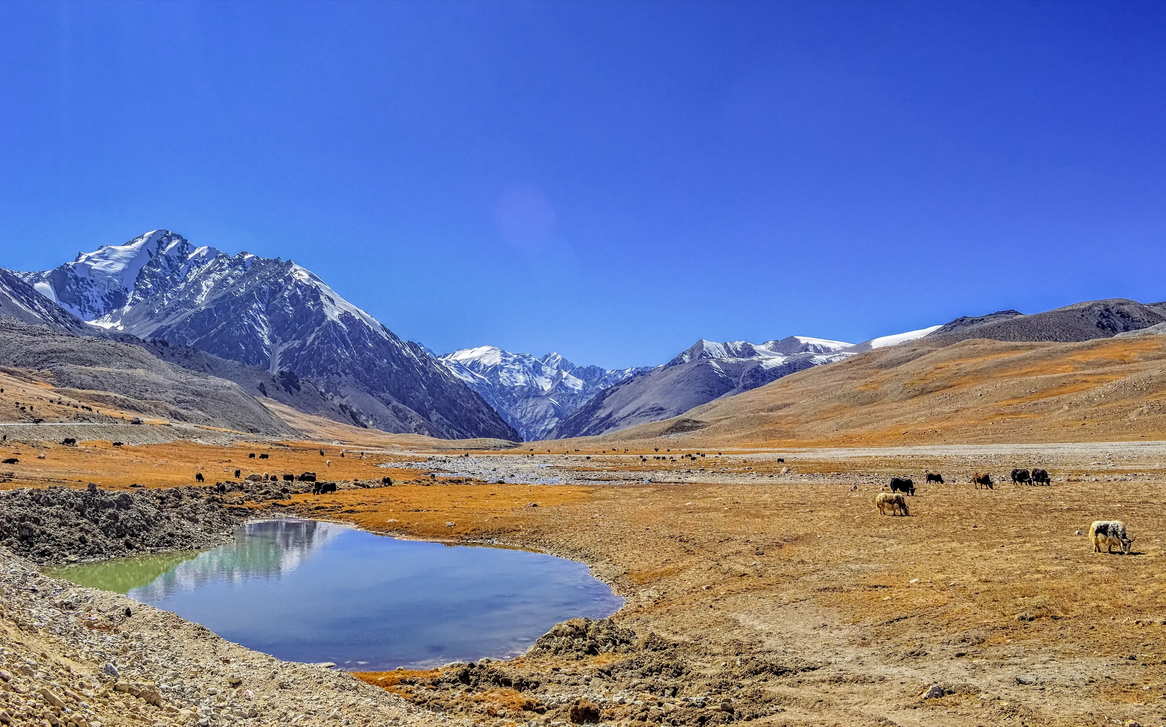
For a day-hike catalogue, the strongest verified walking cluster is Xinjiang Kunlun Mountain Scenic Area / Kunlun Mountain Grand Canyon near Cele and the First Ranch of the 14th Division. This developed scenic area has published information for a 5.8 km canyon boardwalk, a 2.3 km Tag Mountain wooden path, Banlange Meadow, Diru Peak viewpoints, visitor transport, opening hours, and safety notes. The Keriya Ancient Trail and Sangzhu Ancient Trail are explicitly unsuitable for casual day-hiking; modern travel sources describe them as extreme overland expedition routes with high passes, no resupply, poor communications, and serious risk.
The five entries below therefore prioritise developed scenic-area walks plus one Keriya River Basin foreland walk at Xiwule Longhu. Remote Kunlun crossings, glacier approaches, no-man’s-land routes, and ancient-road expeditions are excluded from the recommended day-hike set.
Selection rationale
The selection covers the region’s accessible hiking characters: canyon boardwalk, sky-road wooden path, alpine meadow, high viewpoint, and Keriya River Basin / poplar-forest foreland. The Kunlun Grand Canyon and Tag Mountain routes have the best published statistics; Xiwule Longhu is included to represent the Hotan-Keriya side even though it is lower and less mountainous.
Summary table
| # | Hike | Country | Route type | Distance | Gain | Max elevation | Difficulty |
|---|---|---|---|---|---|---|---|
| 1 | Kunlun Grand Canyon Boardwalk | China | Out-and-back / scenic-area boardwalk | 5.8 km boardwalk cited by scenic-area sources | Approx. 3,600-4,200 m depending section | Moderate | |
| 2 | Tag Mountain Wooden Path to Viewing Platform | China | Out-and-back boardwalk | 2.3 km cited by ChinaTourStar | Approx. 100-300 m | 3,700 m cited for highest part of wooden path | Moderate |
| 3 | Banlange Meadow Alpine Grassland Walk | China | Loop / out-and-back meadow walk | Approx. 2-5 km | Minor | 2,800-3,200 m | Easy-moderate |
| 4 | Diru Peak Viewpoint Walk | China | Lift/vehicle-assisted viewpoint walk | Approx. 1-3 km | Minor if lift/vehicle-assisted | 4,800 m cited for Diru Peak | Moderate-hard at altitude |
| 5 | Yutian Xiwule Longhu Boardwalk and Poplar Forest Trail | China | Loop / linked boardwalk and forest walk | Approx. 2 km poplar trail plus 2-hour boardwalk route | Minor | Easy-moderate |
1. Kunlun Grand Canyon Boardwalk
Snapshot
Itinerary
The route follows the developed Kunlun Grand Canyon boardwalk from the First Gate of Kunlun / canyon visitor area into the narrow canyon landscape. Published scenic-area information describes the canyon as 12 km deep and the walking boardwalk as 5.8 km, with Colorful Springs and Tag Mountain among the associated attractions.
The exact route geometry and current cableway/shuttle options were not available as a downloadable GPX. Treat this as a managed scenic-area walk and follow the current map on arrival.
Why it is essential
This is the strongest verified day-hike in the Hotan-side Western Kunlun: a real canyon walk in a developed mountain scenic area with published boardwalk distance.
Equipment
Standard to mountain hiking equipment: non-slip hiking shoes, windproof layer, warm layer, sun protection, 1.5 L water as recommended by scenic-area guidance, food, and map/phone.
Hazards and notes
The scenic area warns that some zones exceed 4,000 m, that heart-disease patients should be cautious, and that fire/smoking rules apply. Stay on the boardwalk and obey closures during snow season or cableway maintenance.
GPX / KML links
| Source | URL | Format / access | Reuse status |
|---|---|---|---|
| OpenStreetMap search: Kunlun Mountain Grand Canyon Hotan | openstreetmap.org | Source map | OSM data is ODbL; landmark cross-check only |
| Xinjiang Kunlun Mountain Scenic Area official site | xjklsjq.cn | Official scenic-area site | Site terms apply; no route-file licence found; official scenic-area context |
| LoongWander: Kunlun Mountain Scenic Area | loongwander.com | Travel/scenic-area page | Site terms apply; no route-file licence found; boardwalk length, opening, transport, and safety notes used |
External links
- Xinjiang Kunlun Mountain Scenic Area official site
- LoongWander — Kunlun Mountain Scenic Area
- ChinaTourStar — Kunlun Mountain Grand Canyon
2. Tag Mountain Wooden Path to Viewing Platform

Snapshot
Itinerary
The route climbs the wooden path along Tag Mountain, described by ChinaTourStar as about 2,300 m long and reaching 3,700 m at its highest point. The path leads to a viewing platform with broad views over lake, grassland, and the Kunlun Mountains.
This is a constructed scenic-area route. Follow the signed wooden path and do not shortcut across slopes or pasture.
Why it is essential
Tag Mountain gives the catalogue a clear high-view boardwalk route and a contrasting aerial perspective over the Kunlun Grand Canyon landscape.
Equipment
Non-slip hiking shoes, warm/windproof layer, water, sun protection, and trekking poles if allowed on the boardwalk.
Hazards and notes
Wooden paths can be slippery with rain, frost, or dust. Altitude and rapid weather changes are meaningful. Confirm whether the viewing platform and any cableway/road access are open.
GPX / KML links
| Source | URL | Format / access | Reuse status |
|---|---|---|---|
| OpenStreetMap search: Tag Mountain Kunlun Grand Canyon | openstreetmap.org | Source map | OSM data is ODbL; landmark cross-check only |
| ChinaTourStar: Kunlun Mountain Grand Canyon | chinatourstar.com | Travel/scenic-area page | Site terms apply; no route-file licence found; route length, altitude, and viewpoint context used |
External links
3. Banlange Meadow Alpine Grassland Walk
Snapshot
Itinerary
This route uses legal meadow paths and visitor areas at Banlange Meadow, staying clear of private grazing operations and sensitive vegetation. LoongWander describes the meadow as 2,800-3,200 m in elevation, 120 sq km in area, and a major alpine flower and pasture attraction in summer.
Exact walking statistics are unresolved because the source describes the meadow attraction rather than a fixed GPX route.
Why it is essential
Banlange Meadow represents the Western Kunlun’s high-pasture landscape, contrasting with the canyon boardwalks and high viewpoints.
Equipment
Comfortable hiking shoes, sun protection, windproof layer, water, and warm clothing for evening or bad weather.
Hazards and notes
Stay on established visitor paths and avoid disturbing livestock or wildlife. Weather, altitude, and lack of shade are the main issues. Horse-riding is a separate activity and should not be confused with the walking route.
GPX / KML links
| Source | URL | Format / access | Reuse status |
|---|---|---|---|
| OpenStreetMap search: Banlange Meadow Kunlun | openstreetmap.org | Source map | OSM data is ODbL; landmark cross-check only |
| LoongWander: Kunlun Mountain Scenic Area | loongwander.com | Travel/scenic-area page | Site terms apply; no route-file licence found; elevation, area, and attraction context used |
External links
4. Diru Peak Viewpoint Walk
Snapshot
Itinerary
The route uses the current official access system to reach Diru Peak’s viewing platform, then walks the open platform and signed paths for a 180-degree snow-mountain panorama. LoongWander cites Diru Peak at 4,800 m and a 300 sq m viewing platform with views of multiple peaks above 5,000 m.
Because the final access arrangement may involve scenic-road transfer or cableway operations, the distance is unresolved.
Why it is essential
Diru Peak provides the highest accessible viewpoint in the Kunlun Mountain Scenic Area route set and gives a direct look into the snow-mountain skyline.
Equipment
Mountain hiking equipment: warm windproof clothing, hat/gloves, sunglasses, sun protection, water, and cautious pacing. Consider altitude-sickness medication only under personal medical advice.
Hazards and notes
The altitude is serious even if the walk is short. Avoid rapid movement, running, or alcohol. Confirm weather, road, and cableway status before committing to the high viewpoint.
GPX / KML links
| Source | URL | Format / access | Reuse status |
|---|---|---|---|
| OpenStreetMap search: Diru Peak Kunlun | openstreetmap.org | Source map | OSM data is ODbL; landmark cross-check only |
| LoongWander: Kunlun Mountain Scenic Area | loongwander.com | Travel/scenic-area page | Site terms apply; no route-file licence found; elevation and viewpoint context used |
External links
5. Yutian Xiwule Longhu Boardwalk and Poplar Forest Trail
Snapshot
Itinerary
The route begins at the Xiwule Longhu Scenic Area visitor centre, follows the Longhu boardwalk section, then links to the poplar forest core area’s hiking trail. LoongWander describes a one-day itinerary with a two-hour boardwalk stroll and a 1.5-hour poplar forest hike, and notes a 2 km hiking trail in the poplar forest core area.
This route is lower and less mountainous than the Kunlun Grand Canyon routes, but it represents the Keriya River Basin / oasis-foreland side of the region.
Why it is essential
The Hotan-Keriya region is defined by the transition from Kunlun water sources to desert-oasis ecosystems. Xiwule Longhu adds that foreland river and poplar-forest character to the mountain-heavy selection.
Equipment
Comfortable walking shoes, sun protection, water, wind layer in shoulder season, and insect/tick awareness in vegetated areas.
Hazards and notes
Summer heat, dust, visitor-area rules, and water-edge safety are the main issues. The route is not a substitute for the dangerous Keriya Ancient Trail into the Kunlun and Tibetan Plateau.
GPX / KML links
| Source | URL | Format / access | Reuse status |
|---|---|---|---|
| OpenStreetMap search: Xiwule Longhu Yutian | openstreetmap.org | Source map | OSM data is ODbL; landmark cross-check only |
| LoongWander: Yutian Xiwule Longhu Scenic Area | loongwander.com | Travel/scenic-area page | Site terms apply; no route-file licence found; boardwalk, poplar trail, and timing context used |
External links
- LoongWander — Yutian Xiwule Longhu Scenic Area
- China Dragon Travel — Xinjiang to Tibet overland routes (Keriya Ancient Trail warning context)
External links
| Source | URL |
|---|---|
| Xinjiang Kunlun Mountain Scenic Area official site | xjklsjq.cn |
| LoongWander — Kunlun Mountain Scenic Area | loongwander.com |
| ChinaTourStar — Kunlun Mountain Grand Canyon | chinatourstar.com |
| LoongWander — Yutian Xiwule Longhu Scenic Area | loongwander.com |
| China Dragon Travel — Xinjiang to Tibet overland routes | chinadragontravel.com |
| Yutian County government — ecology note on Keriya Ancient Trail | xjyt.gov.cn |