Regional overview
The Bayan Har Mountains (巴颜喀拉山, Bayankala Shan) form the southern wall of the Kunlun system in the central Tibetan Plateau, running roughly 760 km west-to-east through southern Qinghai. The range is the watershed between the Yellow River (Huang He) and the Yangtze (Tongtian He): the broad gravel plateaus on its northern flank drain into the headwater wetlands of the Yellow River around Madoi (Maduo, 玛多, 4,260 m); the southern flank feeds the upper Yangtze through Yushu. Average crest elevations sit between 5,000 and 5,500 m, with isolated peaks above 5,900 m, but the country reads more as high steppe than as mountain — long undulating gravel and tundra plains pierced by occasional snow ridges and by the two largest freshwater lakes on the plateau, Gyaring Hu (扎陵湖, 4,294 m) and Ngoring Hu (鄂陵湖, 4,272 m).
Two prefectural seats give practical access. Madoi township, headquarters of Madoi County, sits on the lakeshore plain at the foot of the range and is the only logistical staging point for the Yellow River source country: from here the National Highway G214 (Xining–Jiegu) climbs south over the Bayan Har Pass (巴颜喀拉山口, about 4,824 m by the most-cited Chinese signage) into Yushu Prefecture and continues toward Yushu City (Jyekundo, 3,700 m), the second base for the eastern end of the range. East of the main divide, Jiuzhi County (久治, Golog Prefecture) reaches the Nianbaoyuze massif (年保玉则 / Nyainpo Yutse, 5,369 m) — a separate eastern outlier traditionally counted with the Bayan Har region, holy to both Tibetan Buddhism and Bön and the site of one of the most photographed lake-and-spire landscapes in Amdo.
Walking infrastructure across the range is minimal and recently more restricted. There are no waymarked European-style trails, no published park GPX, and the principal monuments along G214 — the Niutou Bei (牛头碑, Ox-head Stele) above Ngoring Hu, the Bayan Har Pass stele cluster — are roadside short-walks rather than developed routes. The Sanjiangyuan (Three-Rivers Source) National Park, which absorbed the Yellow River source country in its 2021 designation, prohibits unaccompanied foot traffic away from the few sanctioned interpretive sites; the Nianbaoyuze geopark in Jiuzhi has been closed to tourism since 2018 for ecological rehabilitation and remains closed at the time of writing. What remains accessible is a tightly bounded set of short, mostly roadside walks at 4,200–4,800 m altitude, plus a single longer lakeshore line at Ngoring Hu where local guides operate from Madoi.
Operating reality is dominated by altitude and weather. Every walk in this catalogue begins above 4,200 m; two top out above 4,600 m. Acute mountain sickness on arrival from Xining (2,260 m) by overnight bus or shared vehicle is routine, and a minimum of two nights in Madoi (4,260 m) before any walking is standard practice on Chinese trekking-club itineraries. The walking window is mid-June to mid-September; the G214 stays officially open year-round but is regularly closed by ground blizzards between late October and early May, and the lakeshore tracks are impassable in the snow months. There is no mobile signal outside Madoi township and the named G214 service stops; permits for the Sanjiangyuan core area are issued sparingly by the Sanjiangyuan National Park administration in Xining and are not granted for casual hiking.
Selection rationale
Five walks are selected to span what is genuinely accessible to foot travel in the headwaters country: two sanctioned roadside monument walks on G214 (Bayan Har Pass and the Madoi First Bridge), one short summit-stroll to the Niutou Bei stele above Ngoring Hu, one longer lakeshore line at Ngoring Hu’s northern bay, and one candidate-only entry for Nianbaoyuze’s Yaonü Lake — included as the historical reference for the most photographed walk in the eastern range, but flagged as closed since 2018. None of these is a developed mountain hike in the Alpine sense; together they are the catalogue’s honest answer to “what is walkable in the Bayan Har / Yellow River headwaters region under current park rules”.
Multi-day treks across the high plateau (the classic Yellow River source circuit via Gyaring Hu, the Bayan Har crest traverses) are excluded as outside the day-hike scope and as currently subject to Sanjiangyuan permit restrictions. The Yushu side of the range is excluded from this catalogue: it belongs to the central Tibetan Plateau working unit and will be covered separately. The Nianbaoyuze classic three-day pilgrimage circuit is excluded as a multi-day route and is currently inaccessible regardless.
Summary table
| # | Hike | Country | Route type | Distance | Gain | Max elevation | Difficulty |
|---|---|---|---|---|---|---|---|
| 1 | Niutou Bei stele summit walk above Ngoring Hu | China | Out-and-back stair + ridge spur | ~2–3 km return | ~150–200 m | ~4,610 m | Easy walking; severe altitude |
| 2 | Ngoring Hu (Eling Hu) northern lakeshore walk | China | Out-and-back along the lakeshore | ~6–10 km | <80 m | ~4,290 m | Easy; high altitude |
| 3 | Bayan Har Pass — G214 stele cluster walk | China | Roadside spurs | ~1–2 km combined | <40 m | ~4,824 m | Easy walking; extreme altitude |
| 4 | Madoi — Yellow River First Bridge heritage walk | China | Riverbank loop with bridge spur | ~2–3 km | <30 m | ~4,260 m | Easy |
| 5 | Nianbaoyuze — Yaonü Lake (closed) | China | Out-and-back lake-shore trail | ~10–14 km return when open | ~300–500 m | ~4,300 m | Closed since 2018 |
No official park GPX has been located for any of the five walks. The Sanjiangyuan National Park administration, the Golog Prefectural tourism portal and the Madoi county tourism bureau publish descriptive material but no GPX or KML downloads. OpenStreetMap geometry exists for the G214 corridor, the Niutou Bei access road, and the lakeshore tracks at Ngoring Hu but is incomplete and not signed on the ground. On-site GPS capture is the only way to record an accurate route line.
1. Niutou Bei stele summit walk above Ngoring Hu — 牛头碑
Snapshot
Itinerary
The Niutou Bei (牛头碑, “Ox-head Stele”) is the canonical viewpoint of the Yellow River headwaters: a 7 m granite-and-bronze ox-head monument set on a low hill above Ngoring Hu’s southern shore, marking the ceremonial source of the river. The walk begins at the small car park at the foot of the access road, where a 600 m stone stair climbs steeply through low cushion-plant turf to the stele platform at about 4,610 m. From the platform a shallow open ridge spur runs another 400–500 m west, giving wider panoramas over Ngoring Hu to the north and across the broad headwater wetlands to the south. Return is along the same line.
The stair is fenced and surfaced; the ridge spur is open ground without way-marking but is easy to follow in clear weather. Information panels at the foot of the stair give the Tibetan and Chinese names of the surrounding features. Photography from the platform is unrestricted. The stele itself is an active pilgrimage object — prayer flags ring the platform and small ceremonial offerings are common.
Why it is essential
The Niutou Bei is the single most identifiable monument in the Yellow River source country and the highest sanctioned roadside walk in this catalogue with a true panoramic summit. It is the canonical starting point for any visit to the headwaters and the only walk in the region that combines a short stair with a genuine plateau-summit viewpoint at over 4,600 m.
Equipment
- Sturdy walking shoes — the stair is steep and stone is uneven in places
- Trekking poles useful on the stair
- Windproof shell — wind on the platform is constant
- Warm mid-layer and hat regardless of season
- Sun protection — UV at 4,600 m is severe
- Water and snacks; no water on the hill
- Altitude medication advisable
Hazards and notes
Altitude is the dominant hazard. The platform sits 350 m above Madoi and walkers arriving from Xining without acclimatisation routinely experience acute mountain sickness on the climb. The stair is exposed to lightning in summer thunderstorms and to ground blizzard outside the summer window. The platform is unenclosed at its outer edges; keep children well back. The wider Sanjiangyuan National Park rules apply — do not leave the marked stair or take any rocks, plants or prayer-flag fragments.
External links
2. Ngoring Hu (Eling Hu) northern lakeshore walk — 鄂陵湖
Snapshot
Itinerary
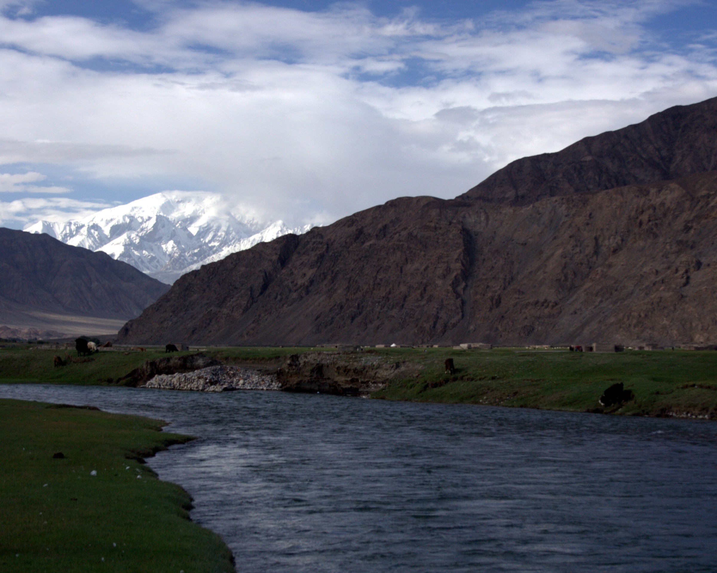
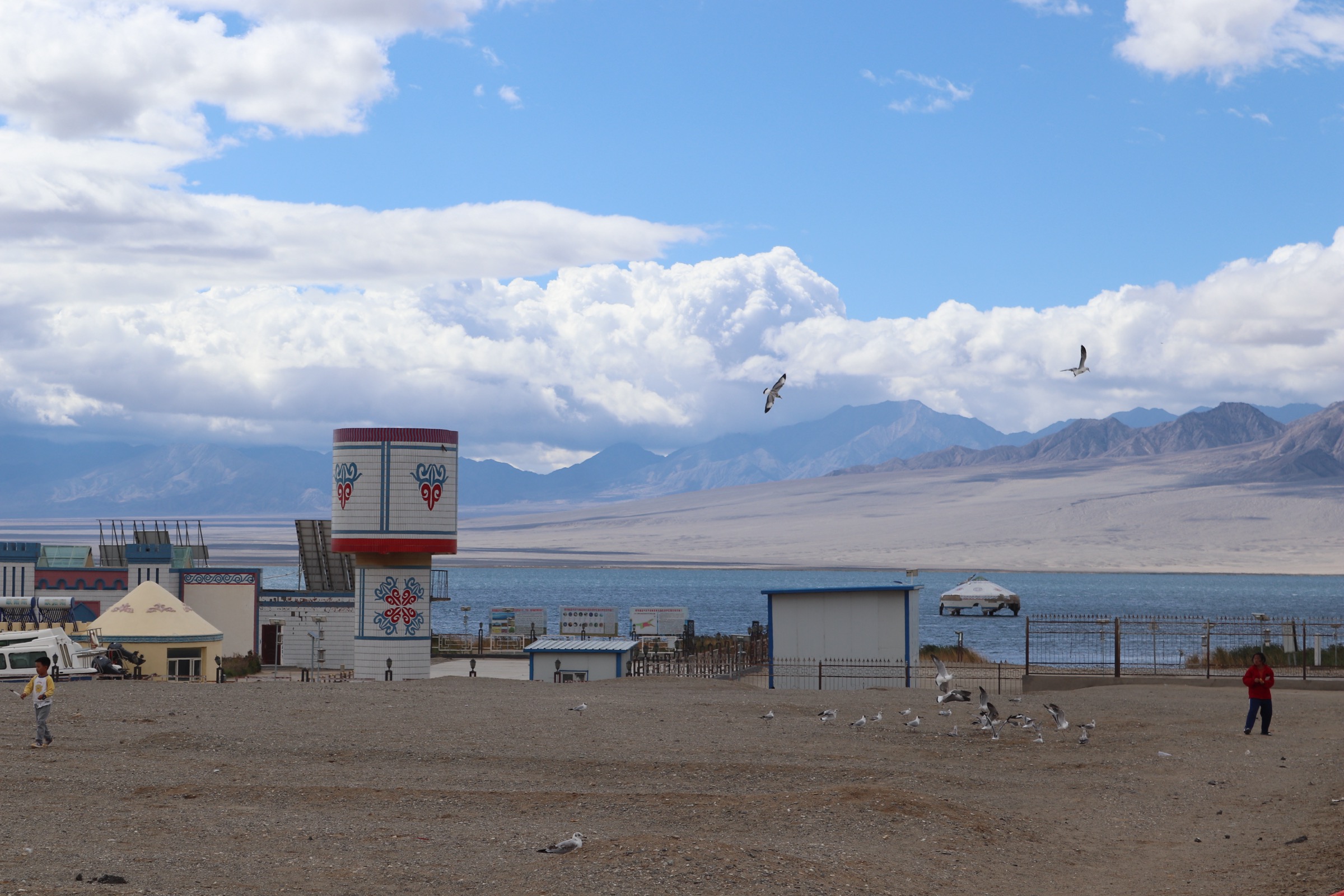
Ngoring Hu, at 610 km² and a depth of about 30 m, is the larger of the two great Yellow River source lakes and the lowest waypoint in this catalogue at about 4,272 m on its shore. The northern bay, on the same access road as the Niutou Bei, gives the most open lakeshore walking in the source country — a level turf-and-gravel strand backed by low rolling steppe with the Bayan Har crest visible on the southern horizon. The walking line begins where the access track first touches the shoreline below the Niutou Bei, follows the open beach east for 3–5 km depending on turnaround, and returns along the same line. Sections of the strand cross small ephemeral inlets and braided spring channels; in mid-summer these are easily forded.
There is no signed trailhead and no waymarking. Local guides from Madoi will identify the safest turnaround for the day’s conditions; without a guide, treat the line as a free-form lakeshore wander rather than a defined route. Bird life on the bay is the most concentrated in the region — bar-headed geese, brown-headed gulls and ruddy shelduck breed on the islands and shallows. The wider Sanjiangyuan core zone begins a short distance south of the lake; do not extend the walk inland from the shore.
Why it is essential
The Ngoring Hu northern lakeshore is the only longer walking line at the Yellow River source that is genuinely available without a Sanjiangyuan core-area permit, and the only foot route in this catalogue that gives sustained lakeshore time with the Bayan Har wall as a backdrop. It is the canonical complement to the brief Niutou Bei summit walk.
Equipment
- Sturdy walking shoes — wet ground at the inlets
- Trekking poles useful on uneven turf
- Windproof shell — lakeshore wind is constant
- Extra warm layer and hat regardless of season
- Sun protection — strong UV with reflection from water
- Water and full day’s food; no water sources off the shore
- Navigation backup (GPS with offline base map; no mobile signal)
- Headtorch in case the return runs late
- Altitude medication advisable
Hazards and notes
Altitude exposure is sustained — five hours above 4,250 m is enough to provoke acute mountain sickness in unacclimatised walkers. Weather changes rapidly; afternoon hail and thunderstorms occur even in July. The lake water is potable only after filtering and boiling and is in any case off-limits as the source of the Yellow River — do not drink directly from the shore. There is no mobile signal, no shelter and no easy retreat. The Sanjiangyuan core zone boundary lies a short distance inland from the southern shore; do not cross it. Drone use over the lake is restricted under the park rules.
External links
- Wikipedia — Ngoring Lake
- Wikipedia — Gyaring Lake
- Ramsar Sites Information Service — Zhaling-Eling Lakes
3. Bayan Har Pass — G214 stele cluster walk — 巴颜喀拉山口
Snapshot
Itinerary
Bayan Har Pass is the highest crossing on G214 between Xining and Yushu and the most photographed waypoint on the Yellow River–Yangtze watershed in Qinghai. The pass is broad and open; a single low lay-by holds the principal pass stele (Chinese “巴颜喀拉山口 海拔 4824米” with Tibetan parallel text), prayer-flag arrays strung between low concrete towers, and a small interpretive sign giving the watershed line. A short paved spur, perhaps 200 m long, runs from the lay-by to a low rise carrying additional prayer-flag installations and a more open view south toward the Yangtze drainage. A second spur, 300–400 m on the opposite side of the road, leads to a wind-power-station site marker and gives a wider open view back over the headwater plain.
Most visitors complete the cluster in 45–90 minutes including time at the stele. Bus passengers en route Xining–Jiegu typically get 15–20 minutes only and are restricted to the lay-by itself.
Why it is essential
Bayan Har Pass is the highest sanctioned roadside walk in this catalogue and the canonical waypoint on the Yellow River–Yangtze divide. The stele cluster is the single most-photographed location in the Bayan Har range and a non-negotiable stop on any G214 traverse.
Hazards and notes
The pass sits at about 4,824 m — the highest point in this entire catalogue and high enough that unacclimatised visitors routinely suffer acute mountain sickness within minutes of arrival. Walkers from Xining or from low-altitude flights into Yushu should treat the pass as a brief stop rather than a sustained walk. Wind is constant and frequently sandblasts the lay-by; ground blizzard can close the road without warning between October and May. Lightning in summer thunderstorms is a real risk in open country. Drone use is restricted in the wider Sanjiangyuan zone.
Equipment
- Standard hiking shoes or boots
- Windproof shell layer (constant wind)
- Warm mid-layer and hat regardless of season
- Gloves outside high summer
- Sun protection — UV at 4,800 m is extreme
- Water and snacks
- Altitude medication advisable for unacclimatised visitors
External links
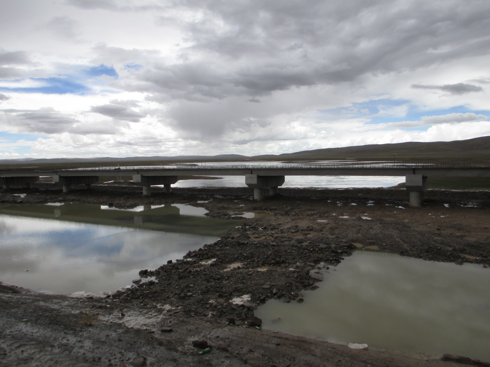
4. Madoi — Yellow River First Bridge heritage walk — 黄河第一桥
Snapshot
Itinerary
Madoi township is the first significant settlement on the Yellow River as it leaves the source lakes, and the bridge carrying G214 across the river at the township edge is the first road bridge on the entire Huang He — formally named the Yellow River First Bridge (黄河第一桥). The walking line is a simple riverbank loop: from the township river-front, walk west along the north bank for 600–800 m to the bridge approach, cross the bridge on the pedestrian footway (the river here is broad, braided and slow, perhaps 60 m wide at average flow), continue 400 m on the south-bank dirt track, and return across the same bridge or via the older crossing further upstream where conditions permit. Information panels at the bridge approach record the township’s altitude and the bridge’s commemorative status.
Most visitors combine the bridge walk with a brief riverside circuit on the south bank, where small shrines and prayer-flag installations mark the ceremonial first-crossing point. The walk is the lowest-altitude sanctioned stroll in this catalogue and the only one that begins from a township street rather than from a roadside lay-by.
Why it is essential
The First Bridge is the canonical heritage waypoint on the Yellow River source corridor — the first road crossing of the river that drains a quarter of China’s population — and the walk gives the only townside river-front in the headwaters country that is genuinely walkable without a vehicle. It is the natural acclimatisation walk on arrival in Madoi.
Equipment
- Standard hiking shoes
- Windproof layer
- Warm mid-layer
- Sun protection
- Water bottle
Hazards and notes
Altitude exposure begins immediately on arrival; the township sits at 4,260 m and walkers stepping off the overnight bus from Xining frequently experience acute mountain sickness on the first short walk. The riverbank in places is unfenced and the bridge footway is narrow with heavy freight traffic on the carriageway — keep to the inside of the rail and walk single file. The Madoi public-security checkpoint at the bridge approach may inspect visitor documents; carry the Chinese-passport or alien-permit equivalent at all times. Drone use over the bridge and the river is restricted.
External links
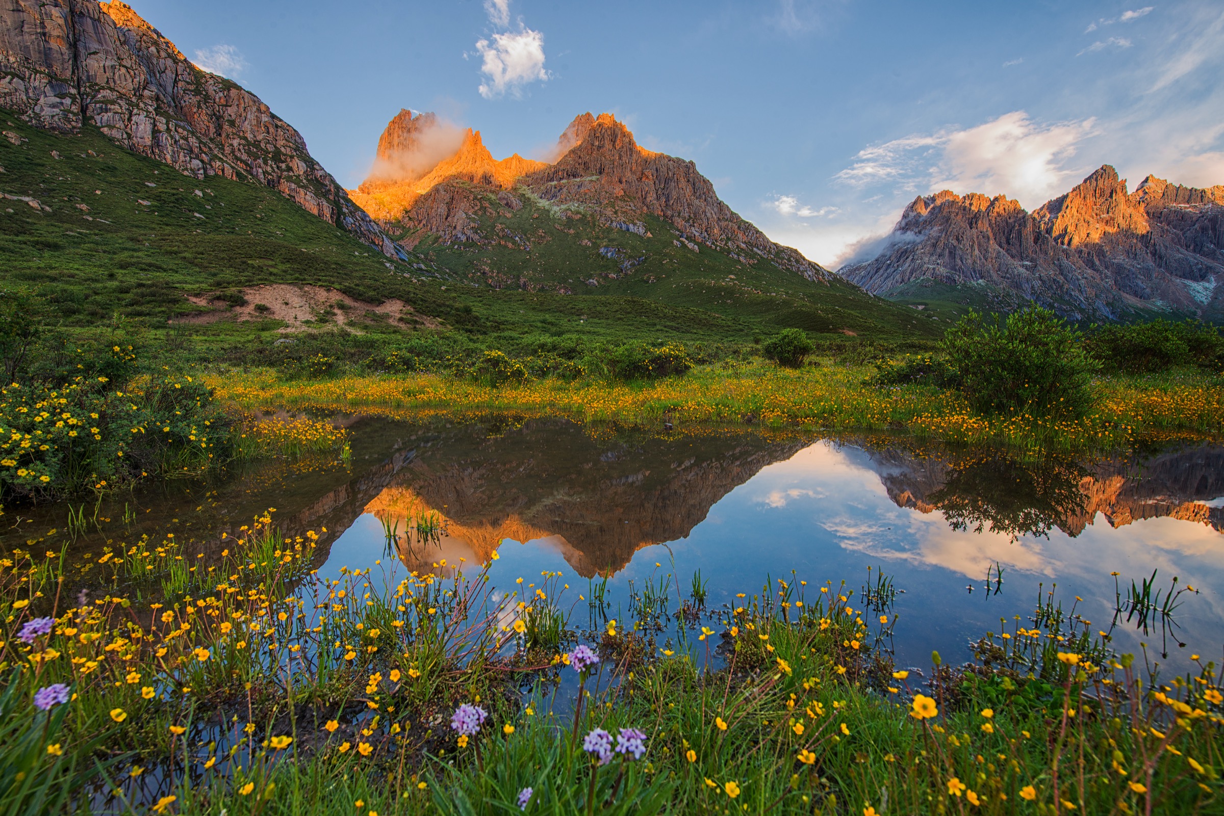
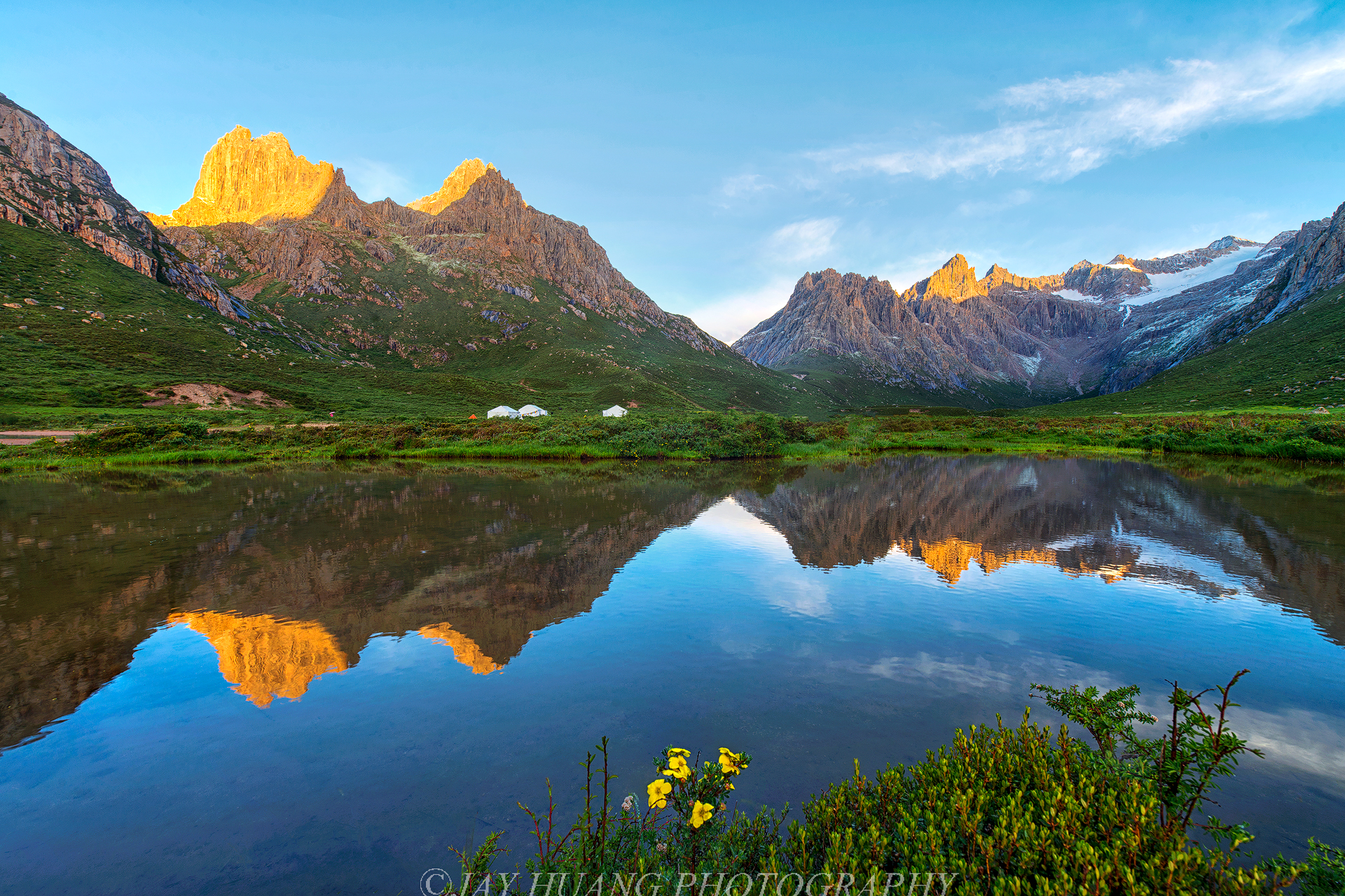
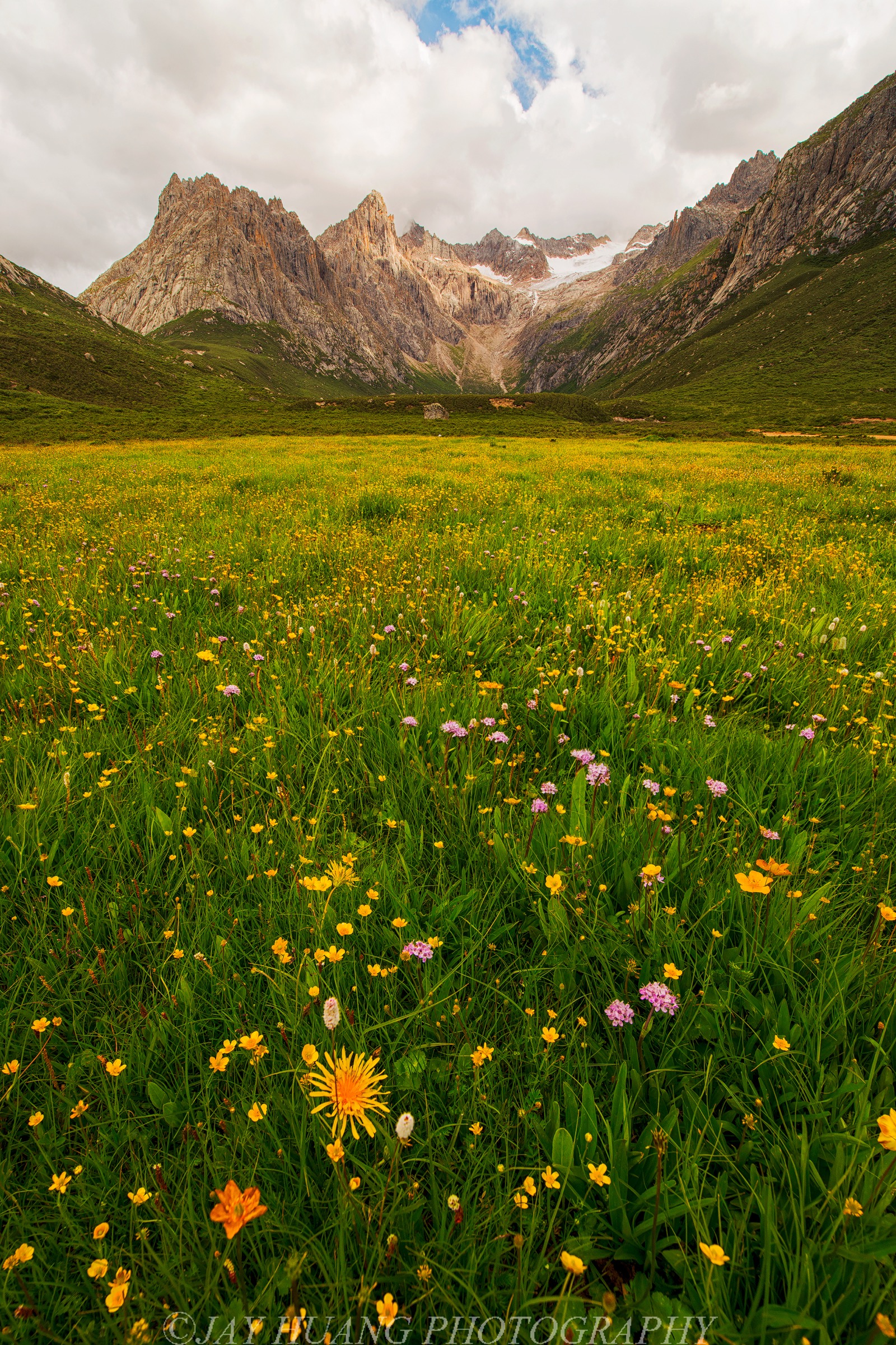
5. Nianbaoyuze — Yaonü Lake (closed) — 年保玉则 · 妖女湖
Snapshot
Itinerary
Nianbaoyuze (年保玉则, Tibetan Nyainpo Yutse, 5,369 m) is the principal massif of the eastern Bayan Har — a cluster of granite spires above 5,000 m holding a constellation of small lakes at 4,000–4,400 m, traditionally a Bön and Nyingma pilgrimage site and, until 2018, the most photographed walking destination in this part of Qinghai. The classic short option was the Yaonü Lake (妖女湖, “Demoness Lake”) out-and-back: from the geopark gate near Suo Hutuo Township, a graded track wound through wildflower meadows for 5–7 km to the lake, set in a glacial basin under the central spires. Total ascent was 300–500 m, total return distance 10–14 km, walking time 5–7 hours at altitude.
The geopark has been closed indefinitely to all tourism since April 2018, on a Jiuzhi County government order, citing ecological degradation from rising visitor numbers and damage to the alpine meadow surface. The closure is enforced at the access road and the former park gate; foot entry over the surrounding ridges is also formally prohibited under the Sanjiangyuan and provincial nature-reserve frameworks. There is no published reopening date as of June 2026.
Why it is essential
Yaonü Lake is the only walking destination in the eastern Bayan Har that achieves the classic Tibetan-Plateau combination of glacial spires, alpine lake and wildflower meadow on a one-day line — and the route is the historical reference point for any future Bayan Har hiking catalogue. It is included here for completeness and to document its current status, not as a current walking recommendation.
Equipment
- Not applicable while closure remains in force
Hazards and notes
The area is closed to all visitors as of June 2026 and has been since 2018. Attempting entry past the former gate, by foot or by vehicle, risks fine and removal under the Jiuzhi County and Sanjiangyuan reserve rules. The closure is well-enforced and is unlikely to lift in the short term. The 2018 closure followed sustained damage to the meadow surface by visitor traffic and overgrazing; ecological restoration is ongoing and the area’s official tourism portals have been taken down. Verify status with the Jiuzhi County tourism bureau before any travel into the wider Nianbaoyuze region.
External links
Missing data / follow-up work
- No official GPX or KML has been located for any of the five walks. The Sanjiangyuan National Park administration, the Golog and Yushu prefectural tourism portals and the Madoi county tourism bureau publish descriptive material only. On-site GPS capture is the only route to reliable route geometry.
- Hike 1 (Niutou Bei stele): the exact altitude of the stele platform is given variously between 4,580 m and 4,640 m in Chinese travel sources; 4,610 m is used here as the most commonly cited figure but should be confirmed on the ground.
- Hike 2 (Ngoring Hu lakeshore): the lakeshore turn-off from the Niutou Bei access road is unsigned and turnaround points vary between trip reports. Local guides from Madoi should be consulted for current safe extent.
- Hike 3 (Bayan Har Pass): the cited pass elevation of 4,824 m comes from Chinese road signage; alternative sources cite 4,749 m or 4,820 m. Treat as approximate.
- Hike 4 (Madoi First Bridge): the Madoi public-security checkpoint at the bridge approach has been variously reported as closed and as actively inspecting visitor documents; confirm in Xining before travel.
- Hike 5 (Nianbaoyuze Yaonü Lake): the closure is confirmed via the 2018 Jiuzhi County order and the original photographer’s 2015 note that the area was subsequently “closed indefinitely for rehabilitation”. No reopening date has been published; verify status with the Jiuzhi County tourism bureau before any future planning.
- No licence-compatible image has been located for Hikes 1, 2 or 3. Wikimedia Commons coverage of the Niutou Bei, Ngoring Hu and Bayan Har Pass is currently restricted to satellite imagery and to non-reusable third-party photographs.
- All distances and elevation figures for the unsignposted walks (Hikes 1, 2, 5) are estimates derived from satellite imagery and pre-closure trip reports. Treat as approximate until confirmed by ground survey.
- Permit reality at the Sanjiangyuan boundary: the core-zone boundary lies a short distance south of every walk in this catalogue and is patrolled. Always confirm walking lines with the Madoi or Jiuzhi tourism bureau before extending inland from the named monuments.