Regional overview
The central Fujian mountain belt sits between the coastal cities of the southeast and the Wuyi-Jiangxi watershed inland, threading together Danxia red-bed landscapes, narrow rock clefts, subtropical forest summits and several of Fujian’s highest peaks. Four scenic settings define the walking universe: the Danxia peak-and-lake country of Guanzhai Mountain in Liancheng County (Longyan), the World Heritage and UNESCO Global Geopark cliffs around Taining (Sanming), the slot-canyon corridor at Yong’an Taoyuan Cave further south, and the high forested summit country of Jinrao Mountain (Sanming) and Daiyun Mountain (Quanzhou).
The walking character is managed scenic-area hiking — stone steps, cliff stairways, plank roads, gorge boardwalks, temple courtyards, lake paths and shuttle-linked sectors — rather than open backcountry travel. Taining is part of the UNESCO China Danxia World Heritage serial property and a UNESCO Global Geopark, Daiyun Mountain is a national nature reserve and Jinrao Mountain (Baimading) is listed by Chinese sources as the highest point of Sanming Prefecture at 1,857.7 m. Published GPX is sparse for the entire region, so this guide pairs verified landmark and elevation data with conservative route descriptions and OpenStreetMap cross-checks rather than precise distance and ascent figures.
Best walking seasons are October through April for cool, dry conditions, with spring and autumn the clearest. Summer is hot, humid and storm-prone, with typhoon rain a real concern on gorge and cliff sections; the One-Line-Sky cleft at Taoyuan Cave can be unsafe in heavy runoff. Winter is generally mild at the lower Danxia scenic areas but fog, wind and occasional ice are normal on the Jinrao and Daiyun summits. The central Fujian belt connects east into the Wuyi and central Nanling ranges and south to the Danxia type locality at Danxia Shan in Guangdong.
Selection rationale
The five hikes cover the central Fujian mountain spectrum: Guanzhai Mountain’s Danxia peak-and-lake circuit, Taining’s World Heritage / UNESCO Global Geopark canyon walk, Yong’an Taoyuan Cave’s narrow-cleft scenic route, Jinrao Mountain’s high Sanming summit landscape and Daiyun Mountain’s nature-reserve summit route. The first three are partially verified scenic-area hikes with secure landmark data. The last two are retained as candidate entries because current public-route legality and exact trail geometry need stronger confirmation before publication as fully verified routes.
Summary table
| # | Hike | Country | Route type | Distance | Gain | Max elevation | Difficulty |
|---|---|---|---|---|---|---|---|
| 1 | Guanzhai Mountain and Shimen Lake scenic route | China | Loop / scenic-area traverse | Unresolved | Unresolved | 661 m | Moderate |
| 2 | Taining Zhaixia / Danxia canyon scenic walk | China | Out-and-back / loop | Unresolved | Unresolved | Unresolved | Moderate |
| 3 | Yong’an Taoyuan Cave and One-Line-Sky | China | Loop / out-and-back | Unresolved | Unresolved | Unresolved | Moderate |
| 4 | Jinrao Mountain / Baimading high route | China | Lift-assisted / out-and-back (candidate) | Unresolved | Unresolved | 1,857.7 m | Moderate–hard |
| 5 | Daiyun Mountain and Daiyun Temple summit route | China | Out-and-back (candidate) | Unresolved | Unresolved | 1,856 m | Hard |
1. Guanzhai Mountain and Shimen Lake scenic route
Snapshot
Itinerary
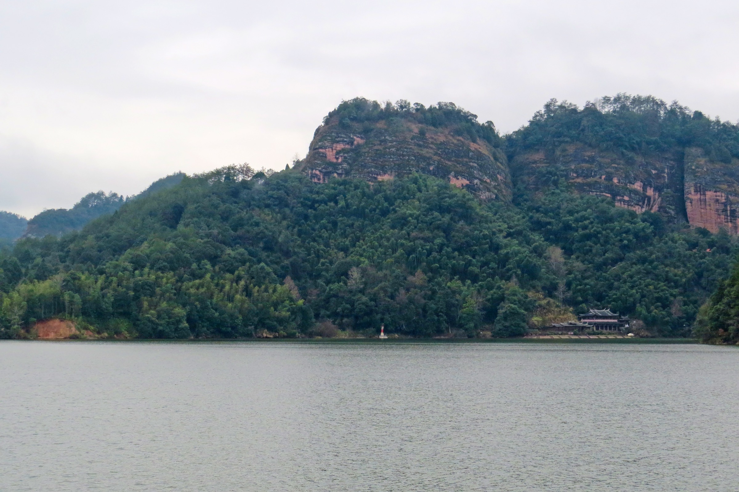
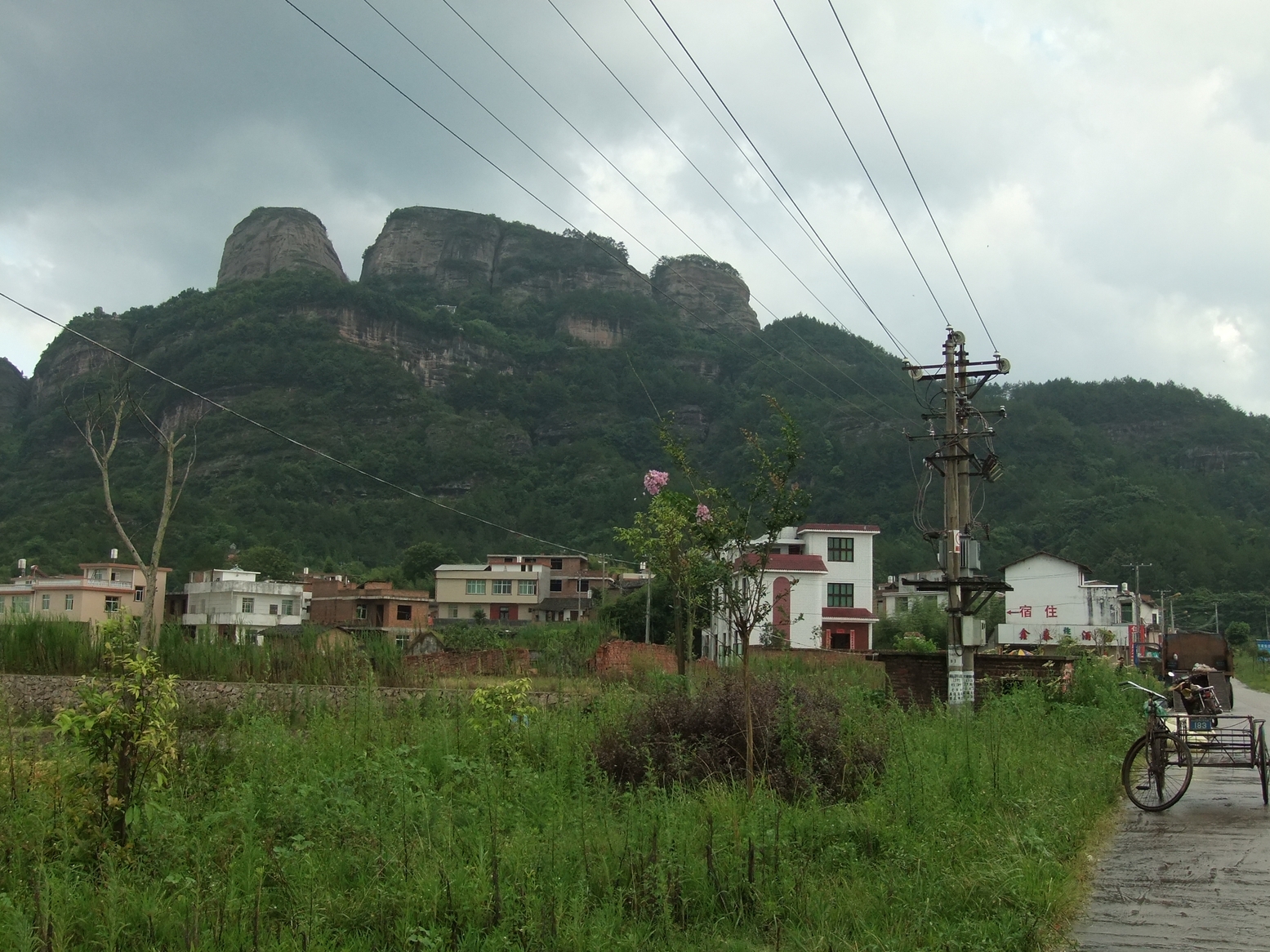
The walk climbs through the developed Guanzhai Mountain scenic area, threading red sandstone cliffs, stone-step staircases, temples and named peaks before linking — where open — toward the Shimen Lake / lower scenic-area sections. The wider scenic complex covers Guanzhai Mountain, Shimen Lake, Zhuzhai and Jiulong Lake, and the exact day-circuit depends on which combination of mountain paths, lake walkways and boat services are currently in operation. Confirm the open route on the gate-level scenic-area map before starting.
Why it is essential
Guanzhai Mountain is one of central Fujian’s best-known Danxia mountain landscapes — its main peak rises sharply from low farmland, the scenic area’s combined red-rock and lake character is unusual among Chinese Danxia sites, and the route is the most accessible way to walk the southern half of the central Fujian belt without committing to a remote nature-reserve summit.
Equipment
Grippy walking shoes, 1.5–2 L water, a rain shell, sun hat, sunscreen, snacks and an offline map. Trekking poles help on long stair descents but can be awkward on the narrowest steps.
Hazards and notes
Wet stone steps, cliff-edge viewpoints, heat, thunderstorms and crowding are the main hazards. If combining the walk with Shimen Lake boat transport, confirm boat operation and last-departure times before starting the circuit. Stay on signed scenic-area paths.
GPX / route file
| Source | URL | Format | Notes |
|---|---|---|---|
| OpenStreetMap — Guanzhai Mountain area | openstreetmap.org | Map / search | OSM data is ODbL; landmark cross-check only — no GPX found |
| Guanzhai Mountain overview (Chinese Wikipedia) | zh.wikipedia.org | Secondary overview | Elevation and landmark context only; no route file |
Further reading
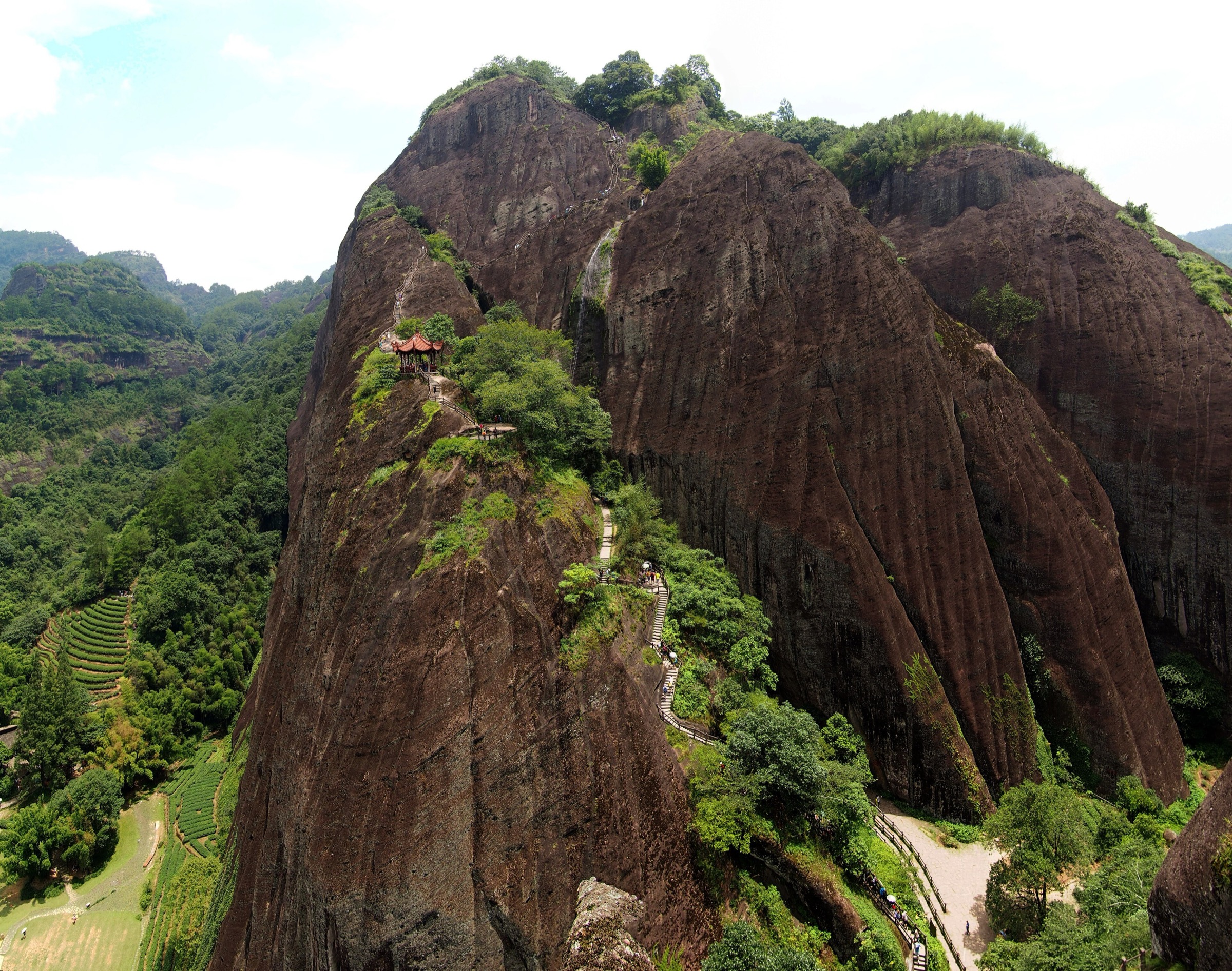
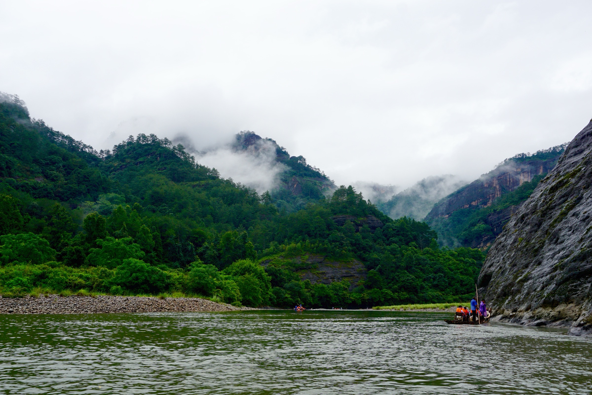
2. Taining Zhaixia / Danxia canyon scenic walk
Snapshot
Itinerary
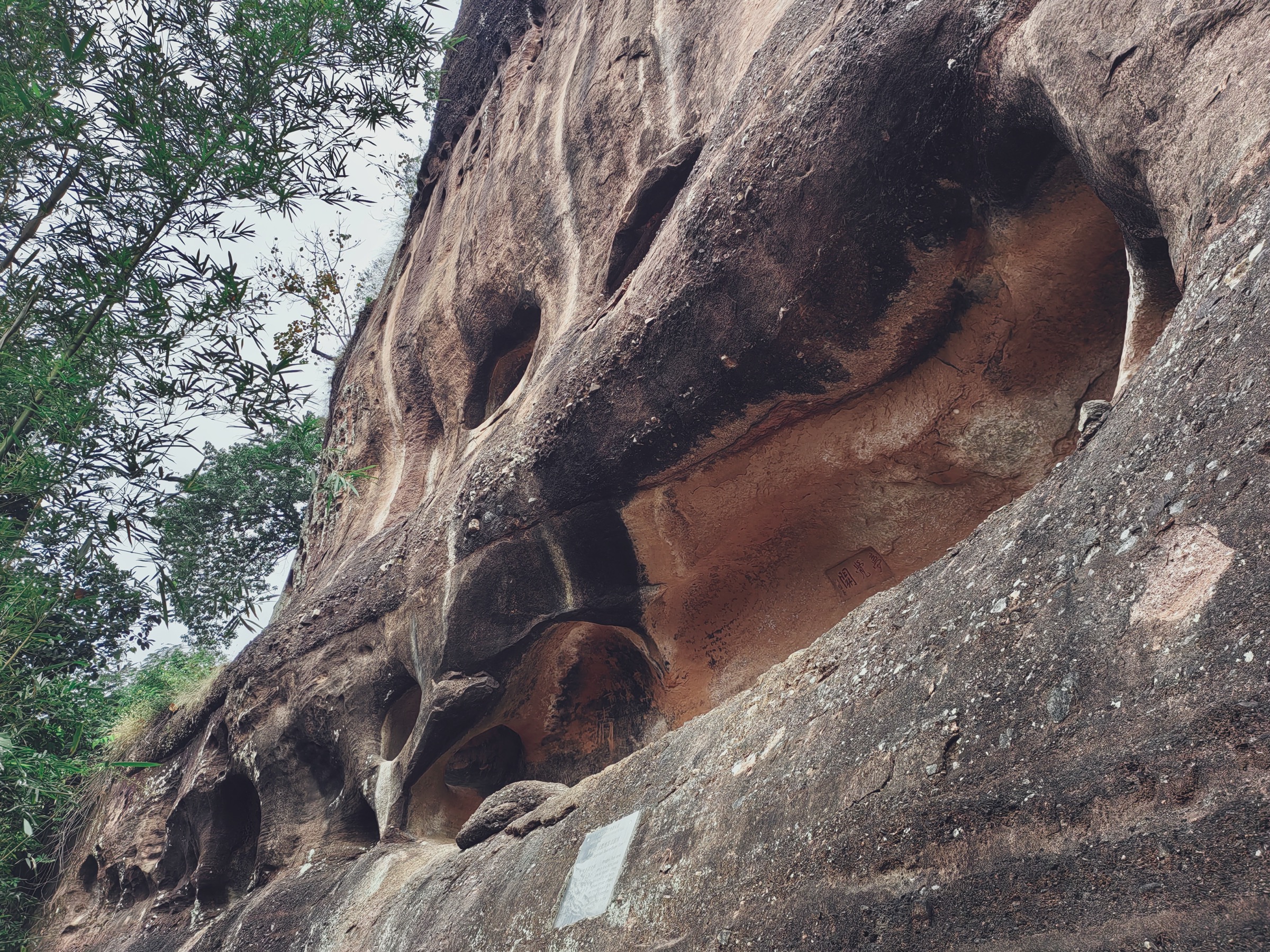
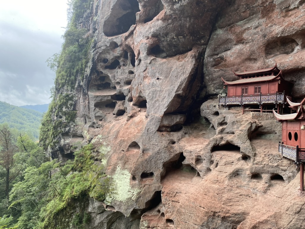
Use the signed Taining Danxia / Zhaixia-style canyon walking route rather than attempting a remote traverse. The practical day walk follows developed paths through red cliffs, narrow ravines, forested slopes and viewpoint platforms, with total length dependent on the currently open scenic-area circuit. Ganlu Temple — built directly into a Danxia cliff — is the most recognisable single sight along the route.
Why it is essential
Taining is both a UNESCO Global Geopark and part of the UNESCO China Danxia World Heritage serial property. It is central Fujian’s internationally recognised red-bed landscape and one of the strongest single geological selections in the region — the obvious counterpart to Danxia Shan in Guangdong and a natural Wuyi-area extension.
Equipment
Walking shoes with grip, waterproof layer, water, food, sun protection and an offline map. Trekking poles are optional but can be awkward on the narrowest stair sections.
Hazards and notes
Gorge routes can close after rain or rockfall. Wet steps, cliff viewpoints, heat and thunderstorms are the main hazards. Stay on signed scenic-area paths and respect any temporary closures.
GPX / route file
| Source | URL | Format | Notes |
|---|---|---|---|
| OpenStreetMap — Taining Zhaixia Grand Canyon | openstreetmap.org | Map / search | OSM data is ODbL; landmark cross-check only — no GPX found |
| UNESCO — China Danxia World Heritage | whc.unesco.org | World Heritage source page | Landscape verification only; not a route file |
| Taining Global Geopark overview (Chinese Wikipedia) | zh.wikipedia.org | Secondary overview | Geopark context; no route file |
Further reading
3. Yong’an Taoyuan Cave and One-Line-Sky
Snapshot
Itinerary
The walk uses the Taoyuan Cave scenic-area path system, focusing on the red-cliff gorge, historical fortification remains and the famous One-Line-Sky cleft. Chinese overview sources describe the cleft as roughly 127 m long, around 90 m high and only 0.4–1.2 m wide, with 206 steps — narrow enough that walkers with packs sometimes need to turn sideways.
Why it is essential
Taoyuan Cave adds a compact but dramatic rock-cleft route to the central Fujian catalogue. It is culturally and geomorphologically distinct from the Danxia walks at Guanzhai and Taining while still fitting the region’s red-cliff scenic-area character.
Equipment
Grippy shoes, light waterproof layer, water and sun protection. Avoid bulky packs in narrow cleft sections — slim profiles only.
Hazards and notes
The One-Line-Sky passage is narrow and can be slippery, crowded or unsuitable for claustrophobic walkers. Rockfall, wet steps and storm runoff are the main hazards. Confirm whether all cave and cleft sections are open before starting.
GPX / route file
| Source | URL | Format | Notes |
|---|---|---|---|
| OpenStreetMap — Yong’an Taoyuan Cave | openstreetmap.org | Map / search | OSM data is ODbL; landmark cross-check only — no GPX found |
| Taoyuan Cave, Yong’an overview (Chinese Wikipedia) | zh.wikipedia.org | Secondary overview | One-Line-Sky cleft geometry; no route file |
Further reading
4. Jinrao Mountain / Baimading high route
Snapshot
Itinerary
The candidate route uses the developed Jinrao Mountain high scenic area and summit-side boardwalks or paths where open, aiming for the Baimading / Jinrao high point. Exact walking distance, gain and the legal walking line were not verified in this pass, so this entry should be treated as a planning target rather than a turn-by-turn description.
Why it is essential
Jinrao Mountain is listed as the highest point of Sanming Prefecture and one of Fujian’s major high summits at 1,857.7 m. It gives the central Fujian catalogue a high-elevation objective beyond the lower Danxia scenic walks, and pairs naturally with Taining as a two-day Sanming combination.
Equipment
Mountain hiking equipment: sturdy shoes or boots, warm layer, waterproof and windproof shell, water, food, offline map and headtorch. In winter, microspikes may be needed if ice is reported on the upper boardwalks.
Hazards and notes
This route should not be treated as a fully verified hiking line until current scenic-area access and the legal walking path are confirmed on arrival. Fog, high wind, cold, cableway closure and wet steps are the main practical hazards.
GPX / route file
| Source | URL | Format | Notes |
|---|---|---|---|
| OpenStreetMap — Jinrao Mountain area | openstreetmap.org | Map / search | OSM data is ODbL; landmark cross-check only — no GPX found |
| Fujian prefectural high-point list (Chinese Wikipedia) | zh.wikipedia.org | Secondary overview | Elevation context; no route file |
Further reading
5. Daiyun Mountain and Daiyun Temple summit route
Snapshot
Itinerary
The proposed objective is the Daiyun Mountain main summit area and Daiyun Temple from the Dehua side. Chinese overview sources identify Daiyun Mountain as the main peak of the Daiyun range, 1,856 m high, and a national nature reserve. Public hiking access, the exact route and whether summit walking is permitted without reserve approval were not verified in this pass.
Why it is essential
Daiyun Mountain is one of Fujian’s major high summits and a defining range name for the eastern half of the central-Fujian uplands. It is included as a high-priority candidate to flag the high-elevation half of the region, not as a publication-ready route.
Equipment
Mountain hiking equipment: sturdy boots, waterproof shell, warm layer, navigation backup, water, food, headtorch and an emergency layer. Winter traction may be needed if ice is present.
Hazards and notes
This entry needs legal-access verification before use. Nature-reserve restrictions, unsigned tracks, fog, thunderstorms, leeches and ticks in season, and poor mobile signal are the likely planning issues. Do not use unofficial reserve shortcuts.
GPX / route file
| Source | URL | Format | Notes |
|---|---|---|---|
| OpenStreetMap — Daiyun Mountain area | openstreetmap.org | Map / search | OSM data is ODbL; landmark cross-check only — no GPX found |
| Daiyun Mountain overview (Chinese Wikipedia) | zh.wikipedia.org | Secondary overview | Summit elevation and nature-reserve status; no route file |
Further reading
Further reading
| Source | URL |
|---|---|
| UNESCO — China Danxia World Heritage | whc.unesco.org |
| UNESCO Global Geoparks list | en.wikipedia.org |
| Guanzhai Mountain overview (Chinese Wikipedia) | zh.wikipedia.org |
| Taining Global Geopark overview (Chinese Wikipedia) | zh.wikipedia.org |
| Taoyuan Cave, Yong’an overview (Chinese Wikipedia) | zh.wikipedia.org |
| Fujian prefectural high-point list (Chinese Wikipedia) | zh.wikipedia.org |
| Daiyun Mountain overview (Chinese Wikipedia) | zh.wikipedia.org |
| Wikimedia Commons — Taining County | commons.wikimedia.org |