Regional overview
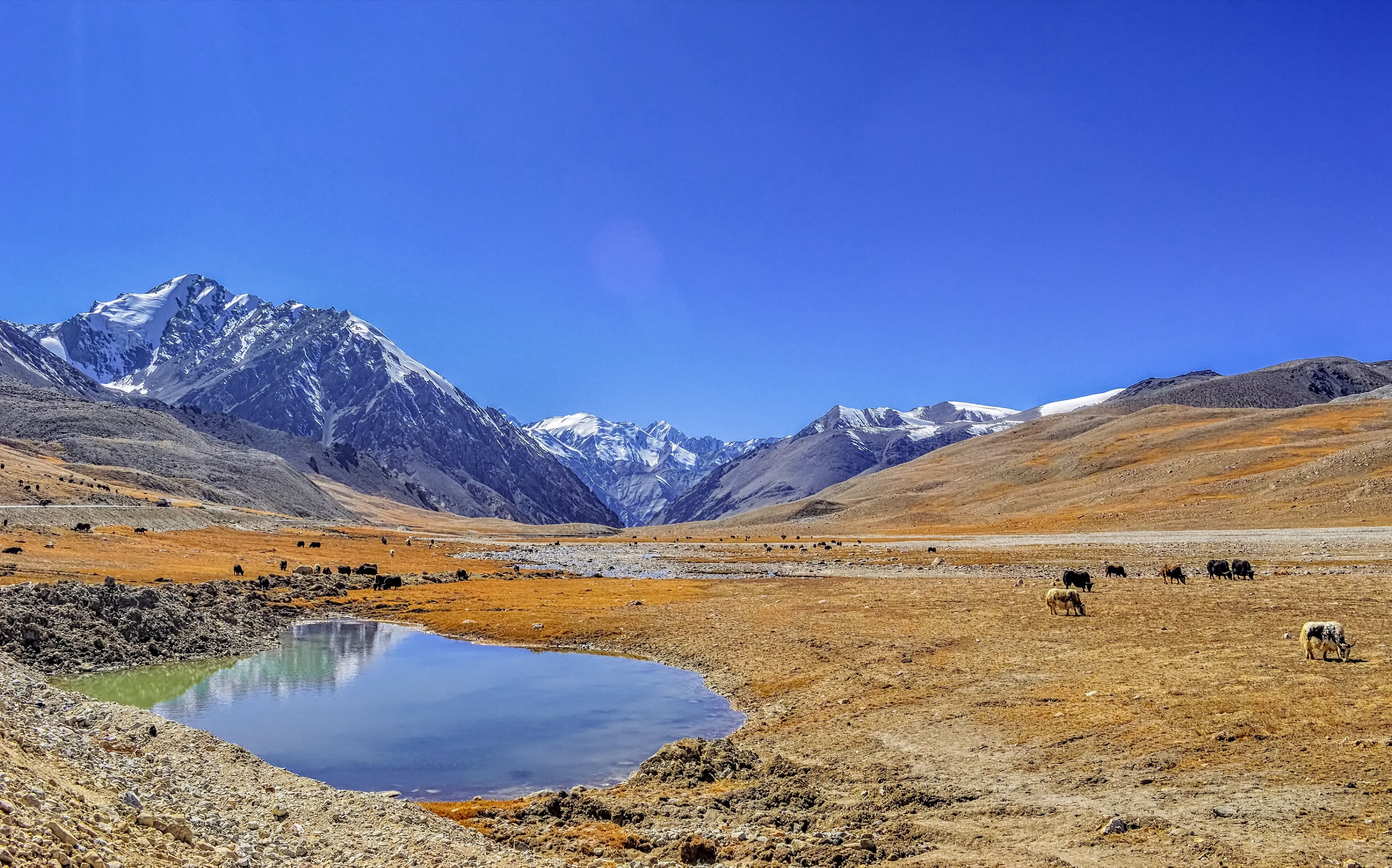
The Changbai / Manchurian Mountains are a volcanic, forested highland on the China-North Korea border, centred on Changbai Mountain / Paektu and Heaven Lake. The walking character is unusual for a mountain catalogue: access to the highest areas is tightly managed through north, west, and south scenic areas, with buses, time-slot reservations, stairways, plank roads, viewpoints, and seasonal closures. Below the crater rim, the region includes waterfall paths, hot springs, canyon boardwalks, lava and forest features, and deep winter snow-forest landscapes such as Laolike Lake.
Summer and autumn are the main hiking seasons. The North and West scenic areas are generally the standard visitor bases; the South Slope is more restricted and is reported by travel sources as open only seasonally because of ecological protection. Winter can be beautiful but severe: high wind, ice, extreme cold, and sudden scenic-area closures are normal planning risks.
Selection rationale
The five hikes below balance the iconic Tianchi crater-lake viewpoints, Changbai Waterfall, the West Slope stair and canyon walking route, the less-developed South Slope, a lower-elevation forest route, and a broader Manchurian snow-forest lake walk. Route files are scarce and, where Wikiloc exists, the tracks appear to include long vehicle transfers rather than clean walking-only GPS data. Those sources are recorded as source maps only.
Summary table
| # | Hike | Country | Route type | Distance | Gain | Max elevation | Difficulty | Photo status |
|---|---|---|---|---|---|---|---|---|
| 1 | North Slope Tianchi, Changbai Waterfall and Julong Hot Spring Walk | China | Shuttle-assisted scenic-area walk | Approx. 4-8 km walking; exact total unresolved | limited by shuttles | Approx. 2,600 m rim viewpoint; exact walking high point unresolved | Moderate | Commons image verified |
| 2 | West Slope 1,442 Steps, Jinjiang Grand Canyon and Wangchi | China | Shuttle-assisted stair/plank-road route | Approx. 6-7 km walking from sourced segments | Approx. 250-450 m | Approx. 2,470 m at West Slope Tianchi viewpoint | Moderate-hard | Commons image verified |
| 3 | South Slope Tianchi, Yalu River Grand Canyon and Yuehua Twin Waterfalls | China | Shuttle-assisted viewpoint and short walks | Tianchi rim area above 2,400 m | Moderate-hard | Broad Commons image verified | ||
| 4 | Underground Forest, Green Deep Pool and Small Tianchi | China | Shuttle-assisted forest and lake walk | Approx. 3-5 km walking; exact total unresolved | Easy-moderate | No specific licence-compatible image verified | ||
| 5 | Laolike Lake Snow-Forest Walk | China | Out-and-back / local circuit variants | Candidate only | No licence-compatible image verified |
1. North Slope Tianchi, Changbai Waterfall and Julong Hot Spring Walk
Snapshot
Itinerary
The classic North Slope day uses the park’s internal transport to reach the Tianchi transfer centre and the upper crater-lake viewpoint, then descends through the Changbai Waterfall and Julong Hot Spring area. Additional short walks commonly include Green Deep Pool, Small Tianchi, and Underground Forest if time and access allow.
This is not an open ridgeline hike. It is a managed scenic-area walking day with short pedestrian sections between shuttle stops. The Changbai Mountain Grand Waterfall is verified by Jilin government information as the only outlet of Tianchi and about 68 m high; older trails close to the waterfall are reported closed for safety and environmental protection.
Why it is essential
The North Slope is the most established Changbai visitor route and gives the catalogue the core volcanic sequence: Heaven Lake, outlet waterfall, hot springs, lava terrain, and forest.
Equipment
Warm layer, waterproof/windproof shell, gloves and hat outside midsummer, walking shoes with grip, water, food, sun protection, and traction in icy periods.
Hazards and notes
High wind, fog, ice, lightning, and temporary closures are common risks. Heaven Lake visibility is not guaranteed. Stay on open paths; closed waterfall-side trail relics should not be entered.
Photos
| Image | Source | Author | Licence | Reuse notes | Attribution |
|---|---|---|---|---|---|
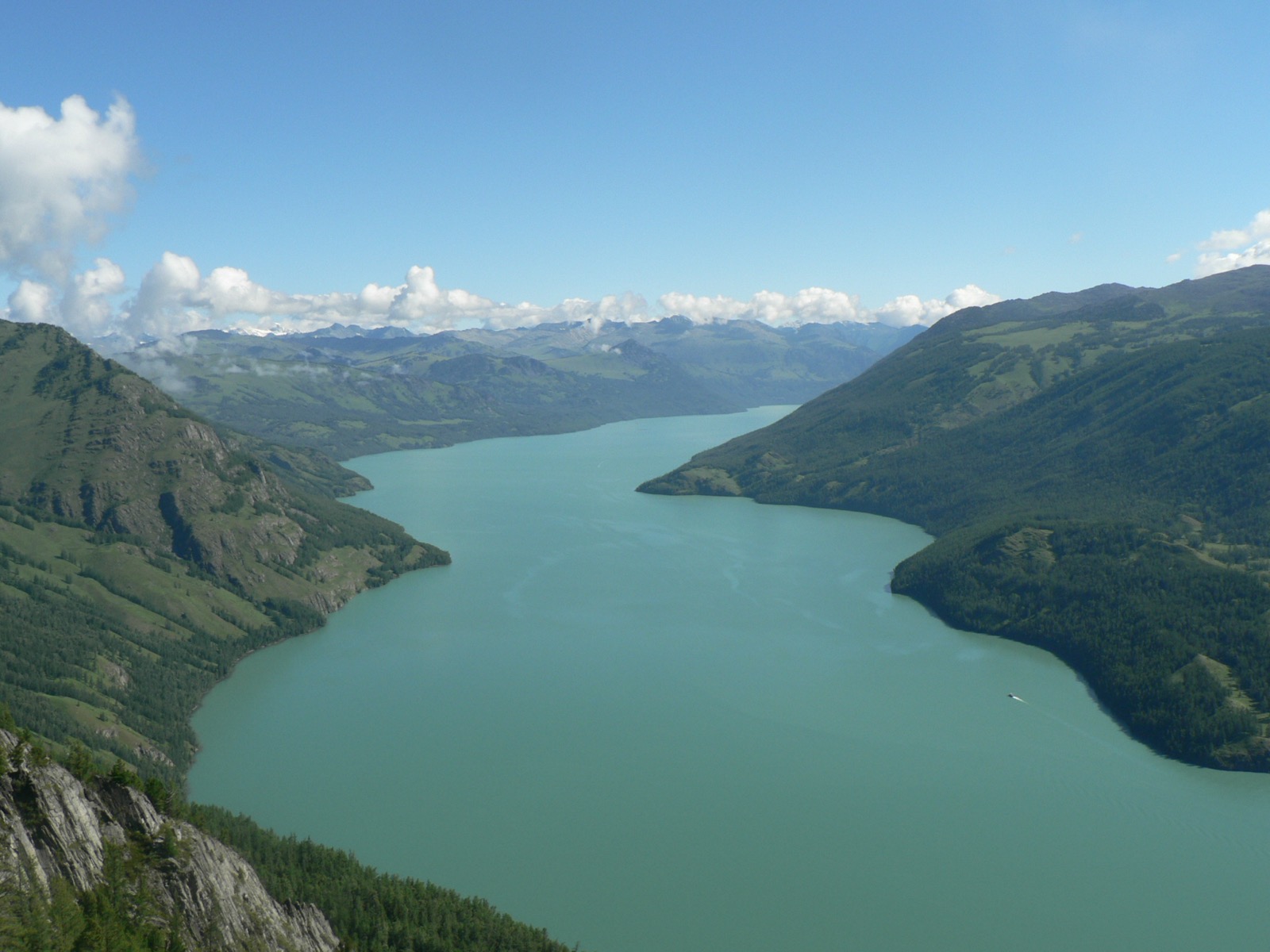
| Heaven Lake - Changbai Mountain (Aerial photograph) | commons.wikimedia.org | Xu Yinhua | CC BY-SA 4.0 | Broad Tianchi image; commercial reuse and modification appear allowed with attribution and share-alike | “Heaven Lake - Changbai Mountain (Aerial photograph)” by Xu Yinhua, CC BY-SA 4.0, via Wikimedia Commons |
GPX / KML links
| Source | URL | Format | Licence / terms | Reuse status |
|---|---|---|---|---|
| Wikiloc: Changbai Mountain Tianchi (North Slope) | wikiloc.com | Route page / GPS track via Wikiloc | Wikiloc terms apply | Source-map only; track appears to include long vehicle transfer and should not be treated as walking-only geometry |
| OpenStreetMap search: Changbai North Slope | openstreetmap.org | Map/search | OSM data is ODbL | Geometry cross-check only |
| Jilin government: Changbai Mountain Grand Waterfall | gojilin.gov.cn | Official attraction page | No route-file licence found | Waterfall and closure context only |
External links
- Jilin government — Changbai Mountain Grand Waterfall
- LoongWander — Changbai Mountain route, ticket and access summary
- China Xian Tour — Changbai recommended North Slope route and hiking notes
- Wikiloc — North Slope source map
2. West Slope 1,442 Steps, Jinjiang Grand Canyon and Wangchi
Snapshot
Itinerary
After entering the West Scenic Area, take the scenic bus to the Tianchi parking area and climb the 1,442-step stairway to the West Slope crater-lake viewpoint. The West Slope is valued for an open view over Heaven Lake. After descending, continue by scenic transport and short walks to Jinjiang Grand Canyon, where a plank-road route follows volcanic canyon scenery, and to Wangchi if open.
Why it is essential
The West Slope provides the clearest stair-climb element in the managed Changbai system and combines Tianchi with canyon and alpine-meadow scenery. It is the most hike-like of the standard crater-lake approaches.
Equipment
Hiking shoes, warm and waterproof layers, gloves/hat outside midsummer, water, snacks, sun protection, and traction if ice is possible.
Hazards and notes
The stairway is exposed to wind and weather. The route can close in storms, heavy rain, snow, or low visibility. The West and North scenic-area ticketing/combined-entry rules should be checked before travel.
Photos
| Image | Source | Author | Licence | Reuse notes | Attribution |
|---|---|---|---|---|---|
| Heaven Lake, Changbai | commons.wikimedia.org | Charlie fong at Chinese Wikipedia | Public domain | Commercial reuse and modification appear allowed; public-domain dedication stated on Commons | “Heaven Lake, Changbai” by Charlie fong, public domain, via Wikimedia Commons |
GPX / KML links
| Source | URL | Format | Licence / terms | Reuse status |
|---|---|---|---|---|
| Wikiloc: Heavenly Lake of Changbaishan (West Slope) | wikiloc.com | Route page / GPS track via Wikiloc | Wikiloc terms apply | Source-map only; track appears to include long vehicle transfer and should not be treated as walking-only geometry |
| OpenStreetMap search: Changbai West Slope | openstreetmap.org | Map/search | OSM data is ODbL | Geometry cross-check only |
External links
- LoongWander — West Slope route with 1,442 steps, 2 km Jinjiang Grand Canyon plank road and 3 km Wangchi round trip
- China Xian Tour — West Slope route and 900 m stairway note
- Trip.com — West Slope note citing 1,442 steps and 2,470 m viewpoint
- Wikiloc — West Slope source map
3. South Slope Tianchi, Yalu River Grand Canyon and Yuehua Twin Waterfalls
Snapshot
Itinerary
The South Slope is the more primitive and restricted Chinese-side approach to Changbai. Consulted travel sources describe a route focused on Tianchi plus Yalu River Grand Canyon, Yuehua Twin Waterfalls, and alpine wetland scenery. Unlike the North and West areas, this route has fewer facilities and more limited opening, so it should be treated as a controlled scenic-area day rather than a freely available trail.
Why it is essential
The South Slope represents the quieter and more ecologically sensitive side of Changbai: high volcanic terrain, borderland forest, canyon scenery, and a different angle on Heaven Lake.
Equipment
Full mountain day-walking kit: boots, warm and waterproof layers, gloves/hat, water, food, sun protection, headlamp, and navigation backup even though movement is likely controlled by scenic-area access.
Hazards and notes
Seasonal closure, daily visitor limits, storms, fog, cold wind, limited facilities, and border/protected-area restrictions are the main concerns. A local guide or organised access may be advisable if independent transport and current rules are unclear.
Photos
| Image | Source | Author | Licence | Reuse notes | Attribution |
|---|---|---|---|---|---|
| Heaven Lake - Changbai Mountain (Aerial photograph) | commons.wikimedia.org | Xu Yinhua | CC BY-SA 4.0 | Broad Tianchi image; commercial reuse and modification appear allowed with attribution and share-alike | “Heaven Lake - Changbai Mountain (Aerial photograph)” by Xu Yinhua, CC BY-SA 4.0, via Wikimedia Commons |
GPX / KML links
| Source | URL | Format | Licence / terms | Reuse status |
|---|---|---|---|---|
| OpenStreetMap search: Changbai South Slope | openstreetmap.org | Map/search | OSM data is ODbL | Geometry cross-check only |
| LoongWander: Changbai Mountain | loongwander.com | Source page / route guide | No route-file licence found | Access and season cross-check only |
External links
- LoongWander — South Slope opening and visitor-limit note
- China Xian Tour — South Slope route context and June-October opening note
4. Underground Forest, Green Deep Pool and Small Tianchi
Snapshot
Itinerary
This lower North Slope walking day focuses on Changbai’s forest and water features rather than the crater rim. Short paths visit Green Deep Pool, Small Tianchi, and the Underground Forest / lava-collapse forest area. It can be combined with the North Slope Tianchi day if time is sufficient, but it is useful as a separate lower-elevation walking option when high wind or cloud prevents a crater-lake view.
Why it is essential
Changbai is not only a crater lake. The lower forest route represents the Manchurian mountain forest, volcanic landforms, pools, and dense vegetation that define the range below the alpine zone.
Equipment
Walking shoes, rain layer, warm layer, water, snacks, sun protection, and traction in icy periods.
Hazards and notes
Wet boardwalks, snow or ice, and closures after storms are the main issues. Follow the marked scenic-area paths; forest off-trail walking may damage protected vegetation and violate park rules.
Photos
Photo status: No licence-compatible image found in this pass.
| Image | Source | Author | Licence | Reuse notes | Attribution |
|---|---|---|---|---|---|
| Unresolved | commons.wikimedia.org | Unresolved | Unresolved | Search target recorded; no individual reusable image candidate verified | Unresolved |
GPX / KML links
| Source | URL | Format | Licence / terms | Reuse status |
|---|---|---|---|---|
| OpenStreetMap search: Changbai Underground Forest | openstreetmap.org | Map/search | OSM data is ODbL | Geometry cross-check only |
| LoongWander: North Slope lower stops | loongwander.com | Source page / route guide | No route-file licence found | Timing and stop verification only |
External links
- LoongWander — North Slope one-day route with Underground Forest, Green Deep Pool and Small Tianchi timings
- China Xian Tour — North Slope route context
5. Laolike Lake Snow-Forest Walk
Snapshot
Itinerary
The publication-ready route line was not verified in this pass. Laolike Lake is included as a Changbai-Manchurian snow-forest target because Jilin sources identify it as a scenic spot in Yanbian and recent wildlife reporting places wild sables in the forest around the lake. A Wikiloc page for “Frozen Laolike Lake” exists, but the walking statistics were not captured clearly enough to publish.
Why it is essential
Laolike Lake broadens the Changbai entry beyond the highly managed crater-lake slopes. It represents the winter Manchurian forest character: deep snow, cold woodland, and quieter lake terrain.
Equipment
Winter walking equipment if snow is present: insulated boots, traction or snowshoes as conditions require, down or synthetic warm layer, shell, gloves, hat, headlamp, hot drink, food, map/GPS, and emergency warmth. In summer, standard hiking kit is still required.
Hazards and notes
Deep snow, cold injury, unclear trail lines, limited daylight, and transport uncertainty are the key unresolved issues. Do not publish this as a confirmed independent route until local access and exact trail statistics are verified.
Photos
Photo status: No licence-compatible image found in this pass.
| Image | Source | Author | Licence | Reuse notes | Attribution |
|---|---|---|---|---|---|
| Unresolved | commons.wikimedia.org | Unresolved | Unresolved | Search target recorded; no individual reusable image candidate verified | Unresolved |
GPX / KML links
| Source | URL | Format | Licence / terms | Reuse status |
|---|---|---|---|---|
| Wikiloc: Frozen Laolike Lake | wikiloc.com | Route page / GPS track via Wikiloc | Wikiloc terms apply | Candidate source-map only; stats not fully verified in this pass |
| OpenStreetMap search: Laolike Lake | openstreetmap.org | Map/search | OSM data is ODbL | Geometry cross-check only |
External links
- Wikiloc — “Frozen Laolike Lake” route source
- Jilin government — South Korean tourists and Laolike Lake scenic spot context
- Jilin government — wildlife around Laolike Lake forest
External links
| Source | URL |
|---|---|
| Jilin government — Changbai Mountain Grand Waterfall | gojilin.gov.cn |
| Jilin government — Laolike Lake scenic spot context | gojilin.gov.cn |
| Jilin government — wildlife around Laolike Lake forest | gojilin.gov.cn |
| LoongWander — Changbai Mountain route, ticket and access summary | loongwander.com |
| China Xian Tour — Changbai recommended routes and hiking notes | chinaxiantour.com |
| Trip.com — West Slope note citing 1,442 steps and 2,470 m viewpoint | trip.com |
| Wikiloc — Changbai Mountain Tianchi (North Slope) | wikiloc.com |
| Wikiloc — Heavenly Lake of Changbaishan (West Slope) | wikiloc.com |
| Wikiloc — Frozen Laolike Lake | wikiloc.com |