Regional overview
La Palma is the steepest and most trail-defined of the Canary Islands, with day hikes running from the Caldera de Taburiente basin and rim to Cumbre Vieja volcanoes, laurel forest, water galleries, ravines, and high observatory roads. This catalogue unit centres on Caldera de Taburiente but includes the island’s adjacent essential day hikes because they form the recognised La Palma mountain walking circuit.
The walking character is volcanic, ravine-based, forested in the northeast, and often access-sensitive. Flash flooding, landslides, tunnel conditions, road/taxi logistics, heat, cloud, wind, and official trail closures are central planning issues. Route/source status was checked in this pass on 2026-06-12; the official La Palma footpath status portal must be checked again before publication or travel.
Selection rationale
The five hikes cover the national-park basin route, the classic Cumbre Vieja volcano traverse, the high Caldera rim, a laurisilva/Somada Alta forest loop, and the Marcos y Cordero water-gallery route to Los Tilos.
Summary table
| # | Hike | Country | Route type | Distance | Gain | Max elevation | Difficulty |
|---|---|---|---|---|---|---|---|
| 1 | Caldera de Taburiente: Los Brecitos - Barranco de Las Angustias | Spain | Point-to-point | 12.5 km official; 13.5 km mapped variant | 417 m secondary | 1,148 m secondary | High official / Moderate secondary |
| 2 | Ruta de los Volcanes / GR 131 day section | Spain | Point-to-point | 17.5 km official; 22 km full variant | 1,207 m elevation difference | 1,932 m | High |
| 3 | Roque de los Muchachos - Pico de la Nieve | Spain | Out-and-back | 18.3 km | 847 m | 2,415 m | Hard |
| 4 | PR LP 5.1 Cubo de la Galga - Somada Alta Lookout Point | Spain | Loop | 7.1 km mapped loop; 5 km official short | 503 m secondary | 784 m secondary | Moderate |
| 5 | Nacientes Marcos y Cordero - Los Tilos | Spain | One-way / out-and-back variant | 7 km official short; 11.8 km Wikiloc full | 1,357 m Wikiloc full | 1,515 m Wikiloc | High |
1. Caldera de Taburiente: Los Brecitos - Barranco de Las Angustias


Snapshot
Itinerary
The classic route enters the national park from Los Brecitos, descends into the Caldera de Taburiente basin, visits the river/canyon landscape and Cascada de Colores area where open, and exits down Barranco de Las Angustias. The line is a one-way mountain-ravine day rather than a simple loop.
Why it is essential
This is the defining walk inside Caldera de Taburiente National Park, combining the basin interior, watercourses, coloured rock, pine slopes, and the Barranco de Las Angustias exit.
Equipment
Mountain footwear, sun protection, rain layer, water, navigation backup, and a firm transport plan. Do not enter if flood or landslide closures are active.
Hazards and notes
The main hazards are flash flooding, unstable ravine terrain, landslides, heat, and one-way logistics. AllTrails showed closure warnings for PR-LP 13 / parking-campground access in this pass; the official La Palma footpath status page is the publication gatekeeper.
GPX / KML links
| Source | URL | Format / access | Reuse status |
|---|---|---|---|
| Visit La Palma official route page | visitlapalma.es | Official route page | Website terms not fully checked; official route/statistics source verified; route-file reuse unresolved |
| Visit La Palma official route PDF | visitlapalma.es | Official PDF/map sheet | Website/PDF terms not fully checked; source found; coordinate/route reuse unresolved |
| La Palma official trail map | visitlapalma.es | Official trail-network PDF | Website/PDF terms not fully checked; route-file reuse unresolved |
| Official La Palma trail status portal | senderosdelapalma.es | Official status page | Terms not fully checked; required current-status source, not a route file |
| AllTrails mapped variant | alltrails.com | GPX/source route page via AllTrails | AllTrails terms apply; secondary stats checked; closure warnings noted; GPX reuse not confirmed |
External links
- Visit La Palma — Caldera de Taburiente route page
- Visit La Palma — official route PDF
- Official La Palma trail status portal
- AllTrails — Mirador Los Brecitos to Cascada de Colores
2. Ruta de los Volcanes / GR 131 day section

Snapshot
Itinerary
From Refugio del Pilar, the route follows the GR 131 across the Cumbre Vieja volcanic spine toward Fuencaliente/Los Canarios, with open pine, ash, crater, and lava landscapes. Strong walkers may continue farther south on the full variant toward the lighthouse area, but the catalogue day section is the official 17.5 km listed route.
Why it is essential
Ruta de los Volcanes is La Palma’s classic volcanic ridge day: the island’s clearest traverse of Cumbre Vieja’s cones, ash slopes, and recent volcanic landscape.
Equipment
Boots or robust trail shoes, sun and wind protection, warm layer, water, food, navigation backup, and point-to-point transport planning.
Hazards and notes
The route is long, open, dry, and weather-exposed. Mist, heat, wind, and volcanic ash/loose ground can make progress slower than the distance suggests.
GPX / KML links
| Source | URL | Format / access | Reuse status |
|---|---|---|---|
| Visit La Palma official route page | visitlapalma.es | Official route page | Website terms not fully checked; official route/statistics source verified; route-file reuse unresolved |
| Visit La Palma official route PDF | visitlapalma.es | Official PDF/map sheet | Website/PDF terms not fully checked; source found; coordinate/route reuse unresolved |
| La Palma official trail map | visitlapalma.es | Official trail-network PDF | Website/PDF terms not fully checked; route-file reuse unresolved |
| Official La Palma trail status portal | senderosdelapalma.es | Official status page | Terms not fully checked; required current-status source, not a route file |
External links
- Visit La Palma — Ruta de los Volcanes route page
- Visit La Palma — official route PDF
- Official La Palma trail status portal
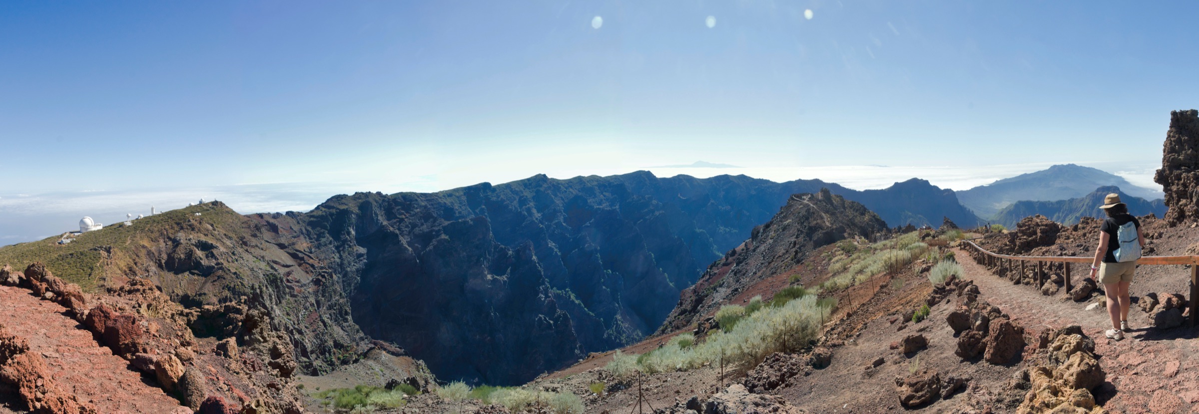
3. Roque de los Muchachos - Pico de la Nieve

Snapshot
Itinerary
The route follows the Caldera de Taburiente rim between Roque de los Muchachos and Pico de la Nieve, crossing high, open crest terrain above the caldera with observatory and island views. It returns by the same route.
Why it is essential
This is the major high-rim day hike of La Palma, linking the island’s highest accessible mountain scenery with the Caldera de Taburiente skyline.
Equipment
Mountain footwear, warm/windproof layer, sun protection, water, navigation backup, and weather-appropriate contingency planning.
Hazards and notes
The route is high, exposed, long, and vulnerable to wind, cloud, and cold. Do not rely on lowland weather as a guide to rim conditions.
GPX / KML links
| Source | URL | Format / access | Reuse status |
|---|---|---|---|
| AllTrails trail details | alltrails.com | GPX/source route page via AllTrails | AllTrails terms apply; route stats verified; GPX reuse not confirmed |
| La Palma official trail map | visitlapalma.es | Official trail-network PDF | Website/PDF terms not fully checked; route-file reuse unresolved |
| Official La Palma trail status portal | senderosdelapalma.es | Official status page | Terms not fully checked; required current-status source, not a route file |
External links
- AllTrails — Roque de los Muchachos
- La Palma official trail map
- Official La Palma trail status portal
4. PR LP 5.1 Cubo de la Galga - Somada Alta Lookout Point

Snapshot
Itinerary
The route enters Cubo de la Galga’s laurel forest and climbs to the Somada Alta viewpoint before returning by the loop route. Official material also describes shorter and longer variants, so the mapped Somada Alta loop must be kept distinct from the official 5 km short-route icon stats.
Why it is essential
Cubo de la Galga is the representative laurisilva forest hike in this La Palma set, adding humid forest and viewpoint terrain to the volcanic and ravine routes.
Equipment
Trail shoes or boots with grip, rain layer, water, and navigation backup.
Hazards and notes
Forest paths can be slippery, and landslides or fallen trees can affect PR LP 5.1 after rain or wind. Check the official footpath status page before publication or travel.
GPX / KML links
| Source | URL | Format / access | Reuse status |
|---|---|---|---|
| Visit La Palma official route page | visitlapalma.es | Official route page | Website terms not fully checked; short/long variant statistics need careful treatment |
| Visit La Palma official route PDF | visitlapalma.es | Official PDF/map sheet | Website/PDF terms not fully checked; coordinate/route reuse unresolved |
| AllTrails Somada Alta loop | alltrails.com | GPX/source route page via AllTrails | AllTrails terms apply; mapped-loop stats verified; GPX reuse not confirmed |
| Official La Palma trail status portal | senderosdelapalma.es | Official status page | Terms not fully checked; required current-status source, not a route file |
External links
- Visit La Palma — Cubo de la Galga route page
- Visit La Palma — official route PDF
- AllTrails — Cubo de la Galga / Mirador Somada Alta
- Official La Palma trail status portal
5. Nacientes Marcos y Cordero - Los Tilos


Snapshot
Itinerary
The official short route follows the water canal from Casa del Monte through the Marcos y Cordero springs area, passing the tunnel sequence and returning the same way. The full classic continuation descends toward Barranco del Agua and Los Tilos, making a much longer one-way mountain-ravine day.
Why it is essential
Marcos y Cordero is La Palma’s distinctive water-gallery hike: tunnels, springs, laurel forest, and the Los Tilos ravine system in one route.
Equipment
Torch/headlamp, waterproof layer, helmet where advised, boots with grip, water, navigation backup, and dry protection for electronics.
Hazards and notes
The official page stresses the tunnel sequence and water exposure. The full descent is not suitable for casual walkers: tunnels, wet ground, ravine terrain, landslide risk, road access, and one-way logistics all need current verification.
GPX / KML links
| Source | URL | Format / access | Reuse status |
|---|---|---|---|
| Visit La Palma official route page | visitlapalma.es | Official route page | Website terms not fully checked; official source verified; full-route distance/elevation not fully separated |
| Visit La Palma official route PDF | visitlapalma.es | Official PDF/map sheet | Website/PDF terms not fully checked; coordinate/route reuse unresolved |
| Wikiloc: Nacientes Marcos y Cordero - Los Tilos | wikiloc.com | GPX/source route page via Wikiloc | Wikiloc terms apply; secondary full-route stats/source found; GPX reuse not confirmed |
| Official La Palma trail status portal | senderosdelapalma.es | Official status page | Terms not fully checked; required current-status source, not a route file |
External links
- Visit La Palma — Nacientes Marcos y Cordero route page
- Visit La Palma — official route PDF
- Wikiloc — Nacientes Marcos y Cordero to Los Tilos
- Official La Palma trail status portal
Outstanding verification notes
- Check the official La Palma trail status portal before publication. PR-LP 13 / Caldera de Taburiente and PR LP 5.1 / Cubo de la Galga had closure or partial-closure warnings in secondary sources during this pass.
- Visit La Palma official pages sometimes provide short-route icon statistics while page text describes longer variants; this file preserves those discrepancies rather than forcing a single invented value.
- Reusable official GPX/KML files were not found in this pass; official PDFs and secondary route pages are listed for later route reconstruction.
External links
| Source | URL |
|---|---|
| Visit La Palma official hiking pages | visitlapalma.es |
| Official La Palma trail status portal | senderosdelapalma.es |
| Caldera de Taburiente National Park information | miteco.gob.es |
| Visit La Palma — Caldera de Taburiente route | visitlapalma.es |
| Visit La Palma — Ruta de los Volcanes route | visitlapalma.es |
| Visit La Palma — Cubo de la Galga route | visitlapalma.es |
| Visit La Palma — Nacientes Marcos y Cordero route | visitlapalma.es |
| AllTrails — Mirador Los Brecitos to Cascada de Colores | alltrails.com |
| AllTrails — Roque de los Muchachos | alltrails.com |
| AllTrails — Cubo de la Galga / Mirador Somada Alta | alltrails.com |
| Wikiloc — Nacientes Marcos y Cordero to Los Tilos | wikiloc.com |
| La Palma official trail map (PDF) | visitlapalma.es |