Regional overview
The Lima Andes / Cordillera Central rise abruptly east and north-east of metropolitan Lima, linking the Santa Eulalia and Rimac headwaters, Huarochiri, Canta / Cordillera La Viuda, Huaral, and the Nor Yauyos-Cochas landscape south-east of the city. The walking character is varied: dry inter-Andean valleys, high puna, rock forests, pre-Inca and Inca sites, glacier-fed lakes, waterfalls, and remote highland villages.
The main access bases are Lima, Chosica, San Pedro de Casta, Huaral / La Florida / Pampas, Chicla / Rio Blanco, Canta / Huaros, and Huancaya. Public transport exists to several towns but onward trailheads often require early starts, private vehicles, local colectivos, or organised transport.
Most routes are high enough to require acclimatisation. The dry season, roughly May to October, is generally best for views and trail conditions. Wet-season storms, river crossings, fog, and landslides can affect access roads. Several routes pass through community-managed sites or protected areas, so local access fees and rules should be expected even where official national permits are not listed.
Selection rationale
The selection represents five distinct Lima highland experiences: the Marcahuasi rock plateau, the Rupac archaeological ascent, Laguna Rapagna in the Rimac headwaters, Huallhua waterfalls in Nor Yauyos-Cochas, and Laguna Chuchun / Cordillera La Viuda above Canta. The set avoids coastal Lima walks and multi-day Huayhuash segments because the brief is specifically the Lima Andes / Cordillera Central.
Summary table
| # | Hike | Country | Route type | Distance | Gain | Max elevation | Difficulty |
|---|---|---|---|---|---|---|---|
| 1 | Marcahuasi Stone Forest from San Pedro de Casta | Peru | Loop / plateau circuit | 11.7 km | 761 m | Approx. 4,000 m | Hard |
| 2 | Rupac from Pampas / La Florida | Peru | Out-and-back | 14.6 km return from Pampas if using 7.3 km one-way source | Approx. 3,500-3,580 m | Hard | |
| 3 | Laguna Rapagna from Rio Blanco | Peru | Loop | 17.5 km | 1,356 m | Approx. 4,550 m at lake | Hard |
| 4 | Laguna Huallhua and Catarata, Huancaya | Peru | Loop | 3.9 km | 205 m | Moderate | |
| 5 | Laguna Chuchun / Cordillera La Viuda | Peru | Point-to-point / high-lake traverse candidate | 14.3 km Wikiloc variant | 1,110 m | 5,012 m Wikiloc high point | Hard |
1. Marcahuasi Stone Forest from San Pedro de Casta
Snapshot
Itinerary
From San Pedro de Casta, the route climbs to the Marcahuasi plateau, a high rock-forest landscape with named formations such as the Monumento a la Humanidad, animal-shaped rocks, lagoons, archaeological remains, and pasture. The AllTrails loop tours the plateau rather than simply reaching the entrance and returning.
The ascent is physically demanding because San Pedro de Casta is already high and the plateau is close to 4,000 m. The site has limited services; water, food, and warm clothing should be carried from the village.
Why it is essential
Marcahuasi is the classic Lima highland day or overnight hike: close enough to Lima for a long day, but with a distinctive Andean plateau, archaeological remains, and geologic rock formations that are unlike ordinary valley walks.
Equipment
- Sturdy boots
- Warm layer
- Waterproof/windproof shell
- Sun protection
- Food and water
- Map/GPS
- Headtorch
- Camping equipment only for overnight variants
Hazards and notes
- Altitude, strong sun, cold wind, storms, and navigation across the plateau are the main issues.
- Fog can make the rock maze confusing.
- Confirm community entry fees, road condition from Chosica, and whether pack animals or camping areas are operating.
GPX / KML links
| Source | URL | Format / access | Reuse status |
|---|---|---|---|
| AllTrails: Marcahuasi Stone Forest | alltrails.com | Source map; AllTrails terms apply | No direct GPX retrieved; source-map reference only |
| Wikiloc: San Pedro de Casta — Marcahuasi | wikiloc.com | Source map / GPX availability via Wikiloc | Wikiloc terms apply; GPX download not retrieved |
External links
2. Rupac from Pampas / La Florida
Snapshot
Itinerary
The usual walking approach begins from Pampas, the abandoned village above La Florida, and climbs to the fortified pre-Inca site of Rupac on the ridge. Tourism inventory material gives the Pampas-Rupac walking leg as 7.3 km / 3 hr. Some itineraries begin lower at La Florida, increasing the walking distance and height gain.
Rupac is commonly called the “Machu Picchu Limeno” or “ciudad de fuego” because of its stone buildings and sunset colour. The catalogue route is the walking access to the archaeological site, not an overnight camping itinerary.
Why it is essential
Rupac is the major cultural mountain hike north of Lima: an exposed highland ascent to one of the best-known archaeological sites in the Lima Andes.
Equipment
- Sturdy boots
- Warm layer
- Windproof/waterproof shell
- Sun protection
- Food and water (extra water for same-day return)
- Map/GPS
- Headtorch
Hazards and notes
- The route is hot and dry lower down, cold and windy higher up, and a long day if starting below Pampas.
- Road condition, community fees, and safe return transport need local confirmation.
- Do not climb on archaeological structures.
GPX / KML links
| Source | URL | Format / access | Reuse status |
|---|---|---|---|
| Wikiloc: Ruta Huaral — Rupac | wikiloc.com | Source map / GPX availability via Wikiloc | Wikiloc terms apply; GPX download not retrieved |
| Wikiloc: HUARAL — Rupak (La Florida - Pampas - Rupak) | wikiloc.com | Source map / GPX availability via Wikiloc | Wikiloc terms apply; GPX download not retrieved |
External links
- Turismo Peruano — Sitio Arqueologico de Rupak
- Peru.info — Rupac
- Wikiloc — Ruta Huaral - Rupac
- De Aventura — Rupac access notes
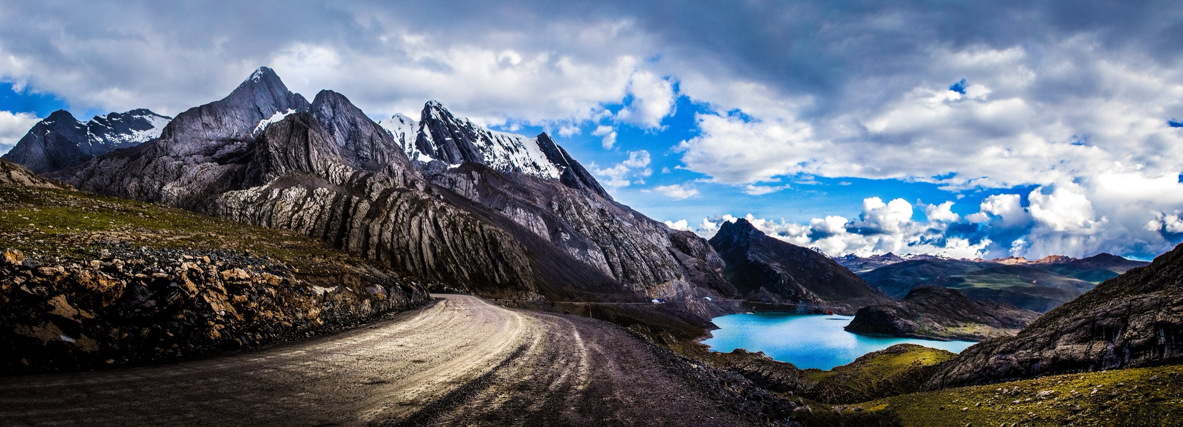
3. Laguna Rapagna from Rio Blanco
Snapshot
Itinerary
From Rio Blanco, the route climbs into the high Rimac headwater country toward Laguna Rapagna, a lake around 4,550 m. AllTrails describes a largely off-trail but accessible loop that tours the lake before returning to the start. The route has a large height gain and should be treated as a serious acclimatised high-mountain day.
Why it is essential
Laguna Rapagna is one of the most demanding and scenic lake objectives reachable from the Lima / Carretera Central corridor, representing the colder, higher Cordillera Central side of the region.
Equipment
- Mountain hiking boots
- Extra warm layer
- Gloves
- Rain shell
- Headtorch
- 2-3 litres of water
- Food
- Map/GPS and navigation backup
- Trekking poles
Hazards and notes
- The main hazards are altitude, a large climb, possible off-trail sections, storms, fog, and cold.
- This is not a casual Lima day trip; acclimatisation and an early start are important.
GPX / KML links
| Source | URL | Format / access | Reuse status |
|---|---|---|---|
| AllTrails: Laguna Rapagna | alltrails.com | Source map; AllTrails terms apply | No direct GPX retrieved; source-map reference only |
External links
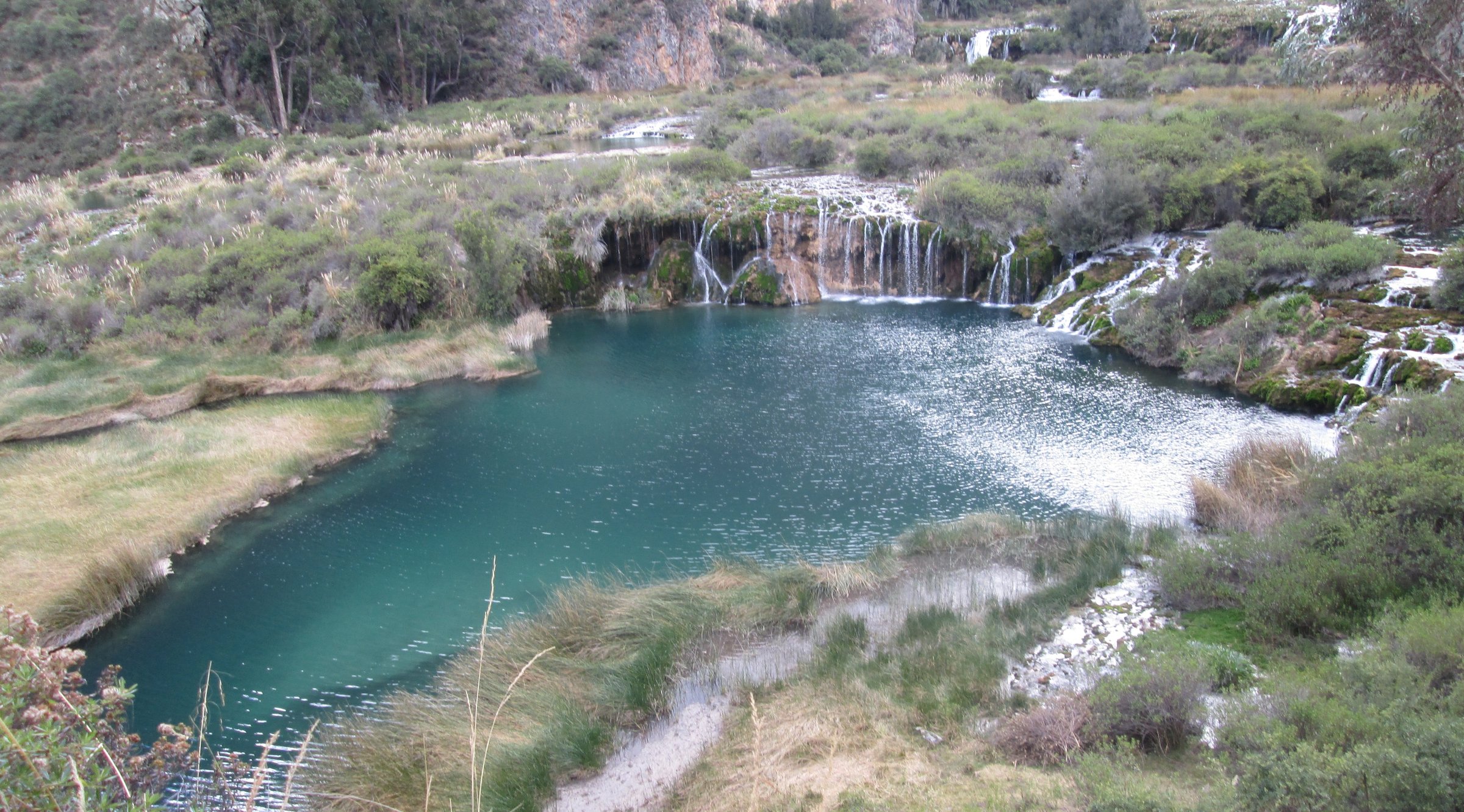
4. Laguna Huallhua and Catarata, Huancaya
Snapshot
Itinerary
The route starts at the Carhuayno viewpoint, follows the path toward the Laguna Huallhua viewpoint and waterfall, descends to the lake edge, and returns on a lakeside path. Wikiloc variants extend the walk toward Cascadas de Cabracancha and Huancaya village.
The hike lies inside Reserva Paisajistica Nor Yauyos-Cochas, Peru’s first landscape reserve, covering the upper and middle Canete basin and the Cochas-Pachacayo basin.
Why it is essential
Huancaya and Laguna Huallhua are the emblematic waterfall-and-lagoon landscape of the Lima highlands. The walk is short but strongly representative of Nor Yauyos-Cochas.
Equipment
- Hiking shoes with good grip near wet rock and waterfall spray
- Weatherproof layer
- Warm layer
- Water and snacks
- Sun protection
- Map/GPS
Hazards and notes
- Stay on established paths near waterfalls and lake edges.
- Confirm protected-area rules, local fees, and current road conditions.
- Dogs and drone rules were not verified.
GPX / KML links
| Source | URL | Format / access | Reuse status |
|---|---|---|---|
| AllTrails: Laguna Huallhua y Catarata | alltrails.com | Source map; AllTrails terms apply | No direct GPX retrieved; source-map reference only |
| Wikiloc: Laguna Huallhua — Cascadas de Cabracancha — Huancaya | wikiloc.com | Source map / GPX availability via Wikiloc | Wikiloc terms apply; GPX download not retrieved |
External links
- SERNANP — Reserva Paisajistica Nor Yauyos Cochas
- SERNANP — Nor Yauyos-Cochas tourism resources
- AllTrails — Laguna Huallhua y Catarata
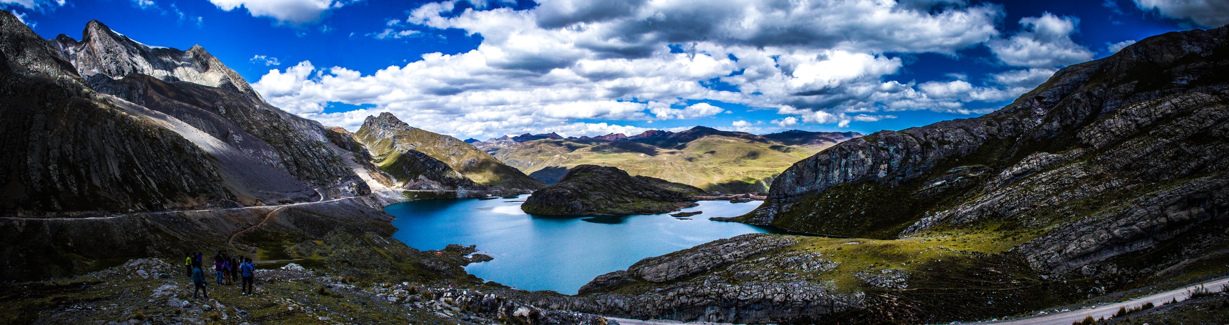
5. Laguna Chuchun / Cordillera La Viuda
Snapshot
Itinerary
Laguna Chuchun sits below Cordillera La Viuda in the Canta highlands. The selected high-level variant begins near Laguna Chuchun, continues toward Leon Cocha and viewpoints near Pachamama / La Viuda, and ends near Torococha or another road-access point depending on the exact line used. The route is a serious high-altitude traverse rather than a simple roadside photo stop.
Shorter visits to Laguna Chuchun are possible from the road; those are not equivalent to the 14.3 km high-lake traverse listed here.
Why it is essential
Cordillera La Viuda is the classic high Canta mountain landscape above Lima: puna lakes, snow-streaked peaks, and a road-accessible but harsh Cordillera Central environment.
Equipment
- Mountain hiking boots
- Extra warm layers
- Gloves
- Waterproof shell
- Headtorch
- Map/GPS and navigation backup
- Food and water
- Microspikes only if local snow or ice conditions require them
Hazards and notes
- This route exceeds 5,000 m on the Wikiloc variant and should only be attempted by acclimatised walkers in stable weather.
- Fog, snow, altitude illness, and remoteness are the main concerns.
- Confirm whether road work, reservoir works, or community access rules affect Laguna Chuchun.
GPX / KML links
| Source | URL | Format / access | Reuse status |
|---|---|---|---|
| Wikiloc: Laguna Chuchun — Leon Cocha — Pachamama — Cordillera La Viuda | wikiloc.com | Source map / GPX availability via Wikiloc | Wikiloc terms apply; GPX download not retrieved |
External links
External links
| Source | URL |
|---|---|
| AllTrails — Marcahuasi Stone Forest | alltrails.com |
| AllTrails — Laguna Rapagna | alltrails.com |
| AllTrails — Laguna Huallhua y Catarata | alltrails.com |
| SERNANP — Reserva Paisajistica Nor Yauyos Cochas | gob.pe |
| SERNANP — Nor Yauyos-Cochas tourism resources | gob.pe |
| MINCETUR inventory — Laguna Chuchun | consultasenlinea.mincetur.gob.pe |
| Peru.info — Marcahuasi | peru.info |
| Peru.info — Rupac | peru.info |
| Wikiloc — Rupac routes | wikiloc.com |
| Wikiloc — Laguna Chuchun high route | wikiloc.com |