Regional overview
The Cajamarca / Amazonas highlands are a northern Andean and Andean-Amazon transition region: cloud forest, waterfalls, deep canyons, archaeological ridges, Chachapoyas funerary sites, and Cajamarca’s high stone-and-water landscapes. The hiking character is less alpine than Huaraz: humid trails, muddy cloud-forest paths, short archaeological access walks, village-based day hikes, and culturally important routes. This region has better official tourism inventory coverage than the Cordillera Negra.
Core sources: MINCETUR tourist resource inventory, PROMPERU Amazonas practical guide PDF, Gobierno Regional Cajamarca: Cumbemayo.
Selection rationale
The selection covers the essential day-hike range of the Cajamarca and Amazonas highlands: the iconic Gocta waterfall walk, the Kuelap archaeological circuit, the Karajia sarcophagi viewpoint, the Sonche canyon rim from Huancas, and the Cumbemayo stone forest and pre-Inca aqueduct above Cajamarca.
Summary table
| # | Hike | Country | Route type | Distance | Gain | Max elevation | Difficulty |
|---|---|---|---|---|---|---|---|
| 1 | Catarata de Gocta via Cocachimba | Peru | Out-and-back | 10.3 km | 833 m | Around basin | Moderate-hard |
| 2 | Kuelap walking circuit from La Malca | Peru | Loop / site circuit | 4.7 km | 299 m | Approx. 3,000 m | Easy-moderate |
| 3 | Sarcophagi of Karajia from Cruzpata | Peru | Out-and-back | Approx. 2 km | 2,713 m | Easy-moderate | |
| 4 | Canon del Sonche from Huancas | Peru | Loop | 5.5 km | 250 m | 2,620 m at resource | Moderate |
| 5 | Cumbemayo stone forest and aqueduct circuit | Peru | Short loop; longer variants | 2.9 km loop; 7.6 km variant | 110 m loop; 209 m variant | 3,500 m; 3,606 m on loop | Easy-moderate |
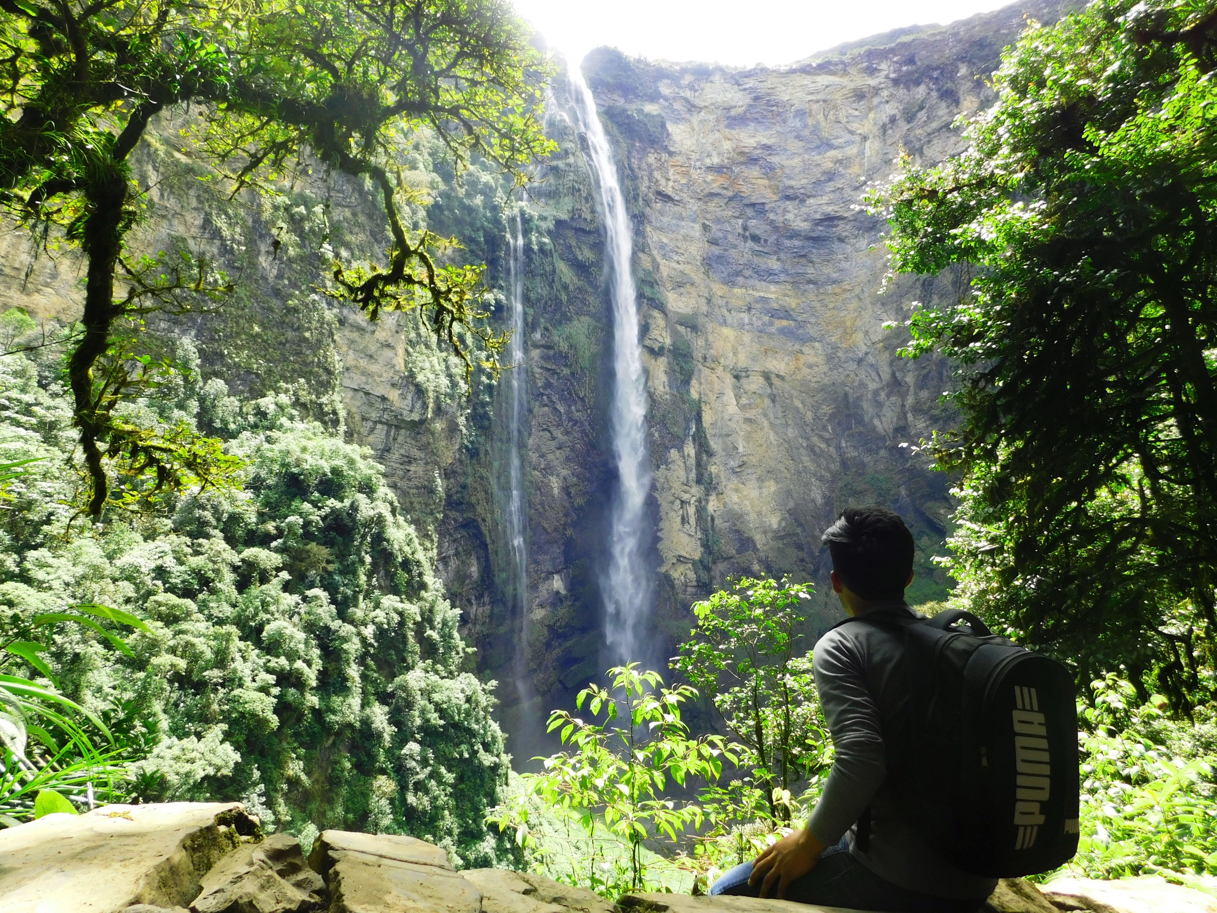
1. Catarata de Gocta via Cocachimba
Snapshot
Itinerary
Follow the signed/community trail from Cocachimba through humid forest and viewpoints to the base of the lower drop of Gocta waterfall, then return the same way.
Why it is essential
Gocta is the region’s signature natural hike and one of Peru’s iconic waterfalls.
Equipment
- Waterproof shoes or boots
- Rain shell/poncho
- Water
- Insect protection
- Trekking poles in mud
Hazards and notes
- Mud and slippery steps.
- Mist and falling water near the base.
- Heat/humidity.
- Horses on trail.
GPX / KML links
| Source | URL | Format / access | Reuse status |
|---|---|---|---|
| AllTrails: Catarata Gocta via Cocachimba | alltrails.com | Source map / route statistics; AllTrails terms apply | GPX reuse unresolved |
| Gocta Andes Lodge activities | goctalodge.com | Local/community trail description; no GPX | Context only |
| MINCETUR inventory, Gocta resource | mincetur.gob.pe | Official resource inventory; no GPX | Context only |
External links
- AllTrails — Catarata Gocta via Cocachimba
- Gocta Andes Lodge — Activities
- MINCETUR — Gocta resource inventory
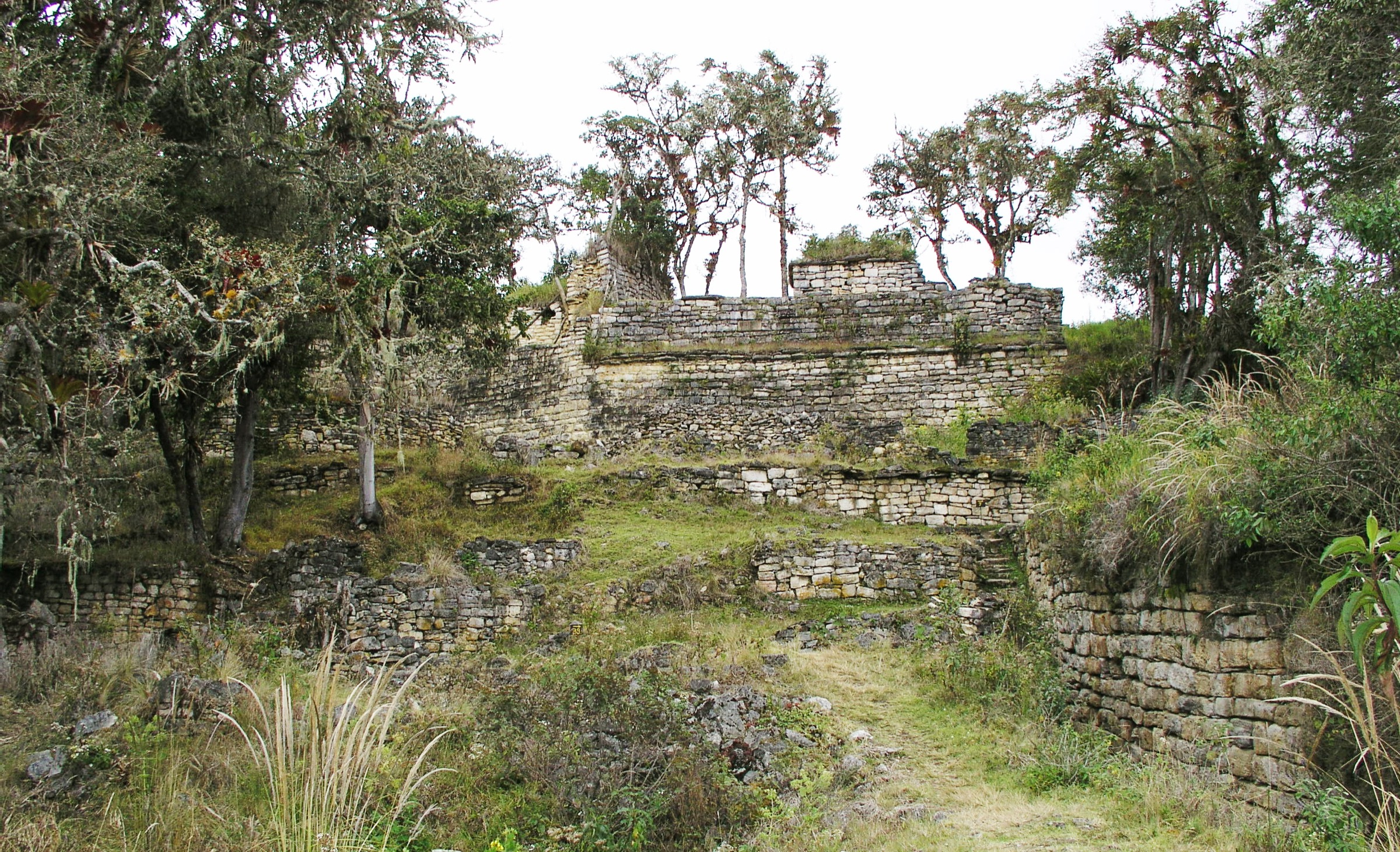
2. Kuelap walking circuit from La Malca
Snapshot
Itinerary
From the cable-car arrival area, walk to and through the authorized Kuelap visitor circuits, viewing the walled Chachapoyas complex and surrounding mountain ridges.
Why it is essential
Kuelap is the major archaeological landmark of the north Peruvian Andes, and the site approach/circuit is the key cultural walk in the Amazonas highlands.
Equipment
- Comfortable walking shoes
- Rain shell
- Sun protection
- Water
Hazards and notes
- Archaeological-site restrictions.
- Wet steps.
- Cliffs/walls.
- Possible closures or reroutes.
GPX / KML links
| Source | URL | Format / access | Reuse status |
|---|---|---|---|
| AllTrails: Ruta Kuelap | alltrails.com | Source map / route statistics; AllTrails terms apply | GPX reuse unresolved |
| Official Kuelap Ministry of Culture site | kuelap.cultura.pe | Official current-access source; no GPX | Context only |
| Telecabinas Kuelap services | telecabinaskuelap.com | Official cable-car access information; no GPX | Context only |
External links
- AllTrails — Ruta Kuelap
- Ministry of Culture — Official Kuelap site
- Telecabinas Kuelap — Services
- Ministry of Culture — May 2025 circuits notice
- Ministry of Culture — February 2026 emergency declaration
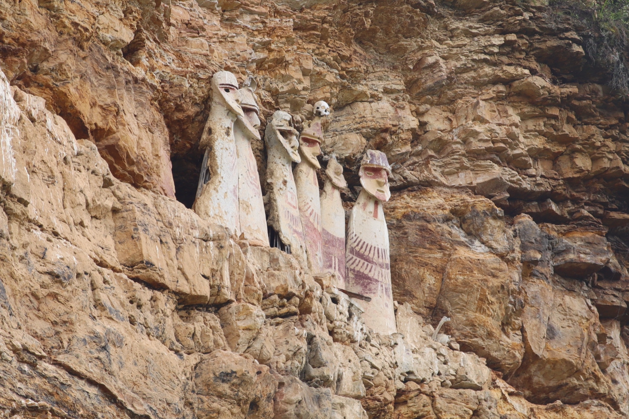
3. Sarcophagi of Karajia from Cruzpata
Snapshot
Itinerary
Walk from Cruzpata down/up local trail to the viewpoint facing the cliff-mounted Chachapoyas sarcophagi of Karajia.
Why it is essential
It is the most iconic Chachapoyas funerary-site walk in the region.
Equipment
- Walking shoes
- Rain/sun protection
- Water
Hazards and notes
- Steep trail.
- Cliff-viewing area.
- Site protection rules; do not leave the visitor route.
GPX / KML links
| Source | URL | Format / access | Reuse status |
|---|---|---|---|
| AllTrails: Sarcofago de Karajia | alltrails.com | Source map; AllTrails terms apply | GPX reuse unresolved |
| MINCETUR inventory: Sitio Arqueologico Karajia | mincetur.gob.pe | Official resource inventory; no GPX | Context only |
| Gocta Lodge Karajia activity description | goctalodge.com | Local walking distance/time source; no GPX | Context only |
External links
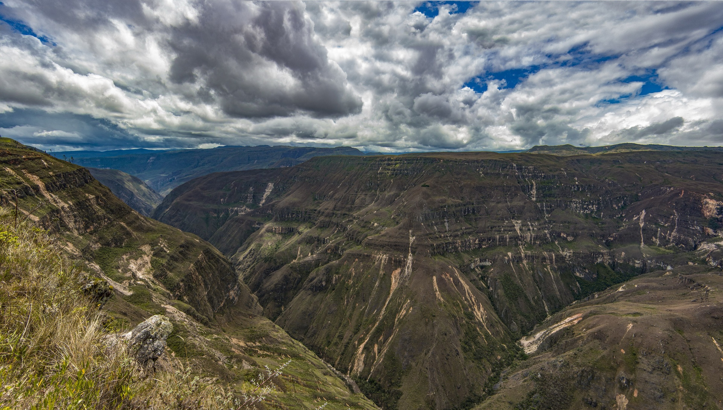
4. Canon del Sonche from Huancas
Snapshot
Itinerary
Walk along the Huancas rim route to viewpoints over Canon del Sonche, with views into the deep canyon and surrounding Andean-Amazon landscape.
Why it is essential
It is the most accessible canyon-rim hike from Chachapoyas and a strong landscape counterpoint to the archaeology and waterfalls.
Equipment
- Walking shoes
- Sun/rain protection
- Water
Hazards and notes
- Sheer canyon edges; keep distance from unprotected rim sections.
GPX / KML links
| Source | URL | Format / access | Reuse status |
|---|---|---|---|
| AllTrails: Canon del Sonche | alltrails.com | Source map / route statistics; AllTrails terms apply | GPX reuse unresolved |
| MINCETUR inventory: Canon del Sonche | mincetur.gob.pe | Official resource inventory; no GPX | Context only |
External links
5. Cumbemayo stone forest and aqueduct circuit
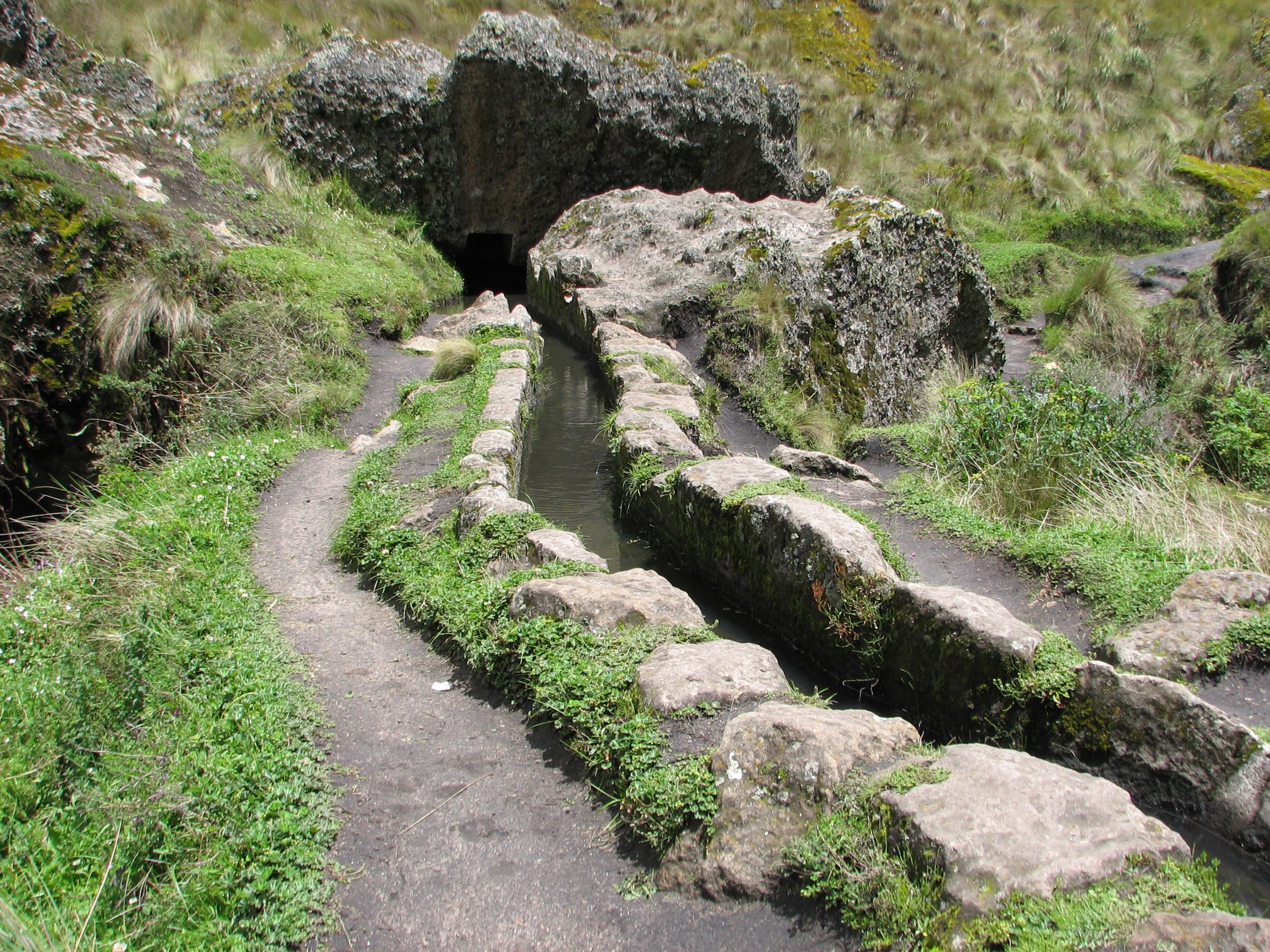
Snapshot
Itinerary
Walk through the Cumbemayo stone forest, narrow rock passages, carved aqueduct, petroglyph/ceremonial areas, and high Cajamarca puna landscape.
Why it is essential
It is Cajamarca’s defining highland walk, combining geology, pre-Inca hydraulic engineering, and accessible puna scenery.
Equipment
- Walking shoes
- Wind/rain layer
- Sun protection
- Water
Hazards and notes
- Narrow rock passages.
- Slippery stone.
- Altitude.
- Fragile archaeological features.
GPX / KML links
| Source | URL | Format / access | Reuse status |
|---|---|---|---|
| Wikiloc: Bosque de piedra de Cumbemayo | wikiloc.com | Source route; Wikiloc terms apply | GPX reuse unresolved |
| AllTrails: Cumbe Mayo on foot | alltrails.com | Longer walking variant; AllTrails terms apply | GPX reuse unresolved |
| MINCETUR inventory: Complejo Arqueologico Cumbemayo | mincetur.gob.pe | Official resource inventory; no GPX | Context only |
| Gobierno Regional Cajamarca: Cumbemayo | regioncajamarca.gob.pe | Official regional tourism source; no GPX | Context only |
External links
- Wikiloc — Bosque de piedra de Cumbemayo
- AllTrails — Cumbe Mayo on foot
- MINCETUR — Cumbemayo inventory
- Gobierno Regional Cajamarca — Cumbemayo
External links
| Source | URL |
|---|---|
| MINCETUR — Tourist resource inventory | mincetur.gob.pe |
| PROMPERU — Amazonas practical guide (PDF) | promperu.gob.pe |
| Gobierno Regional Cajamarca — Cumbemayo | regioncajamarca.gob.pe |
| AllTrails — Catarata Gocta via Cocachimba | alltrails.com |
| AllTrails — Ruta Kuelap | alltrails.com |
| AllTrails — Sarcofago de Karajia | alltrails.com |
| AllTrails — Canon del Sonche | alltrails.com |
| AllTrails — Cumbe Mayo on foot | alltrails.com |
| Wikiloc — Bosque de piedra de Cumbemayo | wikiloc.com |
| Gocta Andes Lodge — Activities | goctalodge.com |
| Gocta Lodge — Activities (Spanish) | goctalodge.com |
| Ministry of Culture — Official Kuelap site | kuelap.cultura.pe |
| Telecabinas Kuelap — Services | telecabinaskuelap.com |
| Ministry of Culture — May 2025 Kuelap circuits notice | gob.pe |
| Ministry of Culture — February 2026 Kuelap emergency declaration | gob.pe |
| MINCETUR — Gocta resource inventory | mincetur.gob.pe |
| MINCETUR — Karajia inventory | mincetur.gob.pe |
| MINCETUR — Canon del Sonche inventory | mincetur.gob.pe |
| MINCETUR — Cumbemayo inventory | mincetur.gob.pe |