Regional overview
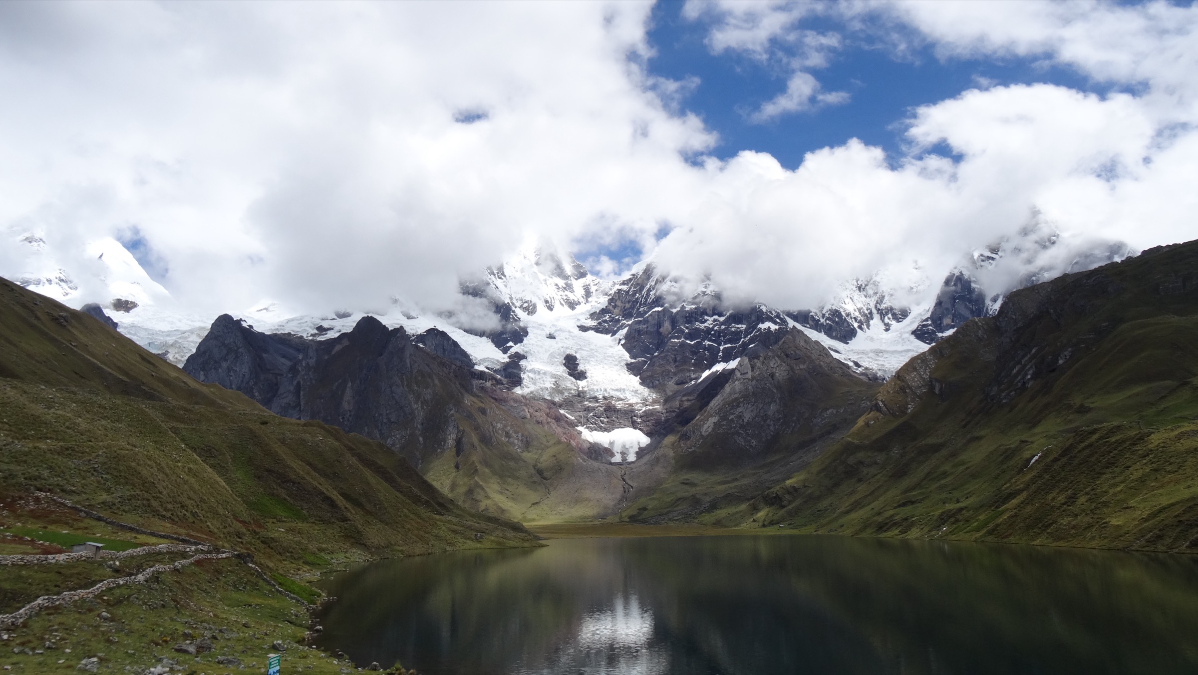
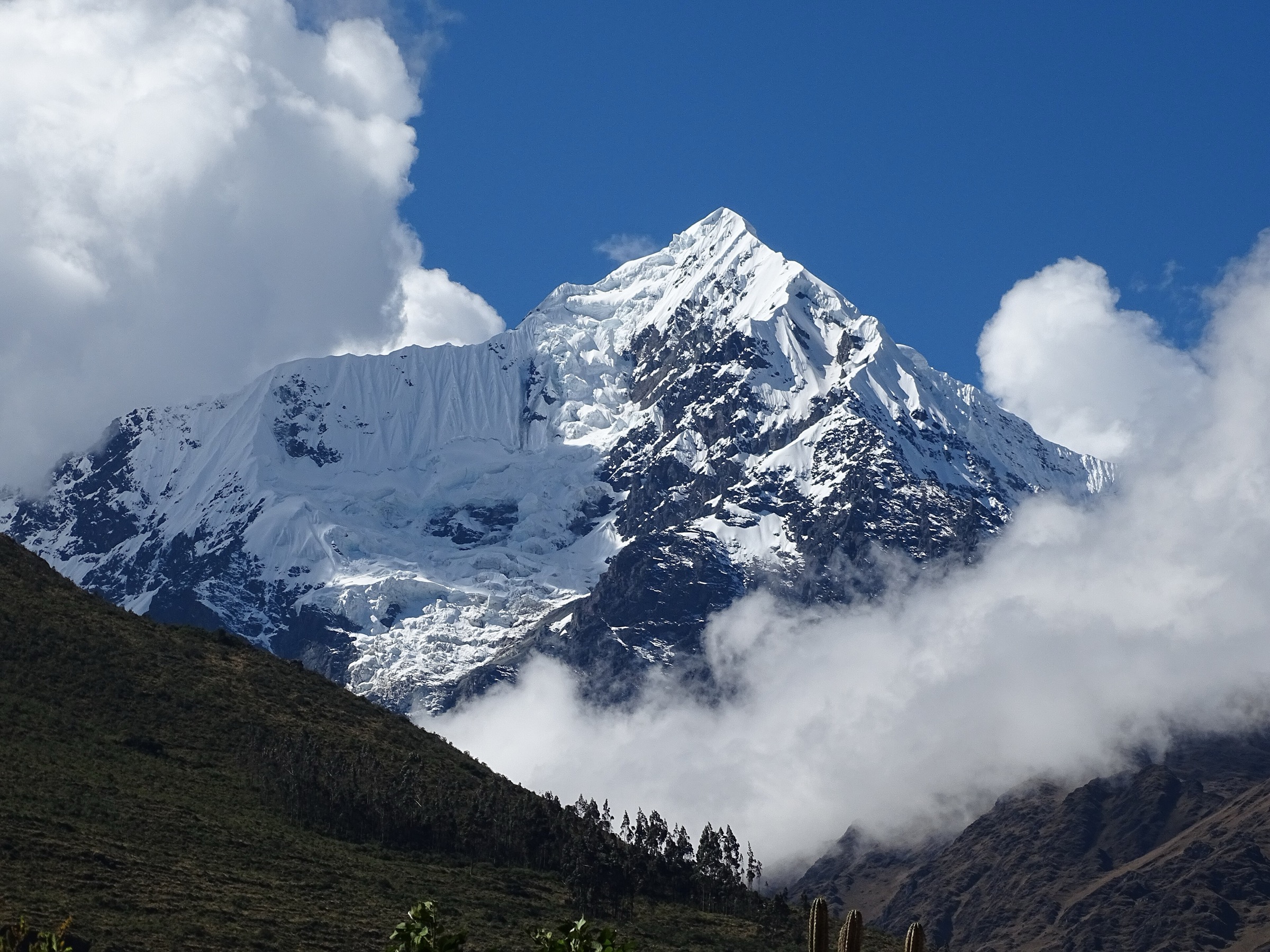
The Cordillera Blanca is the highest tropical mountain range in the world and the core of Parque Nacional Huascarán, with 6,000 m peaks, glaciers, turquoise lakes, queñual woodland, high valleys and long-established trekking centres around Huaraz, Caraz, Yungay and Carhuaz. The region’s famous multi-day treks are outside this day-hike catalogue, but several of its defining places can be reached on strenuous day walks.
Most routes start between 3,800 m and 4,500 m, so acclimatisation is not optional. SERNANP lists May-October as the recommended season, with a predominantly dry and cold climate; October-April is the rainy season. The official park visitor page also states that use of authorised tourism operators is mandatory for visits to the ANP, and current route access should be checked before departure.
The main hazards are altitude sickness, cold, storms, intense sun, rock steps, glacial-lake terrain, early starts, long transfers and changing park rules. Dogs are not appropriate in the protected area; follow SERNANP control-post instructions and stay on signed routes.
Selection rationale
The selection covers the Cordillera Blanca’s five essential day-hike experiences: Laguna 69, Laguna Churup, Laguna Parón, Pastoruri’s climate-change route and Laguna Llaca. The Santa Cruz trek and mountaineering objectives such as Pisco, Vallunaraju and Alpamayo are excluded because they require multi-day trekking or technical climbing.
Summary table
| # | Hike | Country | Route type | Distance | Gain | Max elevation | Difficulty |
|---|---|---|---|---|---|---|---|
| 1 | Laguna 69 from Cebollapampa | Peru | Out-and-back | 13.7 km | 830 m | 4,604-4,610 m | Hard |
| 2 | Laguna Churup from Pitec | Peru | Out-and-back | 6.3 km | 656 m | approx. 4,450 m | Hard |
| 3 | Laguna Parón Overlook Trail | Peru | Out-and-back | 1.8 km viewpoint route; longer lake walks possible | 134 m | approx. 4,200 m | Moderate |
| 4 | Pastoruri / Ruta del Cambio Climático | Peru | Out-and-back | 3.9 km | 207 m | approx. 5,000 m | Moderate by terrain, hard by altitude |
| 5 | Quebrada and Laguna Llaca | Peru | Out-and-back | 8.0 km | 292 m | approx. 4,474 m | Hard by altitude |
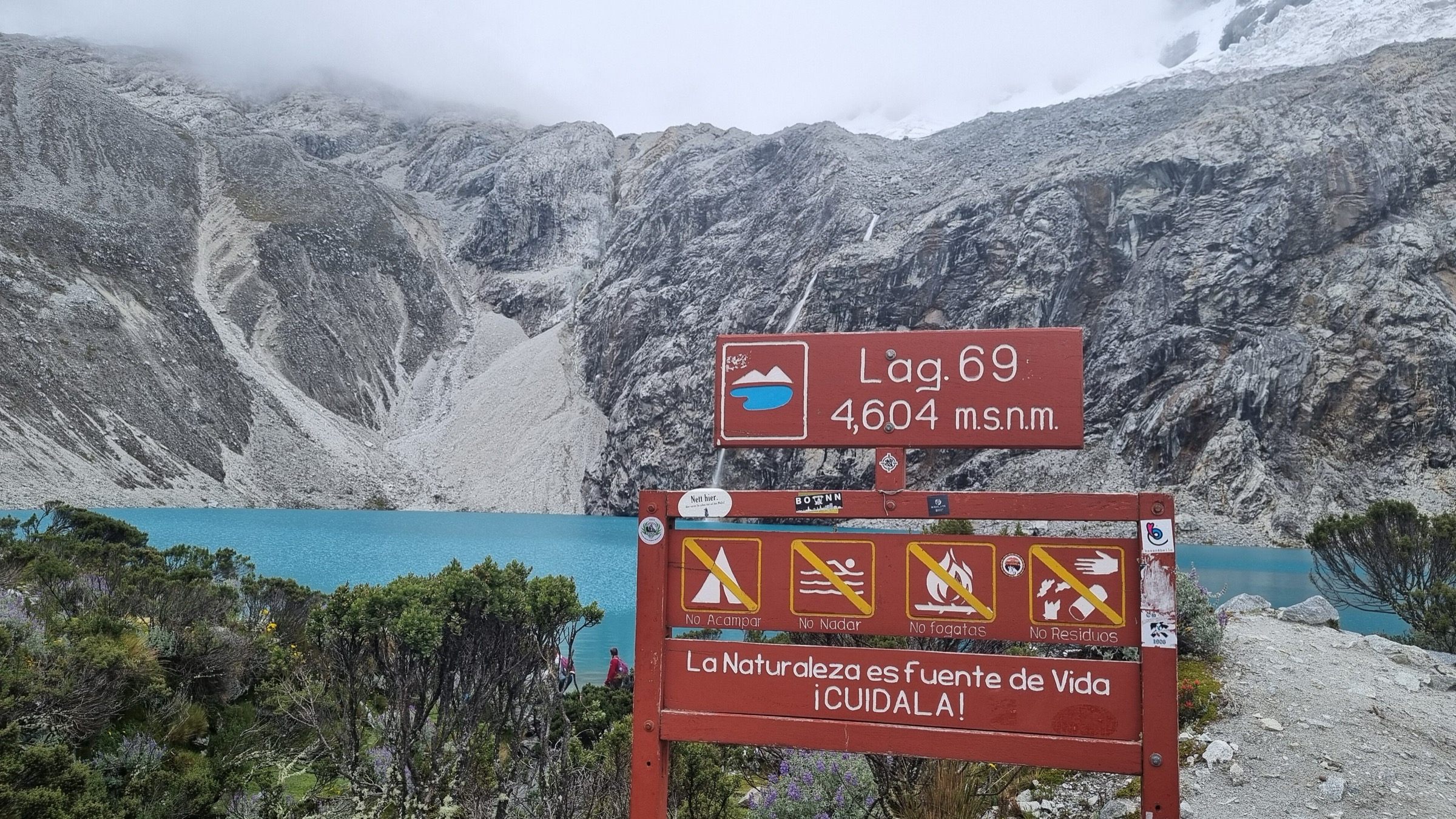
1. Laguna 69 from Cebollapampa
Snapshot
Itinerary
The route enters the Llanganuco sector, passing Chinancocha, Orconcocha and the Yuraccorral / Cebollapampa trailhead before climbing into the Quebrada Demanda basin. The path follows valley meadows, streams and waterfalls, then climbs more steeply to Laguna 69 below Chacraraju and near Pisco.
SERNANP lists Laguna 69 as a one-day trekking route in the Llanganuco sector. AllTrails records 13.7 km out-and-back with 830 m of ascent; Andeshandbook lists the lake at about 4,610 m and describes the 3-4 hour ascent from Cebollapampa.
Why it is essential
Laguna 69 is the Cordillera Blanca’s iconic day hike: a concentrated route to a turquoise glacial lake directly below major 6,000 m peaks.
Equipment
- Sturdy boots
- Warm layer
- Waterproof shell
- Hat and gloves
- Sun protection
- 2 litres of water
- Food
- Headtorch
- Map/GPS
- Trekking poles
- Emergency layers for cold rain or delays
Hazards and notes
- Altitude sickness is common if not acclimatised.
- The route is busy in high season, but weather, cold and slow ascent can still make it serious.
- SERNANP requires authorised operators for park visits; confirm current entry rules, ticketing and route status.
GPX / KML links
| Source | URL | Format / access | Reuse status |
|---|---|---|---|
| AllTrails: Laguna 69 Trail | alltrails.com | Source map / downloadable route via account; AllTrails terms apply | Source-map reference only; direct GPX not retrieved |
| Andeshandbook: Laguna 69 | andeshandbook.org | Guide route page; site terms apply | Route reference only |
| OpenStreetMap search: Laguna 69 | openstreetmap.org | Map geometry cross-check; OSM data is ODbL | Geometry cross-check only |
External links
- SERNANP — Parque Nacional Huascarán visitor page
- AllTrails — Laguna 69 Trail
- Andeshandbook — Laguna 69
2. Laguna Churup from Pitec
Snapshot
Itinerary
From Pitec, the trail climbs steeply above Huaraz toward the rocky valley below Nevado Churup. The route passes viewpoints back toward Huaraz and the surrounding peaks, then enters a steeper rock-and-waterfall section. SERNANP describes Laguna Churup as a one-day route with a control post, rests, route signage and equipment for rocky zones.
AllTrails records 6.3 km out-and-back with 656 m of ascent. The upper rock step commonly uses fixed aids or chains; wet conditions make this section more serious.
Why it is essential
Churup is the classic Huaraz acclimatisation hike and a more rugged alternative to Laguna 69: shorter, steeper and closer to the city, with a high lake below Nevado Churup.
Equipment
- Boots with good grip
- Waterproof layer
- Warm layer
- Sun protection
- Water and snacks
- Gloves for fixed aids/rock
- Map/GPS
- Trekking poles for the lower trail
Hazards and notes
- The fixed-aid/rock section is exposed enough to turn back in rain, ice or poor confidence.
- Altitude remains a serious issue.
- Confirm SERNANP entry, operator requirements and current trail condition.
GPX / KML links
| Source | URL | Format / access | Reuse status |
|---|---|---|---|
| AllTrails: Churup Lagoon | alltrails.com | Source map / downloadable route via account; AllTrails terms apply | Source-map reference only |
| OpenStreetMap search: Laguna Churup | openstreetmap.org | Map geometry cross-check; OSM data is ODbL | Geometry cross-check only |
External links
3. Laguna Parón Overlook Trail
Snapshot
Itinerary
The day outing reaches Laguna Parón by road from Caraz, then follows the short rocky trail to the classic overlook above the turquoise lake. SERNANP identifies Laguna Parón as the largest lake in Huascarán National Park, formed by deglaciation of surrounding peaks including Caraz, Artesonraju, Huandoy, Paria, Pirámide, Chacraraju and Pisco.
AllTrails records the overlook trail as 1.8 km out-and-back with 134 m of ascent. A longer lake-edge route toward Artesoncocha is a separate, more committing variant.
Why it is essential
Parón is the essential low-effort, high-impact lake viewpoint of the Cordillera Blanca: the range’s largest famous turquoise lake with a skyline of major peaks.
Equipment
- Sturdy shoes
- Warm/waterproof layer
- Sun protection
- Water
- Full mountain day kit and navigation for longer lake-edge variants
Hazards and notes
- The walk is short but still at high altitude.
- Road access, community arrangements and park restrictions can change.
- Do not assume boating/kayak services or road opening without current confirmation.
GPX / KML links
| Source | URL | Format / access | Reuse status |
|---|---|---|---|
| AllTrails: Laguna Paron Overlook Trail | alltrails.com | Source map / downloadable route via account; AllTrails terms apply | Source-map reference only |
| AllTrails: Laguna Parón - Laguna Artesoncocha | alltrails.com | Source map for longer variant; AllTrails terms apply | Variant reference only |
External links
4. Pastoruri / Ruta del Cambio Climático
Snapshot
Itinerary
The Ruta del Cambio Climático approaches the Pastoruri glacier viewpoint from the Sector Carpa visitor route. SERNANP describes the route as a one-day visit where walkers can see the impacts of glacier retreat, new lakes, fossils, Laguna Patococha, the climate-change interpretation centre, Aguas Gasificadas and Pumapashimin. AllTrails records the walking section as 3.9 km out-and-back with 207 m of ascent.
Why it is essential
Pastoruri is the Cordillera Blanca’s signature climate-change interpretation walk: less wild than the lake treks, but central to understanding tropical glacier retreat in Huascarán.
Equipment
- Sturdy shoes
- Waterproof/windproof layer
- Warm layer
- Hat and gloves
- Sun protection
- Water and snacks
- Horses for part of the approach where locally available
Hazards and notes
- The route reaches about 5,000 m, so altitude can be severe despite the short path.
- SERNANP issued past weather-related time restrictions for Pastoruri; current opening, operator requirements and weather should be checked before travel.
- Do not walk onto glacier ice.
GPX / KML links
| Source | URL | Format / access | Reuse status |
|---|---|---|---|
| AllTrails: Mirador Pastoruri | alltrails.com | Source map / downloadable route via account; AllTrails terms apply | Source-map reference only |
| SERNANP Huascarán visitor page: Ruta del Cambio Climático | sernanp.gob.pe | Official route description | Official context only; no GPX |
External links
- SERNANP — Parque Nacional Huascarán visitor page (Ruta del Cambio Climático)
- MINAM/SERNANP 2016 Pastoruri weather-related measures
- AllTrails — Mirador Pastoruri
5. Quebrada and Laguna Llaca
Snapshot
Itinerary
The Llaca valley walk follows a high glacial valley west of Huaraz toward Laguna Llaca, with views toward the Ocshapalca / Ranrapalca / Vallunaraju area. AllTrails records the Quebrada and Laguna Llaca source route as 8.0 km out-and-back with 292 m of ascent. SERNANP’s Huascarán visitor page lists the Huaraz-to-Llaca access distance, confirming Llaca as an official park access destination, though the page does not provide a detailed route panel for this hike.
Why it is essential
Llaca gives a quieter, road-accessible glacial valley walk close to Huaraz and balances the crowded Laguna 69 / Churup objectives with a classic Cordillera Blanca quebrada experience.
Equipment
- Boots
- Waterproof/windproof layer
- Warm layer
- Sun protection
- Water and food
- Map/GPS
- Headtorch
- Trekking poles for rough valley ground
Hazards and notes
- Road access and exact start point affect distance.
- The valley is high, cold and exposed to weather.
- Confirm current operator/entry rules, road condition and safe turnaround locally.
GPX / KML links
| Source | URL | Format / access | Reuse status |
|---|---|---|---|
| AllTrails: Quebrada and Laguna Llaca | alltrails.com | Source map / downloadable route via account; AllTrails terms apply | Source-map reference only |
| OpenStreetMap search: Laguna Llaca | openstreetmap.org | Map geometry cross-check; OSM data is ODbL | Geometry cross-check only |
External links
- SERNANP — Parque Nacional Huascarán visitor page (Llaca access distance)
- AllTrails — Quebrada and Laguna Llaca
External links
| Source | URL |
|---|---|
| SERNANP — Parque Nacional Huascarán visitor page | sernanp.gob.pe |
| MINAM/SERNANP — Pastoruri weather-related measures | gob.pe |
| Andeshandbook — Laguna 69 | andeshandbook.org |
| AllTrails — Laguna 69 Trail | alltrails.com |
| AllTrails — Churup Lagoon | alltrails.com |
| AllTrails — Laguna Paron Overlook Trail | alltrails.com |
| AllTrails — Laguna Parón - Laguna Artesoncocha | alltrails.com |
| AllTrails — Mirador Pastoruri | alltrails.com |
| AllTrails — Quebrada and Laguna Llaca | alltrails.com |