Regional overview
The Cordillera Volcánica around Arequipa is a high, dry volcanic landscape of ash slopes, lava ridges, puna wetlands, salt lakes, stone forests and major cones including Misti, Chachani, Pichu Pichu, Ampato and Sabancaya. The region’s day-hiking character is dominated by altitude rather than forested trail mileage: many routes start above 4,300 m, and the highest objectives approach or exceed 5,000 m.
Arequipa, Chiguata, Yura, Pampa Cañahuas, Imata and the Salinas y Aguada Blanca National Reserve are the practical access zones. Several volcano “hikes” are normally done with 4WD access, early starts, guides and acclimatisation. Misti and Chachani are included only in their commonly walked non-technical forms; Ampato is not selected as a normal catalogue day hike because a suitable non-technical, verified day route was not found in this pass and the mountain is more expedition-like.
The dry season is generally best, but wind, cold, snow patches, altitude illness, volcanic ash, loose scree and remote vehicle access can make even short routes serious. Current reserve access, volcanic alerts and local guide requirements should be checked before departure.
Selection rationale
The set balances two iconic Arequipa volcano objectives, one high Pichu Pichu ridge/summit route, one flat Salinas high-wetland walk and one lower-commitment waterfall/stone-country walk at Pillones. It represents the region better than choosing five summit cones, and it avoids presenting Ampato as a routine day hike without adequate verification.
Summary table
| # | Hike | Country | Route type | Distance | Gain | Max elevation | Difficulty |
|---|---|---|---|---|---|---|---|
| 1 | Chachani Volcano from the high camp roadhead | Peru | Out-and-back | 11.6 km | 1,118 m | 6,036 m | Hard high-altitude hike |
| 2 | Misti Volcano - Chiguata Route to high camp | Peru | Point-to-point day section | 4.3 km | 1,200 m | 4,697 m | Hard |
| 3 | Pichu Pichu / Simbral high route | Peru | Loop | 7.34 km | 945 m | 5,289 m | Hard |
| 4 | Laguna de Salinas shore and wetland circuit | Peru | Loop | 6.71 km | 1 m | 4,320 m | Easy by terrain, moderate by altitude |
| 5 | Pillones Pauza Waterfall | Peru | Out-and-back | 3.4 km | 70 m | 4,429 m | Easy-moderate by terrain/altitude |
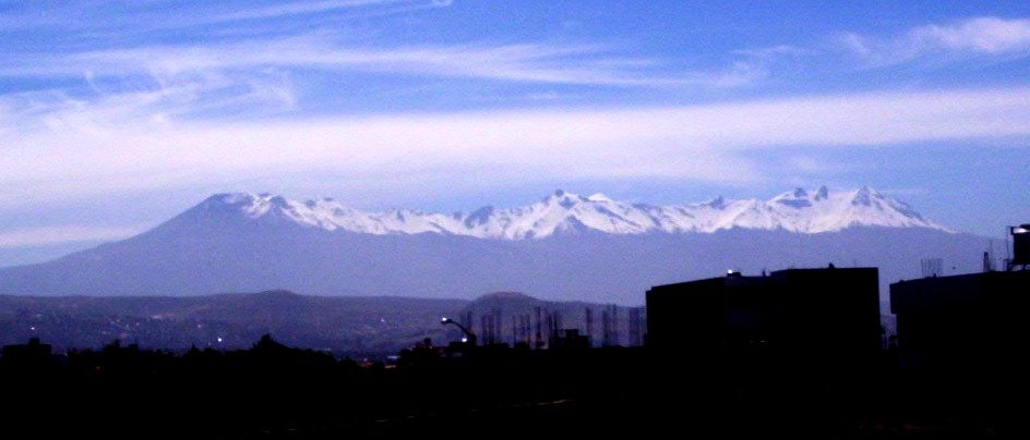
1. Chachani Volcano from the high camp roadhead
Snapshot
Itinerary
The AllTrails Chachani route represents the high summit stage from the road/camp access area toward the summit massif. The line climbs loose volcanic slopes and high ridges to one of the most accessible 6,000 m summits near Arequipa. It is often described as non-technical in dry conditions, but the altitude, cold and exposure make it a serious mountain day.
Why it is essential
Chachani is the signature high volcano above Arequipa and one of the world’s most accessible 6,000 m walking summits when conditions, acclimatisation and logistics align.
Equipment
- Mountaineering boots or stiff hiking boots
- Warm layers
- Insulated gloves and hat
- Windproof/waterproof shell
- Sunglasses and sunscreen
- Headtorch
- Water and food
- GPS/offline map
- Trekking poles
- Microspikes or crampons may be required after snow or firm ice; local guide advice is essential
Hazards and notes
- Acute mountain sickness, hypothermia, strong wind, snow/ice, loose scree and remote access are the core hazards.
- A guide is strongly recommended.
- Do not treat the route as a normal lowland day hike.
GPX / KML links
| Source | URL | Format / access | Reuse status |
|---|---|---|---|
| AllTrails: Chachani Volcano | alltrails.com | Source map / route platform; AllTrails terms apply | Source-map reference only; direct GPX reuse unresolved |
External links
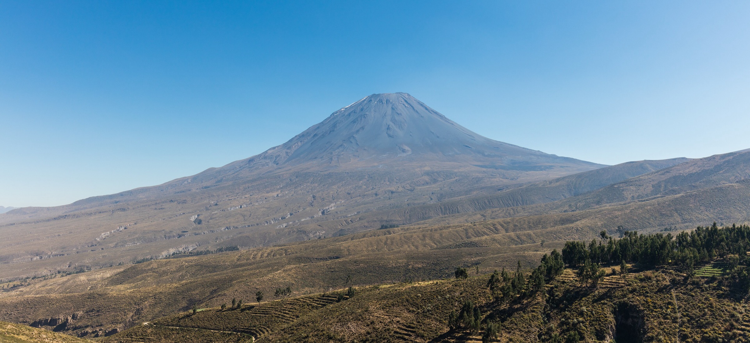
2. Misti Volcano - Chiguata Route to high camp
Snapshot
Itinerary
This route is the Chiguata-side approach toward Misti high camp rather than the complete summit ascent. The path climbs very steep volcanic terrain from the south side, gaining about 1,200 m in only 4.3 km to reach the camp area near 4,700 m. The full Misti summit is normally a two-day guided climb, so this catalogue entry treats the first-day approach as the feasible day section.
Why it is essential
Misti is Arequipa’s defining volcano. The Chiguata approach gives a non-technical but strenuous way to experience the mountain’s lower high-altitude slopes without presenting the summit as a casual day hike.
Equipment
- Boots
- Windproof/waterproof shell
- Warm layer
- Gloves and hat
- Sunglasses and sunscreen
- Water and food
- Headtorch
- Offline map/GPS
- Trekking poles
- A guide is recommended for route choice and current conditions
Hazards and notes
- The line is steep, exposed and high.
- Altitude illness, loose volcanic ash/scree, cold wind and poor visibility are the main hazards.
- Check current volcanic alerts and do not continue toward the summit without appropriate logistics and acclimatisation.
GPX / KML links
| Source | URL | Format / access | Reuse status |
|---|---|---|---|
| AllTrails: Misti Volcano - Chiguata Route | alltrails.com | Source map / route platform; AllTrails terms apply | Source-map reference only; direct GPX reuse unresolved |
External links
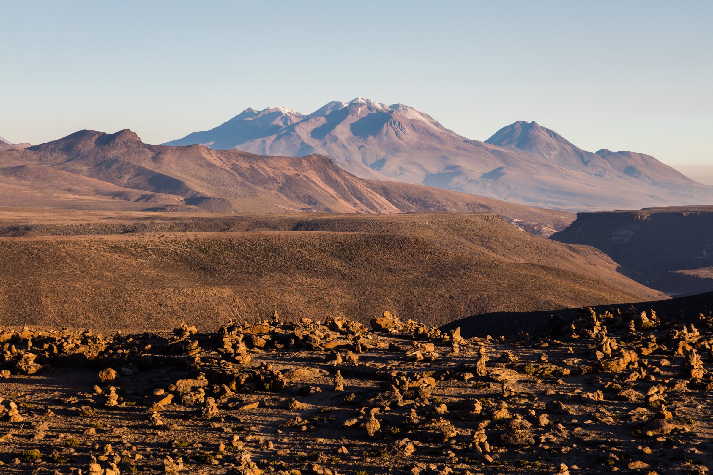
3. Pichu Pichu / Simbral high route
Snapshot
Itinerary
The Wikiloc route climbs from the Chiguata-Salinas road area toward the Simbral summit of the Pichu Pichu volcanic complex. The source description notes no visible trail in places, a north-south line toward the summit ridge, and more than 900 m of ascent in a short distance. Views include Misti, Chachani, Ubinas and Laguna de Salinas.
Why it is essential
Pichu Pichu is the third great volcano of the Arequipa skyline. The Simbral route adds a less tourist-standard, culturally significant high ridge to the more famous Misti and Chachani objectives.
Equipment
- Boots
- Warm layers
- Windproof shell
- Gloves and hat
- Sunglasses and sunscreen
- Water and food
- Headtorch
- GPS/offline map
- Trekking poles
- Navigation backup is important because the source notes limited trail definition
Hazards and notes
- Altitude, cold, wind, loose volcanic slopes, no clear path in places and remote road access make this a serious day.
- A local guide or party with high-altitude navigation experience is recommended.
GPX / KML links
| Source | URL | Format / access | Reuse status |
|---|---|---|---|
| Wikiloc: Peru. Arequipa. Pichu Pichu Simbral | wikiloc.com | Source route / GPX platform; Wikiloc terms apply | Source-map reference; direct GPX reuse unresolved |
External links
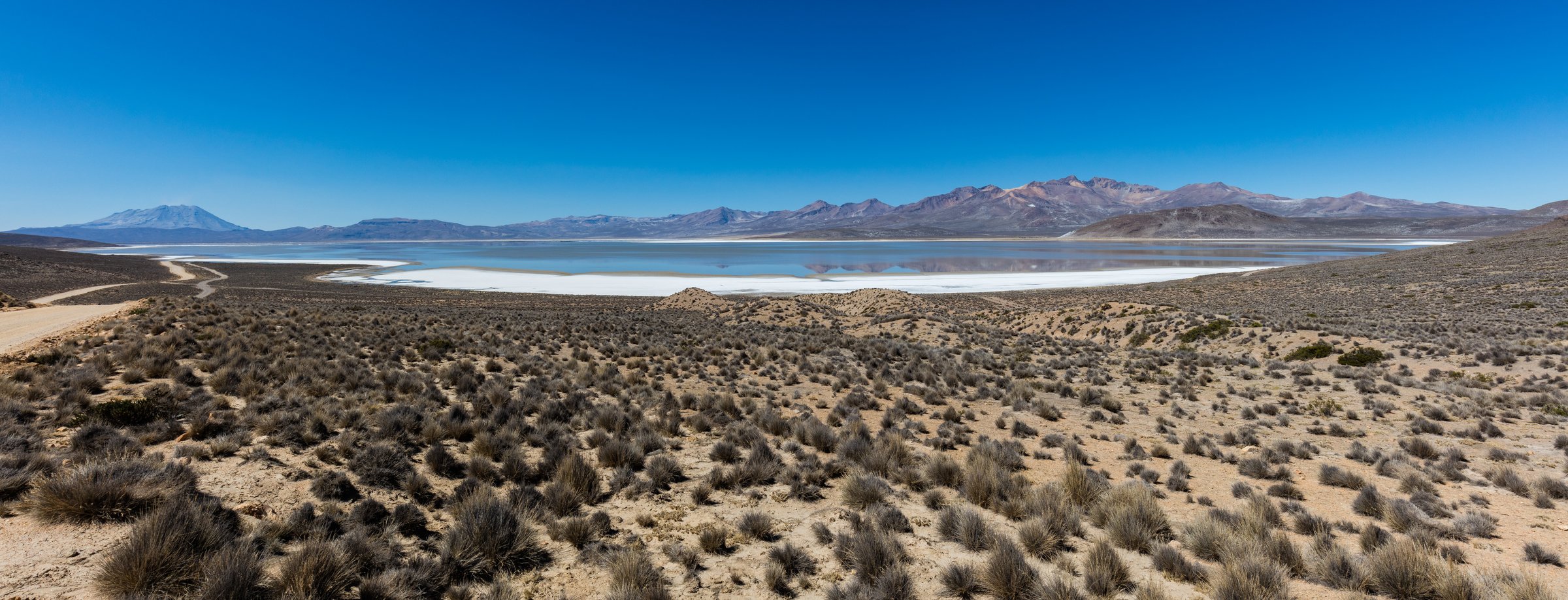
4. Laguna de Salinas shore and wetland circuit
Snapshot
Itinerary
The route follows open pastoral and wetland tracks around part of Laguna de Salinas, a high endorheic salt lake and Ramsar wetland within the Salinas y Aguada Blanca National Reserve. The walking is nearly flat, with views to Misti, Pichu Pichu and Ubinas, and possible sightings of flamingos, vicunas and other highland fauna.
Why it is essential
Laguna de Salinas is the essential non-summit walk in the Misti-Chachani-Ampato volcanic region: a high-altiplano lake and wetland landscape surrounded by volcanoes.
Equipment
- Walking shoes
- Sun protection
- Windproof layer
- Water and snacks
- Binoculars
- Offline map
- Warm layer
- Waterproof footwear may help if shoreline or bofedal ground is wet
Hazards and notes
- The route is flat but remote and high.
- Strong sun, wind, cold, boggy/salty ground, fragile wetland habitat and vehicle-access uncertainty are the main concerns.
- Avoid disturbing birds and stay out of soft mud/salt crust.
GPX / KML links
| Source | URL | Format / access | Reuse status |
|---|---|---|---|
| Wikiloc: Peru. Arequipa. Reserva Nacional de Salinas | wikiloc.com | Source route / GPX platform; Wikiloc terms apply | Source-map reference; direct GPX reuse unresolved |
External links
5. Pillones Pauza Waterfall
Snapshot
Itinerary
The short AllTrails route descends from the high road access toward the Pillones/Pauza waterfall area, crossing open puna and rock formations to reach the waterfall viewpoint. A longer AllTrails variant records a 13.5 km approach; the catalogue uses the short waterfall walk as the essential day-hike option for most visitors.
Why it is essential
Pillones is the accessible waterfall-and-stone-country walk of the Arequipa-Puno high road, contrasting with the volcano summits and flat Salinas wetland.
Equipment
- Walking shoes with grip
- Windproof/warm layer
- Sun protection
- Water and snacks
- Offline map
- Extra warmth because the route is short but above 4,400 m
Hazards and notes
- Altitude, slippery wet rock, cold wind, remote road traffic/logistics and sudden storms are the main issues.
- Stay on established access paths and avoid climbing on wet waterfall rocks.
GPX / KML links
| Source | URL | Format / access | Reuse status |
|---|---|---|---|
| AllTrails: Pillones Pauza Waterfall | alltrails.com | Source map / route platform; AllTrails terms apply | Source-map reference only; direct GPX reuse unresolved |
| AllTrails: Pillones Waterfall longer variant | alltrails.com | Source map / route platform; AllTrails terms apply | Variant reference only |
External links
- AllTrails — Pillones Pauza Waterfall
- AllTrails — Pillones Waterfall longer variant
- SERNANP / MINCETUR — Salinas y Aguada Blanca brochure
External links
| Source | URL |
|---|---|
| AllTrails — Chachani Volcano | alltrails.com |
| AllTrails — Misti Volcano - Chiguata Route | alltrails.com |
| AllTrails — Pillones Pauza Waterfall | alltrails.com |
| AllTrails — Pillones Waterfall longer variant | alltrails.com |
| Wikiloc — Pichu Pichu Simbral | wikiloc.com |
| Wikiloc — Reserva Nacional de Salinas | wikiloc.com |
| SERNANP / MINCETUR — Salinas y Aguada Blanca brochure | visitaareasnaturales.sernanp.gob.pe |