Regional overview
The Tarnbrae Sector covers the central tussock-tarn plateau and watershed ridgeline of the range system west and south-west of Lake Ōhau, in the Mackenzie Country of the South Island. Within this catalogue the area is grouped under the “Ben Ohau Range” label as the central, wilderness-character zone between the Ben Ohau summit area (covered separately) and the Lake Ōhau lakeshore sector (covered separately). The name is, however, locally ambiguous: on the ground the Tarnbrae plateau, the chain of small alpine tarns above Freehold Creek, the Dumb-bell Lake basin and the unnamed ridge between Points 1922 and 1817 all sit on the Ōhau Range proper, south-west of Lake Ōhau and inside Ahuriri Conservation Park. The Ben Ohau Range tops to the north sit on the east-west watershed accessed from Glen Lyon Road and are reached from the Twizel side. This article preserves the catalogue grouping while flagging the local nomenclature for readers cross-referencing topographic maps and DOC signage.
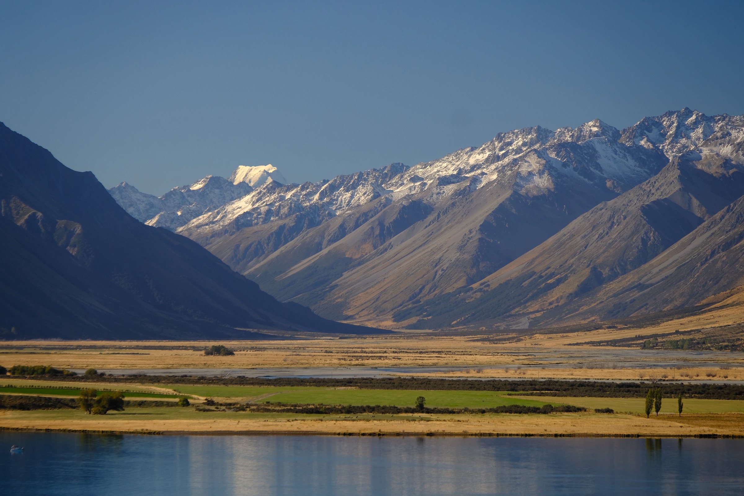
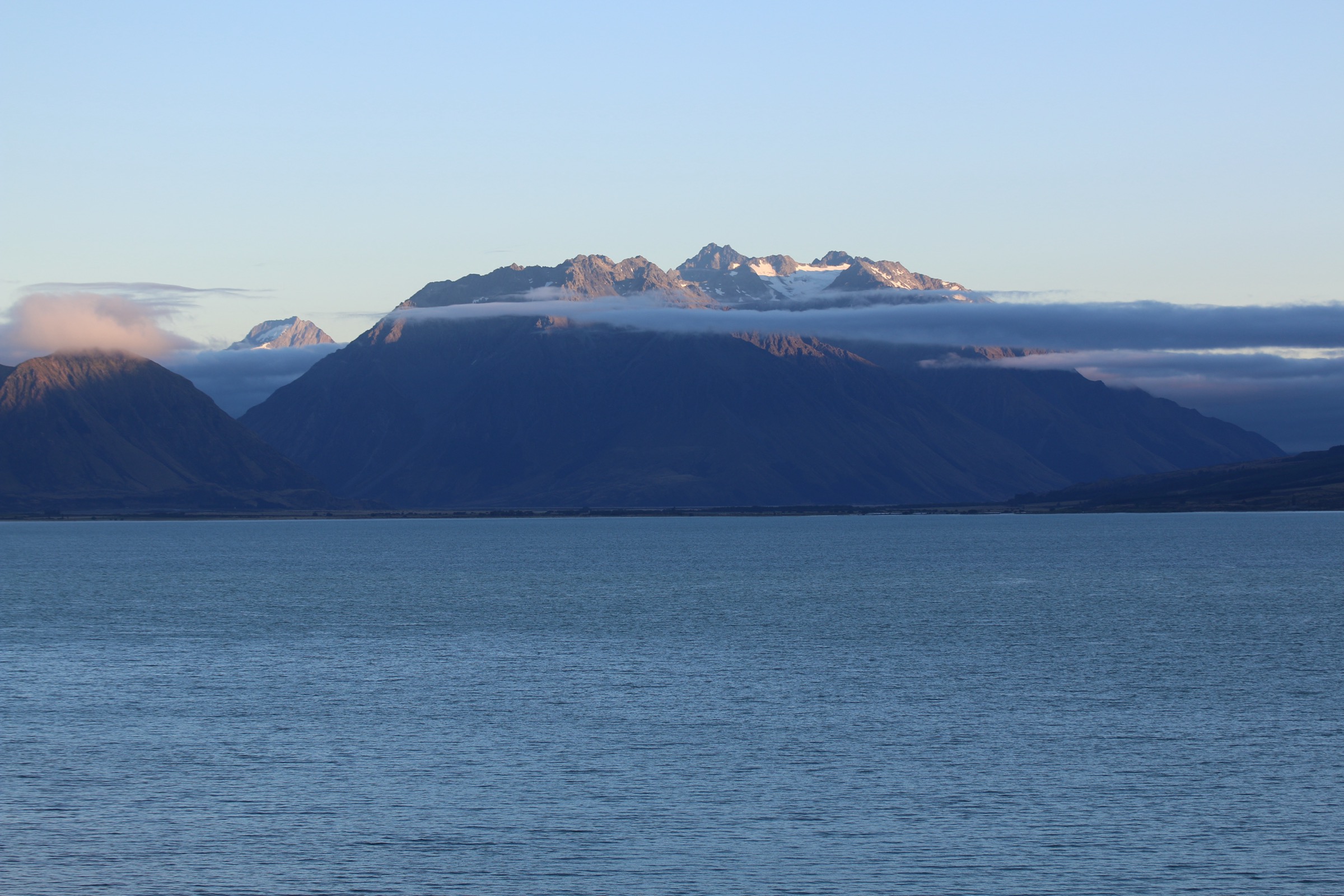
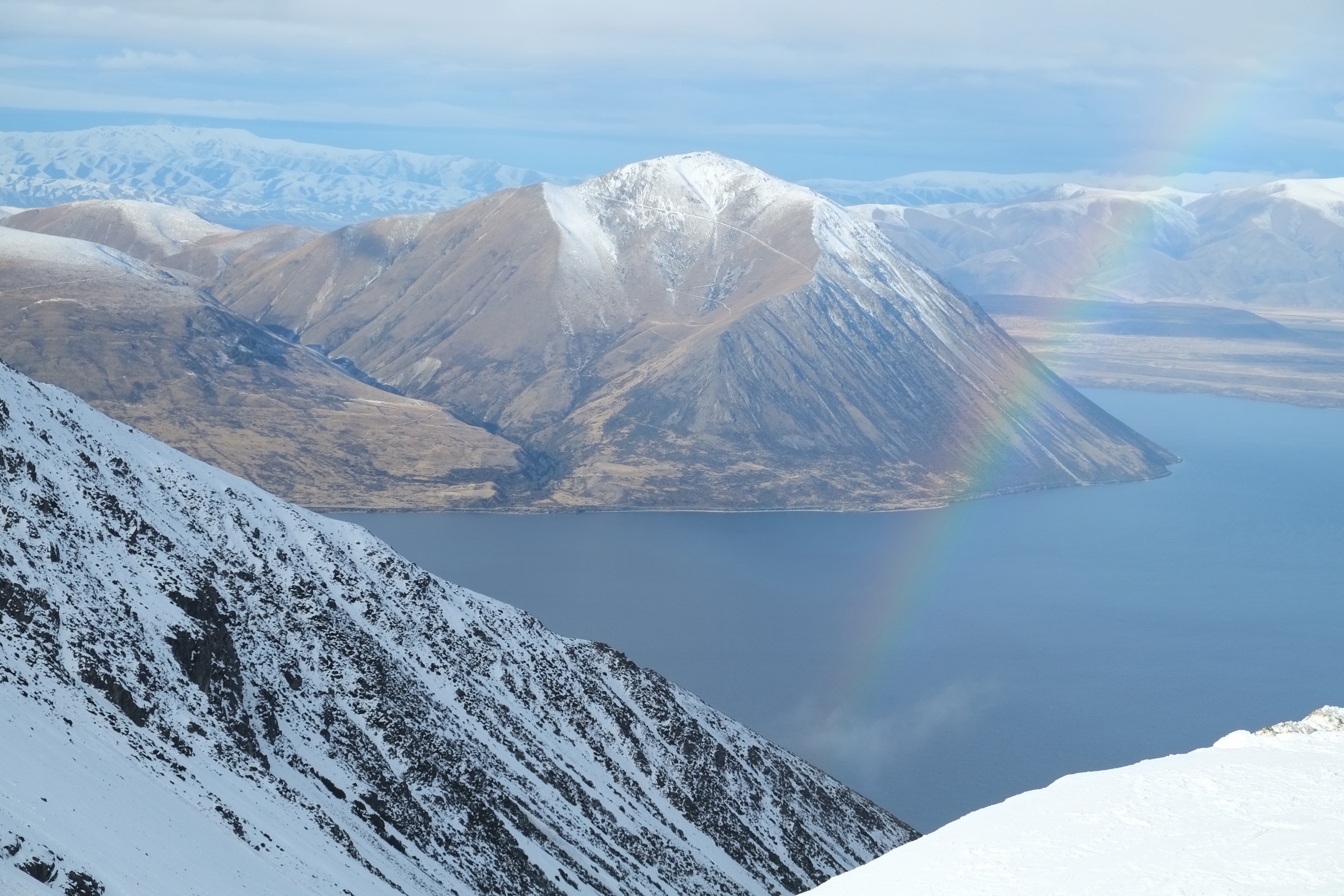
The country falls into red-tussock terraces, beech-fringed glacial moraines and open alpine fells dotted with tarns at around 1,450–1,700 m, rising to broken schist tops in the 1,800–2,000 m band. Hiking centres are minimal. Lake Ōhau Lodge, at the southern end of Lake Ōhau on Lake Ōhau Road, is the main base for the Tarnbrae Track, the Freehold Creek tarns, the Dumb-bell Lake route and the Maitland and Snowy Gorge crossings. Ōmarama, half an hour south, gives road access to the Quailburn end of the Tarnbrae Track and to the Birchwood Road carparks for the Ahuriri-side routes. Twizel, half an hour north, is the supply town and the access town for Glen Lyon Road, which runs up the eastern shore of Lake Ōhau and provides walking-easement access through pastoral leases towards Flanagan Pass, Dorcy Stream and Dart’s Bush at the southern toe of the Ben Ohau Range proper.
Terrain in this sector is mostly open tussock route-finding rather than marked track. Of the five routes selected, only the Tarnbrae Track itself is a fully formed Grade-3 walking track; the others are DOC-acknowledged “routes” or “unmarked routes” on tussock and scree, with intermittent poles or cairns and significant navigation responsibility on the walker. Much of the surrounding flank is on Crown pastoral lease — notably Lake Ōhau Station, Glen Lyon Station, Ben Ohau Station and former Tarnbrae Station, the last of which was purchased into public conservation land by the Nature Heritage Fund and now forms the Ōhau Moraines Wetland Complex inside Ahuriri Conservation Park. Where a route exits or crosses lease land the walker must use a signposted public access easement or obtain explicit permission from the leaseholder; this is most relevant for the Maitland and Snowy Gorge crossings, which require advance contact with Lake Ōhau Station, and for the Glen Lyon Road approaches to Flanagan Pass and Dart’s Bush.
The October 2020 Lake Ōhau wildfire burned roughly 5,000 ha including parts of Ahuriri Conservation Park; vegetation is regenerating but the lower beech and mānuka belts on the Tarnbrae and Sawyers/Parsons tracks remain visibly fire-marked. Summer, December through April, is the standard hiking window. From May into November the high ground holds significant snow and the Tarnbrae Track itself crosses avalanche paths. Weather changes are rapid in the lee of the Main Divide, the tops carry no shelter, and waypoint marking is intermittent at best. Water is plentiful in tarns and creeks above the bushline but should still be treated. Public transport access is effectively zero; shuttles must be coordinated privately from Twizel, Ōmarama or Lake Ōhau Lodge.
Selection rationale
The five routes selected give one example of each main route-type the sector offers, and avoid the iconic Ben Ohau summit (covered in the separate Ben Ohau Area entry) and the lakeshore Lake Ōhau Track (covered in the Lake Ōhau Sector entry). The Tarnbrae Track itself is the only formed walking track that crosses the plateau and is the structural backbone of the sector. The Freehold Creek tarns route to Point 1479 is the classic short tussock route to the chain of alpine tarns and the best photogenic introduction to the tarn-and-ridge character. The Freehold Creek ridge route to Point 1966 is the full ridge day, taking the tarn route on through scree to the watershed for views of Aoraki/Mount Cook and the Barrier Range. The Dumb-bell Lake circuit via Freehold Creek and the Ōhau ski-field road links the largest alpine lake in the area to the established round trip across the central plateau. The Flanagan Pass route via Dorcy Stream is the only easy DOC-listed crossing of the Ben Ohau Range proper from Glen Lyon Road, representative of the Glen Lyon side of the sector and of the pastoral-easement access pattern. A Maitland Hut day option exists from Lake Ōhau Road but is excluded because it requires advance permission from Lake Ōhau Station and the lower track is in poor condition.
Summary
| # | Hike | Country | Route type | Distance | Gain | Max elevation | Difficulty |
|---|---|---|---|---|---|---|---|
| 1 | Tarnbrae Track (Lake Ōhau Lodge to Quailburn Road) | New Zealand | Point-to-point | 16 km | ~460 m | ~900 m | Easy–moderate |
| 2 | Freehold Creek to the 1479 m Tarn | New Zealand | Out-and-back | 13–14 km | ~900 m | ~1,479 m | Moderate |
| 3 | Freehold Creek to Point 1966 ridge | New Zealand | Out-and-back | 18–20 km | ~1,450 m | 1,966 m | Hard |
| 4 | Dumb-bell Lake circuit | New Zealand | Loop / point-to-point | 18–27 km | ~1,500–1,800 m | ~1,900 m | Hard |
| 5 | Flanagan Pass via Dorcy Stream | New Zealand | Out-and-back | ~8 km | ~460 m | 1,225 m | Moderate |
1. Tarnbrae Track (Lake Ōhau Lodge to Quailburn Road)
Snapshot
Itinerary
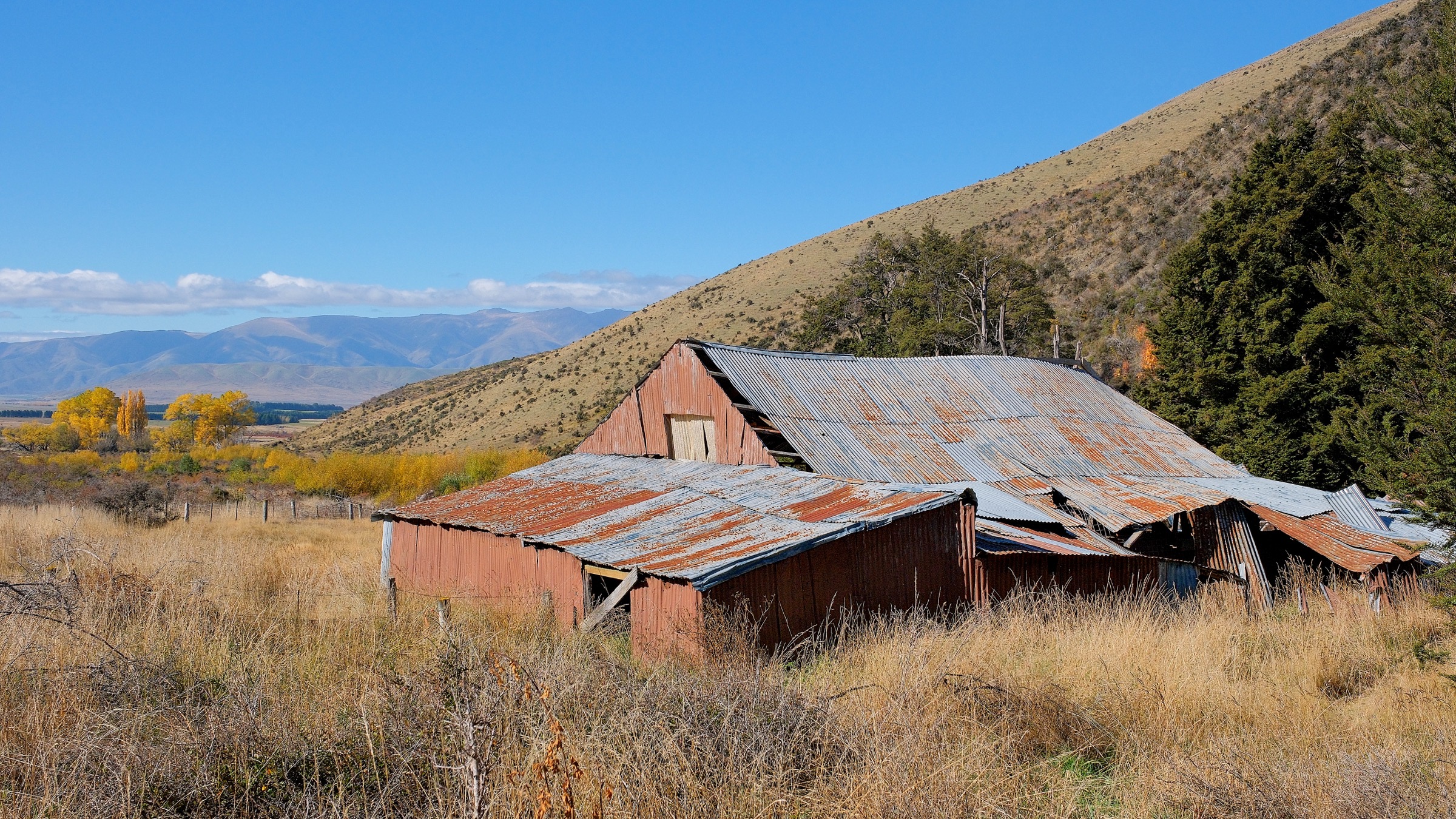
The track starts at Lake Ōhau Lodge at about 540 m and climbs gently north-east into red-tussock terraces above the lake. Within 1 km it joins the Te Araroa / Sawyers Creek route and crosses Sawyers Creek and Parsons Creek on formed bridges. The grade is generous as the track skirts the western foot of the Ōhau Range and threads ancient moraines and dropper-tussock flats. At roughly the 6–7 km mark the track passes a remnant pocket of mountain beech near Freehold Creek, then climbs steadily through open tussock with continuous views west to the Barrier Range and across to the Hopkins–Dobson valleys. The Tarnbrae high point at about 900 m sits 13 km from Lake Ōhau Lodge, on open tops above the head of the Freehold catchment. From here the track descends gradually south-east for 3 km along the edge of the Ōhau Moraines Wetland Complex, passing red-tussock basins and tarn pools, before joining Quailburn Road at the old Quailburn musterers’ homestead and 1866 woolshed site. Most parties walk the route one way with a vehicle shuttle, or turn around at the high point to make a 26 km out-and-back day.
Why it is essential
The Tarnbrae Track is the only formed walking-track traverse of the Tarnbrae plateau and the single most representative route in the sector. It crosses the red-tussock terraces, the moraine-and-wetland country and the beech-bench transition that define the southern Ōhau Range, and it is also the only line of the five hikes that is feasible for fit but non-tramping walkers in summer.
Equipment
- Sturdy boots or supportive trail shoes
- Weatherproof shell and warm mid-layer (the range is fully exposed)
- Sun protection — most of the route is open tussock with no shade
- 2 L or more of water; creeks are reliable but should be treated
- Map (LINZ Topo50 BX15 Lake Ōhau) or GPS
- Headtorch for the long-day variant
- Trekking poles useful on the moraine descent
- Avalanche awareness, transceiver, probe and shovel for any winter or shoulder-season attempt; DOC explicitly warns of avalanche paths crossing the track from May into November
Hazards and notes
- The track is part of the Alps 2 Ocean cycle trail between Lake Ōhau Lodge and Quailburn Road; walkers must be alert at corners and on narrow benched sections.
- Several drainages cross avalanche paths in winter and spring.
- Long exposed sections leave no shelter from wind, sun or rain.
- Dogs are not permitted.
- Cell coverage is patchy at best.
- The fire-burned beech and mānuka belts near Freehold Creek are still recovering — keep to the formed line.
Routes and maps
| Source | URL |
|---|---|
| DOC — Tarnbrae Track A2O | doc.govt.nz |
| DOC — Sawyers and Parsons Creek to Freehold Creek Track | doc.govt.nz |
| Alps 2 Ocean — Section 4 Lake Ōhau Lodge to Ōmarama | alps2ocean.com |
| OpenStreetMap — Lake Ōhau to Quailburn alignment | openstreetmap.org |
External links
- DOC — Ōhau Moraines Wetland Complex
- DOC — Quailburn historic site
- DOC — Ahuriri Conservation Park brochure (PDF)
2. Freehold Creek to the 1479 m Tarn
Snapshot
Itinerary
From the Parsons Creek car park on Lake Ōhau Road the route follows the Sawyers and Parsons Creek to Freehold Creek Track north-west along moraine terraces. After approximately 6 km, or two to three hours, it joins the Te Araroa Trail at Freehold Creek and turns west, climbing steadily through remnant mountain beech up the true left of Freehold Creek. At the bushline a DOC sign marks diverging routes: the marked Te Araroa option with orange poles heads west to the East Ahuriri saddle, while the unmarked tarn route, with intermittent yellow poles, bends right and follows a small side-creek out of the trees into a high tussock basin. The track here is faint but largely follows the natural line; the basin opens onto Point 1479, a sheltered tarn cradled below the main Ōhau Range ridge. Return on the same line. Confident parties extend the day a further 300 m of climb to a second, larger tarn nestled under Point 1922 on the western side of the tops, the route described as Hike 3.
Why it is essential
The 1479 m tarn is the most accessible representative of the chain of small alpine tarns that gives this sector its character. It sits at the transition between beech, tussock and broken alpine tops, and on a clear day it shows the Barrier Range across the Dobson valley and the upper end of Lake Ōhau. It is the standard first day on the Tarnbrae tops for parties not committing to the full ridge or Dumb-bell Lake.
Equipment
- Sturdy boots
- Weatherproof shell, warm layer, hat and gloves
- Map (LINZ Topo50 BX15 Lake Ōhau) and compass or GPS
- 2 L water; treat above bushline
- Sun protection
- Trekking poles useful for the bush descent
Hazards and notes
- The route above the Te Araroa junction is unmarked and easy to lose in cloud; the open tussock basins above the bushline drain in several directions and recovery from a wrong line costs serious time.
- Streams can swell quickly in rain.
- The lower track crosses land affected by the 2020 Lake Ōhau fire and the beech is windthrow-prone.
- Dogs are not permitted on the Te Araroa or DOC tracks here.
- Cell coverage is absent above the bushline.
Routes and maps
| Source | URL |
|---|---|
| DOC — Sawyers and Parsons Creek to Freehold Creek Track | doc.govt.nz |
| Tussock.rocks — Point 1966 via Freehold Creek (lower section) | tussock.rocks |
| Wilderness Magazine — Freehold Creek Tarns | wildernessmag.co.nz |
| NOTMC — Freehold Creek to Tarns 1479 m | notmc.org.nz |
External links
- Te Araroa Trail — Canterbury section (northbound notes)
- Wilderness Magazine — Freehold Creek Tarns trip
3. Freehold Creek to Point 1966 ridge

Snapshot
Itinerary
The lower 6 km follow the Sawyers / Parsons access track to the Freehold Creek junction described in Hike 2. From there the route climbs on the marked Te Araroa line to the bushline, then takes the right-hand (north) route into the high tussock basin and the 1479 m tarn. From the tarn the route climbs roughly 300 m on a tussock spur to the second, larger tarn cradled beneath Point 1922. From there it sidles up scree onto the saddle between Points 1834 and 1922, a relatively straightforward but loose section in good conditions. From the saddle the ridge runs gently north along the main watershed; Point 1966 is reached by an easy walk along open tops from Point 1834. The ridge top opens views east to Lake Ōhau and the Mackenzie Basin, north to Aoraki/Mount Cook on a clear day, and west across the Dobson valley to the Barrier Range. Return is by the ascent line; descending an alternative spur is not recommended due to bluffed-out features east of Point 1834.
Why it is essential
This is the natural ridge day of the sector. It links the tarn-chain character of the Tarnbrae plateau to the broader Ōhau watershed and offers the highest accessible vantage point on the central plateau without requiring permission across pastoral lease land. It captures the representative scree-and-tussock alpine character of the range.
Equipment
- Sturdy boots
- Weatherproof shell, insulated layer, warm hat and gloves (tops are cold and windy even in summer)
- Sun protection (high UV at altitude)
- 2–3 L water; creeks above bushline reliable
- Map (LINZ Topo50 BX15 Lake Ōhau) and compass plus GPS
- Headtorch
- Trekking poles recommended
- Emergency bivy bag and personal locator beacon recommended given the cell shadow
Hazards and notes
- Long route, fully exposed for the upper two-thirds.
- Scree on the 1834–1922 saddle is loose and slips can be serious.
- Weather can deteriorate within an hour from the Tasman Sea side; turn back at the bushline if cloud is on the tops.
- Snow lingers in the upper basins into late December.
- No huts on route.
- Dogs are not permitted on the DOC / Te Araroa section.
Routes and maps
| Source | URL |
|---|---|
| Tussock.rocks — Point 1966 via Freehold Creek | tussock.rocks |
| NZ Route Guides — Freehold Creek North Branch tarns | routeguides.co.nz |
| Wilderness Magazine — Freehold Creek Tarns (lower approach) | wildernessmag.co.nz |
| DOC — Sawyers and Parsons Creek to Freehold Creek Track | doc.govt.nz |
External links
4. Dumb-bell Lake circuit via Freehold Creek and the Ōhau ski-field road
Snapshot
Itinerary
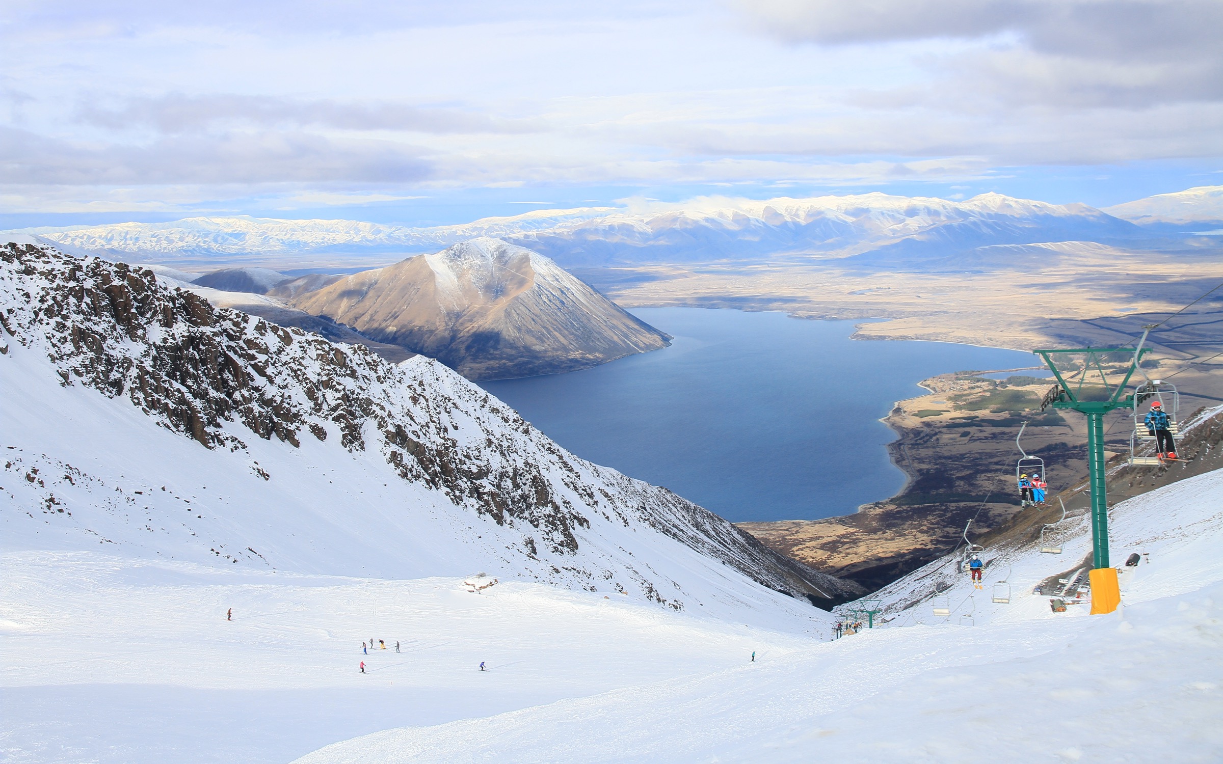
From the Parsons Creek car park the route follows the Sawyers / Parsons access track and the Te Araroa line to the Freehold Creek bushline at about 6 km, then takes the right-hand tarn route to Point 1479 — a further 1.5 km. From the upper tarn under Point 1922 it climbs scree to the ridge separating the Ōhau basin from Snowy Gorge. Instead of following the ridge to Point 1966, as in Hike 3, the route turns north and contours the tops past several small alpine tarns to the broad open basin above Dumb-bell Lake. The lake, at about 1,700 m, is a striking double-lobed alpine tarn under the Ōhau watershed peaks and the largest standing water on this side of the range. From Dumb-bell the route drops south-east onto the head of the Ōhau Snow Fields ski field via a steep rocky descent: approximately 450 m of loss in 1 km over scree and bluffy steps on a cairn line. From the top of the chairlift the ski-field service road descends about 9 km to Lake Ōhau Lodge, a stage best shuttled if possible. The full on-foot circuit is approximately 27 km.
Why it is essential
Dumb-bell Lake is the named alpine waterbody of the sector and the longest-established off-track day in the area. The circuit links the Freehold tarn chain, the watershed ridge and the ski-field bowls — three of the defining landscapes of the central Ōhau Range — in a single day.
Equipment
- Sturdy boots
- Weatherproof shell, insulated layer, warm hat and gloves
- 3 L water; treat at all altitudes
- Map (LINZ Topo50 BX15 Lake Ōhau) and compass plus GPS
- Headtorch (essential; the route often ends in twilight)
- Trekking poles recommended on the ski-field descent
- Personal locator beacon and emergency bivy bag recommended
- Helmet optional for the scree-bluff descent into the ski field
Hazards and notes
- The descent from the watershed ridge into the top of the ski field is the hardest section: ~450 m of elevation loss in roughly 1 km over loose rock with route-finding required between bluffs.
- Snow lingers in the Dumb-bell basin into January in heavier years.
- The route traverses the active Ōhau Snow Fields ski-field boundary; in winter it is closed to walkers.
- Camping is permitted in Ahuriri Conservation Park (including near Dumb-bell Lake) and the route can be extended overnight.
- Dogs are not permitted.
Routes and maps
| Source | URL |
|---|---|
| Churn New Zealand — Dumb-bell Lake Hike (route + GPX) | churnewzealand.com |
| Wild Things — Dumb-bell Lake Loop | wildthings.club |
| ClimbNZ — Ōhau to Dumb-bell Lake Traverse | climbnz.org.nz |
| Wilderness Magazine — Maitland Hut via Dumb-bell | wildernessmag.co.nz |
External links
- DOC — Ahuriri Conservation Park brochure (PDF)
- NOTMC — Maitland Hut / Dumb Bell Lake
- Ski Touring NZ — Ben Ohau Haute Route
5. Flanagan Pass via Dorcy Stream
Snapshot
Itinerary
From Glen Lyon Road on the west side of Lake Ōhau, the signposted public-access easement leaves the road just before Dorcy Stream. A rough 4WD track on the true left of the stream climbs through pastoral lease land to a disused airstrip — about 4 km and 460 m of climb. Walkers may park at the road and walk the 4WD section, or, where conditions allow, drive a high-clearance 4WD up to the airstrip. From the airstrip parking an unmarked tussock route continues up open slopes towards the saddle of Flanagan Pass at 1,225 m, taking around 1 hour 30 minutes. The pass sits on the main watershed of the Ben Ohau Range and gives the simplest documented crossing between the Lake Ōhau (Glen Lyon) side and the Twizel (eastern) flank. Views open both ways: west to Lake Ōhau and the Barrier Range, east across the broad Twizel river country to the Two Thumb Range. The standard day is to turn around at the pass. An extended option descends to Dart’s Bush via a second signposted walking easement, but coordination with the lease holder is recommended for any extended through-route.
Why it is essential
Flanagan Pass is the only DOC-listed, signposted-easement crossing of the Ben Ohau Range proper that is feasible as a half-day to day walk, and is representative of the Glen Lyon Road access pattern characteristic of this sector. It exemplifies the pastoral-lease access landscape and is the only route in the five that approaches from the east-Twizel side of the range.
Equipment
- Sturdy boots
- Weatherproof shell and warm layer
- Map (LINZ Topo50 BX15 Lake Ōhau or BX14) and compass or GPS
- 2 L water; treat creek water
- Sun protection; the route is fully exposed above the airstrip
- Trekking poles helpful on the rough 4WD section
Hazards and notes
- The route uses public-access easements through pastoral lease farmland; dogs are not permitted on the marked easements without landholder permission, and walkers must keep to the easement line.
- The 4WD section can be treacherous in winter or heavy rain.
- The upper route is unmarked tussock with no shelter; weather on the pass changes rapidly.
- There is no hut at the pass.
- The Dart’s Bush extension and the Fraser Stream easement are separate signposted easements off Glen Lyon Road and should not be treated as interconnected without prior arrangement.
Routes and maps
| Source | URL |
|---|---|
| DOC — Dorcy Stream 4WD road | doc.govt.nz |
| DOC — Flanagan Pass Trail (Twizel area) | doc.govt.nz |
| ClimbNZ — Flanagan Pass | climbnz.org.nz |
| DOC — Ben Ohau hunting block (easement and access notes) | doc.govt.nz |
External links
External links
- DOC — Ahuriri Conservation Park
- DOC — Ruataniwha Conservation Park (Twizel area)
- DOC — Ahuriri Conservation Park brochure (PDF)
- Alps 2 Ocean Cycle Trail
- Te Araroa Trail — Canterbury
- LINZ — Ben Ohau pastoral lease information
- Fire and Emergency NZ — Lake Ōhau Wildfire Investigation Report
- Wikipedia — Ben Ohau Range
- Wikipedia — Lake Ōhau