Regional overview
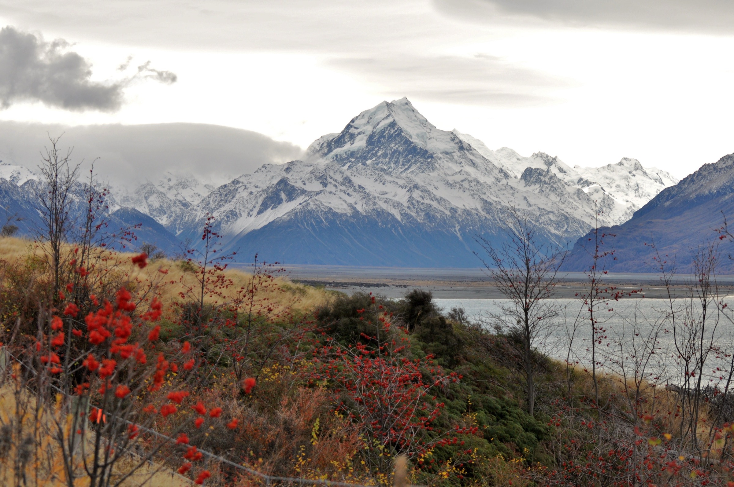
The Ben Ohau Area covers the northern end of the Ben Ohau Range — the long, north–south greywacke wall that separates the Dobson and Hopkins valleys to the west from the Mackenzie Basin to the east. The eponymous peak Ben Ōhau / Te Ruataniwha, recorded at 1,522 m on LINZ Topo50 mapping (older signage and some guidebooks cite 1,552–1,557 m), anchors the southern end of the range proper but functions visually as the iconic frontal summit seen from Twizel, Lake Pukaki and the tussock basin in between. The lower slopes are high-country pastoral terrain — heavily used merino runs such as Glen Lyon, Ben Ohau Station and Ferintosh — giving way abruptly to scree, snow-tussock and rocky tops above about 1,200 m. Much of the upper range sits inside or adjacent to Ruataniwha Conservation Park, with several Department of Conservation (DOC) tracks crossing walking easements through private high-country leases.
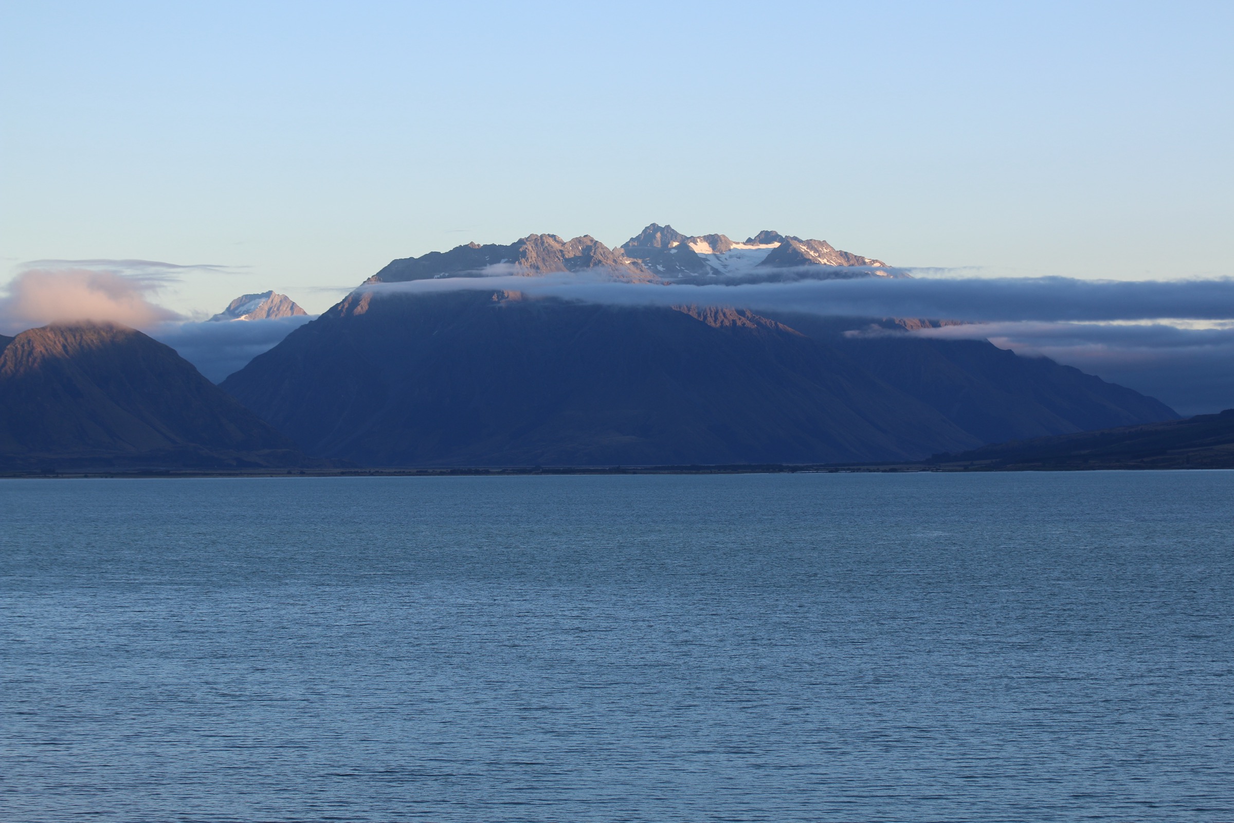
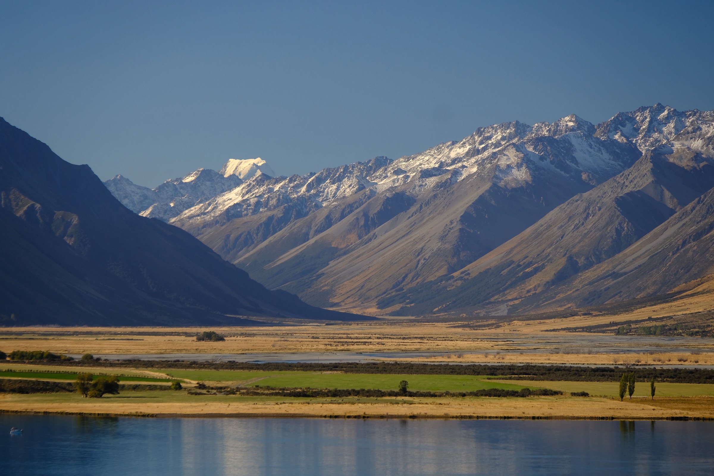
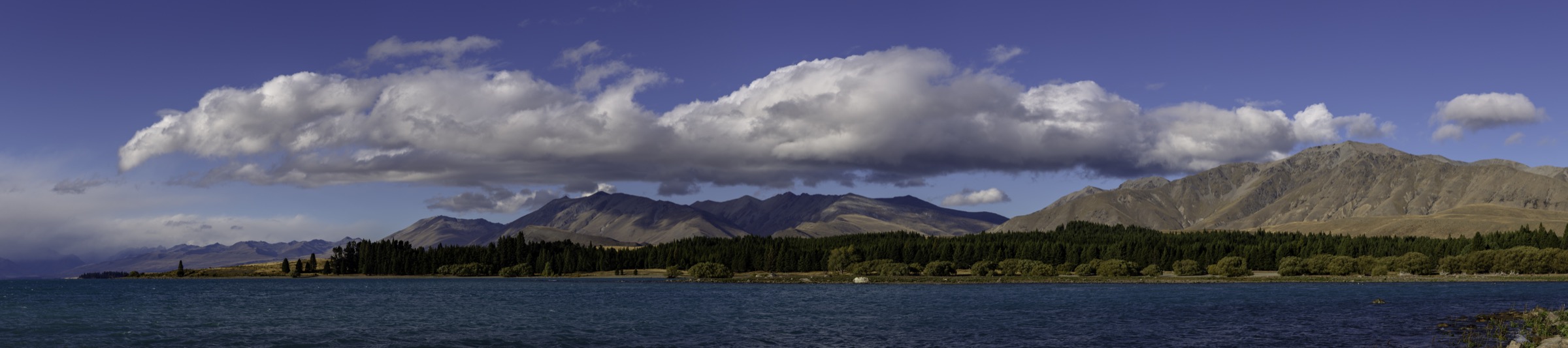
The main hiking centre is Twizel (470 m), a hydro-construction town built in 1968 for the Upper Waitaki Power Scheme. From Twizel, a single road — Glen Lyon Road — climbs north-west along the Pukaki–Ohau canal corridor and provides every trailhead in this sub-region. State Highway 8 north of Twizel skirts the southern shore of Lake Pukaki, and SH80 then runs up the Tasman Valley to Aoraki / Mount Cook Village. The Alps 2 Ocean Cycle Trail also passes through the area and offers several walking-friendly sections. Terrain is mostly open tussock and farmland on the lower slopes, with exposed scree and rock above. There are no glaciers within the sub-region itself, but the high tops yield panoramic views of Aoraki / Mount Cook, the Tasman Glacier, the Liebig Range and the entire Mackenzie Basin. The eastern flank carries very little shade and very little water in summer; the western flank (Greta Stream and the Flanagan Pass approach) holds snow into late spring.
The reliable season for the tops runs from roughly mid-November to mid-April. Winter conditions on the Ben Ohau ridge are genuinely alpine: snow lies above about 1,100 m, the summit ridge is fully exposed to north-westerly storms (the te reo Māori “ō hau” itself meaning “of the wind”), and ice axe and crampons are sometimes required. Lower-elevation walks — the Pukaki Foreshore, Marker Bay, the Kettle Hole Track — remain accessible year-round. Several tracks cross walking easements over working high-country stations; dogs are generally not permitted, gates must be left as found and stock should not be disturbed. Cell coverage is patchy across the basin and absent on the upper mountain.
Selection rationale
The five hikes were chosen to give a balanced picture of the northern Ben Ohau Range and its surrounding lake basins: the eponymous summit on a marked track (Ben Ōhau Peak via the Greta Track loop); the lowest tramping-grade crossing of the range (Flanagan Pass), which gives a transverse view of both the Mackenzie Basin and the Lake Ōhau side; a Twizel-side easement to a panoramic saddle (Pyramid Track to Pyramid Saddle); the Te Araroa section along the southern shore of Lake Pukaki (Lake Pukaki Foreshore Walkway), which provides the most accessible foot-level view of the range from the east; and the standard kettle-moraine introductory walk south of the Pukaki dam (Pukaki Kettle Hole Track combined with the Marker Bay spur). Mount Mary (1,841 m further north along the crest) was considered but excluded as a separate entry — no marked or maintained DOC track ascends Mount Mary directly, and the standard approach is via Flanagan Pass and off-track ridge travel, which is folded into the Flanagan Pass entry.
Summary
| # | Hike | Country | Route type | Distance | Gain | Max elevation | Difficulty |
|---|---|---|---|---|---|---|---|
| 1 | Ben Ōhau Peak via Greta Track | New Zealand | Loop (with summit spur) | ~16 km | ~1,050 m | 1,522 m | Hard |
| 2 | Flanagan Pass Track | New Zealand | Out-and-back | ~23 km return | ~760 m | 1,225 m | Hard |
| 3 | Pyramid Track (to Pyramid Saddle) | New Zealand | Out-and-back | ~14.5 km | ~340 m | ~830 m | Moderate |
| 4 | Lake Pukaki Foreshore Walkway | New Zealand | Out-and-back | ~13 km | <100 m | ~520 m | Easy |
| 5 | Pukaki Kettle Hole Track + Marker Bay | New Zealand | Loop + spur | ~4–5 km | ~80 m | ~570 m | Easy |
1. Ben Ōhau Peak via Greta Track
Snapshot
Itinerary
The signposted trailhead lies at the end of Glen Lyon Road on the eastern shore of Lake Ōhau, reached by following Glen Lyon Road from Twizel along the Pukaki and Ohau canals (about 23 km, sealed for the first stretch and narrow unsealed for the final section). DOC marks the track on both sides of Greta Stream and the loop is typically walked clockwise — south branch first — for a gentler ascent. The lower track starts as a grassy 4WD-grade easement, passing Back Hut, a derelict musterer’s hut dating from the 1890s, before climbing steadily up the western flank of the peak. It gains around 1,000 m over roughly 5 km, switchbacking through tussock and matagouri with occasional scree benches. Above the bushline (in practice, immediately, since this is open tussock country), the marked track ends and walkers branch right onto a clear foot pad through scree and snow-tussock for the final ~150 m of climb to the trig at 1,522 m. The summit gives a 360° panorama across Lake Ōhau, Lake Pukaki, Lake Ruataniwha, the Aoraki / Mount Cook massif, the Hopkins–Dobson valleys and, on a clear day, the Glen Mary Glacier on the western side of Mount Glenmary.
The descent follows the northern Greta Stream branch of the loop, dropping steeply at first then flattening into the stream itself. The lower section requires several unbridged crossings of Greta Stream and wet feet should be expected. The track returns to Glen Lyon Road a short distance from the start car park.
Why it is essential
Ben Ōhau / Te Ruataniwha is the eponymous summit of the range and the most visible peak from Twizel, Lake Pukaki and the wider Mackenzie Basin. It is the only summit in the sub-region reachable on a marked track in a day. The view from the top is widely regarded as one of the finest accessible alpine panoramas in inland Canterbury, taking in three major glacial lakes, the Aoraki massif and the Hopkins headwaters.
Equipment
- Sturdy mountain boots
- Trekking poles recommended for the descent
- Extra warm layer and wind-shell
- Hat and gloves outside midsummer
- Map and GPS (LINZ Topo50 BX15 Ōhau)
- 2 L water minimum — no reliable water above Greta Stream
- Sun protection (no shade on the route)
- Headtorch for a long day
- Conditional: ice axe and microspikes for residual snow November–December and April–May
Hazards and notes
- Fully exposed to north-west weather; the summit ridge is notoriously windy.
- The summit spur is unmarked and easily lost in cloud.
- Several unbridged crossings of Greta Stream; avoid after heavy rain.
- The lower section crosses pastoral lease land — dogs are not permitted, gates must be left as found and stock should not be disturbed.
- No cell coverage on the upper mountain.
- The area is a DOC hunting block; check ballot status during the roar (late March to April).
Routes and maps
| Source | URL |
|---|---|
| DOC — Greta Track, Ruataniwha Conservation Park | doc.govt.nz |
| PlanMyWalk NZ — Greta Track | planmywalk.nz |
| Wikiloc — Ben Ohau und Greta Track | wikiloc.com |
| OpenStreetMap — Greta Track | openstreetmap.org |
External links
- Freewalks.nz — Ben Ohau Peak Walk
- Wilderness Magazine — Greta Track, Ruataniwha Conservation Park
- ClimbNZ — Te Ruataniwha / Ben Ohau
2. Flanagan Pass Track
Snapshot
Itinerary
The Flanagan Pass Track branches off the lower Greta Stream Track on the eastern (Mackenzie Basin) side of the range. The route follows Greta Stream for a short distance and then turns west onto a marked tramping track that climbs steadily across the lower flanks of the range, crossing three unbridged streams, before steepening into the basin below the pass. From the head of the basin the track follows tussock benches and zig-zags up to the obvious notch at 1,225 m, with sweeping views back over Lake Pukaki and across to Aoraki / Mount Cook. The pass itself sits between Ben Ōhau and Mount Mary (1,841 m) further north along the crest, and reveals the western side of the range with Lake Ōhau and the Dobson and Hopkins valleys below.
A common variant continues down the Old Dorcy 4WD road on the western side to the Old Dorcy Airstrip (a further descent of about an hour and a half) and either retraces, arranges a vehicle shuttle via Lake Ōhau Road, or — with the right transport logistics — combines with the Dorcy Stream 4WD road for a long traverse to Lake Ōhau. Most parties simply return over the pass to the Greta Track car park.
Why it is essential
Flanagan Pass is the lowest gap in the Ben Ohau Range and the only tramping-grade crossing in the sub-region. It gives the classic Mackenzie crossing experience — open snow-tussock, big-sky high country and a panoramic transverse view of both the eastern Mackenzie Basin and the western Dobson / Lake Ōhau side. The pass also provides an alternative day on the same trailhead as Ben Ōhau Peak for parties spending several days in the area.
Equipment
- Sturdy mountain boots
- Trekking poles for stream crossings and scree
- Extra warm layer and wind-shell
- Map and GPS (LINZ Topo50 BX15)
- 2 L water minimum
- Sun protection
- Gaiters useful for matagouri and tussock
- Conditional: ice axe in early season; the pass holds residual snow into November
Hazards and notes
- Three unbridged stream crossings — impassable after heavy rain.
- Part of the route crosses pastoral lease easements; gates must be left as found and dogs are not permitted.
- The track is marked but lightly travelled; route-finding above the basin requires confidence in poor visibility.
- Hunting block — check DOC ballots during the roar.
- No cell coverage on the upper route.
Routes and maps
| Source | URL |
|---|---|
| DOC — Flanagan Pass Trail | doc.govt.nz |
| DOC — Dorcy Stream 4WD road | doc.govt.nz |
| AllTrails — Flanagan’s Pass Track | alltrails.com |
| WalkingKiwi — Flanagan Pass Trail | walkingkiwi.co.nz |
External links
- ClimbNZ — Flanagan Pass
- North Otago Tramping and Mountaineering Club — Ben Ohau trip reports
- DOC — Ruataniwha Conservation Park
3. Pyramid Track to Pyramid Saddle
Snapshot
Itinerary
From the car park on Glen Lyon Road just past the Pukaki canal bridge, the easement begins on a marked 4WD-grade farm track. It crosses pastoral lease land and passes the small Ben Ohau Wetland (a short signposted spur) before climbing gently across the tussock-and-pine flanks of the northern Ben Ohau spurs. The track switchbacks up to Pyramid Saddle at approximately 830 m, a broad open col with sustained views east across the Mackenzie Basin to Lake Pukaki, the Two Thumb Range and the Aoraki massif. From the saddle the easement descends gently on the western side to Dart’s Bush Stream, where the conservation boundary is marked. Walkers usually turn around here and return to the trailhead; an unbridged crossing at Dart’s Bush Stream is required to continue the full distance.
Why it is essential
The Pyramid Track is the standard moderate-grade day-hike from Twizel and provides the closest “ridge-level” view of the Ben Ohau Range tops and the wider Mackenzie Basin without the commitment of a full alpine summit. The eastward panorama from the saddle is the best accessible composition of Aoraki / Mount Cook framed by the Ben Ohau spurs.
Equipment
- Hiking shoes or light boots
- Weatherproof and warm layer
- Water (1.5 L; no reliable source on the climb)
- Sun protection (very little shade)
- Map and GPS
- Insect repellent useful in late spring
Hazards and notes
- The easement crosses Ben Ohau Station pastoral lease land — dogs are not permitted, gates must be left as found and stock should not be disturbed.
- Dart’s Bush Stream is unbridged and may be impassable after heavy rain.
- Fully open to north-west weather; afternoon thunderstorms possible in summer.
- Shared with mountain bikers and (rarely) horse riders.
- No cell coverage on the upper saddle.
Routes and maps
| Source | URL |
|---|---|
| DOC — Pyramid Track | doc.govt.nz |
| PlanMyWalk NZ — Pyramid Track | planmywalk.nz |
| AllTrails — Pyramid Track | alltrails.com |
| Trailforks — Pyramid Track | trailforks.com |
External links
- DOC — Twizel area tracks
- Singletracks — Pyramid Saddle Mountain Bike Trail
- Twizel Hard Labour Weekend — Pyramid Run
4. Lake Pukaki Foreshore Walkway
Snapshot
Itinerary
The walkway runs along the southern and eastern foreshore of Lake Pukaki and forms part of the Te Araroa long-distance trail. The route can be joined at several points on the lake side of State Highway 8 between the Lake Pukaki dam and the SH80 turn-off to Aoraki / Mount Cook Village; the most popular start is at the Pūkaki spillway car park immediately west of the dam, beside the Marker Bay short walk. The track itself is a mix of 4WD-width farm road and grassed lakeshore terrace, with no significant elevation change. The view-line is dominated by the Ben Ohau Range above the western shore and, on clear days, by Aoraki / Mount Cook at the head of the lake some 50 km north. There is no shade anywhere on the route and no reliable water along the foreshore.
A standard return walk turns around at about 6.5 km, giving a ~13 km day. Through-walkers on Te Araroa continue around the eastern shore toward the Tasman Valley and the Hooker Valley terraces.
Why it is essential
The Foreshore Walkway is the most accessible foot-level view of the Ben Ohau Range from the east, the canonical Aoraki / Lake Pukaki vista, and a recognised section of Te Araroa. It provides the gentle lake-shore counterpart to the high-country summits and ridges of the same sub-region and is the only essentially flat day-hike with sustained Ben Ohau Range views.
Equipment
- Hiking shoes
- Sun protection (no shade)
- Hat and wind-shell — lake-effect winds can be strong
- Water — at least 1.5 L; none on route
- Map and GPS (optional)
Hazards and notes
- Fully exposed to sun and wind with no shelter.
- Lake water is cold (typically 3–6 °C) and the shoreline is steep and unstable in places — not a safe swimming location.
- Sections cross pastoral lease easements; gates must be left as found and dogs must be on lead where signposted (and excluded entirely on some sections).
- Lupin flowering season (mid-November to December) sees high visitor numbers and roadside parking congestion on SH8.
Routes and maps
| Source | URL |
|---|---|
| Te Araroa Trust — long-distance trail GPX bundle | teararoa.org.nz |
| DOC — Lake Pukaki area | doc.govt.nz |
| Freewalks.nz — Lake Pukaki Foreshore Walk | freewalks.nz |
| OpenStreetMap — Te Araroa relation 1455949 | openstreetmap.org |
External links
- MackenzieNZ — Short Walks At Lake Pūkaki
- Te Araroa Trust — section descriptions
- Wikipedia — Lake Pukaki
5. Pukaki Kettle Hole Track + Marker Bay loop
Snapshot
Itinerary
The Pukaki Kettle Hole Track leaves a signposted car park on the southern side of SH8 immediately south of the Lake Pukaki dam, about ten minutes’ drive from Twizel. It runs as a gravelled loop of approximately 4 km across the lateral and terminal moraine deposits left by the last advance of the Pukaki Glacier, circling a textbook kettle hole roughly 300 m wide and up to 60 m deep, with a small pond at its base. Total elevation gain is around 80 m, spread over gentle moraine undulations.
The Marker Bay short track begins at a separate car park about 200 m to the north on SH8, immediately before the Pukaki dam, and follows a 1 km gravelled path through pine to a quiet bay where the original Lake Pukaki settlement once stood before being flooded as part of the hydro scheme. The two walks are commonly combined as a single 1.5–2 hour outing. Both tracks share a near-identical view-line: across Lake Pukaki, the entire eastern face of the Ben Ohau Range fills the western horizon, with Aoraki / Mount Cook at the head of the lake to the north.
Why it is essential
The Kettle Hole Track is the standard introduction to the geology of the Mackenzie Basin — a textbook example of a kettle moraine formed by stagnant glacial ice — and is the most visited short walk in the immediate Twizel area. It also gives the most photographed eastern panorama of the Ben Ohau Range and Aoraki, complementing the inland summit and ridge walks elsewhere in this sub-region. Combined with the Marker Bay spur it forms a culturally significant pairing: the kettle moraine for the natural history, Marker Bay for the social history of the hydro scheme.
Equipment
- Walking shoes (formed gravel surface)
- Sun and wind protection
- Water (1 L)
- Camera
- Light warm layer outside summer
Hazards and notes
- The kettle hole edge is unfenced — keep back from the rim.
- The track is open to walkers and cyclists; dogs are permitted on lead.
- Very high visitor numbers in summer; arrive early or late for parking.
- No facilities at the car park beyond a sign and rubbish bin.
Routes and maps
| Source | URL |
|---|---|
| DOC — Pukaki Kettle Hole Track | doc.govt.nz |
| DOC — Marker Bay Track | doc.govt.nz |
| PlanMyWalk NZ — Pukaki Kettle Hole Track | planmywalk.nz |
| AllTrails — Pukaki Kettle Hole Track | alltrails.com |