Regional overview
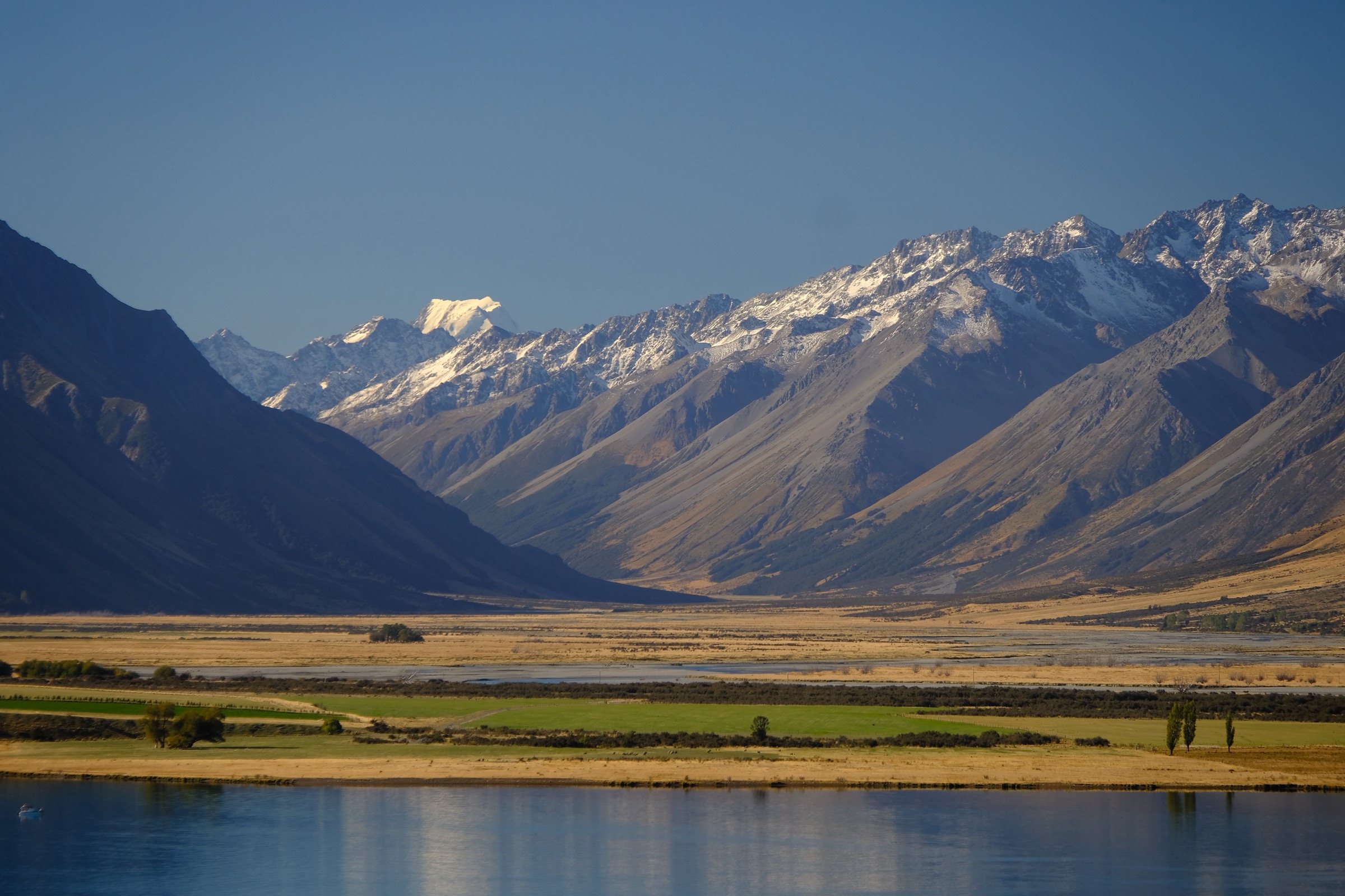
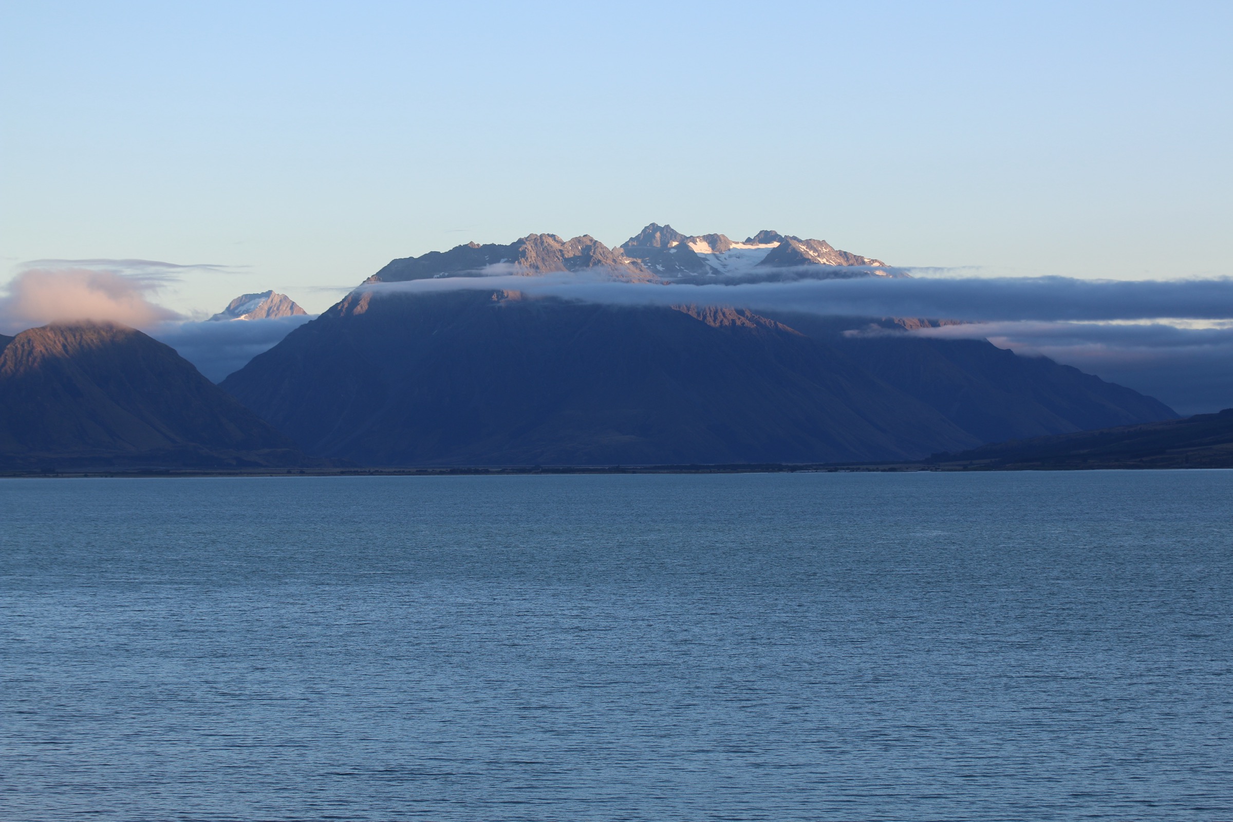
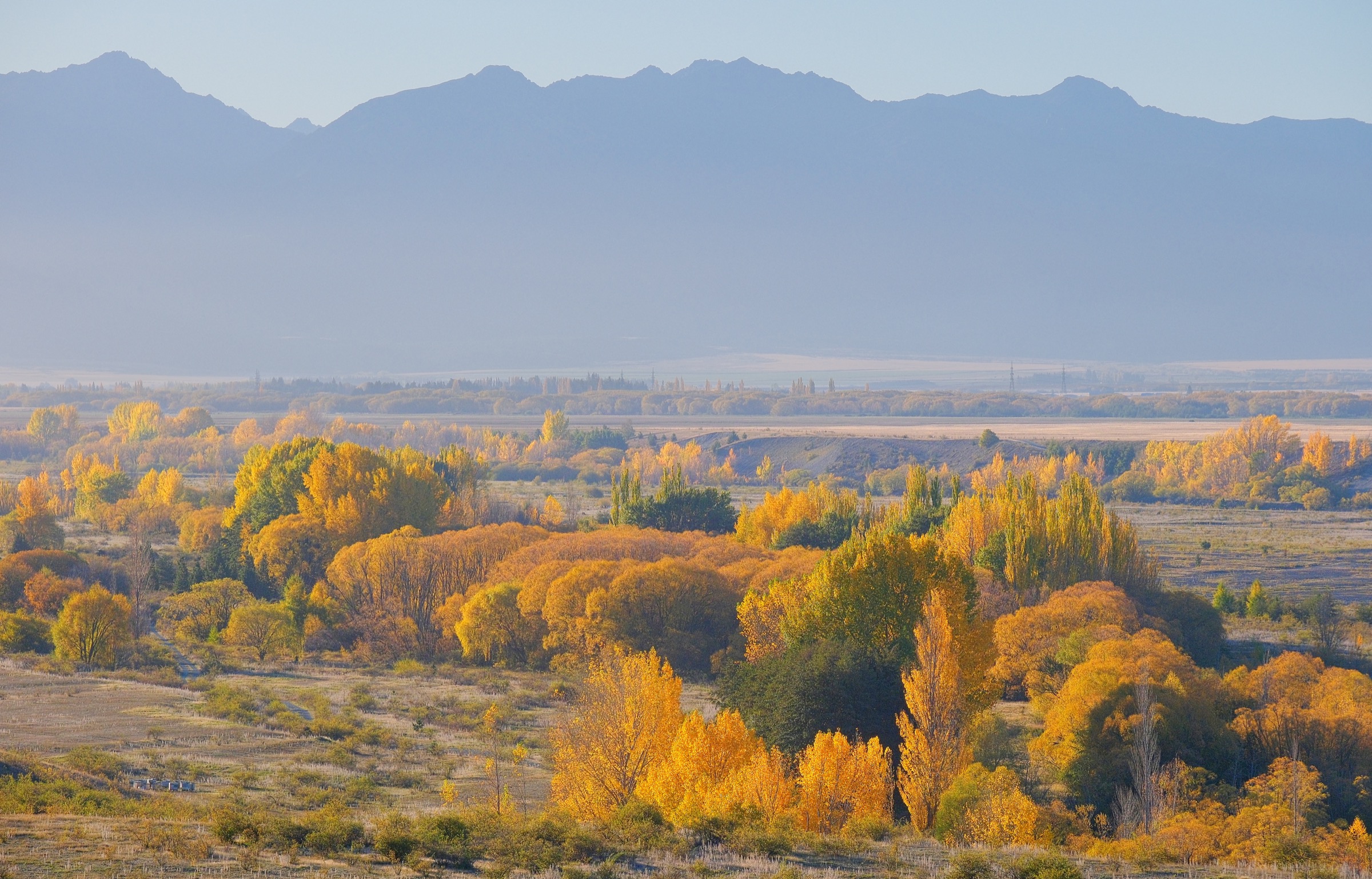
The Lake Ōhau sector sits at the southern hinge of the Ben Ohau Range, where the steep eastern wall of the Ben Ohau Range and the rolling western front of the Barrier/Ohau Range close in around a long ribbon glacial lake in the upper Mackenzie Basin. Most of the walking divides into two parallel zones. The east shore is dominated by Ben Ōhau itself (1522 m) and tussock-cloaked foothills; the west shore rises sharply through beech remnant forest, glacial moraine terraces and tarn basins to the Ōhau Snow Fields ridge and Mount Sutton (2007 m). The lake itself sits at roughly 520 m and drains south through the Ōhau River and a chain of hydro-canals into Lake Benmore.
The main hiking centres are Lake Ōhau Village and Lake Ōhau Lodge on the south-west shore (about 20 km west of Twizel via State Highway 8 and Lake Ōhau Road), the Lake Middleton campsite immediately south of the main lake, and the Quailburn historic site at the head of Quailburn Road north of Ōmarama. The Alps 2 Ocean Cycle Trail (A2O) runs across the whole sector, providing the lake-shore Lake Ōhau Track on its eastern flank (Section 3) and the climbing Tarnbrae/Quailburn route to Ōmarama on its western flank (Section 4). The Department of Conservation administers two adjoining parks here: Ruataniwha Conservation Park covers the lake shore and west side, and Ahuriri Conservation Park covers Freehold Creek, Sawyers Creek and Quailburn. Te Araroa, New Zealand’s national long-distance trail, follows the same alignment along the lake and through Freehold Creek.
Terrain is glacially sculpted: lake-shore beech and matagouri remnants, ancient moraine benches, U-shaped side valleys, tussock-tarn basins around 1300–1500 m, and rocky alpine ridges from 1800 m up. The October 2020 Lake Ōhau wildfire burned 5043 ha around the village and along three creeks behind it, including parts of the Lake Ōhau Track and the lower Freehold, Sawyers and Parsons creek catchments. Most tracks have since reopened, but burned beech stands, exposed slopes and ongoing replanting work remain conspicuous along the lower routes.
A geographical caveat applies to one of the hikes selected below: Mount Sutton and the Ōhau Snow Fields are technically on the Barrier/Ohau Range west of Lake Ōhau, not on the Ben Ohau Range proper, which sits on the eastern side. The two ranges bracket the southern Lake Ōhau basin and are routinely walked together from a single road base, but stricter geological treatments separate them.
The reliable snow-free walking season runs mid-November to late April. Lower lake-shore and A2O sections remain accessible most of the year. The Ōhau Snow Fields chair lift normally runs only during the June–October ski season, so any summer ascent of the Sutton ridge is a foot ascent from the road end. Mackenzie Country weather is unstable: hot, dry nor’westers can turn into cold southerlies within hours, and afternoon convective storms are routine in summer. Sun protection, windproof layers and full water carry are essential, as there is little reliable shade above the bushline.
Selection rationale
The five hikes were chosen to span the four landscape types of the southern sector and to keep each route inside day-hike limits — under about 22 km and 1300 m of gain. They are: a lake-shore A2O classic linking Lake Ōhau Village and Lake Middleton with the moraine head of the lake; the Freehold Creek Track to the upper basin tarn, a creek-and-beech-forest route into subalpine country; a summit objective on the Barrier/Ohau Range above the ski field, the ridge to Mount Sutton from the Ōhau Snow Fields road end; the Tarnbrae/Quailburn A2O climb from Lake Ōhau Lodge to the Quailburn historic woolshed; and a shorter beech-forest and viewpoint walk from the Quailburn historic site towards the bushline, with an optional saddle extension. Multi-day routes into the Hopkins, Huxley and Dobson valleys and the long ridge traverse to Dumb-bell Lake have been excluded as overnight tramps. Ben Ōhau (the peak) and the Greta/Glen Lyon side are covered in a separate Ben Ohau Area entry.
Summary
| # | Hike | Country | Route type | Distance | Gain | Max elevation | Difficulty |
|---|---|---|---|---|---|---|---|
| 1 | Lake Ōhau Track (Village to Round Bush) | New Zealand | Point-to-point | ~8 km one way | ~120 m | ~580 m | Easy |
| 2 | Freehold Creek Track to upper basin tarn | New Zealand | Out-and-back | ~13–14 km | ~500–600 m | ~1,480 m | Moderate |
| 3 | Mount Sutton via Ōhau Snow Fields ridge | New Zealand | Out-and-back | ~7–9 km | ~600–700 m | 2,007 m | Hard |
| 4 | A2O Lake Ōhau Lodge to Quailburn Woolshed | New Zealand | Point-to-point | ~19 km | ~380 m | ~900 m | Moderate |
| 5 | Quailburn Track to bushline (with Saddle option) | New Zealand | Out-and-back | 3 / ~8 km | ~120 / ~450 m | ~750 / ~1,100 m | Easy / Moderate |
1. Lake Ōhau Track (Village to Round Bush)

Snapshot
Itinerary
From the southern trailhead at the end of Lake Ōhau Road near the Lake Ōhau Village turn-off, the track drops to the lake foreshore and follows a gravelled benched path north along the lake’s western shore. The first kilometres pass through the burn-zone of the 2020 Lake Ōhau wildfire, where regenerating mānuka, matagouri and tussock are gradually reclaiming the slopes. The trail then traces the moraine-built southern lobe of the lake, climbs gently over low ridges between bays and crosses several small side streams. Views west are dominated by Mount Sutton and the ridge above the Ōhau Snow Fields, with Ben Ōhau filling the eastern horizon. After about 8 km the trail rounds the moraine at the lake’s southern end at Round Bush and reaches the Glen Lyon Road shoulder, where vehicle pick-up is possible. A common turnaround for a shorter day is the Ōhau Weir and footbridge (about 4 km from each end), giving a 14–16 km return option from either side.
Why it is essential
The Lake Ōhau Track is the single best low-effort introduction to the southern Ben Ohau / Barrier Range landscape: a continuous lake-shore line directly opposite the southern Ben Ohau ridge, with classic Mackenzie Basin nor’wester light and direct views of the burn-scarred 2020 fire ground, a major event in recent local history. It is part of both the Alps 2 Ocean Cycle Trail and Te Araroa, so it carries dual national significance, and it is the most accessible walk for visitors staying at Lake Ōhau Lodge or Lake Middleton.
Equipment
- Trail shoes or light boots
- Weatherproof shell
- Sun hat, sunglasses and high-factor sunscreen (no reliable shade)
- 1.5–2 L water; no potable water on the track
- Snacks
- Awareness of mountain-bike traffic on the shared trail
Hazards and notes
- Exposure is low but the trail is largely shadeless and nor’west winds can be very strong.
- The 2020 fire left standing dead beech along several short sections; treefall risk on windy days.
- The trail is shared with cyclists on the A2O; keep right and pass slowly.
- Dogs are not permitted in Ruataniwha Conservation Park.
- No camping along the track itself; nearest camping is Lake Middleton (DOC) and the Round Bush DOC site.
- The Ōhau Weir crossing requires care in high winds.
Routes and maps
| Source | URL |
|---|---|
| DOC — Lake Ōhau Area Tracks | doc.govt.nz |
| Alps 2 Ocean — Section 3 (Twizel to Lake Ōhau Lodge) | alps2ocean.com |
| OpenStreetMap — Alps 2 Ocean Cycle Trail | openstreetmap.org |
| AllTrails — Lake Ohau Track | alltrails.com |
External links
2. Freehold Creek Track to upper basin tarn
Snapshot
Itinerary
The track leaves the Parsons Creek DOC car park on the south side of Lake Ōhau Road, joining the A2O gravel benched track along an ancient glacial moraine. After about 1 km it crosses Sawyers Creek on a wooden bridge. A short signed spur to the right leaves the A2O and continues north-west along an old 4WD route past the Glen Mary Ski Club huts, an alternative trailhead, to a footbridge over Freehold Creek. Beyond the bridge the marked Freehold Creek Track turns upstream on the south bank, climbing gently through mountain beech with native mistletoe up an old bullock-logging trail. The bushline is reached at about 6 km from Parsons Creek; the track then becomes a lightly marked route over tussock, sidling north into the upper Freehold Creek basin and reaching the prominent tarn at 1479 m. Strong parties can continue another 1–1.5 hours to the saddle between points 1922 m and 1817 m for views north towards Dumb-bell Lake and Snowy Gorge, returning by the same route.
Why it is essential
Freehold Creek is the standard alpine taster of the Lake Ōhau area: a single track that climbs from beech forest into tussock-tarn country with views north along the Barrier/Ohau Range and east across the lake to Ben Ōhau. The route is part of Te Araroa and one of only two graded DOC tramping tracks in the immediate Lake Ōhau hinterland. The combination of relict mistletoe-rich beech, mature logging-era trail furniture and a classic moraine-dammed alpine tarn makes it representative of the whole sector.
Equipment
- Sturdy boots
- Trekking poles, useful on the route section above bushline
- Weatherproof and warm layers; basin temperatures can drop quickly
- 2 L water; creek water is generally clean but should be filtered
- Map and GPS; the route above bushline is only lightly marked with cairns
- Headtorch for autumn short days
- Sun protection
- Microspikes worth considering early in the season if snow lingers in the upper basin
Hazards and notes
- The lower forest section is straightforward; above the bushline navigation relies on cairns and natural lines, and visibility drops the track standard significantly in cloud.
- Stream crossings of Sawyers Creek and Freehold Creek can rise quickly after rain.
- The upper basin holds avalanche-prone snow into November.
- Several sections of the lower track pass through 2020 fire damage and rebuilt boardwalks; standing dead trees pose a windfall risk.
- Dogs are not permitted in Ahuriri Conservation Park.
Routes and maps
| Source | URL |
|---|---|
| DOC — Sawyers and Parsons Creek to Freehold Creek Track | doc.govt.nz |
| NZ Tramper — Freehold Creek | tramper.nz |
| Tussock.rocks — Point 1966 via Freehold Creek | tussock.rocks |
| LINZ Topomap — Topo50 base | topomap.co.nz |
External links
- Wilderness Magazine — Freehold Creek, Ohau Conservation Area
- Waitaki NZ — Freehold Creek Track
- DOC — Ahuriri Conservation Park
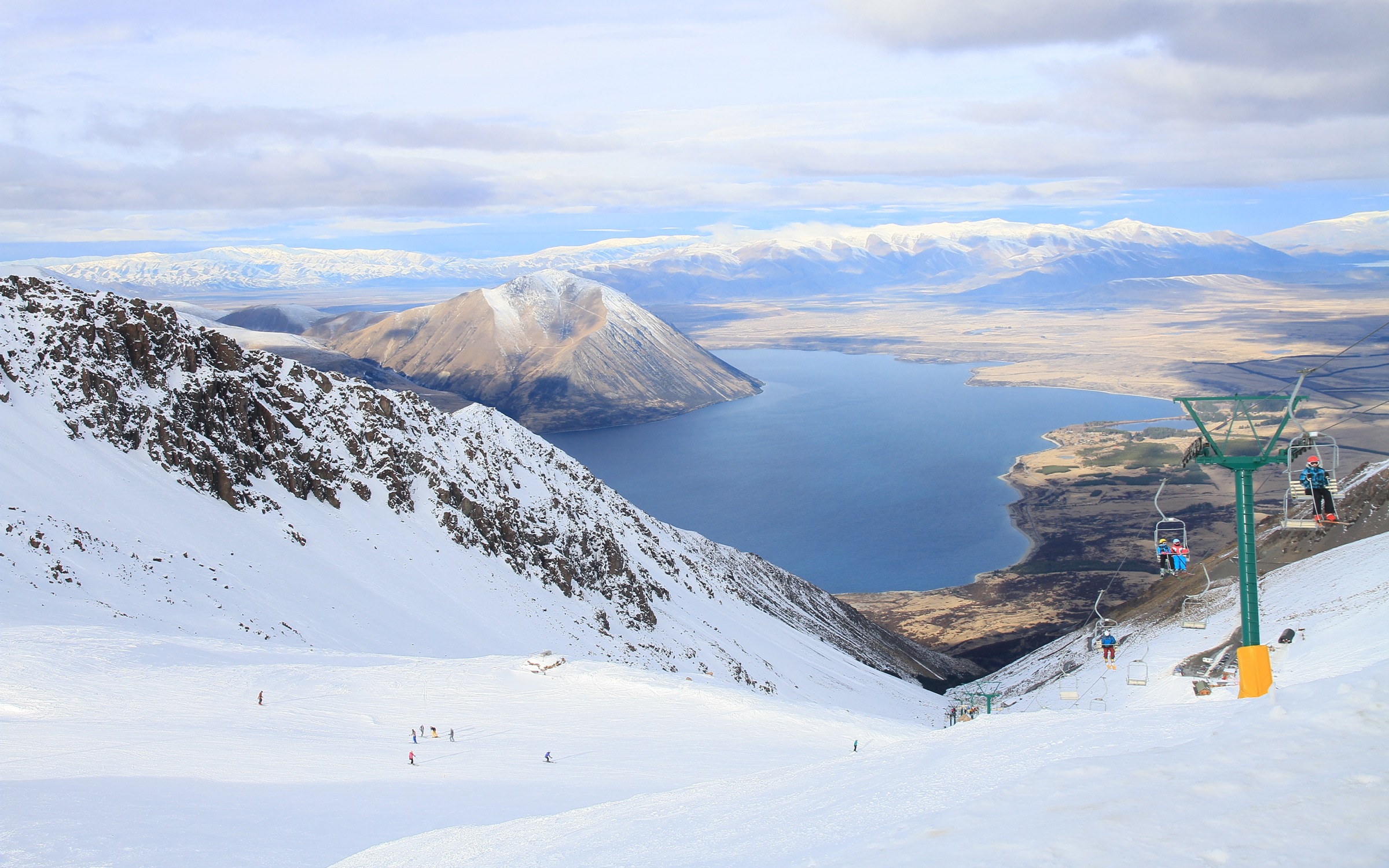
3. Mount Sutton via Ōhau Snow Fields ridge
Snapshot
Itinerary
From the snow fields car park, approximately 1400 m at the base lodge, the ascent in summer begins along the unloaded chairlift line or, more comfortably, along the marked summer access path that contours up the open slopes north-east of the lodge. After about 400 m of climbing on grass and scoria, the ridge above the chairlift top station (about 1825 m) is reached. The route then turns south along the broad, mostly grassed ridge, gaining and losing minor undulations and crossing over point 1918 m. The final approach to Mount Sutton (2007 m) is over the broad, gently sloping northern ridge to the summit cairn, with sweeping views across Lake Ōhau to Ben Ōhau and Aoraki/Mount Cook to the north. Return is by the same line; the more direct ski-touring descent into the basin should not be used by hikers in summer due to loose scree.
Why it is essential
Mount Sutton is the only realistic alpine summit in the Lake Ōhau sub-region that can be combined with a single road approach in a long day. The summit offers the iconic 360-degree view that the lake-shore walks below only hint at, with the Southern Alps to the west, the entire Ben Ohau Range across the lake, and Aoraki/Mount Cook on the northern skyline. Its prominence above the snow fields makes it a recognised local landmark.
Equipment
- Sturdy boots and gaiters
- Trekking poles
- Full waterproof and windproof shell
- Warm hat and gloves regardless of summer date
- 2.5 L water; no water above the lodge
- Map, compass and GPS; the ridge is featureless in cloud
- Sun protection (UV is extreme at elevation)
- Headtorch
- Microspikes and an ice axe worth carrying into early January if snow remnants linger; from May to November the route is a full alpine winter undertaking requiring ice axe and crampons and is outside the scope of this entry
Hazards and notes
- Mount Sutton and the Ōhau Snow Fields are on the Barrier/Ohau Range west of Lake Ōhau, not on the Ben Ohau Range proper; this hike sits within the wider Lake Ōhau hiking sector but is geologically distinct from the Ben Ohau Range itself.
- The ridge is fully exposed to weather; sudden nor’westers and rapid cloud closure are common.
- There is no marked summer route; navigation is the hiker’s responsibility.
- The descent off the chairlift line is loose underfoot and prone to small rockfalls.
- The chairlift cannot be assumed open; check current conditions with the Ōhau Snow Fields office before driving in.
- The ski-field road is unsealed and steep.
- No dogs in the conservation areas above the road.
Routes and maps
| Source | URL |
|---|---|
| ClimbNZ — Mt Sutton | climbnz.org.nz |
| ClimbNZ — Ohau Range | climbnz.org.nz |
| Strava — Mount Sutton community route | strava.com |
| LINZ Topomap — Topo50 base | topomap.co.nz |
External links
- Wilderness Magazine — Easy way up (Mount Sutton)
- Lake Ōhau Lodge — Snow Fields
- Wikipedia — Ōhau (skifield)
4. A2O Lake Ōhau Lodge to Quailburn Woolshed
Snapshot
Itinerary
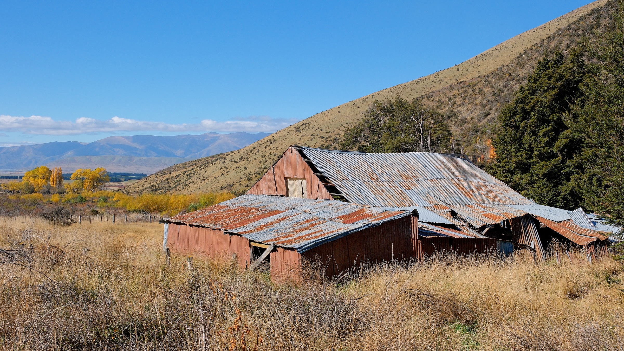
The A2O trail leaves Lake Ōhau Lodge on the lodge driveway and crosses Lake Ōhau Road onto a benched 4WD-grade trail that traverses the lower slopes of the Ohau Range. Easy walking on rolling moraine terraces reaches the Freehold Creek bridge at about 6 km. From here the trail climbs sustained but moderately for 4 km up onto the open Tarnbrae plateau, gaining around 300 m to a high point of about 900 m amongst tussock and scattered tarns. Views east open across the Mackenzie Basin to the Ben Ohau Range and north to the Southern Alps. The trail then descends gently through the bushline and beech belt for the remaining 8 km, dropping onto Quailburn Road just above the historic 1920s Quailburn woolshed — now a derelict landmark, much of it further damaged in October 2020 storms. A small Quailburn campsite and DOC car park sit beside the woolshed and serve as the pick-up point. Walkers normally complete the section in one direction, downhill-trending, from Lake Ōhau Lodge to Quailburn.
Why it is essential
The Tarnbrae crossing is the only realistic day-walk traverse of the southern Ben Ohau / Ohau Range, linking the lake basin to the high Tarnbrae country and to the most important historic pastoral site in the area at Quailburn. It is also the section of the A2O cycle trail most often walked rather than ridden, because of its high tussock-open landscape character. It functions as a landscape summary of the whole sector: lake-shore, beech remnants, moraine bench, alpine tarn plateau and pastoral history.
Equipment
- Trail runners or light boots; the graded surface is forgiving
- Weatherproof shell and warm layer
- Sun hat and sunglasses
- 2 L water; no reliable potable water between Freehold Creek and Quailburn
- High-energy food
- Map and GPS; the trail is well marked but exposed in cloud
- Headtorch; the route is long and shoulder-season days are short
- Awareness of cyclists on the shared trail
Hazards and notes
- Exposure on the Tarnbrae plateau is significant; nor’west and south-west winds can be punishing and there is no shelter for 6–8 km.
- Avalanche-prone slopes cross the high section May–November; DOC closes the high section in winter snow conditions.
- The trail is shared with A2O cyclists, who can move quickly downhill on the Quailburn descent.
- Dogs are not permitted.
- Vehicle access at Quailburn requires the gravel Quailburn Road, which is rough but normally 2WD-passable.
Routes and maps
| Source | URL |
|---|---|
| Alps 2 Ocean — Section 4 (Lake Ōhau Lodge to Ōmarama) | alps2ocean.com |
| DOC — Tarnbrae Track A2O | doc.govt.nz |
| Trailforks — A2O Lake Ohau Lodge to Quailburn Road | trailforks.com |
| OpenStreetMap — Alps 2 Ocean Cycle Trail | openstreetmap.org |
External links
- DOC — Quailburn Historic Site
- Alps 2 Ocean Cycle Trail (official)
- Wikipedia — Alps 2 Ocean Cycle Trail
5. Quailburn Track to bushline (with Saddle option)
Snapshot
Itinerary
The walk starts from the gravel car park beside the 1920s Quailburn woolshed and the remains of the sheep dip, homestead and musterer’s huts, originally part of the extensive Benmore Station from 1866. A signed track leaves the historic area and climbs gently uphill through mountain beech forest, crossing Quailburn Stream several times on small footbridges. After about 1.5 km the track reaches a clearing at the bushline with views back across the Quailburn valley to the Ahuriri Conservation Park ridges. The short walk turns here. For the saddle extension, a rougher unmaintained route — the Quailburn Saddle route — continues uphill on tussock spurs, gaining another 350 m to the Quailburn Saddle at about 1100 m, from where on a clear day the East Ahuriri Hut and the upper Ahuriri valley are visible. Return is by the same route.
Why it is essential
The Quailburn Track is the cultural and historical anchor of the southern sector: the Quailburn woolshed is the most visible surviving high-country pastoral structure in the Lake Ōhau / Ōmarama area and the start of the conservation country to its north. The forest walk and the saddle option are also the shortest entries into the Ohau Range tussock from the south, giving a compact taste of mountain beech, glacial valley and high tussock plateau in a half-day. Combined with the woolshed visit, it carries strong heritage value.
Equipment
- Trail shoes for the short walk; sturdy footwear for the saddle extension
- Sun protection
- Water (1–2 L)
- Weatherproof and warm layers for the saddle extension
- Navigation backup; the route is unmarked above the bushline
- Insect repellent — sandflies can be persistent at the woolshed area in still summer weather
Hazards and notes
- The short section is sheltered and easy; the saddle option crosses unmarked tussock and can be confusing in cloud.
- Quailburn Stream can rise quickly after heavy rain.
- The woolshed itself is fragile and partially collapsed; do not enter the structure.
- The Quailburn historic site is on conservation land but is bordered by pastoral leasehold land, so stick to marked tracks.
- Dogs are not permitted in the conservation park.
- Free overnight camping is available at the adjacent Quailburn campsite, with basic facilities.
Routes and maps
| Source | URL |
|---|---|
| DOC — Quailburn Track | doc.govt.nz |
| DOC — Quailburn Historic Site | doc.govt.nz |
| Waitaki NZ — Quailburn Track | waitakinz.com |
| LINZ Topomap — Topo50 base | topomap.co.nz |
External links
- DOC — Ahuriri Conservation Park
- Herenga ā Nuku Aotearoa — Walking Access Mapping System
- Wikipedia — Ben Ohau Range