Regional overview
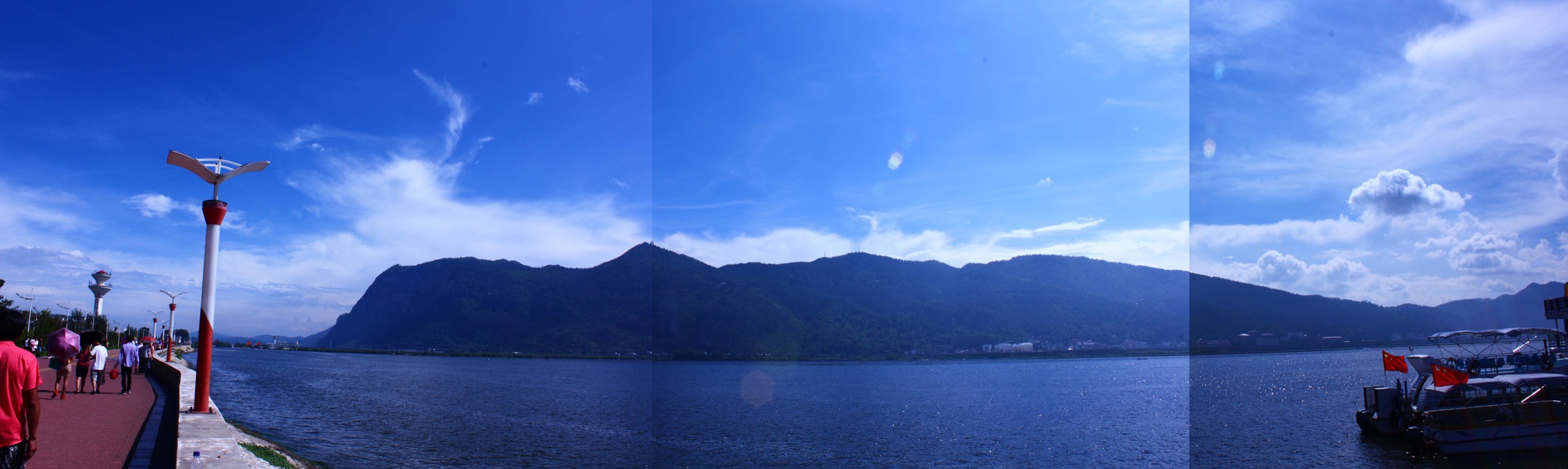
The Kunming basin sits at roughly 1,890 m on the western edge of the Yunnan–Guizhou Plateau (Yungui Gaoyuan 云贵高原), where the plateau is broken into a chain of fault-bounded lacustrine basins draining north toward the Yangtze. The largest basin is occupied by Lake Dian (Dianchi 滇池), a 298 km² shallow tectonic lake whose surface sits at 1,886.5 m. Immediately above the western shore, the limestone-and-sandstone Western Hills (Xishan 西山) rise as a long forested ridge — about 40 km north-south — culminating in Luohan Peak (罗汉山) at 2,507.5 m, some 620 m above the lake. The Western Hills are the signature foreground of the Kunming view and, with the Daoist grotto at Dragon Gate (Longmen 龙门), a chain of Buddhist temple compounds (Huating 华亭, Taihua 太华, Sanqing Ge 三清阁) and the tomb of national-anthem composer Nie Er (聂耳), the city’s defining day-walking ground.
Beyond Xishan the uplands surrounding the basin are dominated by mature Permian-limestone karst on the plateau surface and Devonian dolomite at depth. Three of the surrounding karst landscapes carry international or national designation. The Stone Forest (Shilin 石林), inscribed in 2007 as a serial component of the South China Karst UNESCO World Heritage Site (the Naigu Stone Forest 乃古石林 and Suogeyi 所各邑 nominated zones), is the textbook continental pinnacle-karst landscape and lies 90 km east of Kunming. Jiuxiang (九乡), 90 km east-northeast in Yiliang County, is a national geopark and the largest karst-cave cluster in China, focused on the Maitian River canyon (麦田河) and the multi-storey caverns developed in Sinian–Cambrian Dengying Formation siliceous limestone. Yangzonghai (阳宗海), a 31 km² fault lake at 1,770 m, sits in a deeper north-south valley 45 km east of Kunming and is fringed by limestone ridges rising to 2,400 m on its eastern shore. To the northwest of the city, the basalt-and-sandstone bluffs of Yu’an Mountain (玉案山) carry the Yuan-dynasty bamboo-temple of Qiongzhu Si (筇竹寺), reached on a quiet ridge walk through pine and the temple’s namesake bamboo (Qiongzhuea 筇竹). On the western edge of the Kunming municipality, Anning (安宁) is the site of the 2,000-year-old hot springs at the foot of Yuquan Shan (玉泉山) and the Tanglangchuan canyon (螳螂川) — the upper Pudu River — whose tributary the Qinglong Gorge (青龙峡) cuts a sheer-walled limestone slot 29 km north of Anning town.
Day-hike practicality on the plateau is unusually generous. Kunming’s “Spring City” (Chuncheng 春城) climate gives 12–15 °C daytime temperatures in winter and 20–25 °C in summer with a strong May–October rainy season; the dry season (November to April) gives reliable hiking weather, although February and March bring strong UV at altitude. All five walks below lie inside fee-paying scenic areas with paved or boardwalk surfaces; private off-trail walking on the karst or inside the caves is not permitted. Public transport from Kunming is good — the metro extends to the western shore of Dianchi, dedicated tourist coaches serve the Stone Forest and Jiuxiang from the long-distance bus stations and from Kunming South Railway Station (the high-speed-rail hub), and a dense city-bus network covers Xishan and Qiongzhu Si. Hard-floor cautions: the Dianchi shore (and especially the lake itself) has been a heavily polluted Grade-V water body since the early 2000s — Xishan walks look down onto a lake that is not for swimming — and Yangzonghai has been arsenic-contaminated since 2008 and is similarly unsuitable for water contact. Drone restrictions apply throughout greater Kunming because of the proximity of Changshui International Airport and several military installations. Sibling files in the same Yunnan–Guizhou Plateau batch cover the Dalou Mountains on the Guizhou–Chongqing border and the Wumeng Mountains of central Guizhou and Yunnan; this file is restricted to walks within roughly 100 km of Kunming.
Selection rationale
Five hikes span the four landform families that define the Kunming basin — temple-and-grotto ridge above the lake, UNESCO continental pinnacle karst, multi-storey karst cave-and-canyon, sandstone temple ridge, and limestone river gorge. The Xishan Dragon Gate ridge traverse (Gaoyao to Huating, Taihua, the Nie Er tomb, Sanqing Ge and Longmen) is the signature Kunming walk, a ridge-and-temple traverse with the iconic Dragon Gate grotto and the lake view that defines the city. The Shilin Stone Forest loop covers the Greater and Lesser Stone Forest, the textbook continental pinnacle-karst landscape and the only UNESCO-listed walk on the plateau. The Jiuxiang Diehong Bridge traverse drops to the Maitian River through the largest cave cluster in China and returns by cable car. Qiongzhu Si on Yu’an Mountain gives the quiet ridge-and-temple walk through pine and bamboo to the first Chan Buddhist site in Yunnan. The Anning Qinglong Gorge boardwalk in the upper canyon of the Pudu River is the outlying river-gorge walk that complements the four ridge, temple and karst hikes. The five together cover the lake basin’s defining ridge, two of its most-photographed karst landscapes, its first Chan temple and its best-known canyon, without duplicating any walk in the Dalou Mountains or Wumeng Mountains files.
Summary
| # | Hike | Country | Route type | Distance | Gain | Max elevation | Difficulty |
|---|---|---|---|---|---|---|---|
| 1 | Xishan Dragon Gate ridge traverse (Gaoyao to Longmen) | China | Point-to-point ridge traverse | ~6.6 km one way | ~620 m | ~2,350 m | Moderate |
| 2 | Shilin Stone Forest UNESCO karst loop | China | Loop | ~6–10 km | ~150–200 m | ~1,900 m | Easy–moderate |
| 3 | Jiuxiang Diehong Bridge gorge-and-cave traverse | China | One-way with cable-car return | ~3–4 km | ~150–200 m | ~1,900 m | Easy–moderate |
| 4 | Qiongzhu Si bamboo-temple ridge walk (Yu’an Mountain) | China | Out-and-back | ~5–7 km | ~250–350 m | ~2,150 m | Easy–moderate |
| 5 | Anning Qinglong Gorge limestone-slot walk | China | Out-and-back | ~5 km | ~150–250 m | ~1,950 m | Easy–moderate |
1. Xishan Dragon Gate ridge traverse (Gaoyao to Longmen)
Snapshot
Itinerary
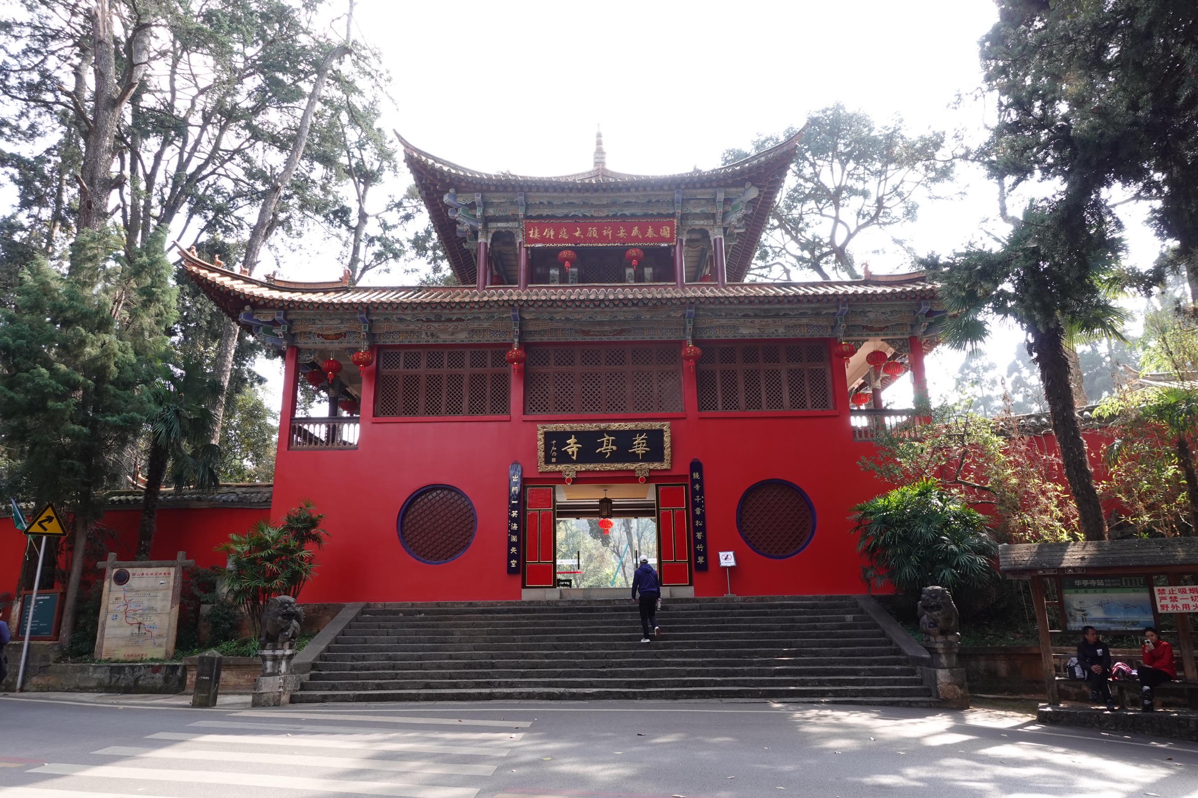
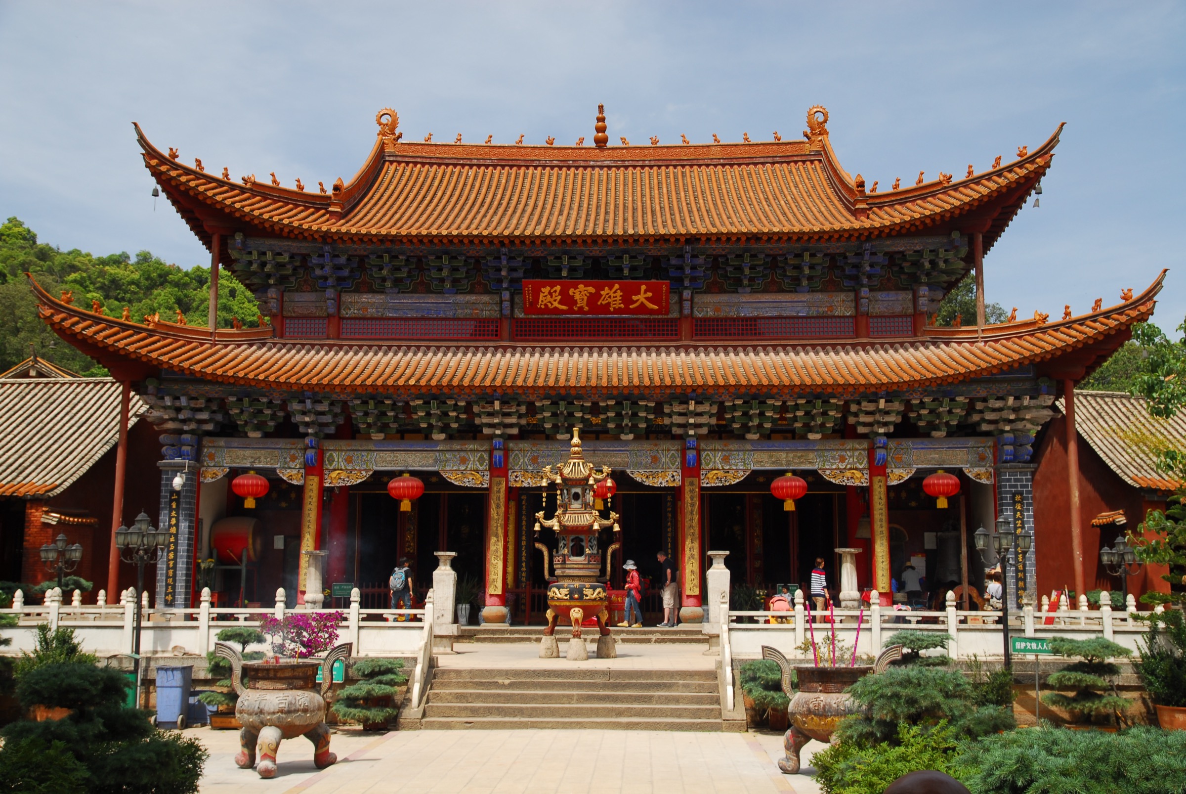
The standard pilgrimage line begins at the Gaoyao bus terminus on the western shore of Lake Dian, walks the paved Xishan road uphill past the park gate, and climbs first to Huating Temple (华亭寺), the oldest Buddhist temple on the ridge — Yuan-dynasty foundation, Qing-period restoration — at roughly 2,050 m. From Huating the road continues south along the ridge for around 2.5 km to Taihua Temple (太华寺), a Yuan-foundation Chan compound on the high shoulder at around 2,200 m. A signed footpath, the Taihua Ancient Passage (太华古道), runs roughly half a kilometre shorter than the road and offers a wooded alternative through a remnant cedar-and-pine forest.
South of Taihua the path passes the tomb of Nie Er (聂耳墓), the Kunming-born composer of the Chinese national anthem, set on a small landscaped knoll with views east over the lake. The route then traces the cliff line south to the Sanqing Ge (三清阁) Daoist complex, built into the limestone cliff face, and reaches the entrance to the Dragon Gate grotto (Longmen 龙门石窟) — a sequence of caves, terraces, a stone archway and the principal carved chamber, all hewn by hand into the same vertical sandstone cliff between 1781 and 1853. A final viewing platform hangs around 2,350 m above sea level and roughly 460 m above the water. The lake fills the foreground; in clear weather the city of Kunming reads across the eastern shore.
From Longmen the standard descent is by the Dragon Gate chair-lift or cable car east to Haigeng, or by the sightseeing bus that links the major stops down to Gaoyao. Walkers preferring a foot descent can take the Thousand-Step Cliff (Qianbuyan Gudao 千步岩古道), a steep stone-stair ancient path of about 3 km that drops from Longmen to the lake-shore Longmen Village bus stop.
Why it is essential
The Xishan ridge traverse is the defining day walk of the Kunming basin and the only walk in this selection that delivers the full lake view from height. The combination of three Yuan-foundation temples (Huating, Taihua, Sanqing), the Nie Er tomb and the Dragon Gate cliff grotto — one of the most ambitious hand-hewn Daoist grottos in southern China — makes it the cultural counterpart to the Stone Forest’s natural-monument status. Among Chinese-language route databases it is the canonical “first hike” of Kunming and is treated as the city’s pilgrimage line.
Equipment
- Trail shoes or light boots (paved road and stone stair; occasional smooth sandstone polished by foot traffic)
- Weatherproof shell (afternoon thunderstorms common May to October)
- Warm mid-layer for the Longmen viewing platform (windy and exposed)
- Sun and UV protection — the ridge is at 2,000–2,350 m and sun strength is high
- 1.5 L water; refills at Huating and Taihua temple shops
- Snacks; full restaurants at Huating and Longmen Village
- Cash for temple entry tickets (Huating and Taihua charge separately from the park entry)
- Trekking pole optional for the Thousand-Step Cliff descent
Hazards and notes
- The Thousand-Step Cliff and the Longmen grotto are narrow and exposed; the grotto tunnel is single-file and only partially railed. Avoid in heavy rain or on icy mornings.
- Cable-car and chair-lift schedules are weather-dependent; high-wind or thunderstorm conditions close the lift. The Thousand-Step Cliff is the backup.
- Lake Dianchi is a Grade-V water body. The view is a view only — do not enter the water.
- Drone restrictions apply across Xishan because of the proximity of Changshui Airport and the lake-shore military reserve.
- Dogs are generally not permitted on the cable car or inside temple compounds; the road sections are more permissive.
- Park, temple and cable-car tickets are sold separately; combined-ticket pricing changes seasonally — verify at the gate.
Routes and maps
| Source | URL |
|---|---|
| OpenStreetMap — Xishan Forest Park (西山森林公园 / 龙门 / 华亭寺) | openstreetmap.org |
| AllTrails — Xishan West Hill – Longmen Temple | alltrails.com |
| AllTrails — Xishan Forest Park Loop | alltrails.com |
| Pacer — Xishan walking map | mypacer.com |
External links
- Wikipedia — Xishan Forest Park
- Wikipedia — Dianchi Lake
- GoKunming — Getting Away: Xishan
- China Discovery — Western Hills, Kunming Xishan, Kunming Dragon Gate
- Travel China Guide — Western Hills, Xishan Forest Park, Kunming: Dragon Gate
2. Shilin Stone Forest UNESCO karst loop
Snapshot
Itinerary
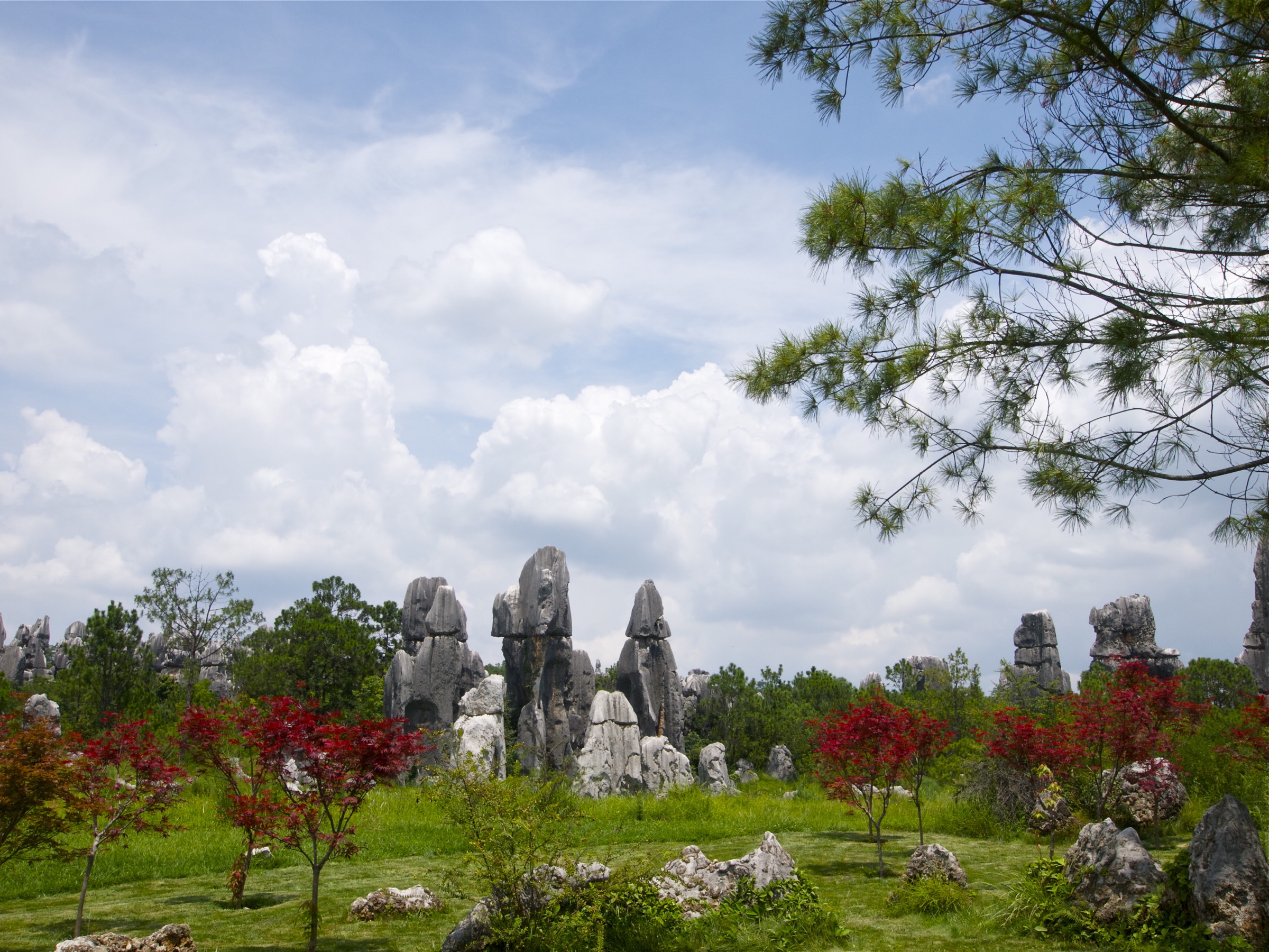
From the inscribed plaza at the main entrance the canonical route enters the Greater Stone Forest (Dashilin 大石林) anti-clockwise. The published park itinerary names the principal waypoints in sequence: Stone Forest Lake (石林湖), Lion Pavilion (狮子亭), Green Ox Sporting in Water (青牛戏水), Stone Folding Screen (石屏风), the Zhu De Inscription (朱德题词), Crocodile Stone (鳄鱼石), Stone Forest Vista (石林胜景), A Hair’s Breadth (千钧一发), Mountain of Knives and Sea of Fire (刀山火海), Just-Right Resting Stone (且住为佳), Lotus Peak (莲花峰), and Sword Peak Pond (剑峰池) — the small enclosed lake ringed by upright limestone blades that is the most photographed single composition in the park. The route then continues via Punching and Kicking Stone (拳打脚踢), Extreme Narrow Passage (极狭通人), Looking-Up-and-Down (仰天俯地), Thousand-Year Old Vine (千年古藤), Twin Birds Feeding (双鸟渡食), Rhino Looking at the Moon (犀牛望月) and Elephant Pavilion (象踞石台) to Wangfeng Pavilion (望峰亭) on the highest point of the Greater Stone Forest, which gives the only true overhead view of the pinnacle field.
From Wangfeng the route descends through Heart Stone (心脏石), Tiao Yue Ping (跳月坪) and Tang Monk Stone (唐僧石) toward the Lesser Stone Forest (Xiaoshilin 小石林), a more open, more gently spaced karst pavement that contains the Ashima Stone (阿诗玛石) — the personified pillar of the Yi heroine that gives the park its cultural emblem. A level path returns to the inscribed plaza.
The Greater Stone Forest occupies the densest and tallest pinnacle field — single pillars exceed 30 m above the path — and concentrates the most-named formations; the Lesser Stone Forest is the quieter, more spacious cousin and hosts most of the Yi traditional song-and-dance performances. Both sit on a Permian limestone surface in which roughly 270 million years of dissolution has produced the sharpest expression of continental pinnacle (or “shilin”) karst documented anywhere in the world. The Naigu Stone Forest (乃古石林) 8 km north and the Suogeyi (所各邑) zone are the two areas formally inscribed as serial components of the South China Karst UNESCO World Heritage Site (2007).
Why it is essential
The Stone Forest is the only UNESCO World Heritage walk in the Kunming basin and the textbook continental-karst pinnacle landscape — the named type locality for the shilin karst pattern in international geomorphology. As the most internationally famous single landform in Yunnan after Lijiang’s Jade Dragon Snow Mountain (Yulong Xueshan 玉龙雪山), and as the only walk in this selection that crosses the inscribed boundary of the UNESCO South China Karst, it is the essential karst pick for the catalogue.
Equipment
- Walking shoes or trail shoes (paths are paved but include narrow stepped passages between pillars)
- Sun protection — the karst pavement reflects light strongly and shade is limited in the central pinnacle field
- Hat and sunglasses
- 1 L water; refill at the visitor centre
- Light shell layer for short afternoon rain showers May to October
- Cash for the park entry ticket (around 130 RMB high-season for the Greater + Lesser combined zone, subject to change)
- Trekking pole optional and largely unnecessary
Hazards and notes
- The narrow stepped passages between pinnacles (for example Extreme Narrow Passage 极狭通人) have a real fall hazard on either side; supervise children and large packs.
- Crowds at peak times (Torch Festival, October national-day week, Chinese New Year) significantly slow the central pinnacle section; early-morning entry is the standard advice.
- The Wangfeng Pavilion is fully exposed; descend before storms.
- Drone use inside the scenic area is restricted; verify on park signage.
- Park tickets and internal sightseeing-bus passes are sold separately; the canonical loop is walkable without the internal bus.
- The Naigu Stone Forest is a separately ticketed sub-zone 8 km north and is not on the canonical loop; treat as a half-day extension.
Routes and maps
| Source | URL |
|---|---|
| OpenStreetMap — Shilin Stone Forest (石林) | openstreetmap.org |
| AllTrails — Shilin Stone Forest | alltrails.com |
| Shilin tourism portal | chinastoneforest.com |
External links
- UNESCO World Heritage Centre — South China Karst
- Wikipedia — Stone Forest
- Wikipedia — Shilin County
- China Discovery — Kunming Stone Forest
- Asia Odyssey — Kunming Stone Forest
3. Jiuxiang Diehong Bridge gorge-and-cave traverse
Snapshot
Itinerary
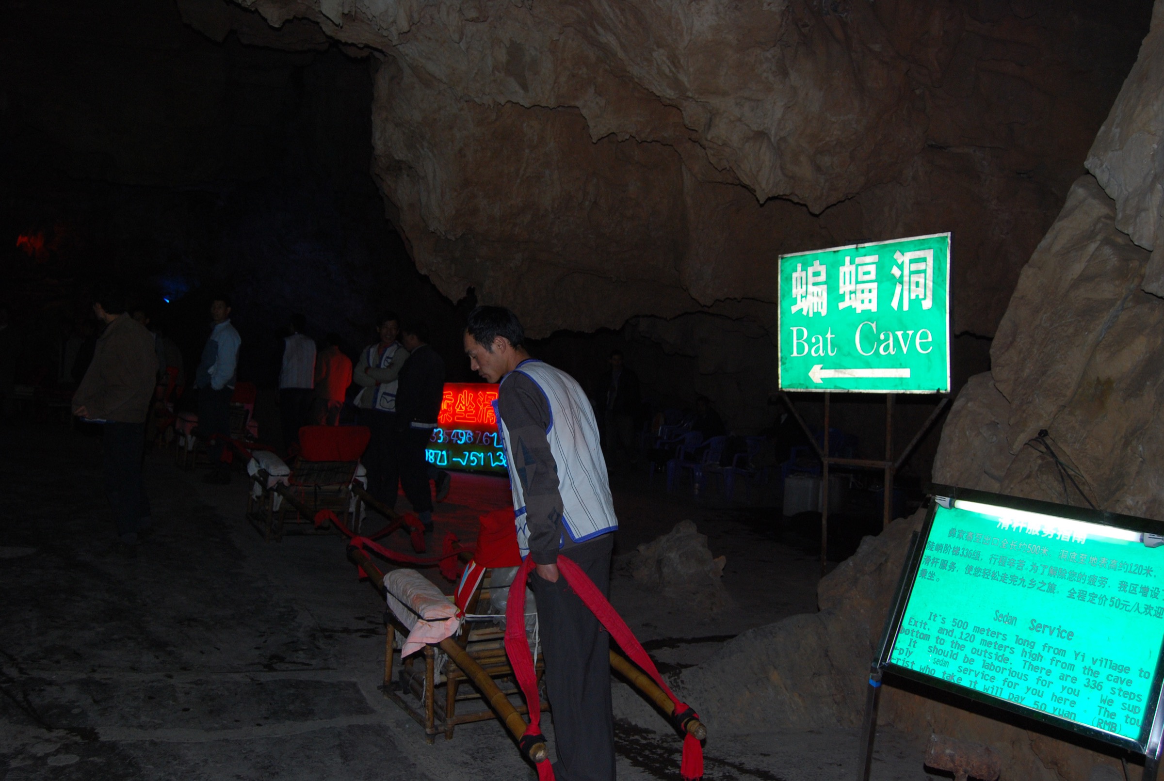
The Diehong Bridge (叠虹桥) circuit is the only sub-zone of the Jiuxiang scenic area currently open to general visitors. The route begins at the main entrance and immediately drops on a sightseeing lift (观光电梯) of about 50 m into the upper canyon. From the lift base the boardwalk enters the Yincui Gorge (荫翠峡), a 1 km river-level boardwalk-and-boat section between near-vertical green-clad limestone walls — the standard published photograph of the site — where small punted boats run a short cruise along the deepest enclosed water.
The route leaves the boat segment and enters the cave system at the Jinghun Gorge (“Soul-Startling Gorge” 惊魂峡), an underground river canyon roughly 700 m long and 100 m deep, described in Chinese-language sources as the most magnificent underground canyon in China. The next chamber is the Xiongshi Dating (Grand Lion Hall 雄狮大厅), the largest single cave chamber in the system, followed by the Shennü Gong (Goddess Cave 神女宫), the most heavily decorated dripstone gallery in the developed section, and the Cixiong Shuang Pu (Twin Male-and-Female Waterfalls 雌雄双瀑) — two parallel 30-metre-high waterfalls plunging inside the Wolong Cave (卧龙洞), the signature single composition of the cave system.
Beyond the waterfalls the route emerges into the Shentian (Fairy Fields 神田), a series of stepped rimstone-pool terraces that rise from the cave floor and resemble miniature rice paddies. A short downstream stretch then reaches the Underground Stone Forest (Dixia Daoshilin 地下倒石林), a chamber whose ceiling is hung with hundreds of inverted stalactites that visually echo the surface karst of Shilin. From here the boardwalk re-ascends and the route ends at the cable-car station, which carries visitors back to the rim near the main entrance.
The caves are developed in the siliceous limestone of the Sinian–Cambrian Dengying Formation; the multi-storey cavern structure reflects intermittent Quaternary uplift of the plateau. More than 100 caves have been identified across the broader scenic area and about 60 have been explored. The site has been a national scenic spot since 1994 and a national geopark since 2009.
Why it is essential
Jiuxiang is the only karst-cavern walk on the Yunnan–Guizhou Plateau that combines a deep open river canyon (Yincui), a major underground canyon (Jinghun), the largest single hall in the system (Xiongshi), the distinctive twin-waterfall composition (Cixiong) and a stepped rimstone-pool terrace (Shentian) in a single ~3 km traverse. Among the regional karst landscapes it is the indoor counterpart to Shilin’s outdoor pinnacle field — both inscribed in international and national karst literature, both reached from Kunming as a day trip — and the only walk in this selection that goes under the surface of the plateau.
Equipment
- Trail shoes or grippy walking shoes with closed toes — the boardwalk inside the caves stays slick where dripstone water lands on the timber
- Light warm layer for the cave interior (constant 16–18 °C, cool against river damp)
- Light rain shell — splash from the Twin Waterfalls landing on the cave-mouth boardwalk
- Headtorch optional; the cave is lit but lit dimly
- Water and snacks (kiosks at the entrance; very limited inside the cave)
- Cash for entry (around 60 RMB published, plus around 30 RMB for the cable car return; verify at the gate)
- No drone use inside the scenic area or above the gorge
Hazards and notes
- The cave stair count is high; descending sections of the underground canyon include long timber-step flights with limited handrails and no alternative.
- Boardwalk timber is consistently damp inside the cave; expect a slick surface.
- The route is one-way; once committed past the Goddess Cave there is no walking exit other than continuing to the cable car.
- Cave temperature is constant at around 16–18 °C; surface temperature outside can exceed 25 °C in summer — pack a light shell for the transition.
- Closure of one or more sections for repair after spring snowmelt or summer flood is possible; verify at the gate.
- Dogs are not permitted in the cave system.
Routes and maps
| Source | URL |
|---|---|
| OpenStreetMap — Jiuxiang (九乡) | openstreetmap.org |
| Trip.com — Jiuxiang Scenic Area | trip.com |
External links
- Wikipedia — Jiuxiang Scenic Region
- Travel China Guide — Jiuxiang Scenic Area
- China Highlights — Jiuxiang Caves, Kunming
- China Discovery — Jiuxiang Cave
4. Qiongzhu Si bamboo-temple ridge walk (Yu’an Mountain)
Snapshot
Itinerary
The Bamboo Temple, founded in the late Yuan dynasty (formal building 1280; predecessor structures recorded back to the seventh century), is the first Chan Buddhist temple in Yunnan and sits roughly halfway up the eastern flank of Yu’an Mountain at around 2,150 m. The standard approach from central Kunming is by the C61 bus to the temple gate; the day-walking version of the route descends from the bus to the Yu’an Mountain access-road foot at around 1,900 m and walks the paved road back up under cedar and pine.
The road climbs steadily for about 2.5 km through mixed Yunnan-pine (Pinus yunnanensis) and cedar to the Qiongzhu Si entrance gate, then continues on a stepped path through the temple compound. Inside, the route loops past the three principal halls — the Tianwang Dian (天王殿), the Daxiong Bao Dian (大雄宝殿) and the Huayan Mige (华严阁) — that house the temple’s defining feature: 500 painted clay arhat sculptures by the Sichuan sculptor Li Guangxiu (黎广修), produced from 1883 to 1890 under the Guangxu Emperor and known for their unusually free, almost caricature-style faces and dynamic postures, distinct from the more formal arhat conventions found elsewhere in China.
From the temple a path continues up the ridge through bamboo (Qiongzhuea 筇竹, the namesake) and through the Suburban Park (Kunming Shi Jiaoye Gongyuan 昆明市郊野公园) — a 162-hectare forest park on the same ridge with 85% canopy cover and an average elevation of 2,160 m — and reaches the Xihua Cave (西华洞), a small karst cave on the ridge crest with a panoramic platform over central Kunming and the northern end of Lake Dian. The return is by the same path, or by descending to the road and catching the bus.
Why it is essential
Qiongzhu Si is the cultural pair to Xishan: Xishan is the city’s panoramic ridge, Yu’an Mountain the city’s first Chan temple ridge. The walk is the most accessible “temple in the forest” day hike on the Kunming side of the Western Hills, and the only walk in this selection that links a major Yuan-foundation Chan compound with a continuation to a ridge-crest cave viewpoint and a designated suburban forest park. The bamboo and pine cover give the only deep-shade walk in the selection. The temple is a Major Historical and Cultural Site Protected at the National Level (designated 2001).
Equipment
- Walking shoes or trail shoes (paved road and stepped temple ramps)
- Light shell layer
- Sun protection — the ridge top above the temple is partially exposed
- Water (refill at the temple shop)
- Cash for the temple entry ticket (around 8 RMB — verify on site)
- Modest dress for inside the active temple halls
Hazards and notes
- The temple is an active monastic compound; respect silent zones and photography restrictions in the arhat halls (interior photography is often discouraged).
- Pine-needle litter on the road can become slick in wet weather.
- The Xihua Cave continuation is on a less-maintained ridge path; verify on-site signage before extending.
- The Suburban Park is a free-access urban-edge park with informal trail forks; carry a map.
- Drone use is restricted across the Kunming municipality.
- Dogs are not permitted inside the temple compound; the road and park sections are more permissive.
Routes and maps
| Source | URL |
|---|---|
| OpenStreetMap — Qiongzhu Si / Yu’an Shan / Suburban Park | openstreetmap.org |
| 2bulu — community track (再上筇竹寺) | 2bulu.com |
External links
- Wikipedia — Qiongzhu Temple
- GoKunming — Kunming’s Bamboo Temple
- Top China Travel — Qiongzhu Temple
- Travel China Guide — Bamboo Temple, Kunming
5. Anning Qinglong Gorge limestone-slot walk (upper Tanglangchuan)
Snapshot
Itinerary
The Tanglangchuan (螳螂川) is the upper course of the Pudu River (普渡河), draining north from Lake Dian toward the Jinsha River; the river is “Tanglangchuan” from Haikou (the Lake Dian outlet at the southwest corner of the lake) downstream to Fumin, and “Pudu He” below Fumin. The Qinglong Gorge sits on a tributary about 29 km north of central Anning, where the river cuts a roughly 5 km limestone slot. The scenic area (a national AAAA designation) is centred on the gorge and is the principal canyon walk in the immediate Kunming region.
From the gate the boardwalk drops to the canyon floor and follows the stream upstream between near-vertical limestone walls. Side spurs reach a series of cliff-top platforms with views down into the slot; the principal engineered feature is a 248 m glass-floor suspension bridge — the first glass bridge in Yunnan — hung roughly 108 m above the canyon floor at the upper end of the developed section. The site also offers a 388 m dry slide and a 138 m water slide as alpine-slide return options, both unrelated to the walk itself. Beyond the glass bridge the upper canyon narrows and the boardwalk loops back; the return is on the same path.
Surrounding the gorge are the lower Tanglangchuan banks — the “Golden Tanglangchuan” zone (黄金螳螂川) — which in early spring carries large-scale rapeseed-flower bloom that has become a regional tourism brand. About 15 km south of the gorge are the Anning hot springs (安宁温泉) at the foot of Yuquan Shan (玉泉山, ~1,795 m), discovered in the Eastern Han (~AD 41–44) and the historical anchor of the area; a separate short summit walk on Phoenix Mountain (Fengshan 凤山) above the hot-spring resort gives a 30–40 minute climb to a panoramic platform over the Anning valley toward Kunming.
Why it is essential
The Qinglong Gorge is the only sheer-walled limestone river canyon walk in the immediate Kunming area and the principal outdoor counterpart to Jiuxiang’s underground canyon. As an outlying option that pairs with the Anning hot-spring soak — China’s first documented hot spring, in continuous use for around 2,000 years — and with the Golden Tanglangchuan landscape downstream, it gives the Kunming basin a true river-gorge walk that is not duplicated elsewhere in the selection.
Equipment
- Trail shoes or grippy walking shoes (boardwalk timber and concrete stair, slick when wet)
- Light shell layer
- Sun protection on the canyon-rim platforms
- Water and snacks
- Cash for the scenic-area entry (verify on site); the glass bridge has a separate ticket
- The glass-floor bridge is optional; the canyon walk does not require it
Hazards and notes
- Boardwalk surfaces can be slick after rain; the limestone is polished where heavily walked.
- The glass-floor bridge is optional and ticketed separately. Visitors with a fear of heights can avoid it without leaving the main walk.
- The dry slide and water slide are recreational features, not walking infrastructure.
- The lower Tanglangchuan has had water-quality issues historically; do not enter the river.
- Drone use is restricted across Anning.
- Dogs are generally not permitted on the scenic-area boardwalks.
- The Anning hot-spring resort (Wenquan Town) and the Caoxi Temple (曹溪寺) historical complex are practical post-walk add-ons but are not part of the gorge walk itself.
Routes and maps
| Source | URL |
|---|---|
| OpenStreetMap — Qinglong Xia, Anning (青龙峡) | openstreetmap.org |
| Ctrip — Qinglong Gorge attraction page | ctrip.com |
External links
- Trip.com — The Golden Tanglang River Scenic Zone, Anning
- TripAdvisor — Kunming Qinglong Canyon
- GoKunming — Qinglong Gorge Scenic Area
- Yunnan Exploration — Anning Hot Spring in Kunming
External links
| Source | URL |
|---|---|
| UNESCO World Heritage Centre — South China Karst | whc.unesco.org |
| Shilin tourism portal | chinastoneforest.com |
| Kunming municipal tourism portal | kunming.cn |
| Kunming Yangzonghai Scenic Area Management Committee | yzh.km.gov.cn |
| Wikipedia — Xishan Forest Park | en.wikipedia.org |
| Wikipedia — Dianchi Lake | en.wikipedia.org |
| Wikipedia — Stone Forest | en.wikipedia.org |
| Wikipedia — Jiuxiang Scenic Region | en.wikipedia.org |
| Wikipedia — Qiongzhu Temple | en.wikipedia.org |
| Wikimedia Commons — Category:Shilin (Stone Forest) | commons.wikimedia.org |
| Wikimedia Commons — Category:Jiuxiang Scenic Region | commons.wikimedia.org |
| Wikimedia Commons — Category:Qiongzhu Temple | commons.wikimedia.org |
| OpenStreetMap (ODbL 1.0) | openstreetmap.org |