Regional overview
The Miao Ridge (苗岭 Miáolǐng) runs broadly east–west across the southern half of Guizhou Province and forms the principal hydrological divide between the Chang Jiang (长江, Yangtze) drainage to the north and the Zhu Jiang (珠江, Pearl) drainage to the south. The range takes its name from the dense Miao (Hmong) population on its southern slopes and is treated by Chinese physical geography as one of the four major ranges of Guizhou alongside the Wumeng (乌蒙) to the west, the Dalou (大娄) to the north and the Wuling (武陵) to the northeast. Where the Wuling is older Neogene uplift, the Miaoling rose in the Early Pleistocene as a block faulted out of the central Yunnan–Guizhou Plateau. Its high point, Leigong Shan (雷公山, “Thunder Lord Mountain”), reaches 2,178.8 m on the south flank above Leishan County and is the highest summit in the entire southeastern quarter of the province.
Two contrasting bedrocks dominate the central Miaoling and govern almost everything a walker meets in the field. To the east, around Leigong Shan, Kaili (凯里) and Leishan (雷山), are the Precambrian metamorphic schists and quartzites of the Jianghua block — non-soluble, well-vegetated, drained by clear streams and clothed in the largest single area of subtropical evergreen broadleaf forest in southwest China. Leigong Shan National Nature Reserve protects this forest with 88 per cent canopy cover and is the type-locality of the Chinese dove tree (Davidia involucrata / 珙桐) and the Guizhou golden camellia (Camellia luteoflora / 贵州金花茶). To the west and south, the bedrock changes abruptly to dolomite and limestone karst plateau, inscribed in 2007 (Libo Karst) and extended in 2014 (Shibing Karst) as UNESCO World Heritage under the serial property “South China Karst”. Shibing’s Yuntai Shan (云台山) and Libo’s Maolan (茂兰) are core components of that inscription. Between the two bedrock zones the Wuyang River (舞阳河) cuts an east-flowing canyon system through the metamorphic–karst contact at Zhenyuan (镇远), producing the most dramatic single river gorge of the central range.
Cultural geography is inseparable from the physical setting. The southern slopes of Leigong Shan hold the densest Miao settlement in China — Leishan, Taijiang, Jianhe and Congjiang counties are jointly listed on UNESCO’s tentative list as “Miao Nationality Villages in Southeast Guizhou Province” — with Xijiang Qianhu Miaozhai (西江千户苗寨), the “thousand-household” village of more than 1,400 households, on the north flank, and Langde (郎德), Datang (达塘) and Paika (排卡) in the surrounding valleys. The lower karst belt around Libo is shared between Buyi (Bouyei), Shui, Yao and Miao communities. Old salt-and-tribute roads cross the range north–south, and the historic riverine town of Zhenyuan was a Ming–Qing military prefecture controlling the Wuyang gateway into the southwest. Hiking in the region is therefore unusually entangled with ethnic-village access: a Leigong Shan summit-road walk or a Xijiang ridge connector doubles as a visit to a living Miao cultural landscape.
Operating reality for day-walkers is shaped by climate and protected-area management. The subtropical-monsoonal weather gives the central Miaoling roughly 300 foggy days a year on Leigong Shan, a mean annual summit temperature around 9 °C, and very high humidity from May to September with frequent afternoon thunderstorms; the best walking months are widely reported as March to May and September to November. All five hikes selected here sit inside fee-paying scenic areas with gated access, compulsory sightseeing-bus circulation on the upper sections, and standard scenic-area rules — no off-track walking, no drone flight without permission, no overnight bivouac. Trail signage is generally in Chinese only, and on the longer routes a local guide is normal practice; published GPX downloads from official sources are not common, and OpenStreetMap coverage of the inner scenic-area paths is partial. Fanjingshan (梵净山), although the highest peak in this eastern slice of Guizhou, lies within the Wuling Range rather than the Miaoling and is excluded from this selection.
Selection rationale
Five day-walks were chosen to span the four signature landscapes of the central Miaoling and the cultural landscape that sits on top of them, while staying inside the central-Guizhou box. Leigong Shan summit walk (Xiangshui–Lianhuaping–Jinding) is the high point of the entire Miaoling, the Miao sacred peak and the only true mountain summit in the selection. Shibing Yuntai Shan classic loop (Yingtao Wan–Wuzhi Feng–Yindouge) is the headline UNESCO-listed dolomite-karst walk of central Guizhou, with cliff-plank boardwalks, the Five-Finger Peak viewpoint and the Yindou Pavilion summit area. The Maolan Qinglong stream and Stone-on-Stone Forest day route is the canonical primary-karst-forest walk inside the world’s largest contiguous karst-forest reserve. The Xijiang ridge-and-village walk (Paika and Langde Bala-River connector) is the cultural-landscape route, linking Miao stilt-house villages on the north flank of Leigong Shan via traditional paths above the Bala River and rice terraces. The Zhenyuan Shiping Shan ancient-town ridge (Sifangjing–Fucheng wall–summit pavilion) climbs from the Ming–Qing town directly to the Fucheng wall and the panoramic platform some 200 m above the S-bend of the Wuyang River, the most striking river-gorge view in the central Miaoling.
Together the five cover one Miao sacred summit, one UNESCO dolomite karst, one UNESCO karst forest, one ethnic-cultural village traverse and one historic-river canyon viewpoint, spread across four administrative areas (Leishan, Shibing, Libo and Zhenyuan counties) so that no two routes use the same trailhead. The Funnel Forest (Loudou Senlin) traverse inside Maolan and the Xijiang–Leigongping–Fangxiang traverse were considered but excluded — both are properly two-day commitments rather than essential day-hikes. Fanjingshan is intentionally outside the geographic scope.
Summary
| # | Hike | Country | Route type | Distance | Gain | Max elevation | Difficulty |
|---|---|---|---|---|---|---|---|
| 1 | Leigong Shan summit walk | China | Out-and-back | ~8–10 km | ~600 m | 2,178.8 m | Moderate |
| 2 | Shibing Yuntai Shan classic loop | China | Loop | ~6.8 km | ~500–600 m | ~1,066 m | Moderate |
| 3 | Maolan Qinglong stream + Stone-on-Stone Forest | China | Loop + spur | ~6–8 km | ~200–300 m | ~750 m | Easy–moderate |
| 4 | Xijiang ridge-and-village walk | China | Point-to-point | ~10–14 km | ~300–500 m | ~1,100 m | Easy–moderate |
| 5 | Zhenyuan Shiping Shan | China | Out-and-back | ~3–4 km | ~200–250 m | 668.1 m | Easy–moderate |
1. Leigong Shan summit walk (Xiangshui – Lianhuaping – Jinding)
Snapshot
Itinerary
Leigong Shan is the highest summit of the Miaoling and the sacred mountain of the Miao people; in Miao folklore the peak is the abode of the Thunder God (Leigong, 雷公), and the long summer thunderstorms that rake the upper ridge are read as the deity’s voice. The main path begins at the half-mountain scenic-area gate on the Leishan–Fangxiang road and climbs through subtropical evergreen broadleaf forest — Chinese dove tree (Davidia involucrata), Guizhou golden camellia (Camellia luteoflora) and over 1,500 other plant species, 43 of them under national protection — to the Lianhuaping (Lotus Pool, 莲花池) bench, then up the final ridge stair to the summit platform at 2,178.8 m.
Three small features on the summit recur in trip reports. A square stone-built well — described in local tradition as “the well that the rain cannot fill and the drought cannot dry” — sits at the platform; the broadcasting and meteorological tower marks the high point; and the platform itself, when fog clears, gives a 360-degree view across the upper Miaoling — south to the Bala River (白水河) headwaters and the Xiangshuiyan waterfall, north toward Xijiang and the Bai River, and east toward the Fangxiang valley. Buddha-light, a circular optical phenomenon projected on cloud surfaces below the observer, is reported from the summit in summer and autumn.
The shortest version of the walk is the summit-road shortcut: vehicles ascend the surfaced summit road to the broadcasting-tower drop-off, leaving roughly 40 minutes of stair-climbing to the platform. The standard published walk is the half-mountain entrance to the summit on foot, gaining about 600 m over 4–5 km and returning the same way. Through-walkers occasionally extend the route by descending the south side past the Xiannütang (仙女塘) and Datang scenic area, on a published Xiannütang–Datang traverse of about 5 km that requires a vehicle pick-up at the Datang end.
Why it is essential
Leigong Shan is the high point of the entire Miaoling, the watershed peak between the Yangtze and Pearl drainages on the eastern half of the Yunnan–Guizhou Plateau, the type locality of the Miao sacred-mountain tradition, and the headline summit of the National Nature Reserve that protects the largest single area of subtropical evergreen broadleaf forest in southwest China. As the only true summit walk in the selection — every other route is a karst plateau, river gorge or village connector — it anchors the regional five.
Equipment
- Sturdy trail shoes or light boots
- Weatherproof shell (frequent fog and afternoon thunderstorms)
- Warm mid-layer year-round; summit averages ~9 °C annually
- Trekking pole useful on the upper stair descent
- Sun protection on clear days
- 2 L water; the half-mountain stalls are not reliable in low season
- Snacks; no food sources above the half-mountain entrance
- Headtorch if combining with a sunrise or Buddha-light visit
- Insect repellent in mid-summer
Hazards and notes
- Summer thunderstorms on the summit can be severe; descend at the first thunder.
- Trail surface is slick after rain and frozen in mid-winter; some sections of the upper stair may be closed for ice.
- Off-path walking inside the National Nature Reserve is not sanctioned; botanical collection is prohibited.
- The scenic-area ticket and shuttle arrangements are subject to change; confirm at the Leishan tourism office or the half-mountain gate.
- The longer south-side Xiannütang–Datang descent is poorly marked in places; a local guide is recommended.
- Drone use inside the reserve is generally restricted.
Routes and maps
| Source | URL |
|---|---|
| Guizhou Provincial Forestry Bureau — 雷公山国家森林公园信息资料 | lyj.guizhou.gov.cn |
| OpenStreetMap — 雷公山 / Leigongshan | openstreetmap.org |
| Trip.com — Leigong Mountain tickets | trip.com |
| PeakVisor — Mount Leigong | peakvisor.com |
External links
- TravelChinaGuide — Leigongshan Nature Reserve
- China Exploration — Mt Leigong
- UNESCO World Heritage Centre — Miao Nationality Villages tentative list
2. Shibing Yuntai Shan classic loop (Yingtao Wan – Wuzhi Feng – Yindouge)
Snapshot
Itinerary
Yuntai Shan is the headline component site of Shibing Karst, inscribed in 2014 as Phase II of UNESCO’s South China Karst world-heritage serial property. The mountain is the type locality of subtropical dolomite fengcong (peak-cluster) karst; unlike the more common limestone karst of Yangshuo and Wulong, Yuntai’s towers developed on relatively insoluble Cambrian dolomite over more than 500 million years, producing the unusual silhouette of slim, near-vertical conical peaks separated by deep, narrow gorges. The scenic area covers roughly 210 km², with a 47 km² core zone; the main summit is Tuanlun Yan at 1,066 m.
The published classic loop is the route that most foreign-language sources reduce to “the Yuntai trail”. Starting from the scenic-area gate at the base of the cliff line, the path climbs through the Yingtao Wan (Cherry Bay, 樱桃湾) staging area, then takes the cliff-plank boardwalk past Paiyunguan (排云关) and Yeniudong (Wild Ox Cave, 野牛洞) to the Pantengdao (Vine-Climbing Way, 盘藤道) — a fixed-rope-and-iron-rung scramble through a narrow vertical chimney that is the most photographed feature of the lower ridge. From here a series of stair platforms reaches the Wuzhi Feng (Five-Finger Peak, 五指峰) viewpoint, the canonical view of Yuntai’s dolomite peak-cluster across an interior gorge.
The loop continues past the Liangfengdong (Cool-Wind Cave, 凉风洞), then climbs to Yindouge (Yindou Pavilion, 印斗阁) at the broad summit shoulder, and to the Pingshan Nao (坪山垴) summit platform with its long view back across the karst landscape. The descent threads past Taipo Shi (Old-Woman Stone, 太婆石) and Toudao Lingguan (头道灵关) to close the loop at the main gate. A longer variant — favoured by full-day walkers — substitutes Daoyunqiao (Cloud-Crossing Bridge, 渡云桥), the Tiesuoqiao iron-chain bridge, Laohu Bei (Tiger-Back, 老虎背), Zhougong Dian and Yingxiandong on the higher ridge; this variant is reported as a five-to-six-hour day and is the route in which the published “1,300 step” stair gain is concentrated. A short alternative for less able walkers runs Yingtao Wan – Laohu Jing – Pingshan Nao – Yindouge to the principal Wuzhi Feng viewpoint and returns the same way.
Why it is essential
Yuntai Shan is the type site of the world’s only large-scale, well-preserved subtropical fengcong karst developed in dolomite, and the only UNESCO World Natural Heritage component of the central Miaoling that is opened to foot-traffic on built infrastructure. The combination of cliff plank-road, fixed-rung Pantengdao scramble, summit dolomite stair and panoramic Wuzhi Feng viewpoint makes the classic loop the headline geological day walk of central Guizhou and a structural counterpoint to the forested Leigong Shan summit walk.
Equipment
- Sturdy trail shoes with good grip (wet boardwalk planks and polished dolomite stair are slick)
- Trekking pole useful on the long stair descents
- Weatherproof shell — Yuntai is repeatedly photographed in cloud and rain
- Warm mid-layer for the summit
- Sun protection on the upper ridge
- Water and snacks; kiosks at the gate and at the Cherry Bay staging area
- Gloves optional for the Pantengdao iron rungs
- Headtorch if returning late in the day
Hazards and notes
- Cliff-plank boardwalks are unfenced or only partly fenced in places; vertigo is possible. The Pantengdao chimney section is exposed.
- The longer Daoyunqiao–Tiesuoqiao variant includes the iron-chain bridge above a vertical drop; not recommended for those with vertigo or for children.
- Ice can persist on the upper stair into early March; check at the gate.
- All access is via the gated scenic area; ticket fees and shuttle arrangements are subject to change.
- Drone flight inside the heritage core zone generally requires permission.
- Standard scenic-area rules apply: no off-path walking, no collection, no overnight bivouac.
Routes and maps
| Source | URL |
|---|---|
| UNESCO World Heritage Centre — South China Karst | whc.unesco.org |
| OpenStreetMap — 云台山 (Shibing) | openstreetmap.org |
| GoWesternChina — Shibing Yuntai Mountain Guide | gowesternchina.com |
| Ctrip — Shibing Yuntai Shan attraction page | gs.ctrip.com |
External links
- UNEP-WCMC World Heritage Datasheet — South China Karst
- China Daily — Guizhou’s Yuntai Mountain
- TripAdvisor — Yuntai Mountain of Guizhou
3. Maolan Qinglong stream and Stone-on-Stone Forest
Snapshot
Itinerary
Maolan is the world’s largest contiguous primary karst forest, a 212.85 km² reserve in the Libo Karst component of UNESCO’s South China Karst inscription (Phase I, 2007). Forest cover exceeds 88 per cent; the inventory records more than 2,000 plant and 400 animal species, including nationally protected pangolin, clouded leopard and South China leopard. The eco-tourism zone covers about 19.15 km² along the access road that links the reserve gate with Wuyan Bridge and the principal walking sites; everything outside this zone is core or buffer and is not open to general visitors.
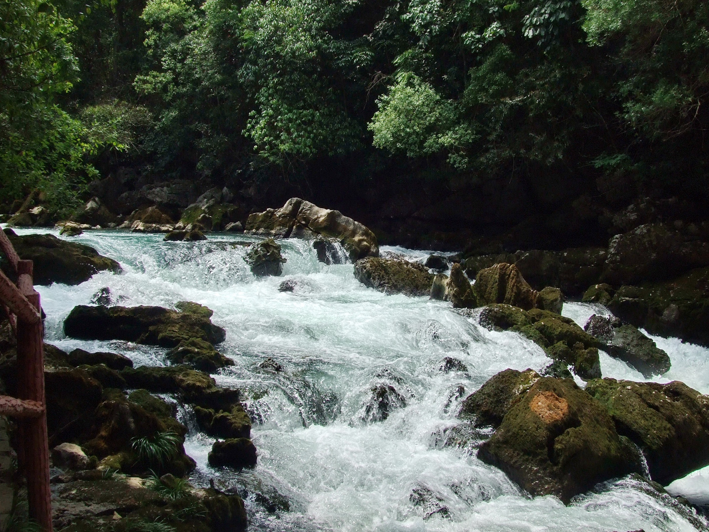
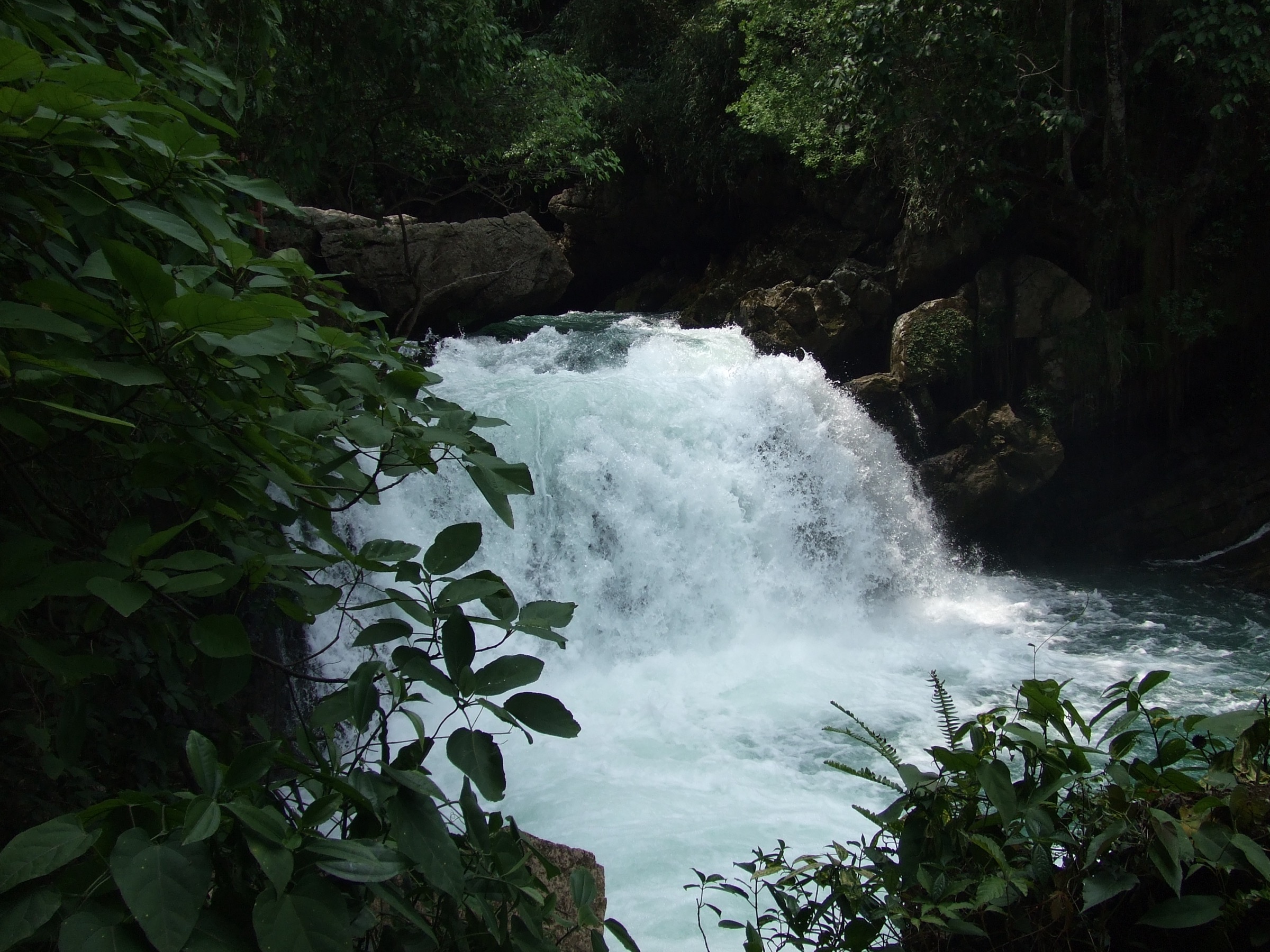
The day-walk version begins at the Wuyan Bridge (五眼桥) area, a Buyi-built stone bridge over a stream that gives the central walking node its name. From here a short surfaced track and stone-flagged path drop to the Qinglong Bridge (Cyan Dragon Bridge, 青龙桥), then follow the stream past the Qinglong Pool (青龙潭) — a karst spring-fed plunge basin with emerald-green water — to the Qinglong Waterfall (青龙瀑布), a tiered drop over polished karst pavement. The path returns by the Qinglong Stream side, with a series of stepping-stone crossings, and rejoins the eco-road at Wuyan Bridge. This loop is the canonical Maolan half-day and runs to roughly 2–4 km on the published route, reported as one to two hours of walking.
The full-day version extends north from the bridge on the eco-road to the Stone-on-Stone Forest (石上森林) stair, then climbs to the observation deck — a wooden platform set on the karst pavement that gives the headline view across the cone-and-tower karst peaks and the unbroken canopy of the primary forest. Walkers with a guide can also extend west along the road to the Crab Valley (Pang Xie Gou, 螃蟹沟) stream-trekking section, where shallow water flows for some 200 m through a slot in the karst pavement under a closed forest canopy; this extension is a wet-foot walk and is shut in high water.
A longer guided traverse — the Funnel Forest (Loudou Senlin, 漏斗森林) day route, published as approximately 10 km from Yanzi Cave through Caogu Forest to Gaowang Exit — exists as a separate full-day commitment, classified as professional-grade, and requires a guide (around CNY 200 per group). It is mentioned for completeness; the Qinglong-and-Stone-on-Stone day captures the same landscape in a manageable form.
Why it is essential
Maolan is the only UNESCO-recognised primary karst forest at this scale in the world (Guinness Records, 2002) and the canonical karst-forest landscape of central Guizhou. The Qinglong loop combined with the Stone-on-Stone Forest deck delivers the four signature Maolan landforms in a single day — stream, plunge pool, karst pavement and forested cone-peak overview — without committing to the harder Funnel Forest traverse. It is also the only walk in the selection that sits inside a UNESCO Man and the Biosphere reserve as well as a World Heritage component.
Equipment
- Trail shoes or light boots (and a second pair of grippy sandals if attempting the Crab Valley wet-foot extension)
- Weatherproof shell — high humidity and frequent rain May–October
- Warm mid-layer; reserve elevation 430–1,078 m, so summer mornings are cool
- Sun protection on the road sections
- Insect repellent and tick protection; the closed forest canopy holds persistent biting flies
- Water and snacks; few reliable supply points inside the reserve
- Local guide strongly advised for any route off the eco-road; mandatory for the Funnel Forest and cave routes
- Headtorch for cave spurs and any late descent
Hazards and notes
- The reserve closes new entries after 17:00; plan ahead.
- Off-path walking is not permitted in the core zone; the eco-tourism area is the only zone open to general visitors.
- The Crab Valley extension is subject to closure in high water; check at the gate.
- Cave-exploration routes (Black Hole, Fairy Cave, Jiudongtian, Golden Lion Cave) require a guide.
- Karst pavement is razor-sharp where exposed; gloves and long trousers reduce abrasion on any scrambling near the Stone-on-Stone deck approach.
- Pit-viper snakes are present in summer; staying on the path is the standard mitigation.
- Drone use inside the reserve is restricted.
Routes and maps
| Source | URL |
|---|---|
| UNESCO Man and the Biosphere — Maolan | unesco.org |
| OpenStreetMap — 茂兰 / Maolan | openstreetmap.org |
| 2bulu community track — Maolan single-person exploration | 2bulu.com |
| Key Biodiversity Areas — Maolan Nature Reserve | keybiodiversityareas.org |
External links
- UNESCO World Heritage Centre — South China Karst
- IntoTravelChina — Maolan Nature Reserve
- TopChinaTravel — Maolan Karst Forest in Libo
- Klook — 2-Day Guizhou Maolan Hiking Tour
4. Xijiang ridge-and-village walk (Paika / Langde Bala-River connector)
Snapshot
Itinerary
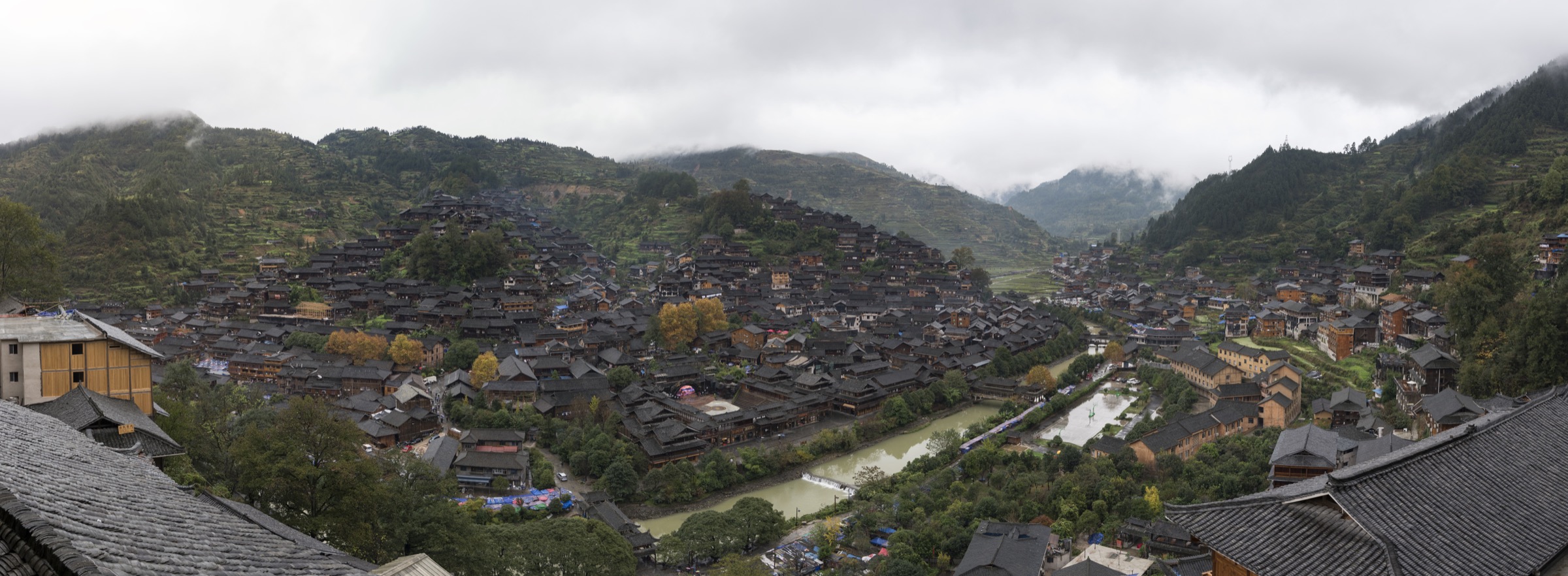
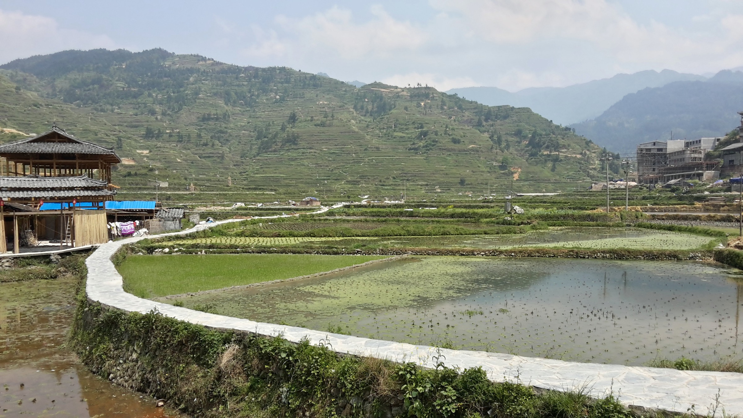
The north flank of Leigong Shan is the densest single area of Miao settlement in China. The tentatively UNESCO-listed cultural landscape of “Miao Nationality Villages in Southeast Guizhou Province” is built around the dozen-plus stilt-house villages on the Bala River catchment. Xijiang Qianhu Miaozhai — the world’s largest single Miao village, with more than 1,432 households, 5,000-plus residents and 99.5 per cent Miao ethnicity — is the cultural anchor of the area, with the Langde Shang (Upper Langde) Miao Ethnic Village Museum and the silver-smithing and Lusheng-pipe villages of Kaijue (开觉), Maliao (麻料), Paika and Datang scattered along the surrounding ridges.
The selected walk operates at two practical scales. The shorter, Xijiang-internal version is the North-Hill viewpoint loop: from the village core, the Number-1 wind-and-rain bridge gives access to either the electric-cart road or a parallel walking path that climbs the opposite north hill to the principal Guanjingtai (Number 1 Viewing Platform, 观景台一号), giving the canonical view across the stilt-house cluster and the Bai River that splits the village into two halves. Walking this circuit (gate area → bridge → North-Hill viewpoint → main pedestrian street → Ga Ge Old Lane) covers roughly 3 km on stone-flag village lanes with a few short stair sections; it is the route feasible inside a half-day visit and on the standard scenic-area ticket.
The longer village-connector walk operates outside the scenic-area gate. Two well-documented variants exist. The southern-side variant takes Langde Xia (Lower Langde) → 1.2 km along the Bala River → Langde Shang (the Qing Dynasty stilt-village museum) → continuing on the surfaced rural road over the connecting hill to Jiaomeng or Paika (Lusheng-pipe village) and on; this route covers several smaller hamlets and rice-paddy terraces over a 10–14 km half-day. The northern-side variant runs Maliao (a small non-touristic Miao hamlet) → Kaijue (silversmith village) → Xijiang, reported as roughly 3.5–4 hours on a zigzag mountain path with terraced-paddy panoramas; in full operator itineraries the chain is published as a 23 km walking day from Yangpai to Xijiang. The Xijiang → Leigongping → Fangxiang traverse, sometimes called the “Kaili classic” at roughly 30 km and 10 hours, is properly a two-day commitment and is not the day-walk selected here.
The walking surface is overwhelmingly cultural: stone-flag village lanes inside the gated villages, earth paths between fields, short surfaced sections on connecting roads. The view rotates between the densely clustered cedar-and-fir stilt houses, the maize-and-rice terraces stair-stepping the ridge sides, and the dark forested wall of Leigong Shan to the south.
Why it is essential
The Miao cultural landscape on the north flank of Leigong Shan is the only living UNESCO-tentative cultural-landscape ensemble in the central Miaoling, and a walking traverse — rather than a coach-tour visit — is the only way to see the silversmith, Lusheng-pipe and “short-skirt Miao” villages in their working agricultural setting. The route is the cultural counterpoint to the four natural landscapes in the selection and the only walk in the five that has no gated scenic-area ticket on its rural sections.
Equipment
- Trail shoes with good grip (stone-flag village lanes are slick when wet)
- Light weatherproof shell
- Sun protection on the open ridge sections
- Water and snacks; village shops in Xijiang, Langde and Paika but not on the connecting paths
- Insect repellent and tick protection in the rice-terrace margins
- Cash (some village stalls and Lusheng-pipe workshops do not accept mobile payment)
- A local guide or recent GPS track on the rural village-to-village connectors; navigation between hamlets is not signed in English
- Respectful clothing inside village houses; ask before photographing residents
Hazards and notes
- Many of the connector paths cross active village agricultural land; stay on the marked rural roads and stone-flag paths.
- The Xijiang scenic area is gated and ticketed; the rural connectors are not, but some village entry-gates levy a separate small fee (Langde Shang traditionally welcomes visitors with the “twelve gates of barring wine”).
- Festival days (Miao New Year, late autumn; Sister’s Meal Festival, lunar mid-March) shut some paths to non-participants and crowd the villages.
- Heavy rain renders the terraced-field paths very slick.
- Dogs at the entrance to small villages are common; carry a walking pole.
- Drone use in inhabited villages requires permission.
Routes and maps
| Source | URL |
|---|---|
| OpenStreetMap — 西江 / Xijiang | openstreetmap.org |
| TravelChinaGuide — 5-day Kaili hiking itinerary | travelchinaguide.com |
| ChinaDiscovery — Langde Miao Village | chinadiscovery.com |
| AsiaOdysseyTravel — Xijiang Miao Village with map | asiaodysseytravel.com |
External links
- UNESCO tentative list — Miao Nationality Villages
- ChinaDiscovery — Xijiang Miao Village
- WindHorseTour — 7 Day Guizhou Minority Village Hiking Tour
- BeijingHikers — Guizhou: Miao and Dong culture in the mountains
5. Zhenyuan Shiping Shan ancient-town ridge
Snapshot
Itinerary
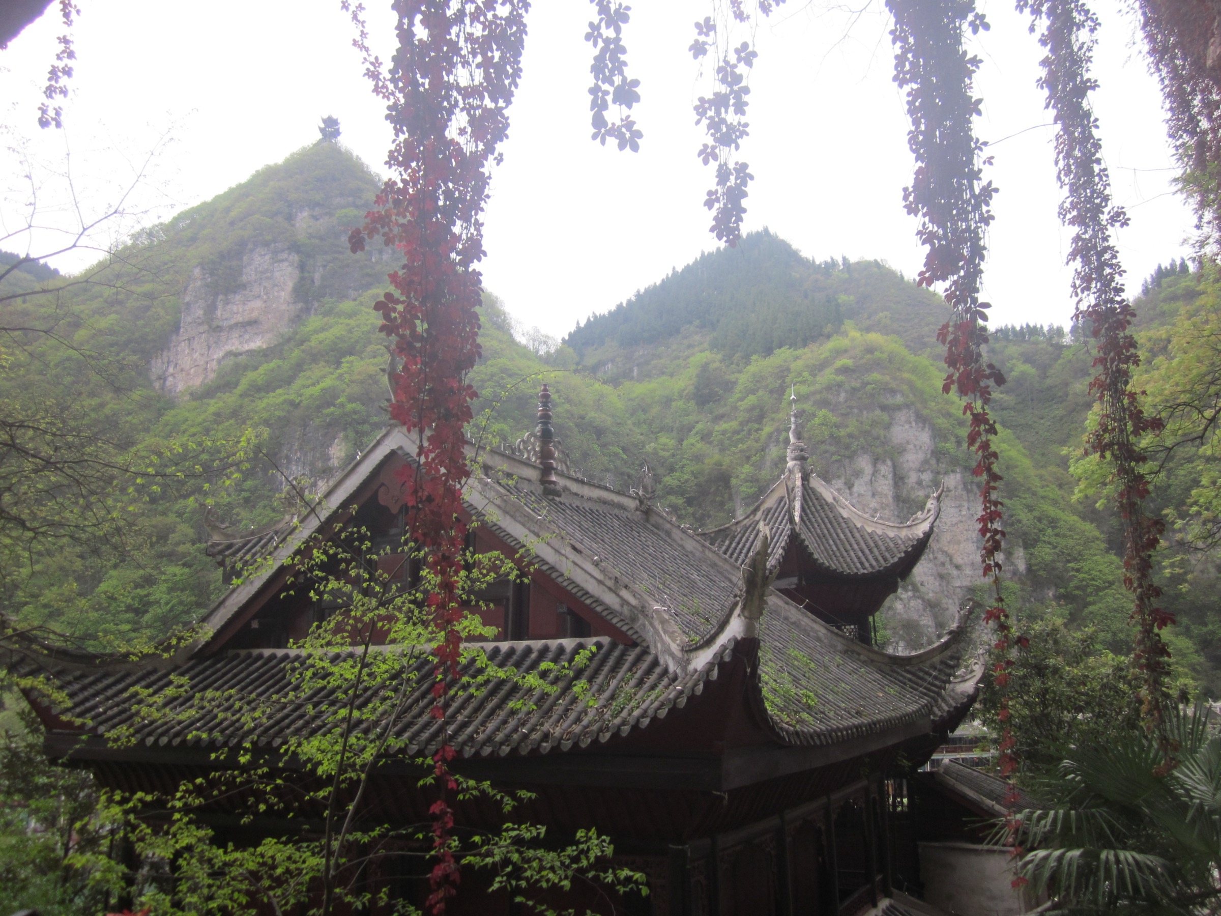
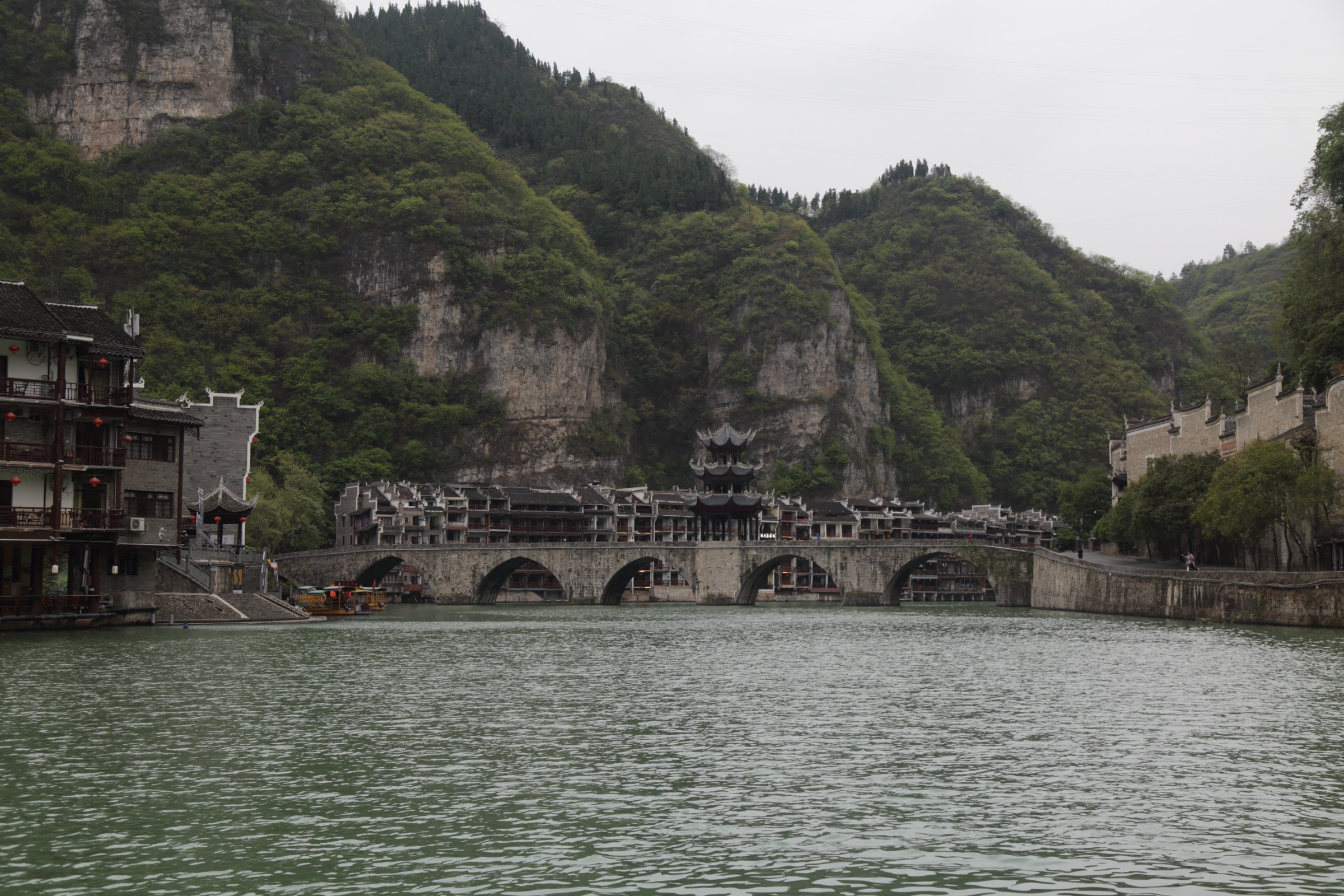
Zhenyuan is the historic military-and-trade prefecture controlling the Wuyang River gorge, the river-corridor that has linked central Guizhou with Hunan since the Han Dynasty. The Wuyang here cuts an S-shaped meander through the limestone-and-metamorphic contact at the eastern edge of the Miaoling, and the old town is built into the gap between the river and the cliffs of Shiping Shan to the north. The mountain is the natural defensive bulwark of the prefecture; the Ming Dynasty Fucheng wall, built during the Zhengde reign in the early sixteenth century, follows the ridge crest for roughly 2 km, with 76 crenels preserved along its length — locally branded the “Great Wall of the South” (苗疆长城).
Two parallel trail accesses leave the old town. The eastern access begins at the north end of Zhusheng Bridge (the late-Ming triple-arch stone bridge with the Kuixing Pavilion on its central span) and climbs north on a flagged stair through forest. The western access threads through the pedestrian Sifangjing Lane (Four-Sided Well Lane, 四方井巷) and Fuxing Lane in the lower old town, then joins the same ridge stair higher up. Either approach gains the published 200 m to the first viewing pavilion in around 20 minutes; the full climb to the summit pavilion takes about 40 minutes.
The summit itself is a built terrace beside the Wanshou Gong (Long-Life Hall). The view down is the canonical photograph: the Wuyang’s S-bend snakes through the old town, the river-front Ming–Qing Huizhou-style merchant houses cluster on both banks, and the Tai Chi-shaped river-and-roof outline becomes obvious only from this height. To the east, the Fucheng wall steps along the ridge for another kilometre, with crenel platforms at intervals, then drops via a separate eastern stair back toward the river — a small loop is possible by descending the eastern stair to rejoin the old-town riverfront. A short south-side spur reaches the Siguan Tang (Hall of the Four Generals, 四关堂), with statues of four Warring States generals; this is the most-photographed Fucheng wall feature and the published end-point of the standard tourist walk.
Why it is essential
Shiping Shan is the only river-canyon viewpoint in the central Miaoling reachable as a half-day walk from a UNESCO-tentative historic old town, and the only walk in the selection that combines a working military-architecture feature (the 2 km Ming Fucheng wall) with a panoramic gorge view. As the only walk in the five that is integrated into a town rather than a gated scenic area, it adds the river-and-historical element that the Leigong summit, Yuntai karst, Maolan forest and Xijiang village walks do not.
Equipment
- Trail shoes with grip (flagged stair is polished and very slick in rain)
- Sun protection on the ridge — the Fucheng wall is exposed
- Water and snacks; the old town is a five-minute descent from any platform
- Light weatherproof shell
- Headtorch for early-morning or evening summit visits (the path is unlit above the first pavilion)
- Cash for the 30 CNY scenic-area ticket (reportedly free before 08:00 and after 17:00–18:00; verify current schedule)
- Insect repellent in summer
Hazards and notes
- Stair surfaces are very slick after rain; the early section above Zhusheng Bridge is steep.
- The Fucheng wall is unfenced in places along the ridge crest; do not lean over the crenels.
- The 30 CNY ticket and the free-entry window times are subject to change; verify on arrival.
- Drone flight over the old town is regulated.
- The summit platform is shared with photographer crowds at sunrise and sunset; arrive early.
- Dogs are not permitted on the inner old-town flagged sections.
Routes and maps
| Source | URL |
|---|---|
| OpenStreetMap — 石屏山 / Shiping Shan | openstreetmap.org |
| Trip.com Moments — Zhenyuan hiking challenge | my.trip.com |
| Trip.com Moments — Shiping Mountain Scenic Area guide | us.trip.com |
| ChinaTrekking — Zhenyuan & Wuyang River | chinatrekking.com |
External links
- IntoTravelChina — Zhenyuan Ancient Town
- ChinaWondersGuide — Zhenyuan Ancient Town & Taiji on the Wuyang River
- Fabio Nodari — Zhenyuan Ancient Town travel guide
- Wikivoyage — Zhenyuan
External links
- UNESCO World Heritage Centre — South China Karst
- UNEP-WCMC World Heritage Datasheet — South China Karst
- UNESCO tentative list — Miao Nationality Villages in Southeast Guizhou Province
- UNESCO Man and the Biosphere — Maolan
- Guizhou Provincial Forestry Bureau — Leigong Shan National Forest Park
- e-Guizhou — Experience Guizhou’s gifts
- PeakVisor — Guizhou Mountains
- Wikipedia — Guizhou
- Wikipedia — South China Karst
- Wikipedia — Xijiang, Guizhou
- Wikipedia — Leishan County
- Wikimedia Commons — Category:Leishan County