Regional overview
Lantau is the largest of Hong Kong’s outlying islands, almost twice the area of Hong Kong Island and roughly 70 per cent protected as country park. The island is dominated by a high spine of granite and volcanic peaks running roughly east to west across the southern half: Sunset Peak (Tai Tung Shan, 869 m), Yi Tung Shan (749 m), Lantau Peak (Fung Wong Shan, 934 m, the second-highest summit in Hong Kong after Tai Mo Shan), and the lower outliers of Nei Lak Shan and Kau Nga Ling. Between Sunset Peak and Lantau Peak the ridge drops sharply to the road pass at Pak Kung Au (around 340 m), the key access col for both summits. West of Lantau Peak, the Ngong Ping plateau holds the Po Lin Monastery and the 34-metre seated Tian Tan Buddha, the most-visited cultural landmark on the island.
The walking is structured around the Lantau Trail, a 70 km waymarked long-distance route in twelve sections managed by the Agriculture, Fisheries and Conservation Department (AFCD). The trail begins and ends at Mui Wo on the eastern coast, climbs over the twin peaks, drops to Ngong Ping and the Big Buddha, descends west to Tai O fishing village on the north-west tip, and traces the southern coast back to Mui Wo via Shek Pik Reservoir, Shui Hau and Pui O. Lantau Country Park covers most of the upland interior in two sections (Lantau North and Lantau South), and AFCD publishes detailed section-by-section route information through its Enjoy Hiking portal.
Access is unusually good for a country-park island: the MTR Tung Chung Line connects Hong Kong to Tung Chung on the north coast, from where New Lantao Bus services 3M, 11, 23 and others reach Mui Wo, Pak Kung Au, Ngong Ping, Tai O and Shek Pik. The Ngong Ping 360 cable car climbs from Tung Chung to Ngong Ping in around 25 minutes, providing a fast approach for the Big Buddha and Lantau Peak descent. Ferries run from Central pier 6 to Mui Wo and from Tuen Mun to Tai O. The best walking season runs from late October through to early March, with cool dry north-easterly weather, low humidity and reliable visibility from the summits; conditions in May to September are hot, humid, prone to thunderstorms, and exposed to typhoons that close trails entirely.
Selection rationale
The five entries cover the two famous twin summits (Lantau Peak for sunrise, Sunset Peak for the silvergrass ridge), the classic long-day traverse over both peaks (Lantau Trail Sections 2-3 from Mui Wo via Pak Kung Au to Ngong Ping), the cultural and contemplative landscape of the Ngong Ping plateau (Tian Tan Buddha, Po Lin Monastery, Wisdom Path), and the coastal-village finish at Tai O (Lantau Trail Sections 5-6 from Man Cheung Po down to the stilt houses). Together they span every signature element of the island: granite summit, ridge balcony, monastic plateau, and traditional fishing village, with trailheads spread along the AFCD Lantau Trail rather than clustered at a single car park.
Summary table
| # | Hike | Country | Route type | Distance | Gain | Max elevation | Difficulty |
|---|---|---|---|---|---|---|---|
| 1 | Lantau Peak from Pak Kung Au (Lantau Trail Section 3) | Hong Kong | Point-to-point | 4.5 km | 600 m | 934 m | Hard |
| 2 | Sunset Peak from Pak Kung Au (Lantau Trail Section 2 reversed) | Hong Kong | Out-and-back | 6.5 km | 530 m | 869 m | Hard |
| 3 | Lantau Trail Sections 2-3: Mui Wo - Pak Kung Au - Ngong Ping (twin peaks) | Hong Kong | Point-to-point | 13.5 km | 1,250 m | 934 m | Very hard |
| 4 | Ngong Ping plateau circuit: Tian Tan Buddha, Po Lin, Wisdom Path, Nei Lak Shan loop | Hong Kong | Loop | 5 km | 250 m | 750 m | Moderate |
| 5 | Lantau Trail Sections 5-6: Sham Wat Road to Tai O via Man Cheung Po | Hong Kong | Point-to-point | 10 km | 350 m | 250 m | Moderate |
1. Lantau Peak from Pak Kung Au (Lantau Trail Section 3)
Snapshot
Itinerary
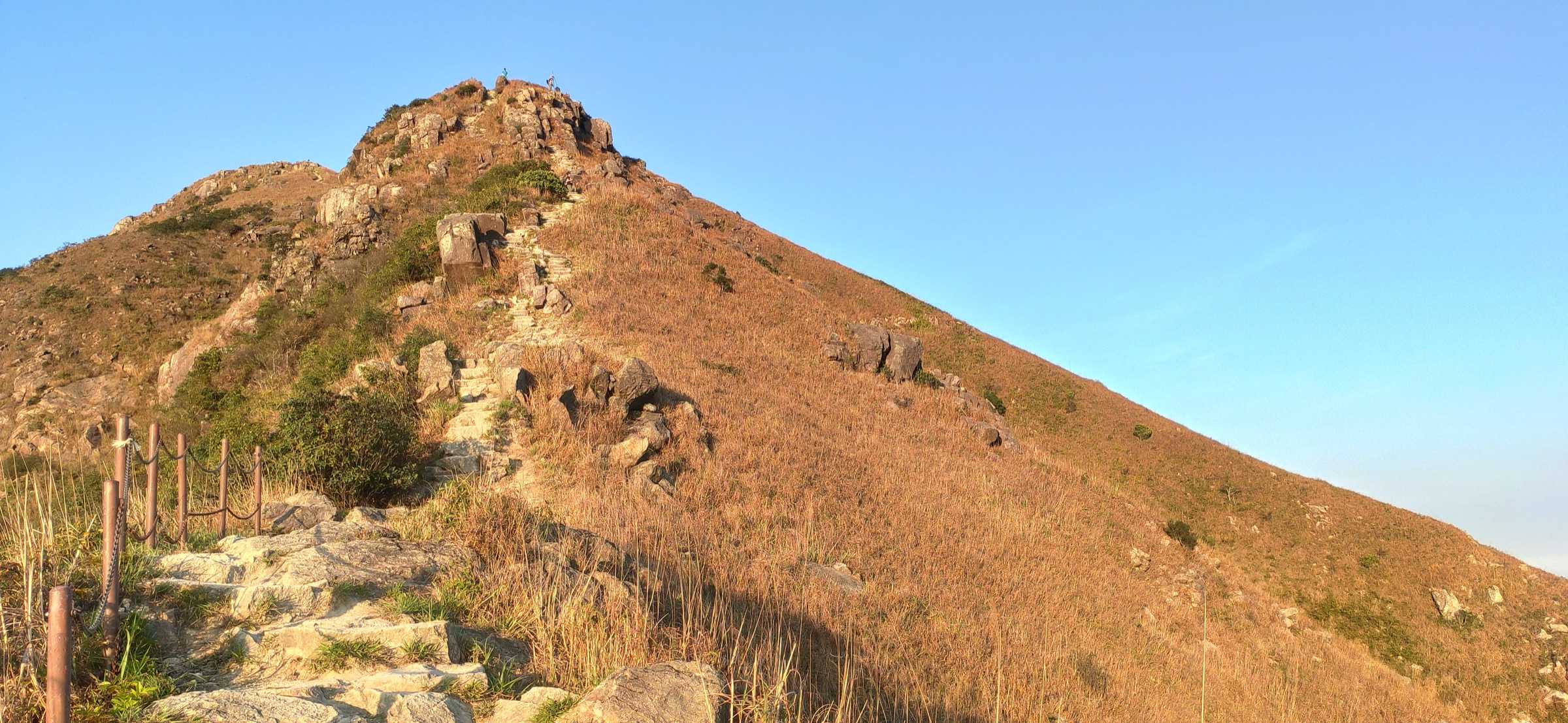
Section 3 of the Lantau Trail leaves Pak Kung Au from the marked AFCD signpost on the south side of Tung Chung Road, climbs immediately into the conifer plantation, and then breaks out onto an exposed ridge of stone steps that rise relentlessly for around 1.5 km to the lower shoulder of Fung Wong Shan. From the shoulder, a short rocky scramble leads to the twin summit knolls — Wong Fung (the lower, eastern dome) and Fung Fung (the higher, western dome) — at 934 m, the second-highest point in Hong Kong. The summit panorama takes in Macau and the Pearl River estuary to the west, the Ngong Ping plateau and Big Buddha directly below to the west, Sunset Peak across Pak Kung Au to the east, and the South China Sea to the south. The descent runs steeply west on more stone staircase down to Ngong Ping, where the section finishes near the Po Lin Monastery and the Tian Tan Buddha.
Why it is essential
Lantau Peak is the iconic sunrise summit of Hong Kong: a classic pre-dawn ascent from Pak Kung Au with the Big Buddha appearing out of cloud at first light is the single most photographed mountain experience in the territory. The peak is the highest point of Lantau Island, the second-highest in Hong Kong, and the natural high point of any Lantau Trail traverse.
Equipment
Mountain hiking kit: sturdy trail shoes or boots with good grip on slick stone, head torch (essential for pre-dawn sunrise attempts), warm and windproof layer for the exposed summit, sun protection, plentiful water (no reliable refill on route), trekking poles for the steep descent. Carry food for a long pre-dawn start.
Hazards and notes
The stone staircase is exposed, steep and slippery when wet; descents are harder on the knees than the ascent. Summit weather can be cold and very windy even when Tung Chung is mild. Cloud commonly fills the col by mid-morning. The cable car from Ngong Ping back to Tung Chung is the quickest exit but does not run before 10:00 — sunrise walkers should plan for the bus or a longer wait. Lantau North and South Country Parks are managed by AFCD; stay on marked trails to avoid damage to montane shrubland.
GPX / KML links
| Source | URL |
|---|---|
| AFCD Enjoy Hiking: Lantau Trail Section 3 (Pak Kung Au to Ngong Ping) | hiking.gov.hk |
| AllTrails: Lantau Trail Section 3 | alltrails.com |
| AllTrails: Lantau Peak Trail | alltrails.com |
| Hikingbook: Lantau Trail Section 3 from Pak Kung Au to Ngong Ping | hikingbook.net |
2. Sunset Peak from Pak Kung Au (Lantau Trail Section 2 reversed)
Snapshot
Itinerary
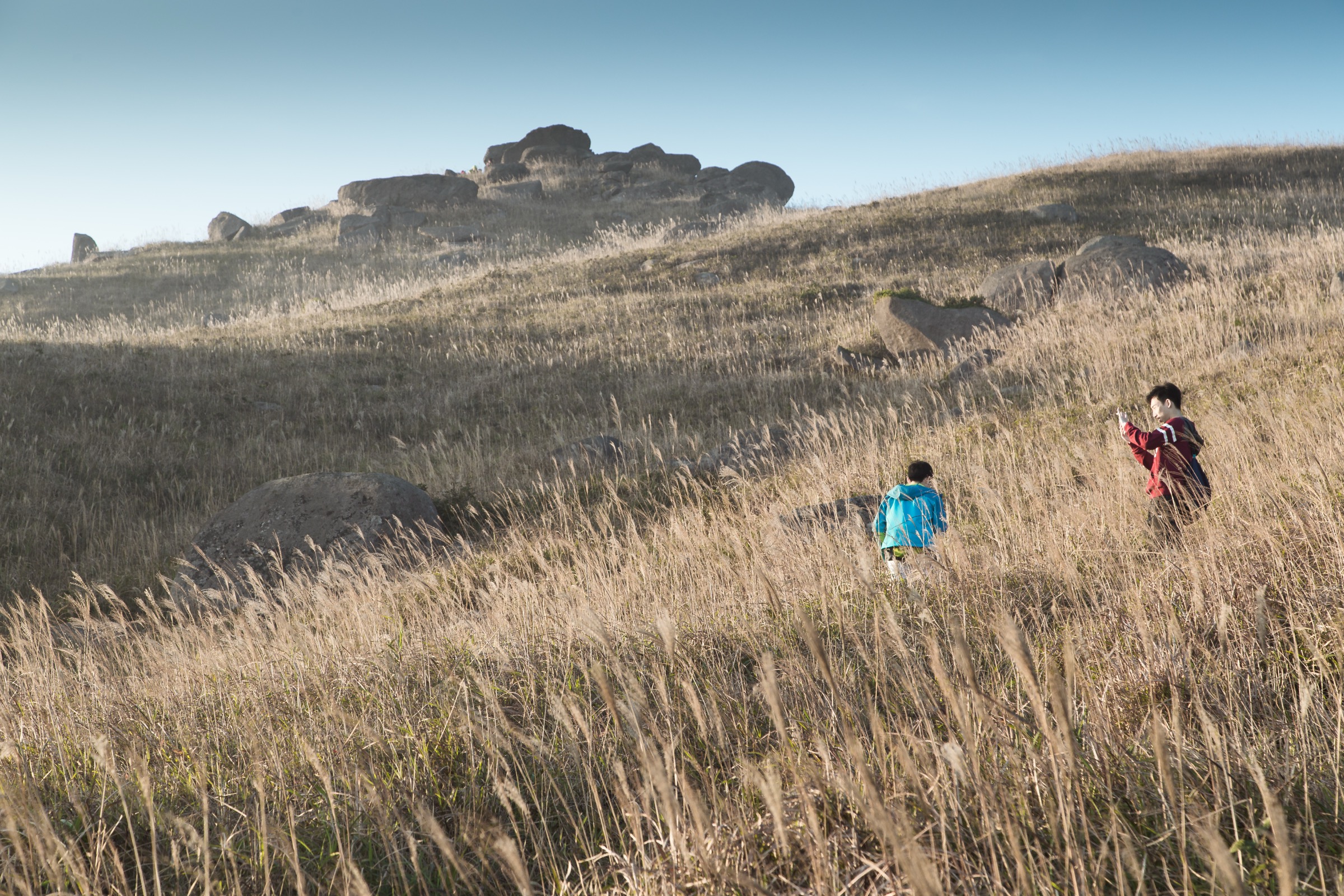
From the Pak Kung Au bus stop, a stepped path on the north side of Tung Chung Road climbs steeply through scrub onto the southern shoulder of Sunset Peak. The gradient eases briefly across a broad grassy bench occupied by a cluster of stone retreat huts (built in the 1920s by missionaries and still used as private rest huts), then resumes climbing along the open ridge to the triangulation pillar at 869 m. From the summit, the ridge falls gradually north-east towards Yi Tung Shan and Nam Shan, but the standard day-hike returns by the same line to Pak Kung Au. In autumn, the broad upper slopes are densely covered in silvergrass (Miscanthus), giving the peak its photographic reputation.
Why it is essential
Sunset Peak is the classic sunset counterpart to Lantau Peak: third-highest summit in Hong Kong, the longest unbroken open-ridge walk on the island, and the headline silvergrass landscape of the autumn hiking season. Combined with Lantau Peak across Pak Kung Au, the two summits form the famous twin-peak crown of Lantau and the structural core of Sections 2 and 3 of the Lantau Trail.
Equipment
Mountain hiking kit: boots with good grip, warm windproof layer (the summit ridge is significantly cooler and windier than the road pass), head torch for sunset descents, sun protection, plentiful water (no refill on route), trekking poles useful on the descent. A buff or beanie is sensible from November onwards.
Hazards and notes
The summit ridge is open and very exposed in wind, rain or thunderstorms; turn back if storms threaten. The descent on slick stone steps is hard on knees. The stone huts on the upper bench are private and not for public shelter. Cloud can swallow the ridge within minutes. Carry a head torch if returning at sunset, and budget extra time — bus services on Tung Chung Road thin out after dark.
GPX / KML links
| Source | URL |
|---|---|
| AFCD Enjoy Hiking: Lantau Trail Section 2 (Nam Shan to Pak Kung Au, includes Sunset Peak) | hiking.gov.hk |
| AllTrails: Sunset Peak via Lantau Trail | alltrails.com |
| AllTrails: Sunset Peak via North Ridge | alltrails.com |
| AllTrails: Lantau Trail Section 2 | alltrails.com |
3. Lantau Trail Sections 2-3: Mui Wo to Ngong Ping over the twin peaks
Snapshot
Itinerary
The route follows Sections 2 and 3 of the official Lantau Trail in sequence. From Nam Shan, Section 2 climbs through plantation then rises onto the open Sunset Peak ridge, traversing the broad grassy bench past the stone huts to the 869 m summit. The trail then drops steeply on stone staircase to Pak Kung Au at around 340 m, the major road crossing on Tung Chung Road. Section 3 immediately climbs the south face of Fung Wong Shan, gaining roughly 600 m on a relentless stone staircase to the 934 m summit of Lantau Peak, before descending equally steeply west to the Ngong Ping plateau and the Big Buddha. Walkers in good fitness who start early can finish in time for the last cable car down from Ngong Ping; most parties allow a full day with daylight to spare.
Why it is essential
This is the canonical big-day traverse of Lantau, joining the two famous summits on the same outing across the central spine. The Lantau Trail follows the exact line, so the route is signed throughout, and the Nam Shan-Pak Kung Au-Ngong Ping sequence is the only practical way to cover both peaks back-to-back in a day. It is widely considered the most demanding and most rewarding long day-walk in Hong Kong.
Equipment
Mountain hiking kit: stiff boots with good grip, head torch (essential), warm windproof layer, sun protection, at least 2.5 to 3 litres of water (Pak Kung Au has no shop and the only reliable refill on route is at Ngong Ping), salty snacks, trekking poles strongly recommended for both descents. Carry a basic first-aid kit and a printed or offline map; phone signal is variable on the ridges.
Hazards and notes
The combined ascent of around 1,250 m makes this a serious day for unconditioned walkers; many parties underestimate the second climb to Lantau Peak. There is no escape route between Pak Kung Au and Ngong Ping. Both summit ridges are very exposed in wind, rain, and thunderstorms; do not attempt in unstable weather. Cable car timetables and bus schedules tighten in winter — confirm the last service before starting. Trails are managed by AFCD; carry out all waste.
GPX / KML links
| Source | URL |
|---|---|
| AFCD Enjoy Hiking: Lantau Trail overview (all 12 sections) | hiking.gov.hk |
| AllTrails: Sunset Peak and Lantau Peak via Mui Wo | alltrails.com |
| AllTrails: Lantau Trail Section 2 | alltrails.com |
| AllTrails: Lantau Trail Section 3 | alltrails.com |
4. Ngong Ping plateau circuit: Tian Tan Buddha, Po Lin, Wisdom Path
Snapshot
Itinerary
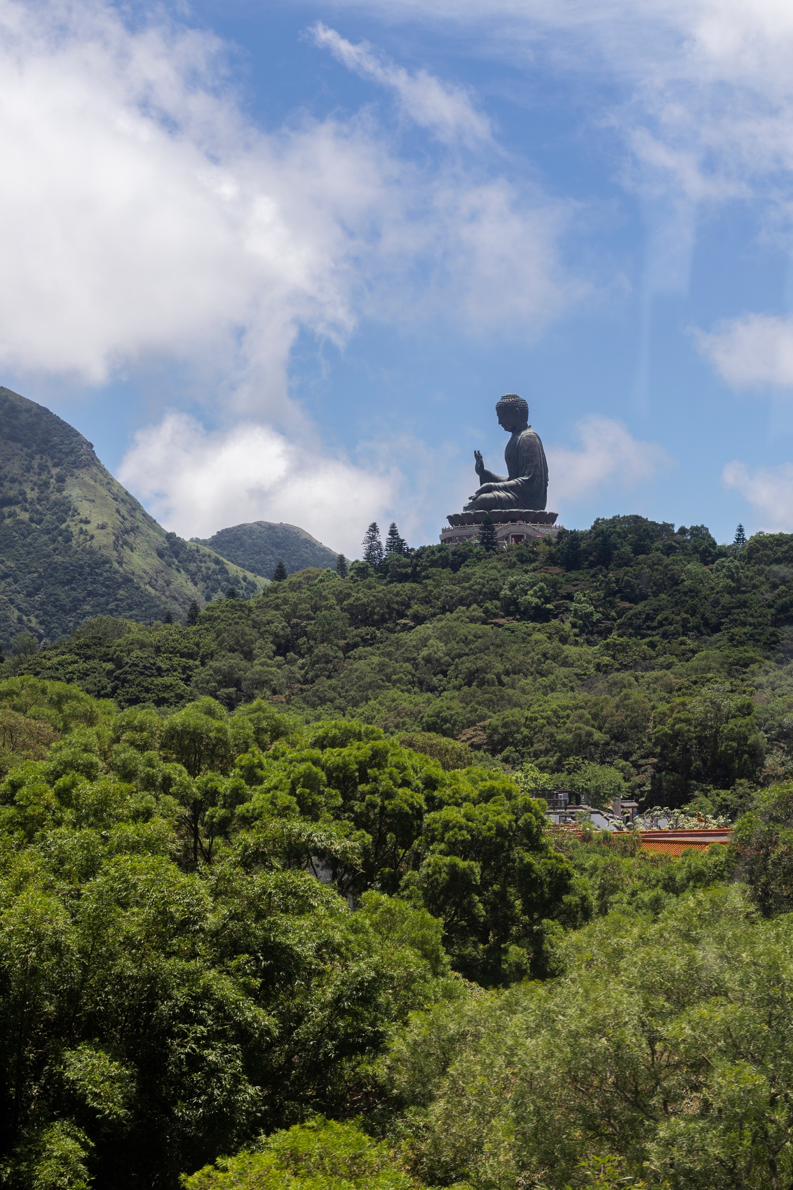
The circuit begins at the cable car upper terminal, follows the paved walkway through Ngong Ping Village past Po Lin Monastery, and turns up the 268-step ceremonial staircase to the foot of the Tian Tan Buddha — a 26.4 m bronze statue (34 m including the lotus throne and pedestal) cast in 1993 and seated facing north towards mainland China. From the base of the Buddha a paved track contours east through pine plantation to the Wisdom Path, a figure-of-eight installation of 38 standing timber columns inscribed with the Heart Sutra in Chinese calligraphy, set on the lower slopes of Nei Lak Shan with views back across the plateau to the Buddha. A short extension climbs the marked Nei Lak Shan trail for higher panoramas before looping back through the Ngong Ping Tree Walk to the bus terminus.
Why it is essential
The Ngong Ping plateau is the cultural heart of Lantau: the Po Lin Monastery, founded by three monks in 1906, and the Tian Tan Buddha together form one of the most-visited religious landmarks in Hong Kong, while the Wisdom Path adds a quiet outdoor literary monument set against the southern flank of Lantau Peak. The loop is the only entry in this selection accessible to walkers of all abilities and the natural rest-day or recovery walk after the summit hikes.
Equipment
Standard hiking equipment: comfortable walking shoes, sun protection, water, light layer for the cable car descent, and a small camera. No technical kit required. Modest dress is expected within the monastery precincts.
Hazards and notes
The Buddha staircase is busy, and the upper plateau exposed in winter wind. The Po Lin Monastery and statue have set opening hours (typically 10:00 to 17:30); confirm before travelling. The cable car can close in high winds or for maintenance — check the Ngong Ping 360 website. The vegetarian restaurant at Po Lin Monastery is a popular lunch stop. Stay on marked paths beyond the Wisdom Path; the upper Nei Lak Shan ridge is rougher than the paved plateau routes.
GPX / KML links
| Source | URL |
|---|---|
| AllTrails: Wisdom Path and Ngong Ping Tree Trail | alltrails.com |
| AllTrails: Tian Tan Buddha at Ngong Ping Village | alltrails.com |
| Komoot: Wisdom Path - Ngong Ping and Tian Tan Buddha loop from Tung Chung | komoot.com |
5. Lantau Trail Sections 5-6: Sham Wat Road to Tai O via Man Cheung Po
Snapshot
Itinerary
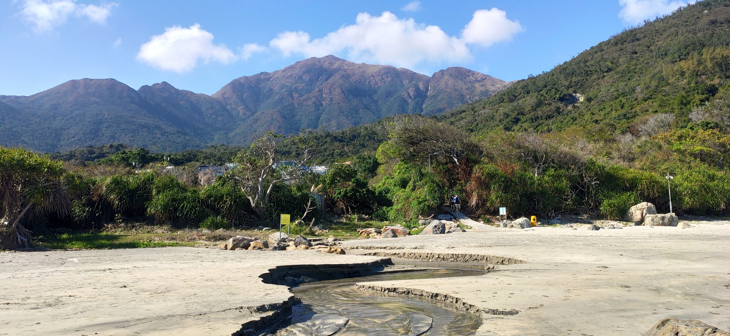
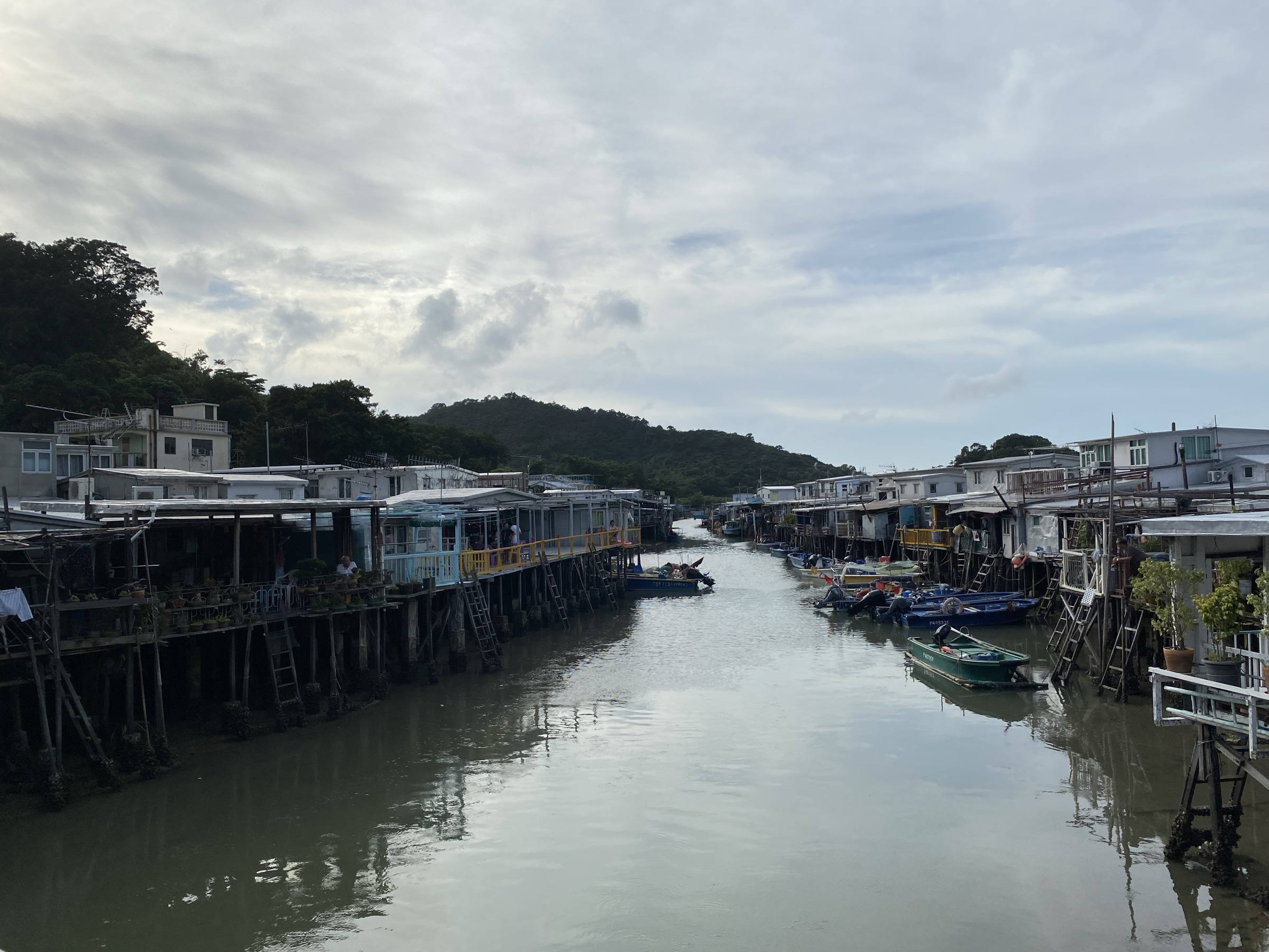
Section 5 leaves the Sham Wat Road signpost and contours west and then south through low scrub above the coast, with intermittent views across the Pearl River estuary towards Zhuhai and the Hong Kong-Zhuhai-Macau Bridge. After approximately 7.5 km of undulating ridge and forested gully walking the route arrives at Man Cheung Po, a small reservoir and pumping station in a quiet wooded basin. Section 6 then climbs briefly onto the final coastal shoulder and descends through woodland on stone steps for around 2.5 km to the eastern edge of Tai O village. The route ends among the stilt houses on the Tai O River, with the village waterfront, market and small temples a short walk away.
Why it is essential
This is the classic coastal finish to the Lantau Trail and the only marked walking approach to Tai O — Hong Kong’s best-preserved traditional fishing village, founded several hundred years ago and famous for its Tanka-style stilt houses, salt-pan history, dried-seafood market and pink-dolphin boat trips. The route combines a quiet inland ridge section with a fine arrival into a working coastal village, and it complements the high summit days higher up the ridge.
Equipment
Standard hiking equipment: trail shoes with grip, sun hat (most of the route is exposed), at least 1.5 to 2 litres of water (no refill until Tai O), sun cream, light shell layer for sea breeze on the upper ridges. Bring small change for the village markets and ferries.
Hazards and notes
The upper ridge is exposed to sun and wind; summer attempts risk heat exhaustion. The Man Cheung Po area is overgrown in places and route-finding becomes harder after typhoons. Tides and weather can disrupt the small Tai O ferry to Tuen Mun. Tai O village is a living settlement — be respectful when photographing residents and stilt houses. Bus services from Tai O thin out in the late afternoon; check the last departure before starting.
GPX / KML links
| Source | URL |
|---|---|
| AFCD Enjoy Hiking: Lantau Trail overview (Sections 5 and 6) | hiking.gov.hk |
| Lantau Island guide: Lantau Trail complete hiking guide | lantau-island.com |
| Thru-Hiking HK: The Lantau Trail (section breakdown) | thruhikinghk.com |
External links
| Source | URL |
|---|---|
| AFCD Enjoy Hiking — Lantau Trail (long trail overview) | hiking.gov.hk |
| AFCD Enjoy Hiking — Lantau Trail Section 3 (Pak Kung Au to Ngong Ping) | hiking.gov.hk |
| Hong Kong Tourism Board — Lantau Peak | discoverhongkong.com |
| Hong Kong Tourism Board — Sunset Peak | discoverhongkong.com |
| Hong Kong Tourism Board — The Big Buddha | discoverhongkong.com |
| Hong Kong Tourism Board — Tai O Village | discoverhongkong.com |
| Wikipedia — Lantau Island | en.wikipedia.org |
| Wikipedia — Lantau Peak | en.wikipedia.org |
| Wikipedia — Sunset Peak (Hong Kong) | en.wikipedia.org |
| Wikipedia — Lantau Trail | en.wikipedia.org |
| Wikipedia — Tian Tan Buddha | en.wikipedia.org |
| Wikipedia — Po Lin Monastery | en.wikipedia.org |
| Wikipedia — Tai O | en.wikipedia.org |
| PeakVisor — Lantau Peak | peakvisor.com |
| PeakVisor — Sunset Peak | peakvisor.com |
| AllTrails — Lantau Trail Section 2 | alltrails.com |
| AllTrails — Lantau Trail Section 3 | alltrails.com |
| AllTrails — Sunset Peak via Lantau Trail | alltrails.com |
| AllTrails — Sunset Peak and Lantau Peak via Mui Wo | alltrails.com |
| AllTrails — Wisdom Path and Ngong Ping Tree Trail | alltrails.com |
| AllTrails — Tian Tan Buddha at Ngong Ping Village | alltrails.com |
| Komoot — Wisdom Path, Ngong Ping and Tian Tan Buddha loop from Tung Chung | komoot.com |
| Lantau Island guide — Lantau Trail complete hiking guide | lantau-island.com |
| Thru-Hiking HK — The Lantau Trail | thruhikinghk.com |
| Ngong Ping 360 — Big Buddha | np360.com.hk |
| Wikimedia Commons — Lantau Peak category | commons.wikimedia.org |
| Wikimedia Commons — Tian Tan Buddha category | commons.wikimedia.org |
| Wikimedia Commons — Tai O category | commons.wikimedia.org |