Regional overview
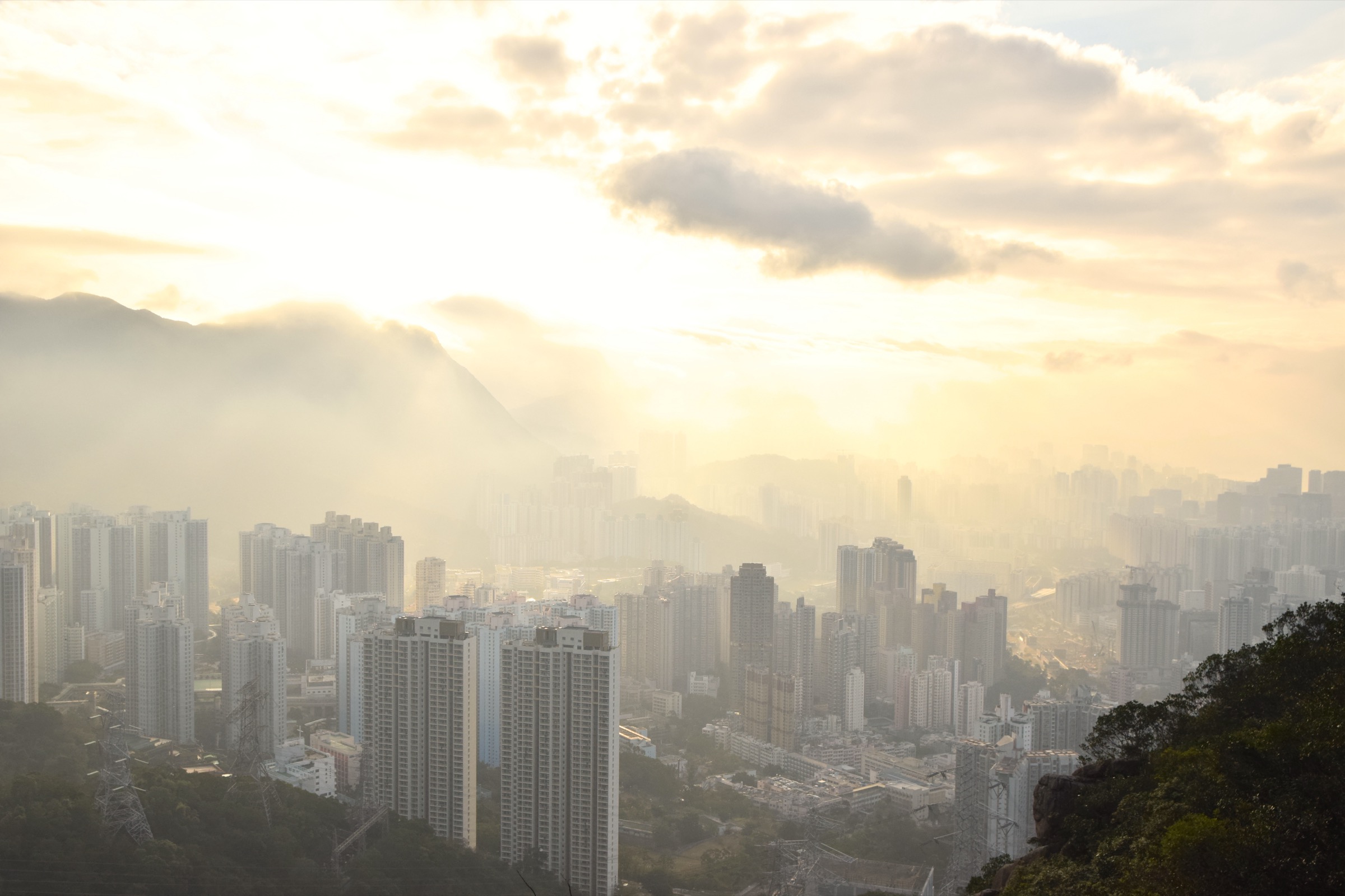
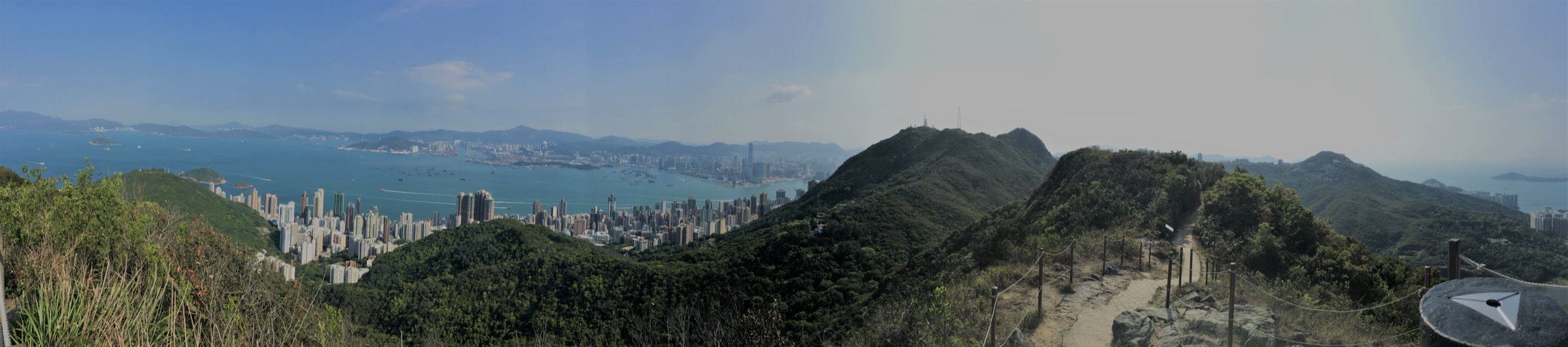
Hong Kong Island runs east to west along a tight volcanic and granite spine that rises from the South China Sea to Victoria Peak at 552 m, Mount Parker at 532 m, Mount Cameron at 439 m and the long ridge of Violet Hill, The Twins and Shek O Peak that closes off the southern coast. Although the island is only about 80 km², roughly two thirds of its area lies inside designated country parks — Pok Fu Lam, Aberdeen, Tai Tam and Shek O — managed by the Agriculture, Fisheries and Conservation Department (AFCD). The result is one of the densest urban-mountain hiking networks anywhere in the world, with high ridges, granite reservoirs and panoramic coastal headlands all sitting within a short MTR ride of Central.
The 50-km Hong Kong Trail traces the spine from The Peak in the west to Tai Long Wan (Big Wave Bay) in the east, divided into eight signposted sections with markers every 500 m. Wilson Trail Section 1 crosses the southern ridge between Wong Nai Chung Gap and Stanley Gap over Violet Hill and the steep stair-stacks of The Twins. Lower-key walks circle Victoria Peak on Lugard and Harlech Roads, climb High West for an aerial view of the harbour, and traverse Mount Parker on cobbled service roads built for the colonial reservoirs of Tai Tam. AFCD publishes free maps, gradient profiles and trail-condition updates online, and most trailheads are reached directly by bus, minibus or MTR.
The best walking conditions run from late October to March, when the north-easterly monsoon brings cool, dry, clear weather with daytime temperatures around 15-22 C. From late May to September the island is hot, intensely humid and exposed to typhoons; trails on the open ridges of Dragon’s Back, Violet Hill and The Twins offer little shade, and Hong Kong Observatory thunderstorm and Black Rainstorm warnings routinely force AFCD to close country parks at short notice. Drinking water is rarely available on the ridges, and the granite-and-stair tread becomes treacherously slick after rain.
Selection rationale
The five entries combine the world-famous coastal ridge walk (Dragon’s Back as Hong Kong Trail Section 8), the iconic urban panorama loop around the highest summit (the Peak Circle Walk on Lugard and Harlech Roads), a representative inner-section of the Hong Kong Trail descending past the colonial-era Pok Fu Lam Reservoir, the most demanding ridge crossing on the southern side of the island (Violet Hill and The Twins on Wilson Trail Section 1), and the classic eastern reservoir-and-summit traverse over Mount Parker between Tai Tam and Quarry Bay. They spread across all four Hong Kong Island country parks, cover a balanced mix of summit, ridge, viewpoint, reservoir and coastal character, and combine well-marked AFCD infrastructure with the harder ridge work that defines the island’s hill walking.
Summary table
| # | Hike | Country | Route type | Distance | Gain | Max elevation | Difficulty |
|---|---|---|---|---|---|---|---|
| 1 | Dragon’s Back — Hong Kong Trail Section 8 (To Tei Wan to Big Wave Bay) | Hong Kong | Point-to-point | 8.5 km | 490 m | 284 m | Moderate |
| 2 | Peak Circle Walk (Lugard Road and Harlech Road) | Hong Kong | Loop | 3.5 km | 50 m | 440 m | Easy |
| 3 | Hong Kong Trail Section 1 — The Peak to Pok Fu Lam Reservoir | Hong Kong | Point-to-point | 7.0 km | 160 m | 500 m | Moderate |
| 4 | Violet Hill and The Twins — Wilson Trail Section 1 | Hong Kong | Point-to-point | 4.8 km | 630 m | 433 m | Hard |
| 5 | Mount Parker traverse (Tai Tam to Quarry Bay over the summit) | Hong Kong | Point-to-point | 8-9 km | 560 m | 532 m | Moderate-Hard |
1. Dragon’s Back — Hong Kong Trail Section 8 (To Tei Wan to Big Wave Bay)
Snapshot
Itinerary
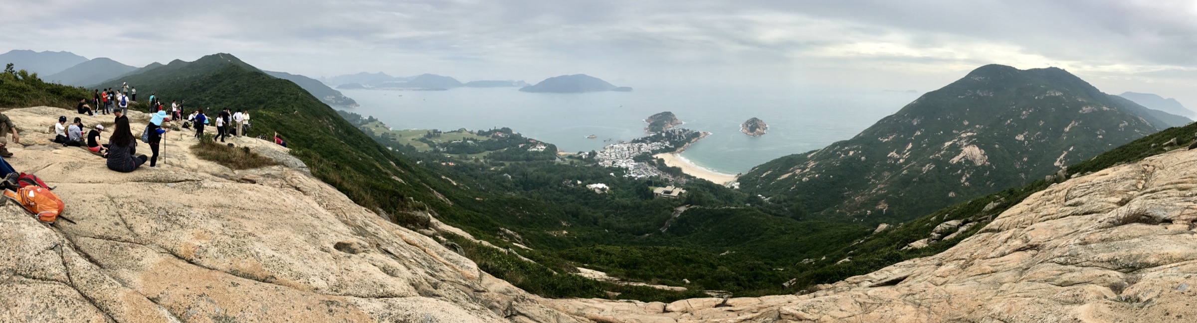
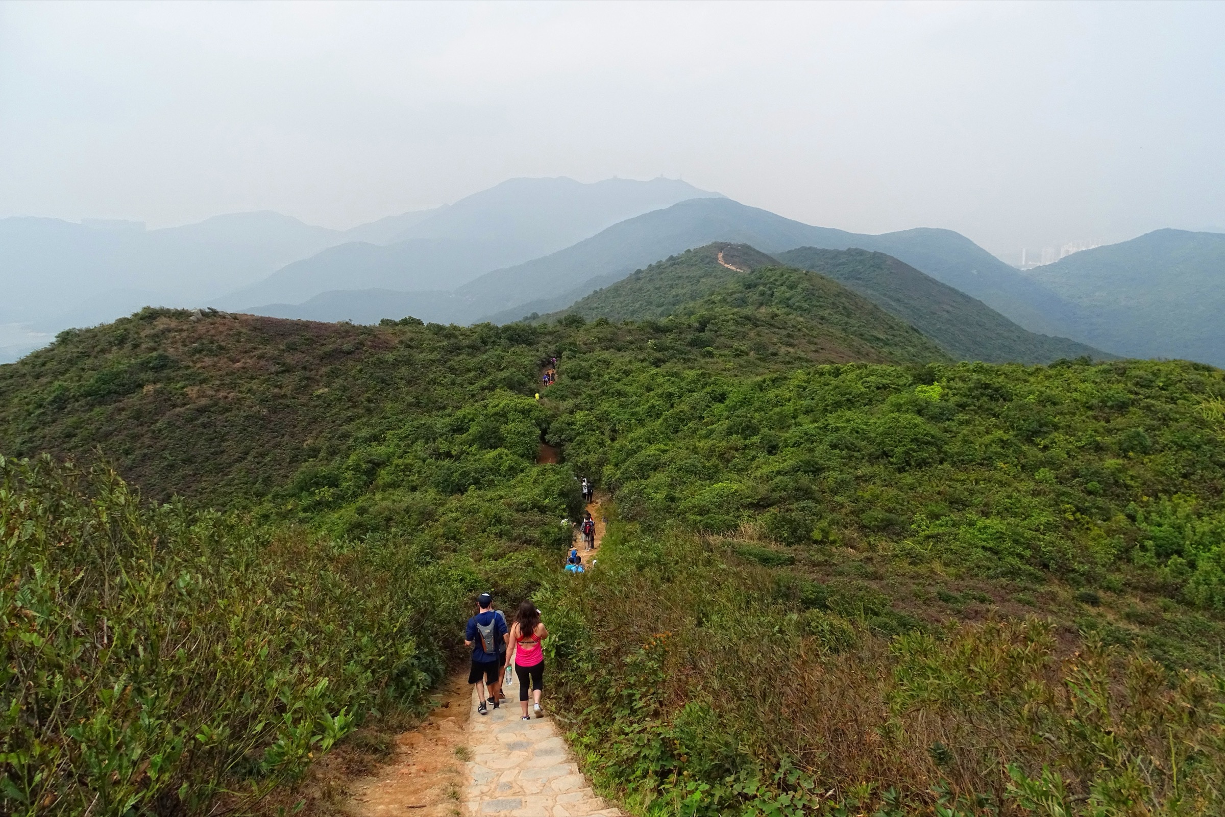
The route leaves Shek O Road at the To Tei Wan trailhead — clearly signed as Hong Kong Trail Stage 8 — and climbs a long flight of concrete steps up the southern flank of the ridge to a saddle, then continues along the open rocky crest known as the Dragon’s Back. The skyline undulates over Shek O Peak (284 m) and a series of lower humps with sweeping views east to Shek O village and Tai Tau Chau, south to D’Aguilar Peninsula and the open South China Sea, and north over Tai Tam Harbour to the inner ridges of the island. Beyond the high point the trail drops to a paved access road, swings down to Pottinger Gap, and follows a forested track down to Big Wave Bay, where a short walk through the village reaches the beach, surf cafés and the bus stop.
Why it is essential
The Dragon’s Back is the single most famous walk in Hong Kong: Time Asia named it the best urban hike in Asia in 2004, and CNN later included it in its list of the world’s best trails. The combination of an open, narrow rocky ridge with full 360-degree coast-and-island views, low absolute altitude (no acclimatisation needed), and a finish on a swimmable beach makes it the defining essential day-hike of Hong Kong Island. It is also the closing section of the 50-km Hong Kong Trail, giving it a dual identity as both a stand-alone classic and the natural finishing leg of the island’s flagship long-distance route.
Equipment
Standard hiking shoes with good grip on smoothed granite and concrete steps, sun hat, sunglasses, plenty of water (no reliable potable supply on the ridge), light wind layer for the exposed crest, and insect repellent for the forested descent. Trekking poles help on the long stair descent to Pottinger Gap. Swimwear and a towel are worth carrying for the finish at Big Wave Bay.
Hazards and notes
The ridge is fully exposed to sun and wind; heat-stroke is a real risk in summer. The route is closed or strongly discouraged when Hong Kong Observatory issues amber-or-above rainstorm or typhoon signal 3 warnings. The narrow upper crest can be slippery after rain and crowded on weekends. Mobile coverage is good but battery drains quickly in heat — carry a power bank if relying on GPS. The route is part of the annual Oxfam Trailwalker course (Hong Kong’s biggest charity ultra), so expect heavy traffic on late-November weekends.
GPX / KML links
| Source | URL |
|---|---|
| AFCD Enjoy Hiking: Hong Kong Trail Section 8 | hiking.gov.hk |
| AllTrails: Hong Kong Trail Section 8 (Dragon’s Back to Big Wave Bay) | alltrails.com |
| Hiking Trail HK: Hong Kong Trail Section 8 | hikingtrailhk.appspot.com |
| Komoot: Dragon’s Back to Big Wave Bay | komoot.com |
2. Peak Circle Walk (Lugard Road and Harlech Road)
Snapshot
Itinerary
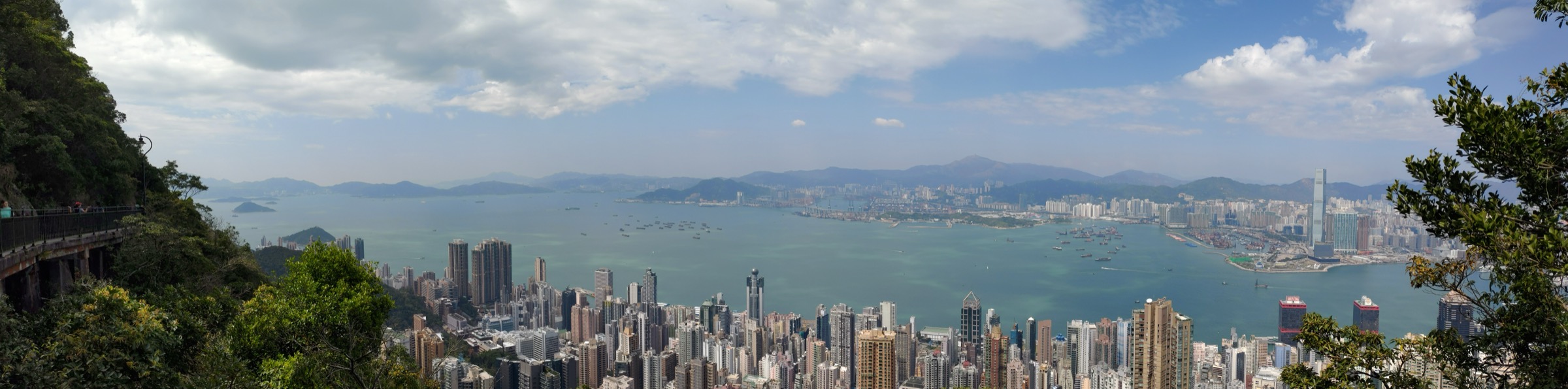
From the Peak Tower the walk follows Lugard Road westwards on a near-level cliffside terrace that contours the northern flank of Victoria Peak above Central, Sheung Wan and the harbour. After roughly 1.4 km Lugard Road meets Harlech Road at the western end of the loop, near a short flight of steps to High West. Harlech Road continues back to Victoria Gap along the southern side of the summit, with through-the-trees views over Pok Fu Lam, Cyberport and the islands of Lamma and Cheung Chau. Walkers who want the actual summit add a short ascent up Mount Austin Road to the Victoria Peak Garden at 552 m, the formal highest point of Hong Kong Island.
Why it is essential
This is the iconic short walk of Hong Kong: the railed Lugard Road terrace gives the city’s signature view down onto Victoria Harbour and the Kowloon skyline, and the loop links the colonial-era hill station infrastructure of the Peak with the modern Peak Tower. It is the only walk in this selection that is suitable for visitors of any fitness level, works as a sunrise, sunset or after-dinner outing, and complements the longer hikes by offering the headline panorama with no significant climb.
Equipment
No special equipment is needed. Comfortable shoes, water, sun protection and a light layer for the exposed western lookouts are sufficient. A torch is useful for night walks after sunset, though the road is partially lit.
Hazards and notes
Lugard Road is narrow and shared with the occasional service vehicle and with cyclists; stay to the inside on blind corners. Cloud and haze frequently smother the harbour view from late morning onwards, so an early start improves photography. The Peak Tram queues at peak hours can exceed an hour — consider bus 15 as an alternative. Surrounding trails into Pok Fu Lam Country Park are unlit; carry a torch if extending the loop towards High West late in the day.
GPX / KML links
| Source | URL |
|---|---|
| Hong Kong Tourism Board: Peak Circle Walk | discoverhongkong.com |
| AllTrails: Victoria Peak Loop | alltrails.com |
| Komoot: Peak Circle Walk (Lugard and Harlech Roads) | komoot.com |
3. Hong Kong Trail Section 1 — The Peak to Pok Fu Lam Reservoir
Snapshot
Itinerary
Section 1 of the Hong Kong Trail starts at the Lugard Road / Harlech Road junction on the western shoulder of Victoria Peak and follows a paved contour path down through the forested western slopes of Pok Fu Lam Country Park. It passes the head of the Pok Fu Lam catchwater, swings south below Mount Davis, and contours steadily downhill with intermittent views over the western channel to Lamma Island. After roughly 5.5 km the trail reaches Pok Fu Lam Reservoir — the first reservoir built in Hong Kong, completed in 1863 — and follows the reservoir road past the historic dam and valves house to Pok Fu Lam Road, where buses run towards Central and Aberdeen. Trail markers in the AFCD system appear every 500 m, making navigation straightforward.
Why it is essential
Section 1 is the canonical opening leg of the 50-km Hong Kong Trail and the most direct way to combine the iconic Lugard Road panorama with a descent through native woodland into one of the most historically important pieces of colonial water infrastructure on the island. It is shaded, well graded, and connects two ends of the public-transport network, making it the model “city escape” hike that the country park system was designed for.
Equipment
Standard hiking shoes, sun protection for the open upper sections, water, snacks and a light shell. A head torch is useful in winter when daylight is short. No technical kit is required.
Hazards and notes
The catchwater path is shared with cyclists in places and can be slippery after rain. The Pok Fu Lam Reservoir area is a protected drinking-water catchment — swimming and informal camping are prohibited. Mobile coverage is good. Trails close in the country park boundary after typhoon signal 8 or Black Rainstorm warnings; AFCD posts updates online.
GPX / KML links
| Source | URL |
|---|---|
| AFCD Enjoy Hiking: Hong Kong Trail Section 1 | hiking.gov.hk |
| AllTrails: Hong Kong Trail Section 1 | alltrails.com |
| Round Island Trail: Hong Kong Trail (Section 1) The Peak to Pok Fu Lam Reservoir | roundislandtrail.gov.hk |
4. Violet Hill and The Twins — Wilson Trail Section 1
Snapshot
Itinerary
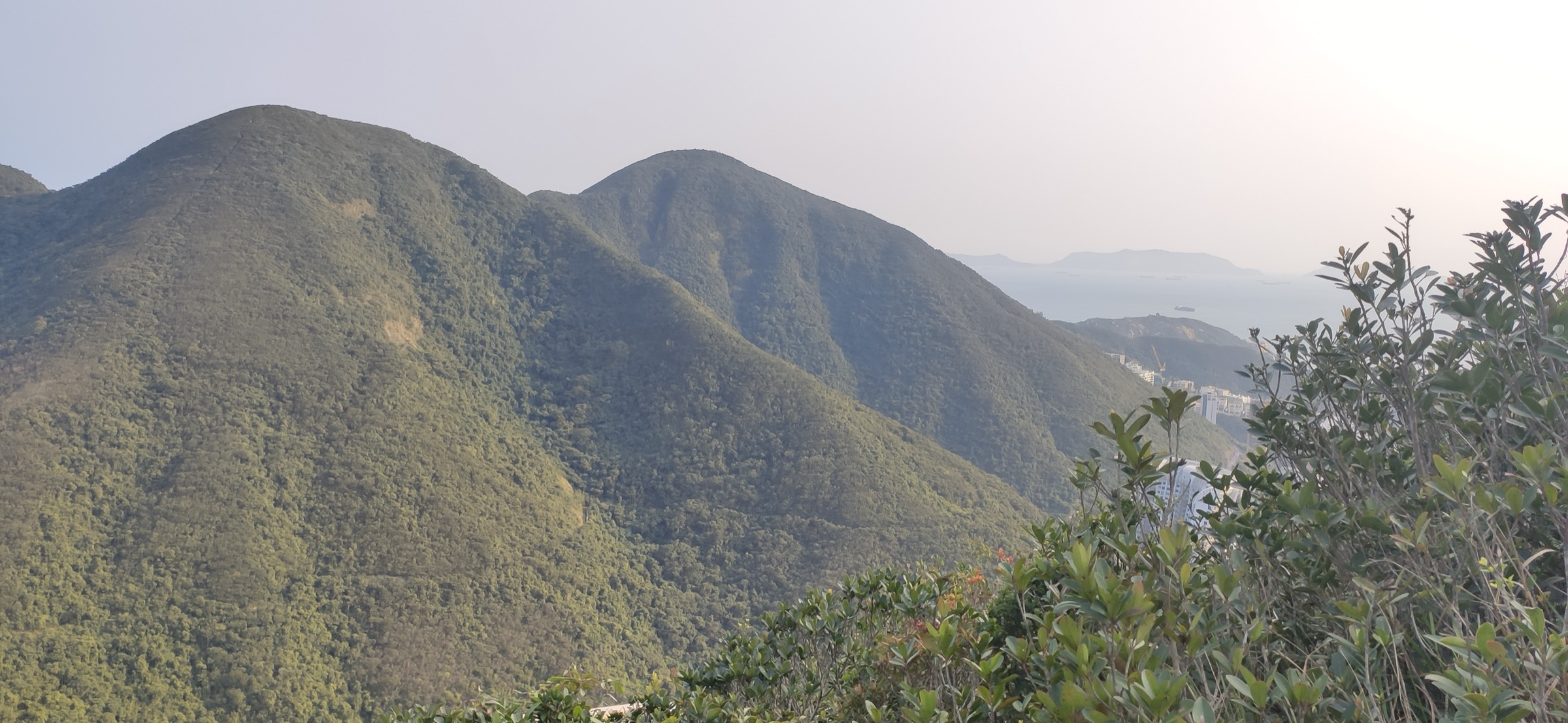
Wilson Trail Section 1 begins at the Wong Nai Chung Reservoir car park at roughly 175 m, climbs steeply south on a stair-stack through low scrub to the rounded summit of Violet Hill (433 m) with a triangulation pillar and panoramic views over Repulse Bay, Tai Tam Harbour and Mount Cameron. The trail then drops sharply to the Tsin Shui Wan Au pass at about 175 m, where a side trail descends west to Repulse Bay. The Wilson Trail itself climbs the Northern Twin (363 m), drops to a narrow saddle, climbs the Southern Twin (386 m), and then descends a famously long flight of more than a thousand granite steps down to Stanley Gap Road above Tai Tam. The Twin Peaks staircase is the route’s defining feature and the main reason the section is rated harder than its modest distance suggests.
Why it is essential
Violet Hill and The Twins is the hardest mainstream day-hike on Hong Kong Island and the classic Wilson Trail opener. The route crosses three of the highest summits on the southern ridge in less than five kilometres, gives the best ridge-top view of Repulse Bay and Stanley, and is the standard local benchmark for hill fitness ahead of longer Lantau or New Territories routes. It complements Dragon’s Back’s open coastal ridge with a steeper, stairier inland skyline.
Equipment
Sturdy trail shoes or light boots with strong grip on smoothed granite, trekking poles (strongly recommended for the descent off the Southern Twin), sun hat, at least 2-3 litres of water in warm weather, electrolytes, sun cream, and a light wind layer for the exposed ridge.
Hazards and notes
The route is essentially unshaded and includes a major net descent on hard stairs that is notoriously hard on knees. Heat exhaustion is the single largest risk in late spring and summer; AFCD warns explicitly against undertaking the route at midday in hot weather. Wet steps after rain are extremely slippery and the Southern Twin descent has caused multiple ankle injuries on the descent. Mobile coverage is generally good but battery drains fast. The route forms the first leg of the 78-km Wilson Trail, so navigation is well signposted by AFCD distance markers every 500 m.
GPX / KML links
| Source | URL |
|---|---|
| AFCD Enjoy Hiking: Wilson Trail Section 1 | hiking.gov.hk |
| Hong Kong Tourism Board: Wilson Trail (Wong Nai Chung Reservoir to Stanley Gap Road) | discoverhongkong.com |
| AllTrails: Wilson Trail Section 1 and 2 | alltrails.com |
5. Mount Parker traverse (Tai Tam to Quarry Bay over the summit)
Snapshot
Itinerary
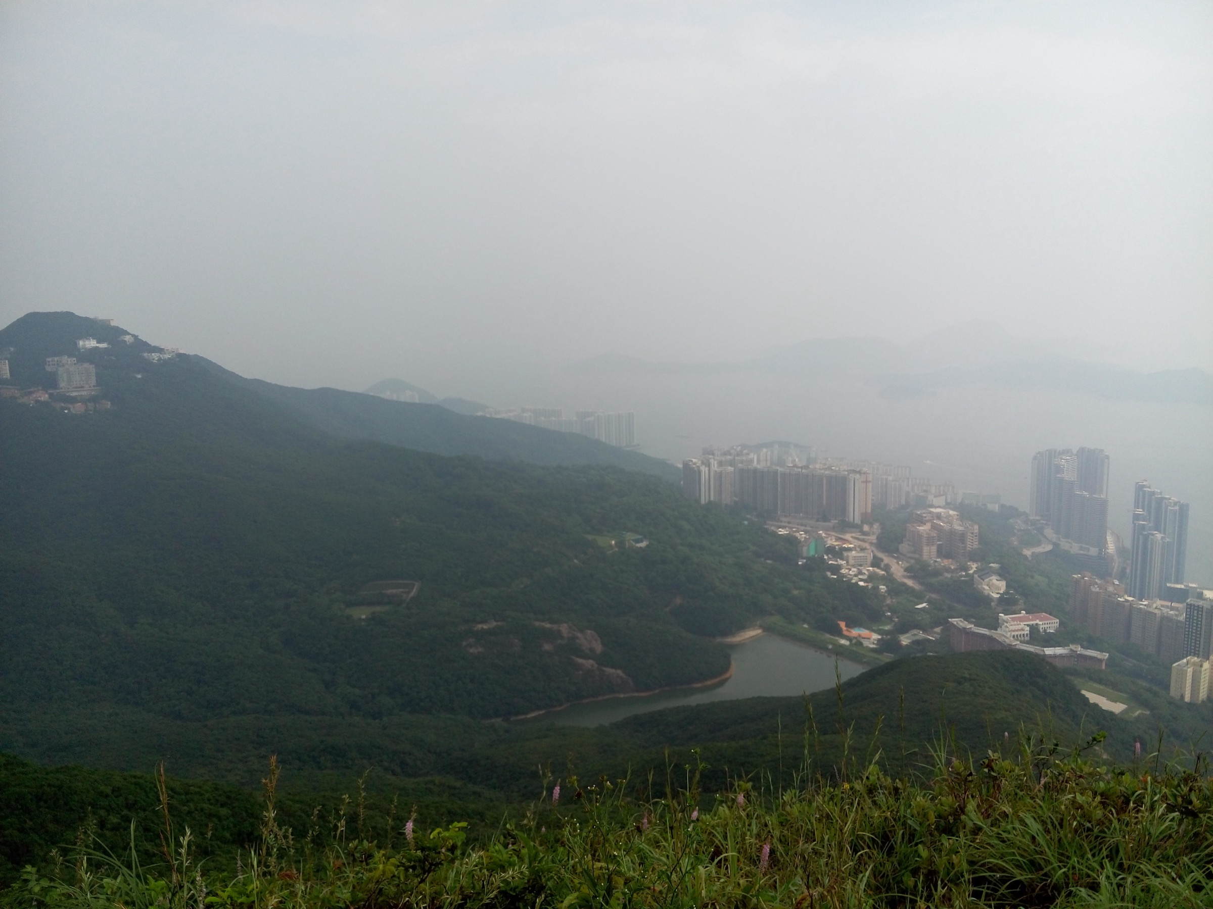
The traverse follows the Hong Kong Trail Section 6 corridor in reverse, leaving Tai Tam Reservoir Road on a wide cobbled service track that climbs steadily through the Tai Tam reservoir system. It contours above the upper reservoir with views back over Stanley and the southern ridge, then climbs north towards Quarry Gap. A signposted side trail breaks off to the summit of Mount Parker (532 m) — the second highest point of Hong Kong Island — where a flat concrete plateau hosts a weather radar station and gives a full panorama north over Kowloon, east over Junk Bay and south back along the spine to Violet Hill. From the gap the route follows the historic Mount Parker Road, a colonial-era sedan-chair road, in a long zig-zag descent through evergreen forest to Quarry Bay and the MTR.
Why it is essential
Mount Parker is the second-highest summit on the island and the natural eastern counterpart to Victoria Peak. The traverse links the granite-arch dams of the Tai Tam reservoirs — designated a national-grade heritage site — with the colonial Mount Parker Road and the urban edge of Quarry Bay, and gives the cleanest end-to-end “city-to-summit-to-city” walk on Hong Kong Island. It complements the southern ridge of Violet Hill and The Twins and the western Hong Kong Trail Section 1 by covering the eastern country park.
Equipment
Standard hiking shoes (the route is mostly hard surfaces), sun protection, water, snacks, and a light shell. Trekking poles help on the long downhill on Mount Parker Road. A torch is useful in winter when daylight ends before 18:00.
Hazards and notes
The lower Tai Tam reservoir bridges are popular with weekend traffic and can be busy. The summit detour to Mount Parker passes telecommunications and weather installations — keep to the marked path. The descent on hard tarmac is long and tough on knees; many walkers shorten the route by descending from Quarry Gap via the woodland tracks instead. Trails close during typhoon signal 8 and Black Rainstorm warnings; AFCD posts updates online.
GPX / KML links
| Source | URL |
|---|---|
| AFCD Enjoy Hiking: Hong Kong Trail Section 6 (Mount Parker Road to Tai Tam Road) | hiking.gov.hk |
| AllTrails: Mount Parker - Tseng Kwan Shek loop | alltrails.com |
| AllTrails: Parkview to Quarry Bay over Mount Parker | alltrails.com |
| MyTrail.Run: Hong Kong Trail Section 6 | mytrail.run |
External links
| Source | URL |
|---|---|
| AFCD — Enjoy Hiking portal (official trail maps and updates) | hiking.gov.hk |
| AFCD — Country and marine parks (Hong Kong Island) | afcd.gov.hk |
| Hong Kong Tourism Board — Dragon’s Back | discoverhongkong.com |
| Hong Kong Tourism Board — Peak Circle Walk | discoverhongkong.com |
| Hong Kong Tourism Board — Wilson Trail Section 1 | discoverhongkong.com |
| Round Island Trail Hong Kong — official route portal | roundislandtrail.gov.hk |
| Wikipedia — Hong Kong Trail | en.wikipedia.org |
| Wikipedia — Dragon’s Back | en.wikipedia.org |
| Wikipedia — Victoria Peak | en.wikipedia.org |
| Wikipedia — Lugard Road | en.wikipedia.org |
| Wikipedia — Pok Fu Lam Reservoir | en.wikipedia.org |
| Wikipedia — The Twins, Hong Kong | en.wikipedia.org |
| Wikipedia — Mount Parker (Hong Kong) | en.wikipedia.org |
| Wikipedia — Tai Tam Country Park | en.wikipedia.org |
| Wikipedia — Wilson Trail | en.wikipedia.org |
| AllTrails — Hong Kong Trail Section 8 (Dragon’s Back) | alltrails.com |
| AllTrails — Hong Kong Trail Section 1 | alltrails.com |
| AllTrails — Victoria Peak Loop | alltrails.com |
| AllTrails — Wilson Trail Section 1 and 2 | alltrails.com |
| AllTrails — Mount Parker (Tseng Kwan Shek) loop | alltrails.com |
| AllTrails — Parkview to Quarry Bay | alltrails.com |
| Hiking Trail HK — Hong Kong Trail Section 8 | hikingtrailhk.appspot.com |
| MyTrail.Run — Hong Kong Trail Section 6 | mytrail.run |
| Wikimedia Commons — Dragon’s Back category | commons.wikimedia.org |
| Wikimedia Commons — Victoria Peak category | commons.wikimedia.org |
| Wikimedia Commons — Tai Tam Country Park category | commons.wikimedia.org |