Regional overview
The Thompson / Shuswap Highlands sit on the eastern fringe of the Interior Plateau of British Columbia, where the Bonaparte and Thompson plateaus meet the dissected uplands of the Shuswap Highland and the western foothills of the Monashees rise behind Sicamous and Salmon Arm. The Shuswap Highland alone covers roughly 14,500 km² between the Cariboo Plateau and the Okanagan, broken up by the valleys of the Clearwater, North Thompson and Adams rivers and by the long fjord-like arms of Shuswap Lake. Elevations span from about 360 m on the Thompson River at Kamloops to a little over 2,380 m on the highest summits. The hiking character is distinctively dual: hot, semi-arid bunchgrass and sagebrush grasslands with ponderosa pine and hoodoo badlands on the Kamloops side, and cooler, wetter interior cedar–hemlock and Engelmann-spruce / subalpine-fir forests in the Shuswap and on the Sun Peaks–Tod Mountain massif to the north.
The principal hiking centres are Kamloops (and Lac du Bois Grasslands Protected Area immediately to the north), Sun Peaks Resort on Tod Mountain in the lower North Thompson, the Adams River corridor at Tsútswecw (formerly Roderick Haig-Brown) Provincial Park, and Herald Provincial Park / Reinecker Creek on the south shore of Shuswap Lake. Most of the iconic hikes are short — typically 5–15 km return — but the contrast between routes is unusually wide: a single weekend can combine grassland-ridge walking with views over Kamloops Lake, an above-treeline alpine summit reached partly by chairlift, an old-growth canyon-and-waterfall loop, and a riparian salmon-spawning circuit.
The hiking season is correspondingly broad. The Lac du Bois grasslands and lower Adams River trails are typically walkable from late March or early April through November; the Reinecker Creek / Margaret Falls trails are usually snow-free from late April to October; alpine routes on Tod Mountain are most reliable from mid-July to mid-September, with the Sunburst Express chairlift operating in 2026 from 13 June to 27 September. Heat is a real concern in the Kamloops grasslands from late June through August, with afternoon temperatures regularly above 35 °C and little shade. Rattlesnakes, ticks and prickly-pear cactus are routine grassland hazards. Black bears are common throughout the Shuswap and on Tod Mountain; grizzlies are present but uncommon at lower elevations; cougars are reported across the region. Several Shuswap parks were affected by the 2023 Bush Creek East / Lower East Adams Lake wildfires and by post-fire trail repairs at Tsútswecw in 2024–2026; current park bulletins should be checked before travel.
Access is overwhelmingly by private vehicle. Kamloops is served by VIA Rail (the Canadian) and BC Transit city buses (which do not reach trailheads), and Sun Peaks operates a paid resort shuttle from Kamloops. There is no scheduled public transport to Herald PP, Tsútswecw PP, or the Lac du Bois trailheads. BC Parks day-use is free at all of the parks listed below; Sun Peaks requires a sightseeing or hiking lift pass for chairlift-assisted hikes.
Selection rationale
Five hikes were selected to give a balanced cross-section of the region’s confirmed-open day hiking and to avoid duplicating either landscape type or trailhead cluster: Battle Bluff as the iconic grassland-ridge viewpoint above Kamloops Lake; Mount Tod as the region’s standout alpine summit hike, chairlift-assisted, with a cirque tarn and a 360-degree panorama; Margaret Falls and the Upper Canyon Loop as the most-walked Shuswap-shore route and the strongest “valley and gorge” representative; the Adams River loop at Tsútswecw as the culturally and ecologically essential walk of the Shuswap, anchoring the Salute to the Sockeye salmon run; and the Dewdrop Range Trail as a long balcony route along the bunchgrass benches above Kamloops Lake, the regional complement to Battle Bluff. Cinnamon Ridge, the Reinecker Creek long loop and the Tsútswecw Flume Trail are strong alternates for future inclusion.
Summary table
| # | Hike | Sub-region | Route type | Distance | Gain | Max elevation | Difficulty |
|---|---|---|---|---|---|---|---|
| 1 | Battle Bluff | Lac du Bois Grasslands PA | Out-and-back | 4.7 km | 265 m | 755 m | Moderate |
| 2 | Mount Tod via Sunburst and Tod Lake loop | Sun Peaks / Tod Mountain | Lift-assisted loop | 9–11 km | 600–900 m | 2,152 m | Moderate–Difficult |
| 3 | Margaret Falls and Upper Canyon Loop | Herald Provincial Park | Lollipop | 5.3–5.5 km | 230 m | 580 m | Easy–Moderate |
| 4 | Adams River loop (Cottonwood–Island Loop–Plaque Channel) | Tsútswecw Provincial Park | Loop | 6–7 km | 50 m | 370 m | Easy |
| 5 | Dewdrop Range Trail | Lac du Bois Grasslands PA | Out-and-back | 15.3 km | 885 m | 880 m | Strenuous |
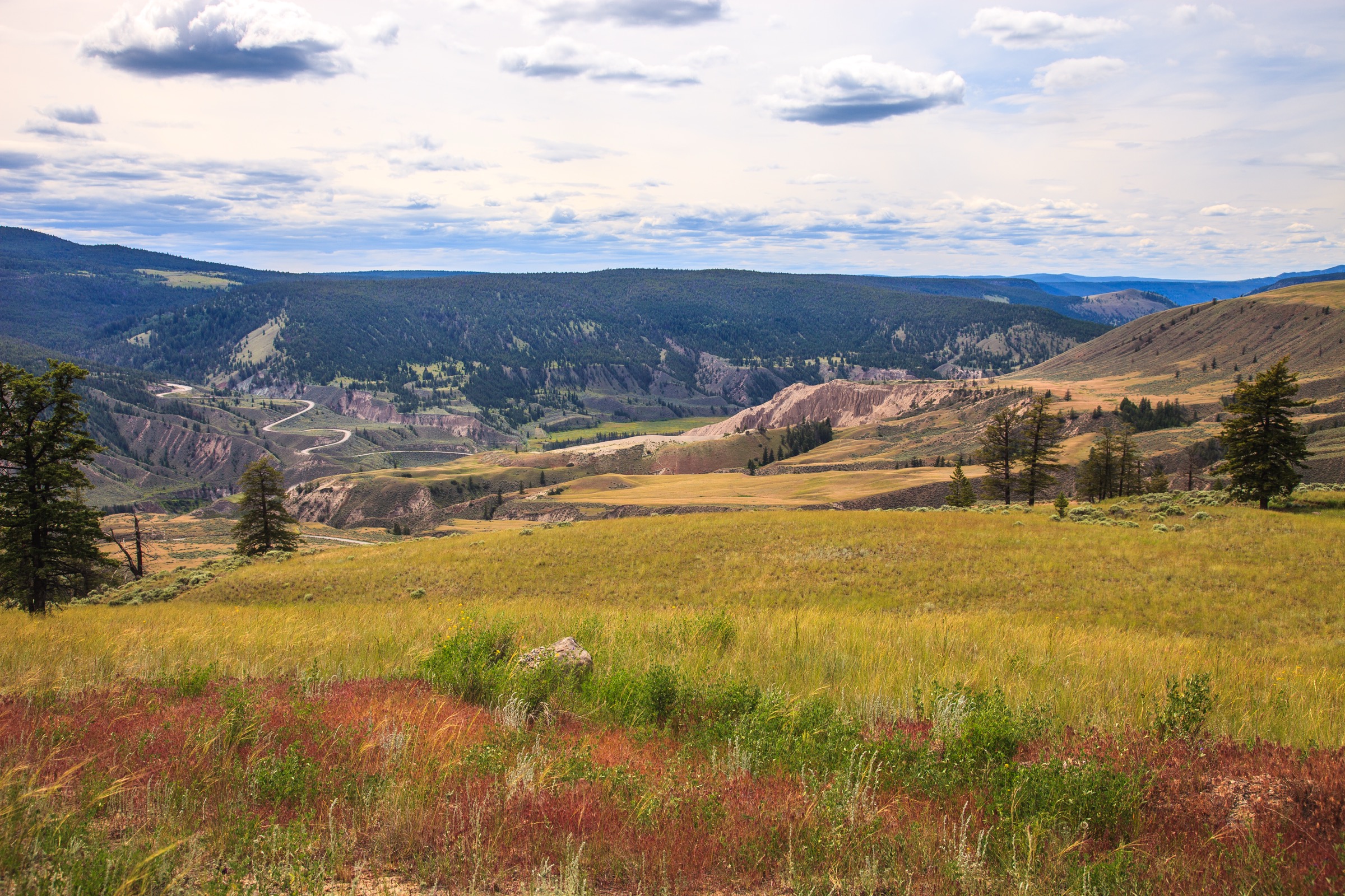
1. Battle Bluff
Snapshot
Itinerary
From the Frederick Road pull-out, approximately 1.5 km past the Red Lake Road switchbacks on the left, the trail begins on a flat grassland bench and curves westward toward the rim above Kamloops Lake. The path crosses a shallow draw, then climbs steadily on a bare, eroded grassland tread of fine silt and loose sandstone — slippery in both directions, particularly when dry. A short, steeper pitch through bunchgrass and scattered ponderosa pine leads onto the broad ridge crest. The trail follows the rim south-west, with the cliff edge falling away in stepped sandstone bluffs to the lake some 400 m below.
The summit cairn and a small memorial plaque are reached at roughly 2.3 km from the trailhead, on a broad rounded high point above the east shore of Kamloops Lake. The view extends south-west down the full 28 km length of the lake, north over the Tranquille River delta to the Lac du Bois grasslands, and east to the city of Kamloops at the confluence of the North and South Thompson rivers. Return is by the same route; the descent on the silt-and-cobble tread is the main difficulty.
Why it is essential
Battle Bluff is the prototypical Kamloops grasslands hike: a short, high-relief climb to a bunchgrass-and-sage rim above one of the largest lakes on the Thompson River. It is also one of the most culturally significant viewpoints in the Secwépemc heartland. The bluff (Secwepemctsín: Quq’wellqín) was historically used as a Secwépemc lookout for incursions across the lake and from the mountains, and as a site for vision quests; the English name commemorates a battle on the grassy plain below recorded by the photographer Benjamin Baltzly in 1871. Pictographs in red ochre exist on the lower cliff faces and are reachable only from the water.
Equipment
Standard hiking equipment plus sturdy boots with grippy soles (the silt tread is notoriously slippery on descent), trekking poles strongly recommended for the descent, sun hat and sun protection, at least 1.5 litres of water (no on-route water), and tick-aware clothing. No bear-resistant food storage normally required; carry bear spray as a precaution. Avoid in extreme heat.
Hazards and notes
The Lac du Bois grasslands are core habitat for the western rattlesnake (Crotalus oreganus); stay on the trail and watch foot placement on rock outcrops. Prickly-pear cactus and ticks are routine, and a body check after the hike is sensible. Cliff edges along the summit ridge are unfenced sandstone with crumbling lips — do not approach. The Frederick Road parking area is open and unsecured; do not leave valuables in vehicles. Dogs are permitted on-leash. No park-issued day-use fee.
GPX / KML links
| Source | URL |
|---|---|
| Trailforks: Battle Bluff | trailforks.com |
| AllTrails: Battle Bluff Trail | alltrails.com |
| OpenStreetMap: Battle Bluff trailhead area | openstreetmap.org |
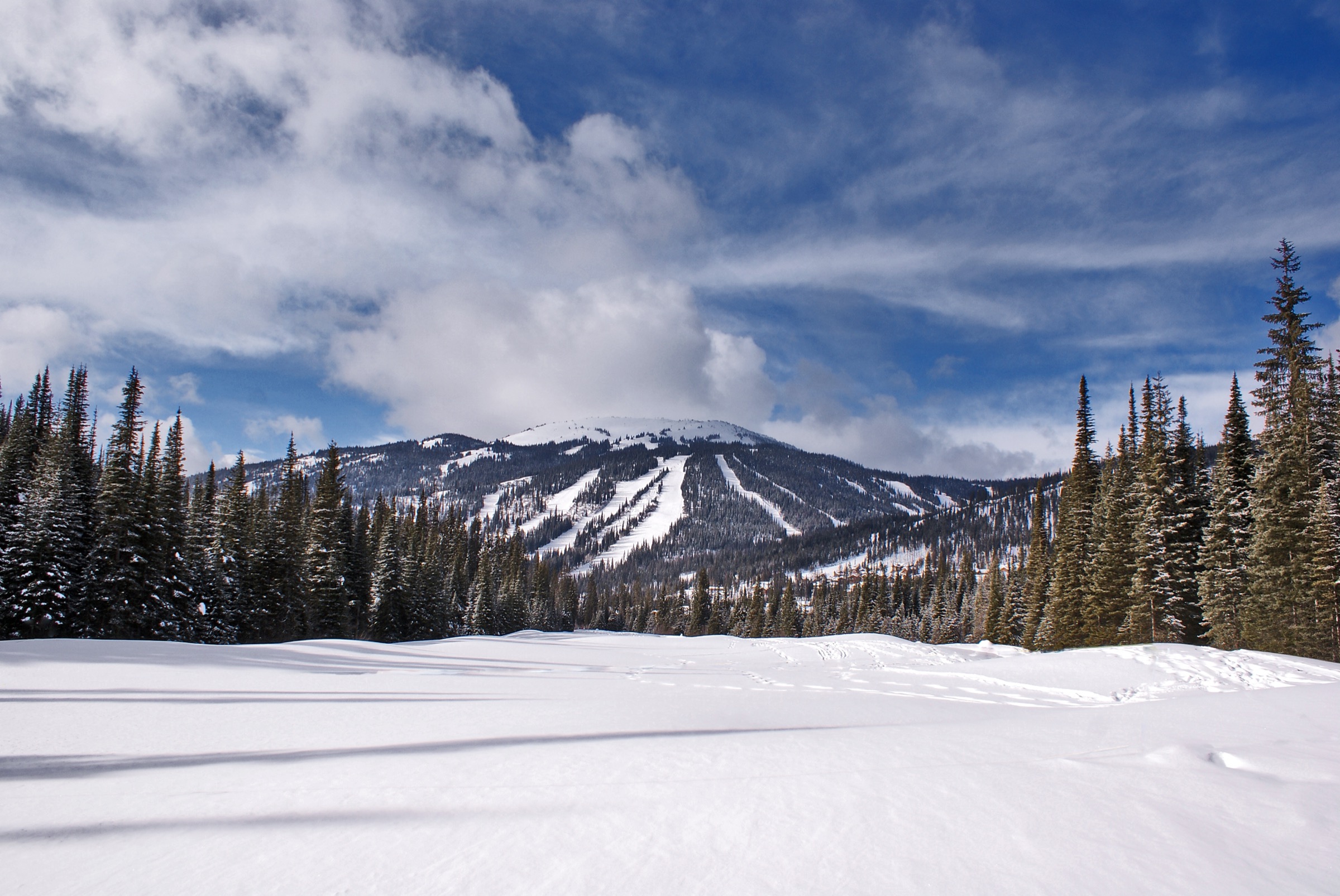
2. Mount Tod via Sunburst Express and Tod Lake loop
Snapshot
Itinerary
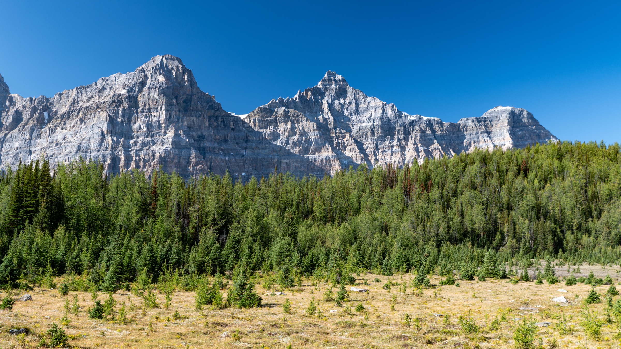
From Sun Peaks village (1,255 m), the Sunburst Express chairlift carries hikers to its top station at approximately 1,850 m on the south flank of Tod Mountain. A signed trail network leaves the upper terminal: the recommended summit route follows the Top of the World / Altitude trail north-west, climbing on a wide service track through open subalpine meadows beneath the resort’s upper ski runs. Above 2,000 m the route enters true alpine — krummholz of subalpine fir, scattered larch and extensive mid-summer wildflower meadows of Indian paintbrush, arnica, valerian and mountain heather — with views opening south and west across the Thompson Plateau toward the Trophy Mountains. The final 200 m of gain is on a stony tundra path to the summit of Mount Tod at 2,152 m, where a 360-degree panorama takes in the Bonaparte and Shuswap highlands, the southern Cariboo Mountains on the far horizon, and the entire lower North Thompson valley.
From the summit, the loop descends north-east on a marked alpine path to Tod Lake at approximately 2,000 m, a small subalpine tarn cupped on the col below Mount Morrisey. The trail then traces a sustained traverse back to the top of the Sunburst chair through the gladed sections known to skiers as Gil’s. Strong walkers can continue downhill on the West Bowl or Holy Cow trails to descend to the village on foot, adding roughly 3 km and 350 m of descent.
Why it is essential
Mount Tod is the only true above-treeline summit hike in the Thompson / Shuswap Highlands, and the chairlift assist makes the entire summit ridge accessible to walkers who would otherwise be excluded from such elevations. The combination of a defined high point at 2,152 m, a subalpine tarn, late-July wildflower meadows of regional renown, and panoramic views over both the Interior Plateau and the western foothills of the Monashees makes it the signature alpine day on this catalogue.
Equipment
Mountain hiking equipment: sturdy boots, weatherproof shell, extra warm layer (the summit ridge is exposed and ten or more degrees cooler than the village), hat and gloves outside high summer, sun protection (alpine UV at this latitude and altitude is intense), at least 2 litres of water (no reliable on-route water above the lift), trekking poles for the descent, map and GPS. A Sun Peaks sightseeing or hiking lift pass is required. Carry bear spray — black bears are routinely sighted on the lower mountain trails.
Hazards and notes
The summit ridge is fully exposed to weather; afternoon thunderstorms develop quickly over the Bonaparte Plateau and lightning is a real concern — turn around at treeline if storms approach. Snow patches commonly linger in north-facing gullies into early July. Mountain-bike traffic is heavy on some shared service tracks; walkers must yield and stay alert on blind corners. The last upload of the Sunburst chair is normally 16:30 (16:00 in shoulder season) — missing it commits hikers to a 700 m descent on foot. Dogs are permitted on-leash on the resort summer trail network. Cell coverage on the summit is patchy.
GPX / KML links
| Source | URL |
|---|---|
| AllTrails: Mount Tod via Altitude Trail | alltrails.com |
| Trailforks: Tod Peak Trail | trailforks.com |
| 10Adventures: Sun Peaks Loop / Tod Lake | 10adventures.com |
| OpenStreetMap: Sun Peaks trail network | openstreetmap.org |
3. Margaret Falls and Upper Canyon Loop
Snapshot
Itinerary
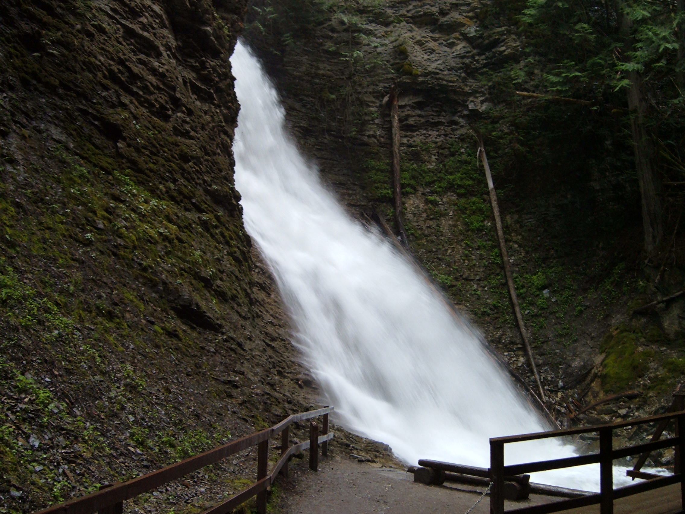
From the Reinecker Creek parking area in the day-use core of Herald Provincial Park, the well-signed lower nature trail crosses a series of footbridges into the moss-draped, old-growth interior cedar–hemlock canyon of Reinecker Creek. The first 500 m climb gently to a fenced viewing platform directly opposite Margaret Falls, a 30 m horsetail falling in a single drop into a narrow rockslot. The trail surface to the platform is hard-packed gravel and largely wheelchair-accessible; the return to the junction adds another 500 m.
For the upper canyon loop, the route continues uphill on the west side of the creek, climbing on doubletrack through cedar–hemlock and scattered Douglas-fir, with brief gaps in the canopy giving views back south over Shuswap Lake and the Tappen valley. A bridge at the top of the loop crosses Reinecker Creek where the trail intersects the wider Reinecker Creek Trail System, which continues into the Forest Service land above the park. The loop turns east, becomes singletrack, and traverses the drier east bench above the canyon, with several elevated viewpoints over the gorge and over the lake. The descent rejoins the nature trail near the lower campground, closing the loop.
Why it is essential
Margaret Falls is the most-walked single feature on the Shuswap Lake shore and the best surviving example of low-elevation old-growth interior cedar–hemlock rainforest within a BC Parks day-use area in this region. The upper canyon loop turns what would otherwise be a 30-minute waterfall stroll into a respectable short day with genuine viewpoint variety, and links into the wider Reinecker Creek trail system for those wanting a longer outing.
Equipment
Standard hiking equipment: hiking shoes or light boots (the canyon trail is regularly wet and root-laced), light waterproof, water, sun protection, insect repellent (the canyon holds mosquitoes into July). Bear spray sensible — the park is in active black-bear habitat and bears have been radio-collared in the Reinecker Creek drainage. Microspikes occasionally useful in March or November.
Hazards and notes
The fenced viewing platform is the limit of safe approach — the rocks above the plunge pool are steeply undercut, polished and lethal when wet, and there have been fatalities. Do not climb the canyon walls. Dogs are restricted: leashed dogs are allowed only in a small designated area near the Reinecker campground, and are prohibited on most trails for wildlife reasons. Black bears and cougars are present; carry bear spray and travel in groups in shoulder season. The lower nature trail and falls platform may be closed for short periods after windstorms because of windfall risk through the old-growth canopy. No park-issued day-use fee.
GPX / KML links
| Source | URL |
|---|---|
| Trailforks: Margaret Falls Upper East Trail | trailforks.com |
| Trailforks: Margaret Falls Upper West Trail | trailforks.com |
| AllTrails: Margaret Falls Upper Loop | alltrails.com |
| OpenStreetMap: Reinecker Creek canyon and upper loop | openstreetmap.org |
4. Adams River loop (Cottonwood–Island Loop–Plaque Channel)
Snapshot
Itinerary
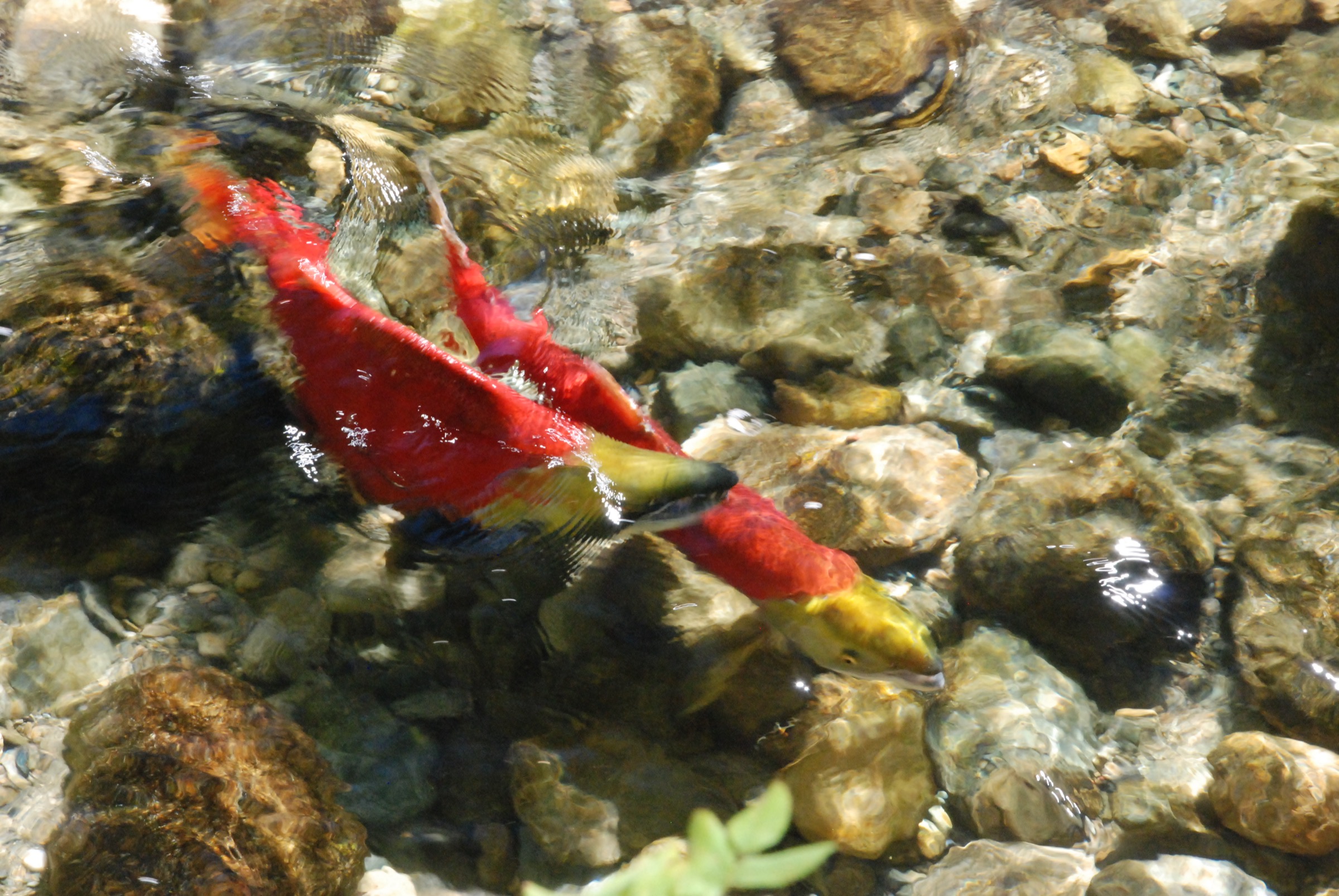
From the main day-use parking area, the Plaque Channel viewing platform trail leads roughly 300 m west to the principal salmon-viewing platform on a backwater channel of the Adams River — a low wooden deck overlooking gravel spawning beds that fill with sockeye in October. The route continues onto the Island Loop trail, a flat 1.5 km circuit around a small island in the river that BC Parks describes as the most appealing of the park’s salmon-viewing locations. The loop returns to the channel near the main day-use plaza.
From the plaza, the Cottonwoods Trail runs east along the south bank of the Adams River through tall black-cottonwood and trembling-aspen gallery forest, crossing seasonal side-channels and passing a series of interpretive panels. After approximately 3.5 km the trail reaches the mouth of the Adams River on Little Shuswap Lake, where the salmon enter the river and where most of the post-spawning carcasses accumulate. Return is via the same trail; walkers wanting a shorter outing can turn back at any of several intermediate beaches.
The post-2023 wildfire rebuild reopened the Viewing Platform, Island Loop and Plaque Channel trails in May 2026 in time for the 2026 Salute to the Sockeye dominant run; the Wade Road, Flume, Packer and Adams trails on the upper river remain partially closed or unmaintained pending further restoration.
Why it is essential
The Adams River is the single most important sockeye salmon spawning system in the Fraser drainage and one of the largest in North America. The 2026 run is a dominant-year cycle (Salute to the Sockeye festival 30 September – 23 October 2026), with millions of fish expected. The river is also Secwépemc cultural heartland: the 1977 provincial archaeological survey identified 66 habitation sites along the lower river dating back to 2000 BCE, and the people of the Adams River area — the Sxste’lln, now the Adams Lake Indian Band — are a sub-group of the Secwépemc Nation. The park itself was renamed from Roderick Haig-Brown to Tsútswecw (“many waters” in Secwepemctsín) in 2018 at the request of the Little Shuswap Lake Band.
Equipment
Standard hiking equipment: light boots or trail shoes, weatherproof layer (the river corridor is wet and cool in October), warm layer for autumn viewing, water, sun protection, binoculars for salmon-viewing. Bear spray sensible — black bears actively feed on salmon carcasses in October and are routinely seen on the trails during the run. Insect repellent in early summer.
Hazards and notes
During the October run, parking and trail congestion is intense; arrive early and consider a weekday visit. Bears (mostly black, occasionally grizzly) actively feed on salmon along the trails — give all bears wide space and never approach a feeding animal. Dogs must be on-leash and are restricted from designated salmon-viewing platforms and from much of the riverbank during the run. Park entry is free; special-event parking fees may apply during Salute to the Sockeye. Several upper-park trails (Wade Road, Flume, Packer, Adams) remain closed or unmaintained following the 2023 Bush Creek East fire damage — confirm current status on the BC Parks page before extending the route.
GPX / KML links
| Source | URL |
|---|---|
| AllTrails: Roderick Haig-Brown Loop | alltrails.com |
| Trailforks: Tsútswecw / Roderick Haig-Brown region | trailforks.com |
| BC Parks: Tsútswecw trail map (PDF) | nrs.objectstore.gov.bc.ca |
| OpenStreetMap: lower Tsútswecw / Adams River paths | openstreetmap.org |
5. Dewdrop Range Trail
Snapshot
Itinerary
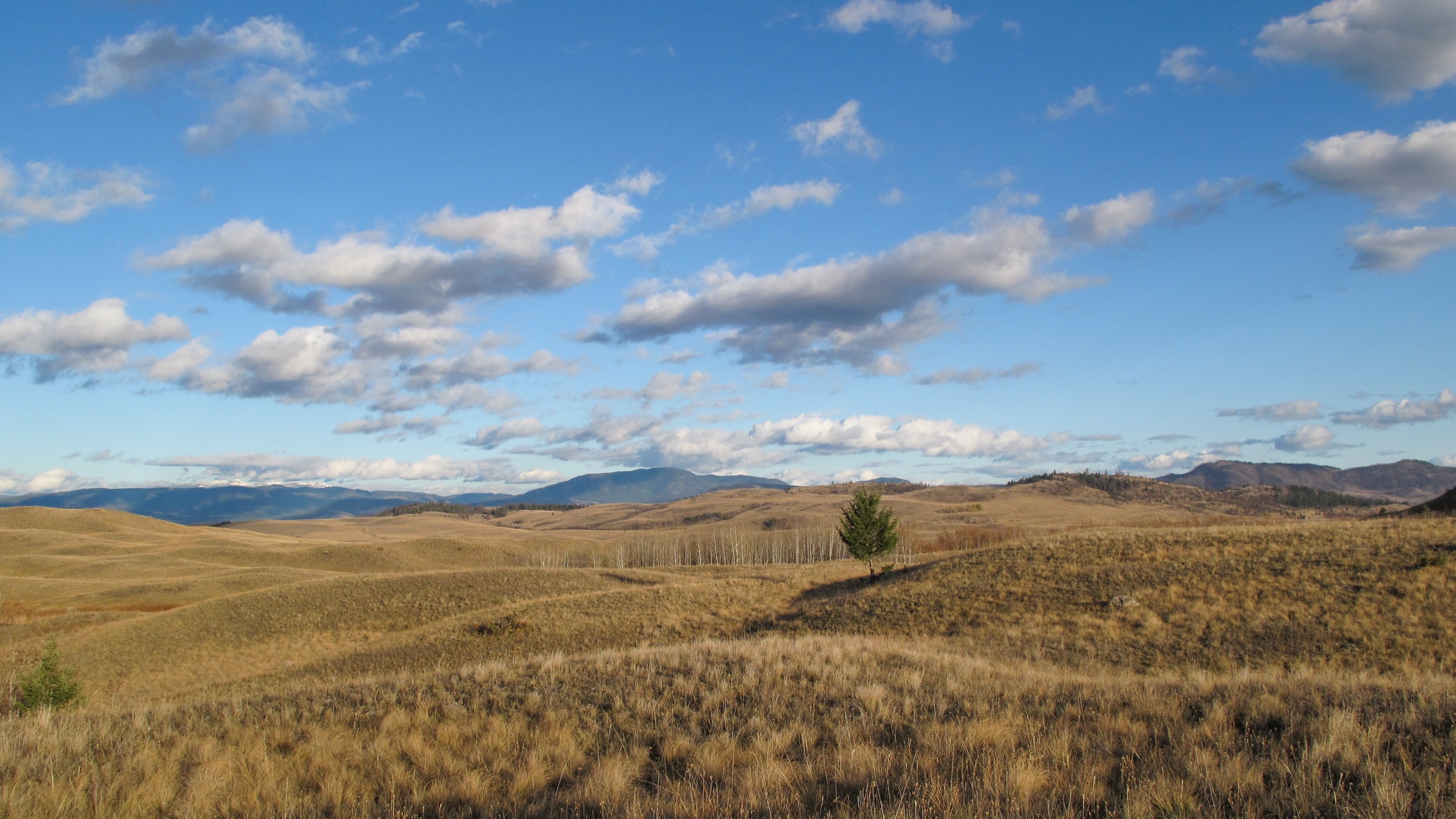
From the Frederick Road trailhead the route initially shares ground with the start of the Battle Bluff approach, then branches west along the Dewdrop Range — the long bunchgrass and ponderosa-pine bench that forms the north rim of Kamloops Lake. The trail climbs in a series of rolling steps through open grassland, dropping into and out of several shallow gullies that drain north into the Tranquille River. Cattle trails braid the route in places; the official tread is the better-defined of the parallel paths and is marked intermittently with small wooden posts.
Beyond the first major draw the trail traverses a sustained sequence of bunchgrass benches with continuous views south over Kamloops Lake to the Greenstone Mountain and Skitchine plateaus on the south shore. Wildflowers — arrow-leaved balsamroot, brown-eyed Susan, mariposa lily, prairie crocus — are at their best from mid-April to early June. The high point of the marked route is reached on the broad upper Dewdrop ridge at approximately 880 m, with sweeping views west toward the Tranquille River canyon and the start of the Thompson Valley narrows. Return is by the same route.
Why it is essential
The Dewdrop Range Trail is the regional balcony walk — a sustained ridge and bench traverse through one of the largest continuous tracts of intact northern bunchgrass grassland in Canada, with almost uninterrupted views over Kamloops Lake. Where Battle Bluff is a short, sharp viewpoint, Dewdrop is a true mid-distance walking line through grassland habitat, and consistently appears on regional shortlists alongside Battle Bluff and Cinnamon Ridge as one of the defining Lac du Bois experiences.
Equipment
Standard hiking equipment plus sturdy boots with good grip on dry silt, trekking poles strongly recommended, sun hat and high-SPF sun protection (there is essentially no shade for the length of the route), at least 3 litres of water (no reliable on-route water), and tick-aware clothing. Carry bear spray. Microspikes useful in shoulder season for icy descents on north-facing pitches.
Hazards and notes
Western rattlesnakes are common; stay on the trail and watch foot placement around rock outcrops and shrub bases. Heat exhaustion is the principal mid-summer risk and walkers should not attempt the full route on days with forecast highs above ~30 °C. Cattle are present on the protected area and may block the trail; do not approach. Prickly-pear cactus and ticks are routine. Cougar and bear sightings are infrequent but documented. Dogs permitted on-leash. The area is open all year and outside any seasonal closure.
GPX / KML links
| Source | URL |
|---|---|
| AllTrails: Dewdrop Range Trail | alltrails.com |
| Trailforks: Dewdrop and Tranquille region | trailforks.com |
| Hike Kamloops: Dewdrop Trail | hikekamloops.ca |
| OpenStreetMap: Dewdrop Range Trail | openstreetmap.org |
External links
| Source | URL |
|---|---|
| BC Parks — Lac du Bois Grasslands Protected Area | bcparks.ca |
| BC Parks — Herald Park | bcparks.ca |
| BC Parks — Herald Park nature trail | bcparks.ca |
| BC Parks — Tsútswecw Park | bcparks.ca |
| BC Parks — Tsútswecw trail map (PDF) | nrs.objectstore.gov.bc.ca |
| City of Kamloops — Secwépemc and Settler History | kamloops.ca |
| Sun Peaks Resort — Explore hiking | sunpeaksresort.com |
| Sun Peaks Resort — Trail map and status | sunpeaksresort.com |
| Sun Peaks Resort — Alpine sightseeing / chairlift hours | sunpeaksresort.com |
| Adams River Salmon Society — Salute to the Sockeye 2026 | salmonsociety.com |
| Adams River Salmon Society — Visitors page | salmonsociety.com |
| Tourism Kamloops — Hiking | tourismkamloops.com |
| Tourism Kamloops — Hiking Battle Bluff | tourismkamloops.com |
| Hike Kamloops | hikekamloops.ca |
| Kamloops Trails (Doug Smith) | kamloopstrails.com |
| Shuswap Trails | shuswaptrails.com |
| Shuswap Tourism — sockeye salmon run at Tsútswecw | shuswaptourism.ca |
| 10Adventures — Sun Peaks Loop / Tod Lake | 10adventures.com |
| 10Adventures — Margaret Falls Upper Loop | 10adventures.com |
| 10Adventures — Dewdrop Range Trail | 10adventures.com |
| Wikipedia — Shuswap Highland | en.wikipedia.org |
| Wikipedia — Adams River (British Columbia) | en.wikipedia.org |
| Wikipedia — Secwépemc | en.wikipedia.org |
| Wikipedia — Mount Tod | en.wikipedia.org |
| Wikimedia Commons — Lac du Bois Grasslands Protected Area | commons.wikimedia.org |
| Trailforks — Dewdrop and Tranquille | trailforks.com |
| AllTrails — Kamloops area trails | alltrails.com |