Regional overview
The Chilcotin Plateau is the south-western lobe of the British Columbia Interior Plateau, lying between the Fraser River on the east and the Coast Mountains on the west. Its surface — at elevations of roughly 900–1,500 m — is built from extensive Neogene basalt flows of the Chilcotin Group, blanketed by glacial drift, and dotted with shield volcanoes of the Anahim Volcanic Belt: the Rainbow, Ilgachuz and Itcha ranges, all north-west of Anahim Lake. On its western margin the plateau abuts the Pacific Ranges of the Coast Mountains; isolated outliers such as Tŝʼilʔoŝ (Mount Tatlow, 3,063 m) and the Potato Range rise abruptly from plateau-floor lakes including Chilko, Taseko and Tatlayoko. The eastern margin breaks off in a system of deep, dry canyons cut by the Chilcotin and Fraser rivers, where wind-blown silt has formed hoodoos and the largest sand dunes in British Columbia.
The plateau is the unceded territory of the Tŝilhqot’in (Chilcotin) Nation and, on its western and northern fringes, of the Ulkatcho and Nuxalk peoples. It is exceptionally lightly populated and lightly trailed. Highway 20 (the Chilcotin Highway), the only paved through-route, runs west from Williams Lake to Anahim Lake and over Heckman Pass into the Bella Coola Valley. All other access is by gravel forest service roads, many of which are rough and rutted. There is no scheduled public transport along Highway 20; a private vehicle, often high-clearance, is essential for trailhead access. Cell coverage is intermittent at best and absent on most trails. Fuel and basic services are concentrated at Hanceville, Alexis Creek, Tatla Lake, Nimpo Lake and Anahim Lake.
The standard day-hike season runs from late June or early July through mid-September. Above about 1,800 m, snow patches can linger into mid-July, and meadows can be boggy and mosquito-ridden in early summer. Afternoon convective storms are common in July and August. The plateau supports a high density of black and grizzly bears, particularly around Chilko Lake — which holds one of the densest grizzly populations in the province — and the Bella Coola/Atnarko corridor; bear spray and group travel are routinely recommended. California bighorn sheep, mountain caribou (in the Itcha-Ilgachuz herd), moose, wolves and cougars are also widespread. Some destinations carry specific Indigenous cultural protocols: BC Parks enforces Xeni Gwet’in restrictions in Ts’ilʔos Park, including a prohibition on climbing Tŝʼilʔoŝ (Mount Tatlow) itself.
Compared with the Rockies or the Selkirks, the Chilcotin Plateau is genuinely thin on maintained, signposted day hikes. Most so-called trails are unmarked routes, decommissioned roads or game traces, and many of the iconic landscapes — the Rainbow Range high alpine, the Itcha-Ilgachuz volcanic uplands, the head of Chilko Lake — are most commonly reached by horse, float plane or multi-day backpacking. The selection below reflects that reality.
Selection rationale
The region cannot honestly support a slate of five fully verified, conventional day hikes; this entry presents four well-attested options that together cover the geographic and landscape diversity of the plateau. Tullin Mountain in Ts’ilʔos Provincial Park is the only widely cited summit day hike inside the park, with the signature Chilko Lake / Coast Mountains panorama and a strong cultural context. The Rainbow Range Trail in Tweedsmuir South is the shortest legitimate alpine day hike onto an Anahim Volcanic Belt shield volcano, representing the multi-coloured peralkaline lava landscapes that define the plateau’s western edge. Farwell Canyon is the iconic short walk through the dry-canyon, hoodoo and sand-dune country at the plateau’s eastern break-off above the Fraser River. Kappan Mountain Lookout is a short, steep climb to a basalt-rim viewpoint with a panorama linking Coast Mountain peaks, the Anahim volcanoes and the cliffs above Hunlen Falls. Junction Sheep Range Park, the Hunlen Falls viewpoint and the high alpine of the Itcha-Ilgachuz are excluded because they lack marked trails, are aviation-dependent, or are multi-day backpacking objectives.
Summary table
| # | Hike | Country | Route type | Distance | Gain | Max elevation | Difficulty |
|---|---|---|---|---|---|---|---|
| 1 | Tullin Mountain | Canada | Out-and-back | 12–14 km | 730–870 m | 2,000 m | Strenuous |
| 2 | Rainbow Range Trail | Canada | Out-and-back | 14 km | 300 m | 1,830 m | Moderate |
| 3 | Farwell Canyon hoodoos and sand dunes | Canada | Loop / out-and-back | 3.4 km | 150 m | 900 m | Moderate |
| 4 | Kappan Mountain Lookout | Canada | Out-and-back | 7.2 km | 553 m | 1,920 m | Strenuous |
1. Tullin Mountain
Snapshot
Itinerary
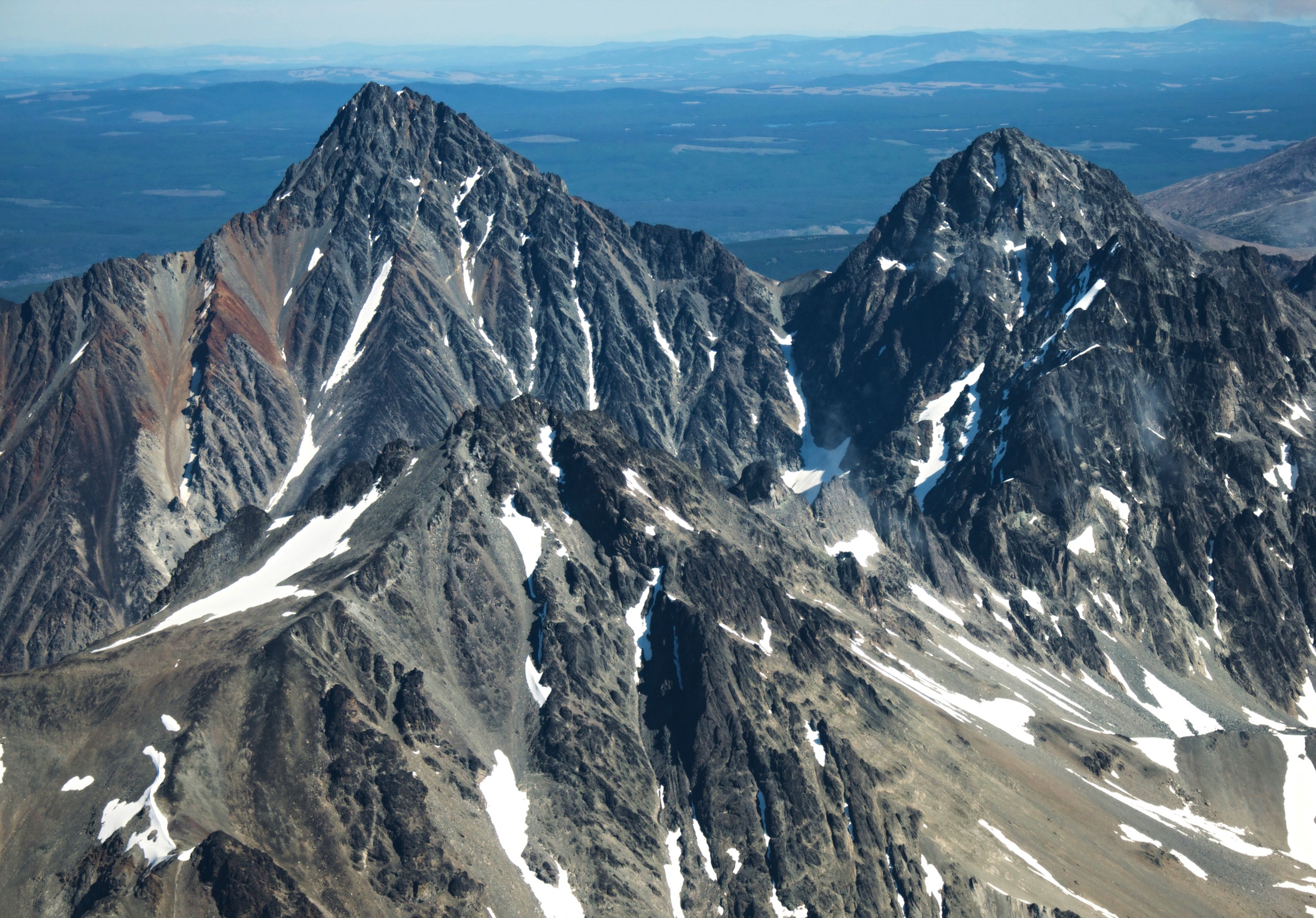
From Gwa Da Ts’ih Campground, at approximately 1,170 m on the north shore of Chilko Lake, the trail enters lodgepole pine forest on the east side of the campground and climbs steeply for the first two kilometres on a rooted, sometimes washed-out tread. The grade is sustained — the route gains the bulk of its elevation in the first 3 km — before easing onto the north-east shoulder of the mountain. Above approximately 1,600 m the trees thin into open subalpine, with the first views east over the plateau and west across Chilko Lake to the Coast Mountains.
The upper trail crosses meadow and broken rock, generally trending south-west along the broad ridge to a rocky summit cairn at roughly 2,000 m. From the summit the panorama covers the full 65 km length of Chilko Lake, the Potato Range to the south, Tŝʼilʔoŝ (Mount Tatlow, 3,063 m) to the south-east, and the eastern flank of the Niut and Pantheon ranges of the Coast Mountains. A faint trace continues approximately 8 km south along the ridge into the Potato Range for those equipped for multi-day travel. Return is by the same route; the steep lower section is the principal injury risk on descent.
Why it is essential
Tullin Mountain is effectively the only widely recognised day-summit hike inside Ts’ilʔos Provincial Park and the single most accessible alpine viewpoint over Chilko Lake — at 65 km long the largest natural freshwater lake at this elevation in Canada — and over Tŝʼilʔoŝ, which the Xeni Gwet’in regard as the founding figure of the surrounding landscape. The climb concentrates the essential Chilcotin landscape transition from interior-plateau lodgepole forest to glacier-carved Coast Mountain alpine into a single day.
Equipment
Mountain hiking equipment: sturdy boots, weatherproof shell, warm mid-layer, hat and gloves outside high summer, sun protection, at least 2 L of water (no reliable on-route water above the trailhead), trekking poles for the steep descent, map and GPS, headtorch for long days. Carry bear spray; this is high-density grizzly habitat. A satellite communicator is recommended given the remoteness and absent cell coverage.
Hazards and notes
Chilko Lake hosts one of the densest grizzly populations in British Columbia, and bear sightings on this trail are frequent — particularly in late August and September, when bears feed on returning sockeye in the Chilko River. Travel in groups, make noise, and store food appropriately at the trailhead and lake-shore campground. The trail is unsignposted above the lower forest section and route-finding through the upper subalpine becomes necessary in poor visibility. Storms develop rapidly over the lake. Access road conditions vary; the final ~50 km off Highway 20 is rough gravel and slow. BC Parks classifies Ts’ilʔos as a wilderness park with limited services; all trails are unmaintained and visitors must be experienced and self-sufficient. Xeni Gwet’in protocols prohibit climbing Tŝʼilʔoŝ itself and several other named summits; Tullin Mountain is not affected by that prohibition. Dogs are discouraged because of wildlife.
GPX / KML links
| Source | URL |
|---|---|
| Hiking Project: Tullin Mountain | hikingproject.com |
| AllTrails: Tullin Mountain | alltrails.com |
| Ramble On: Tullin Mountain Hike | rambleon.ca |
| OpenStreetMap: Tullin Mountain / Chilko Lake area | openstreetmap.org |
2. Rainbow Range Trail
Snapshot
Itinerary
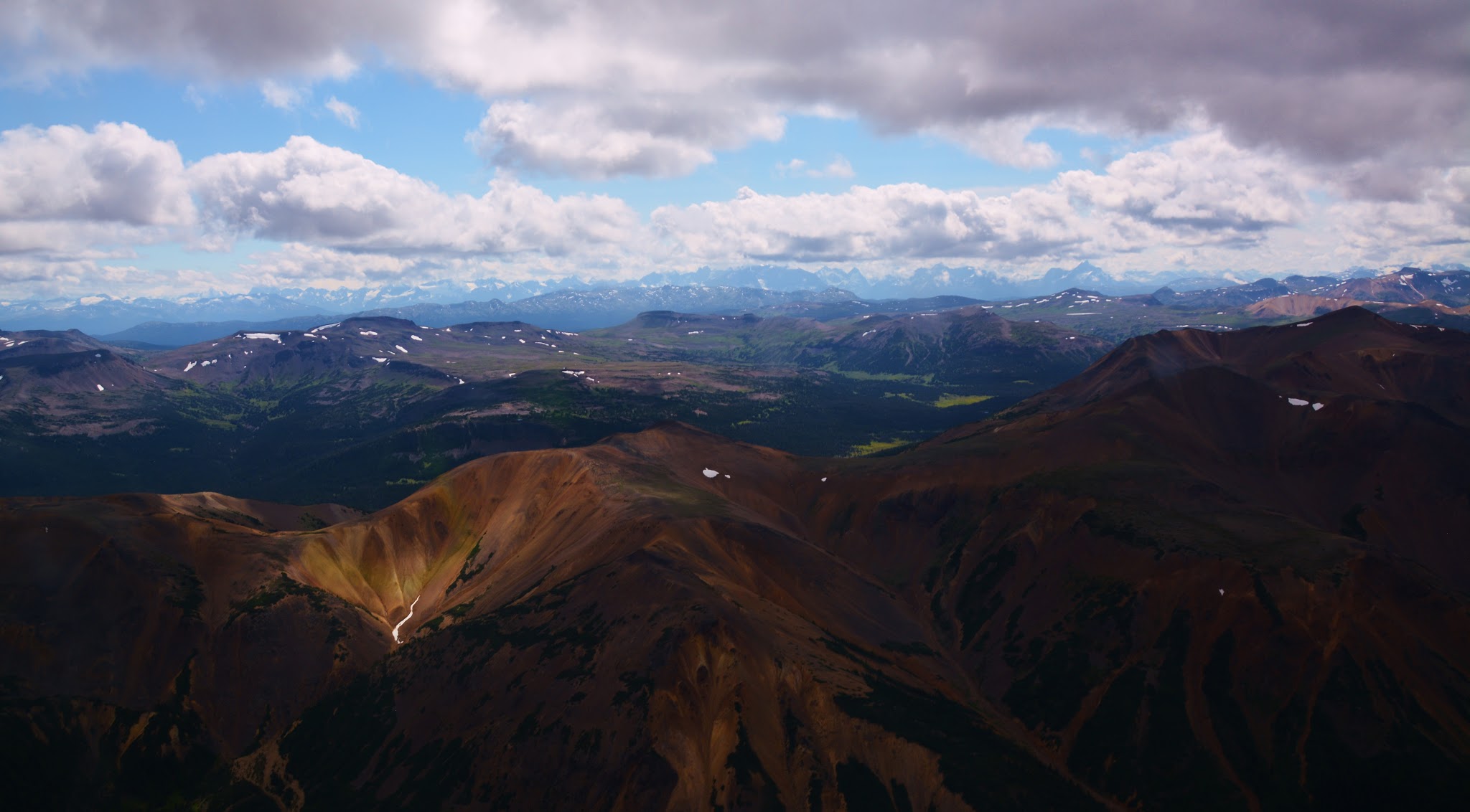
From the trailhead on the north side of Highway 20 just west of the park entrance near Heckman Pass, the trail leaves the highway through a stand of lodgepole pine and climbs gently through a mixed forest of subalpine fir and whitebark pine. The grade is consistently easy. After approximately 4–5 km the trail breaks out of the trees onto open subalpine meadows on the southern flank of the Rainbow Range, with the first view north-east into a bowl of small unnamed lakes and tarns and onto the eroded, multi-coloured volcanic ridges of the eight-million-year-old Rainbow shield volcano. The colour palette — ochres, rusts, lavenders and yellows — results from heavy mineralisation and hydrothermal alteration of the peralkaline lavas, exposed by extensive glacial erosion of the original shield.
The signposted alpine viewpoint and its small lake sit at roughly 1,830 m. Most parties turn around here. Strong walkers can continue north on the route across the alpine, eventually reaching McCauley Lake at around 9 km one-way, and from there onto the high tundra below Tsitsutl Peak (2,495 m). Return is by the same route.
Why it is essential
The Rainbow Range Trail is the shortest legitimate access onto an Anahim Volcanic Belt shield volcano and the most photographed colourscape on the Chilcotin Plateau. The Ulkatcho name Tsitsutl translates as “rainbow mountains.” For visitors driving Highway 20, this is the only realistic alpine day-hike option between Williams Lake and Bella Coola and one of the few signposted day-hike trails inside Tweedsmuir South. It is also the easiest in-region demonstration of the geological character that distinguishes the Chilcotin Plateau — post-Miocene basalts and shield volcanoes — from the granitic Coast Mountains immediately to the south-west.
Equipment
Standard mountain hiking equipment: sturdy boots, weatherproof shell, warm layer, sun protection, at least 2 L of water (limited reliable water once in the alpine), trekking poles, insect repellent (mosquitoes can be severe through July), map and GPS, headtorch for long days. Carry bear spray. A satellite communicator is recommended.
Hazards and notes
The trail is generally well-defined to the alpine viewpoint but route-finding skills are required beyond, where the route is unmarked across open subalpine meadows. BC Parks notes that trails in the southern portion of Tweedsmuir Park are not regularly maintained and may have fallen trees or wash-outs. Grizzly bears are present throughout. Mosquitoes through July can be the most aggressive in the region. Heckman Pass is the highest point on Highway 20 at 1,524 m; the highway is paved and open year-round but can be affected by winter weather and occasional summer wildfire closures. No park-issued permit is required for day use. Dogs are permitted on-leash; recommended only for experienced walkers given wildlife and grade.
GPX / KML links
| Source | URL |
|---|---|
| Wikiloc: Rainbow Range Trail | wikiloc.com |
| AllTrails: Rainbow Range Trail | alltrails.com |
| Gaia GPS: Rainbow Range Trail | gaiagps.com |
| OpenStreetMap: Rainbow Range area | openstreetmap.org |
3. Farwell Canyon hoodoos and sand dunes
Snapshot
Itinerary
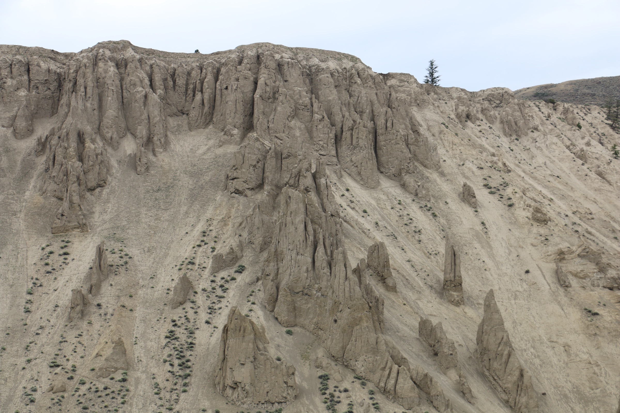
Farwell Canyon — locally also spelled Farewell — sits at the confluence of the Chilcotin and Fraser rivers, where the Chilcotin Plateau’s basalt cap drops away through hundreds of metres of silt, sand and till into a canyon system carved by post-glacial rivers. From the road bridge crossing the Chilcotin River, a one-lane wooden bridge built in 1968, two distinct short walks are possible.
The dunes loop begins on the south side of the bridge. The route climbs through open ponderosa-pine and sagebrush grassland, traverses east along the bench above the river, and drops onto the largest active sand dune system in British Columbia — an expanse of fine wind-blown silt and sand draped over the south-facing valley wall. The sand can be climbed and descended; care is needed on the steep upper face, and footing is loose. The loop returns along the bench to the bridge.
On the north side of the bridge, a separate informal trail network climbs the cliffs above the road to viewpoints over the canyon’s distinctive hoodoos — slender pinnacles formed by differential erosion of the silty cliffs above the river. These are short walks of under an hour and best done either side of the dunes loop. The whole canyon is core California-bighorn-sheep habitat, and herds of 20–50 animals are commonly seen on the cliffs and on the river bars.
Why it is essential
Farwell Canyon is the eastern Chilcotin Plateau in one short walk: dry grassland, hoodoos, basalt rim, the largest active sand dunes in British Columbia, an iconic single-lane river bridge, the densest California bighorn sheep concentration in the region, the Chilcotin/Fraser confluence and a documented archaeological landscape (the canyon contains pictographs and was a key Tŝilhqot’in salmon fishery). No other accessible day-walk in the region delivers this combination of landscape and wildlife in 1–2 hours, and it complements the alpine and plateau-summit hikes in this catalogue as the only landscape representative of the eastern canyon country.
Equipment
Standard hiking equipment with a strong emphasis on sun and heat management: lightweight footwear that can handle sand, sun hat, sun protection, at least 2 L of water even for the short loop, electrolytes recommended in hot weather. Lightweight gaiters are useful in the dunes. No technical gear required. Carry bear spray as a precaution — mainly black bear in this corridor — and be aware of rattlesnakes, which are present at this latitude on the Fraser bench.
Hazards and notes
The 2024 Chilcotin River landslide deposited a major slope failure into the river approximately 6 km upstream of Farwell Canyon and is the subject of an ongoing slope-stability programme. As of 2025–2026, Farwell Canyon Road remains open to the public and was not subject to the broader Chilcotin lower-river Crown Land closure that ran from September 2024 into early 2025; visitors should still check the latest BC Government emergency-management bulletins before travel. Cliff edges are unfenced; falls have occurred. Heat exposure is a real summer risk. The sand dunes are an active and ecologically sensitive landform — restrict movement to existing trails on the periphery; do not drive on them. Cell coverage is absent. Dogs permitted under control.
GPX / KML links
| Source | URL |
|---|---|
| AllTrails: Farwell Canyon Sand Dunes | alltrails.com |
| AllTrails: Farwell Canyon Bend | alltrails.com |
| OpenStreetMap: Farwell Canyon Road / area | openstreetmap.org |
4. Kappan Mountain Lookout
Snapshot
Itinerary
From the trailhead at approximately 1,370 m, the route immediately enters subalpine spruce-fir forest and begins a sustained climb on a narrow, rooty footpath. The grade is consistently steep — close to 16% on average, with steeper short pitches — and gains the majority of its elevation in the first 2.5 km. Trees thin into open subalpine meadow at roughly 1,700 m, where some route-finding becomes necessary; cairns and worn ground mark the line up to a sub-peak of Kappan Mountain. The lookout sits at roughly 1,920 m, on the western lip of a basalt-rim landscape characteristic of the Anahim Volcanic Belt.
From the lookout the panorama covers, clockwise from south: the eastern flanks of the Pacific Ranges of the Coast Mountains; the deep notch of the Bella Coola/Atnarko valley; the cliffs above Hunlen Falls (260 m, one of the tallest free-falling waterfalls in Canada); the multi-coloured Rainbow Range to the west; Anahim Peak (Bes But’a / Bis Nadiʔah, the “obsidian peak”) and the broader Anahim Lake basin to the north-east; and Kappan and Hotnarko lakes immediately below. Return is by the same route; the steep upper descent is the principal injury risk.
Why it is essential
Kappan Mountain Lookout is the most concise summit-and-panorama hike in the West Chilcotin and the only short day hike that links — in a single view — three of the defining landscape elements of the western Chilcotin Plateau: the Coast Mountains frontier, the Anahim Volcanic Belt (Rainbow Range and Anahim Peak), and the canyons feeding the Atnarko/Bella Coola system. It is also one of the very few short, official, signposted hikes in the region (most Chilcotin hikes are unmarked routes), administered by Recreation Sites and Trails BC.
Equipment
Mountain hiking equipment: sturdy boots, weatherproof shell, warm mid-layer, hat and gloves on the lookout, sun protection, at least 2 L water (no reliable on-route water), trekking poles strongly recommended for the descent, map and GPS, insect repellent for early-summer outings, headtorch. Carry bear spray. A satellite communicator is recommended.
Hazards and notes
The trail is steep, eroded in places, and requires moderate route-finding in the upper meadows. Sites and Trails BC explicitly classes the trail as recommended only for those with backcountry hiking experience. The upper terrain is exposed to weather and lightning. The access roads from Highway 20 are unsealed forest service and industrial roads — checked at each junction (Kappan Mountain Road, Beeftrail Road, Hotnarko Road) — and are not signposted to tourist standards. Cell coverage is absent. Grizzly bear habitat. Dogs are permitted; off-leash discouraged due to wildlife.
GPX / KML links
| Source | URL |
|---|---|
| Sites and Trails BC: Kappan Mountain Lookout Trail (REC230054) | sitesandtrailsbc.ca |
| Gaia GPS: Kappan Mountain Lookout Trail | gaiagps.com |
| OpenStreetMap: Kappan Mountain / Anahim Lake area | openstreetmap.org |
External links
| Source | URL |
|---|---|
| BC Parks — Ts’ilʔos Park | bcparks.ca |
| BC Parks — Tweedsmuir Park | bcparks.ca |
| BC Parks — Tweedsmuir South hiking | bcparks.ca |
| BC Parks — Itcha Ilgachuz Park | bcparks.ca |
| BC Parks — Junction Sheep Range Park | bcparks.ca |
| Recreation Sites and Trails BC — Kappan Mountain Lookout (REC230054) | sitesandtrailsbc.ca |
| City of Williams Lake — Farwell Canyon | williamslake.ca |
| Cariboo Chilcotin Coast — Chilcotin Hiking Trails | landwithoutlimits.com |
| Cariboo Chilcotin Coast — Road Trip the Chilcotin Highway | landwithoutlimits.com |
| Visit the West Chilcotin — Hiking | visitthewestchilcotin.com |
| British Columbia Magazine — Ts’yl-os Park and Chilko Lake | bcmag.ca |
| Ramble On — Tullin Mountain Hike | rambleon.ca |
| Hike Bike Travel — Rainbow Range Trail | hikebiketravel.com |
| Hike Bike Travel — 20 Things Along Highway 20 | hikebiketravel.com |
| ihikebc — Rainbow Range Trail Hike | ihikebc.com |
| ihikebc — Farwell Canyon Visit | ihikebc.com |
| BC Government News — Chilcotin River landslide response | news.gov.bc.ca |
| AGU Landslide Blog — The landslide threat at Farwell Canyon | eos.org |
| Wikipedia — Mount Tatlow / Tŝʼilʔoŝ | en.wikipedia.org |
| Wikipedia — Tŝilhqox Biny (Chilko Lake) | en.wikipedia.org |
| Wikipedia — Rainbow Range (Chilcotin Plateau) | en.wikipedia.org |
| Wikipedia — Hunlen Falls | en.wikipedia.org |
| Wikipedia — Anahim Peak | en.wikipedia.org |
| Wikimedia Commons — Chilcotin Plateau category | commons.wikimedia.org |