Regional overview
The Mount Buffalo / Bogong High Plains sub-region gathers the highest ground of Victoria into a single walking area on the southern flank of the Great Dividing Range. It centres on the Alpine National Park — the Bogong High Plains around Falls Creek, Mount Bogong (1,986 m, the state’s highest peak), Mount Feathertop (1,922 m) and Mount Hotham (1,861 m) — and the separate Mount Buffalo National Park, whose granite plateau rises abruptly from the Buckland and Ovens valleys to The Horn at 1,723 m. Together they cover the great majority of Victoria’s terrain above 1,500 m.
The two massifs are geologically distinct. Mount Buffalo is a Late Devonian granite pluton, exhumed over hundreds of millions of years into a plateau of exfoliation domes, tors and 300 m cliffs above the Gorge. The Bogong High Plains sit on older Ordovician sedimentary basement, intruded and metamorphosed in the Devonian and mantled locally by Cenozoic basalt flows that helped preserve the plateau surface. Vegetation is elevation-zoned: alpine ash (Eucalyptus delegatensis) forest below about 1,300 m, snow gum (E. pauciflora) woodland from ~1,300 to ~1,800 m, and above that alpine herbfield, snowgrass and cushion-plant communities on the exposed plateaus.
The land sits on Taungurung, Dhudhuroa, Waywurru and Jaithmathang country. Mount Bogong is recorded in Waywurru and Dhudhuroa as Warkwoolowler — “the mountain where Aboriginal people collected bugung” — a reference to the summer Bogong-moth gatherings that drew groups from as far as the coast and the Murray for feasting, initiation and trade. Cultural attribution should be verified with the relevant Registered Aboriginal Parties (Taungurung Land and Waters Council; Dhudhuroa Waywurru Nations Aboriginal Corporation; Jaithmathang) where accuracy matters.
Access is from Melbourne on the Hume Freeway and Great Alpine Road: Porepunkah (gateway to Mount Buffalo) is about 4 hours, Bright about 3½, Harrietville (for Feathertop) about 3¾, Mountain Creek picnic area (for Bogong via Staircase Spur) about 4½, and Falls Creek about 4½. Weather is the primary hazard on the high walks. Southern Ocean fronts move through year-round; snow and sub-zero temperatures are possible above ~1,500 m in any month; summer thunderstorms bring lightning strike on the exposed ridges. On Mount Buffalo, Horn Road and Lake Catani Road close from the Thursday after the King’s Birthday long weekend until 15 September for the snow season. On the Bogong High Plains, the Bogong High Plains Road and Falls Creek village access are chain-controlled or closed in winter. Verify current conditions at parks.vic.gov.au before travel.
Selection rationale
The five walks were chosen to represent both massifs and every rung of the difficulty ladder. Mount Bogong via the Staircase Spur is the state high point and the definitive strenuous day of the Victorian Alps. Mount Feathertop via the Razorback is the marquee ridgewalk and the sharpest alpine profile in Victoria. The Horn is the essential Mount Buffalo summit — short, high and among the most efficient plateau-edge lookouts in the state. The Wallace–Cope Heritage Trail is the anchor High Plains circuit and the clearest walk through the mountain-cattlemen hut heritage that defines the Victorian Alps culturally. The Chalwell Galleries and Monolith circuit at Lake Catani samples Mount Buffalo’s granite-tor landscape without the winter road-closure exposure of The Horn. Together they give a state summit, a ridge classic, two plateau signature walks and a granite-scramble circuit.
Summary
| # | Hike | Country | Route type | Distance | Gain | Max elevation | Difficulty |
|---|---|---|---|---|---|---|---|
| 1 | Mount Bogong via the Staircase Spur | Australia | Out-and-back | 16 km | ~1,650 m | 1,986 m | AWTGS Grade 5 |
| 2 | Mount Feathertop via the Razorback | Australia | Out-and-back | ~22 km | ~750–900 m | 1,922 m | AWTGS Grade 4 |
| 3 | The Horn (Mount Buffalo) | Australia | Out-and-back | ~0.8 km | ~60–80 m | 1,723 m | AWTGS Grade 2–3 |
| 4 | Wallace–Cope Heritage Trail | Australia | Loop | 6.5 km | ~150 m | ~1,800 m | AWTGS Grade 3 |
| 5 | Chalwell Galleries and Monolith circuit | Australia | Loop | ~6–7 km | ~200 m | ~1,500 m | AWTGS Grade 3 |
1. Mount Bogong via the Staircase Spur
Snapshot
Itinerary
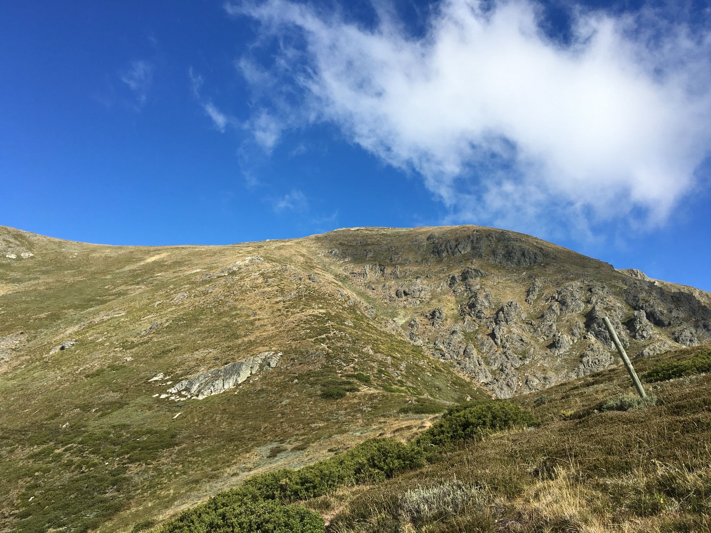
From the Mountain Creek picnic area the track heads west up the flank of the Bogong massif, climbing through tall alpine ash and then into a long, sustained ladder of stone-pitched steps and root-braided track through snow gum on the Staircase Spur. Bivouac Hut, roughly two-thirds of the way up at about 1,600 m, marks the point where the forest opens onto exposed snowgrass ridge. The final section crosses the treeless alpine plateau on marked route past the T-intersection with the Eskdale Spur to the summit cairn at 1,986 m, with unbroken 360-degree views over the Bogong High Plains, Mount Feathertop, Mount Hotham, the Nunniong plateau and — on the clearest days — Bass Strait to the south and the Snowy Mountains to the north-east.
The most efficient descent is to reverse the ascent. A longer alternative drops off the summit plateau on the Eskdale Spur and closes the loop back to Mountain Creek — around 21.5 km with a longer, gentler descent.
Why it is essential
Mount Bogong is Victoria’s highest point and the signature strenuous day of the state. The Staircase Spur combines one of the greatest base-to-summit reliefs on the Australian mainland with an exposed alpine summit, and it is the anchor summit day of any Bogong-based visit.
Equipment
- Sturdy boots with good grip
- Full weatherproof shell (jacket and overtrousers)
- Insulating warm layer plus a spare
- Hat and gloves outside midsummer
- Water: 3 litres per person; the spur is dry above the lower creek crossings
- Food for a long day
- Sun protection — extreme UV on the alpine plateau
- Trekking poles useful for the sustained climb and descent
- Map and compass or GPS; the plateau is easy to misread in cloud
- PLB or satellite messenger recommended — no phone reception
Hazards and notes
Weather is the primary hazard. Cloud and rapid weather change on the alpine plateau, high wind, whiteout, and lightning strike on the exposed summit are all documented incident causes. Turn back at Bivouac Hut if conditions are deteriorating. The descent is where injuries most commonly occur — steep, sustained and hard on the knees. Snow can persist on the plateau into November and can return from April. Snakes are possible below the treeline in warmer months. Dogs are not permitted in Alpine National Park.
GPX / route file
| Source | URL | Format | Licence / terms | Reuse |
|---|---|---|---|---|
| Parks Victoria — Staircase Spur page | parks.vic.gov.au | Web description | Copyright Parks Victoria | Reference only |
| OpenStreetMap — Staircase Spur / summit | osm.org | OSM way data | ODbL | Reusable with attribution |
| Australian Alps Walking Track — route relation | waymarkedtrails.org | OSM route | ODbL | Reusable with attribution |
Sources
- Parks Victoria — Mount Bogong via the Staircase Spur
- Wikipedia — Mount Bogong (summit elevation cross-reference)
- Jaithmathang — Bogong Moth cultural page
2. Mount Feathertop via the Razorback
Snapshot
Itinerary
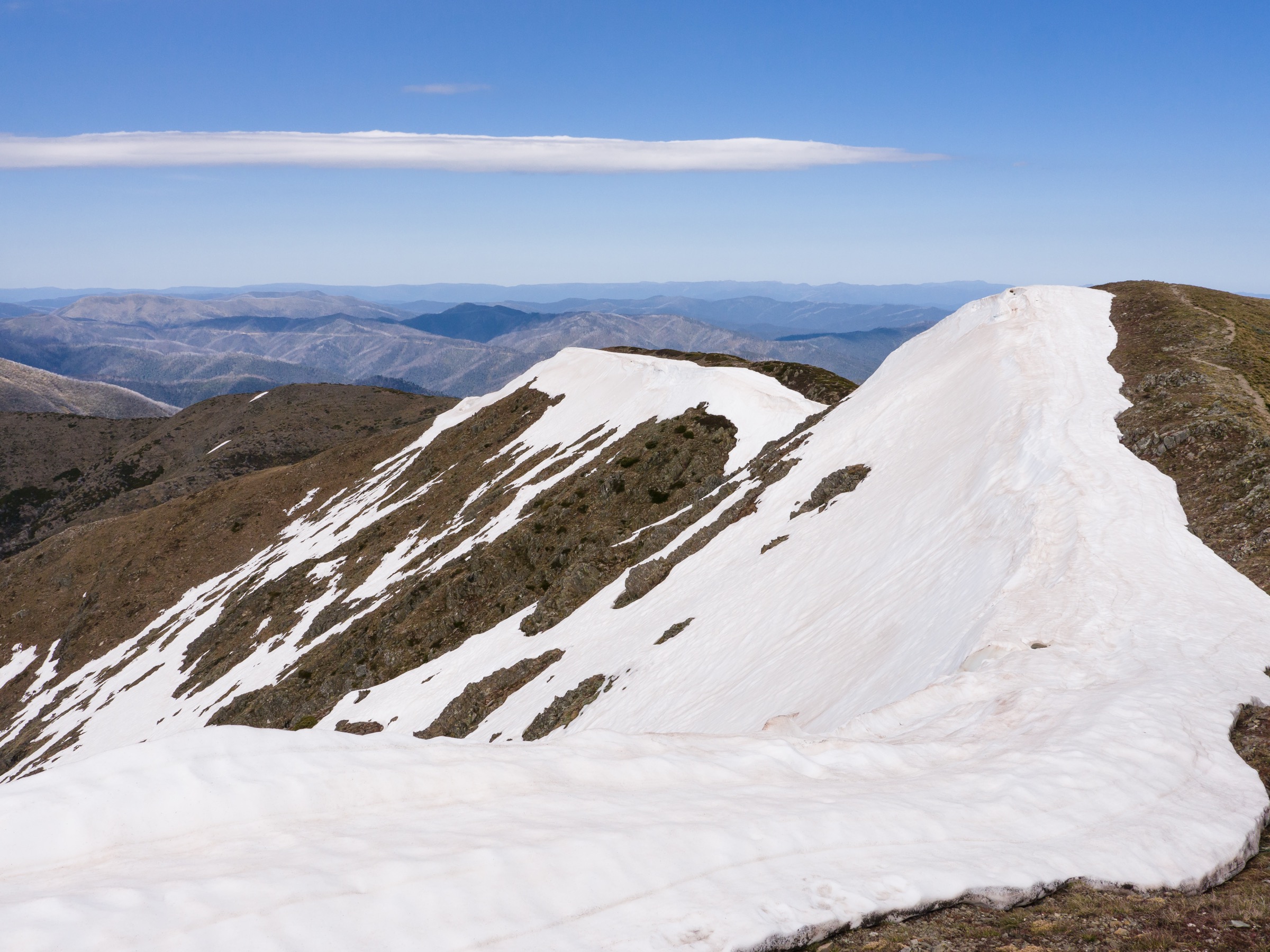
From Diamantina Hut on the Great Alpine Road the track drops immediately off the Hotham massif onto the narrow crest of the Razorback. The route then undulates north-west across a series of subalpine humps — Big Dipper, Twin Knobs, and the Cross Cut — along a ridge where the ground falls away steeply on both sides into the Bungalow Spur and the Diamantina headwaters. From the Cross Cut a short steep pinch climbs onto Feathertop’s cornice-topped summit at 1,922 m, with views back along the ridge to Hotham, across to Mount Loch and Mount Bogong, and — most famously — down the sharp west face into the Ovens valley.
Return by the same route. The turn-around point for weaker weather days is either at the Cross Cut junction or on the pinch itself, both of which can be reached and reversed inside the day.
Why it is essential
The Razorback is widely regarded as the most iconic ridgewalk in Victoria and one of the sharpest alpine profiles on the Australian mainland. It gives an uninterrupted alpine outlook the entire length with a genuine summit at the end.
Equipment
- Sturdy boots
- Full weatherproof shell and warm layers
- Hat and gloves outside midsummer
- Water: 2–3 litres per person; no reliable water on the ridge
- Sun protection — extreme UV on the exposed ridge
- Trekking poles useful for the undulations
- PLB or satellite messenger recommended — no phone reception on the ridge
- Microspikes may be useful in early or late season if hard snow lingers on the summit pinch
Hazards and notes
The ridge has no shelter and no water. Cloud and rapid weather change reduce visibility on the crest; whiteout is a real risk. Cornices and unstable snow persist into late spring on the summit pinch. Lightning strike is a recognised hazard in summer thunderstorm cells. The steep summit pinch is where injuries most often occur on descent. Dogs are not permitted in Alpine National Park.
GPX / route file
| Source | URL | Format | Licence / terms | Reuse |
|---|---|---|---|---|
| Parks Victoria — The Razorback Walk | parks.vic.gov.au | Web description | Copyright Parks Victoria | Reference only |
| OpenStreetMap — Razorback / Feathertop | osm.org | OSM way data | ODbL | Reusable with attribution |
Sources
- Parks Victoria — The Razorback Walk
- Wikipedia — Mount Feathertop
3. The Horn (Mount Buffalo)
Snapshot
Itinerary
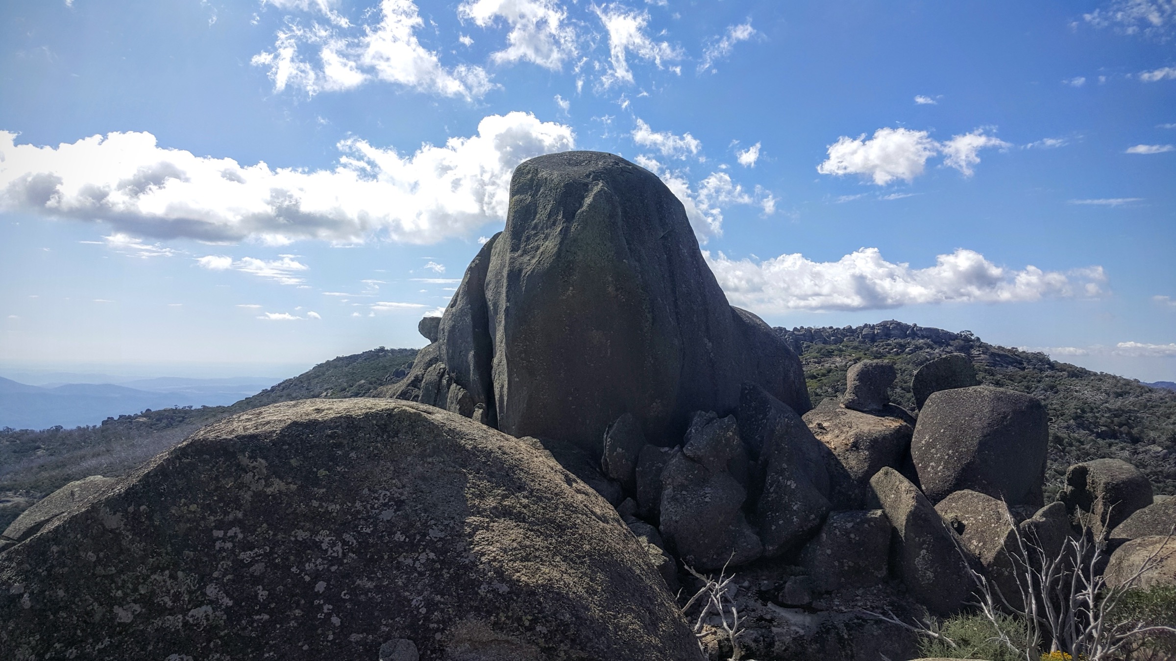
From the small car park at the end of Horn Road a graded track climbs west through wind-shaped snow gums onto the granite summit dome. Interpretive signage covers the plateau’s Devonian granite geology, its exfoliation domes and its role as the highest point of Mount Buffalo. A stone shelter stands on the summit block itself, giving unobstructed 360-degree views over the Buckland Valley, the Buffalo plateau below, and the full sweep of the Victorian Alps to the east.
Why it is essential
The Horn is the highest point of Mount Buffalo and the most efficient way to sample the plateau’s granite-tor landscape and alpine outlook. It is the anchor short walk of any Mount Buffalo visit and gives a summit-style vantage in under an hour on the ground.
Equipment
- Standard hiking shoes or boots
- Weatherproof shell
- Warm layer
- Water: 1 litre per person
- Sun protection — extreme UV at plateau elevation
Hazards and notes
Cliff edges at the summit shelter — supervise children. Horn Road closes from the Thursday after the King’s Birthday long weekend until 15 September for snow season and is not accessible by private vehicle in winter. Lightning strike on the exposed summit is a documented summer thunderstorm hazard. Weather can shift very quickly at plateau elevation. Dogs are not permitted in Mount Buffalo National Park.
GPX / route file
| Source | URL | Format | Licence / terms | Reuse |
|---|---|---|---|---|
| Parks Victoria — The Horn Walk | parks.vic.gov.au | Web description | Copyright Parks Victoria | Reference only |
| OpenStreetMap — The Horn | osm.org | OSM way data | ODbL | Reusable with attribution |
Sources
- Parks Victoria — The Horn Walk
- Parks Victoria — Mount Buffalo National Park
4. Wallace–Cope Heritage Trail (Bogong High Plains)
Snapshot
Itinerary
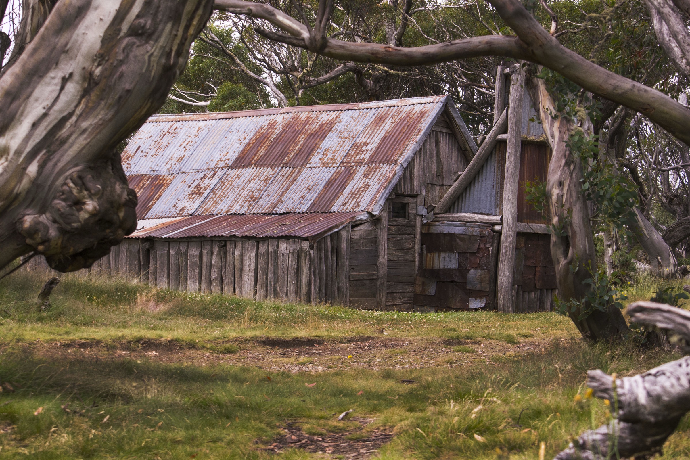
From the Wallaces Hut car park on the Bogong High Plains Road the track drops on gravel and boardwalk to Wallaces Hut — the oldest surviving hut in the Victorian Alps, built by the Wallace brothers in 1889 as a mountain-cattlemen summer shelter. The circuit continues east across snowgrass plain and a low ridge of open snow gum to Cope Hut, built by the Ski Club of Victoria in 1929 as a ski-touring shelter and now managed as a Parks Victoria historic building. The return line loops north back to the car park along the aqueduct and pipeline service track, with views across the High Plains to Mount Cope and Mount Jim.
Why it is essential
The Wallace–Cope circuit is the most accessible day-walk on the Bogong High Plains and the clearest single walk through the mountain-cattlemen and ski-club hut heritage that defines the Victorian Alps culturally. It gives a full sample of the High Plains landscape — snowgrass, snow gum and open plateau — in a half day.
Equipment
- Hiking shoes or boots
- Weatherproof shell and warm layer
- Hat and gloves outside midsummer
- Water: 1.5–2 litres per person
- Sun protection — extreme UV on the plateau
- Trekking poles useful on the pipeline track
- Map or GPS — the plateau is easy to misread in cloud
Hazards and notes
The plateau has no shelter between huts in bad weather; whiteout is a real risk when cloud is on the ground. Cornice and snowdrift persist into late spring in a normal winter. Snakes are possible in warmer months. The wheelchair-accessible spur to Wallaces Hut is 700 m one-way on gravel and boardwalk from the car park. Dogs are not permitted in Alpine National Park.
GPX / route file
| Source | URL | Format | Licence / terms | Reuse |
|---|---|---|---|---|
| Parks Victoria — Wallace Hut page | parks.vic.gov.au | Web description | Copyright Parks Victoria | Reference only |
| Parks Victoria — Alpine NP visitor guide | parks.vic.gov.au | PDF map | Copyright Parks Victoria | Reference only |
| OpenStreetMap — Wallace / Cope circuit | osm.org | OSM way data | ODbL | Reusable with attribution |
Sources
- Parks Victoria — Wallace Hut page
- Parks Victoria — Alpine National Park visitor guide
- Australian Alps National Parks — huts programme
5. Chalwell Galleries and Monolith circuit (Mount Buffalo)
Snapshot
Itinerary
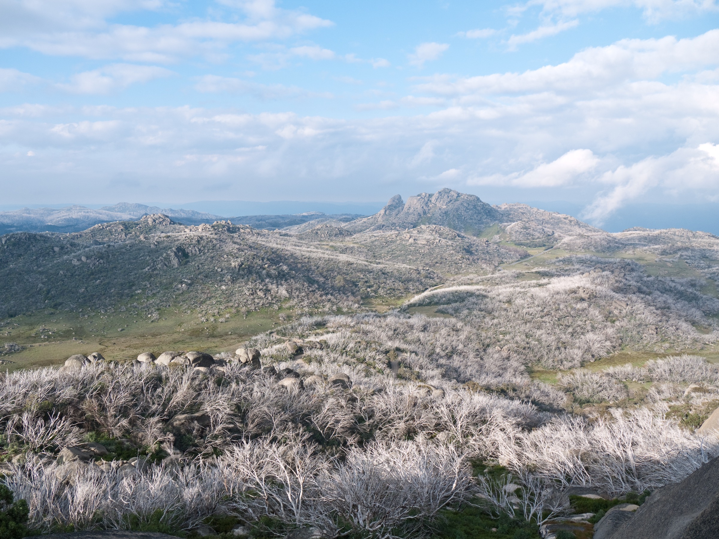
From the Chalwell Galleries car park the track descends into a series of narrow granite corridors and boulder passages formed where blocks have slid off the plateau’s exfoliation domes. The track squeezes through the “Galleries” themselves — several tight rock passages where large packs must be removed — before climbing back onto the plateau. A short extension climbs to The Monolith, a large granite tor rising above the plateau surface with 360-degree views over the Buffalo plateau, The Horn, the Buckland Valley and the Alpine National Park across the valley to the south-east. The return line drops back through open snow gum and follows the Lakeside track around the northern shore of Lake Catani back to the trailhead.
Why it is essential
The Chalwell Galleries and Monolith circuit is the clearest single walk through Mount Buffalo’s granite-tor geology. It combines the plateau’s characteristic exfoliation-block passages with a summit-style vantage from the Monolith and Lake Catani forest, and it is walkable in shoulder-season conditions when The Horn is closed by snow.
Equipment
- Sturdy hiking shoes or boots
- Weatherproof shell
- Warm layer
- Water: 1.5–2 litres per person
- Sun protection
- Small pack — some Galleries passages require removing a large pack
- Headtorch useful for shaded rock passages
Hazards and notes
Narrow rock passages in the Galleries are unsuitable for those uncomfortable with heights or confined spaces. Granite is slippery when wet. Lake Catani Road closes from the Thursday after the King’s Birthday long weekend until 15 September. Weather can shift quickly at plateau elevation and lightning strike is a documented summer hazard. Dogs are not permitted in Mount Buffalo National Park.
GPX / route file
| Source | URL | Format | Licence / terms | Reuse |
|---|---|---|---|---|
| Parks Victoria — Chalwell Galleries Walk | parks.vic.gov.au | Web description | Copyright Parks Victoria | Reference only |
| Parks Victoria — Mount Buffalo National Park | parks.vic.gov.au | Web description and map | Copyright Parks Victoria | Reference only |
| OpenStreetMap — Chalwell / Monolith / Lake Catani | osm.org | OSM way data | ODbL | Reusable with attribution |
Sources
- Parks Victoria — Chalwell Galleries Walk
- Parks Victoria — Mount Buffalo National Park
Region-level sources
| Source | Type | Notes |
|---|---|---|
| Parks Victoria — Alpine National Park | Official park authority | Primary source for Bogong, Feathertop, Bogong High Plains walks |
| Parks Victoria — Mount Buffalo National Park | Official park authority | Primary source for The Horn and Chalwell Galleries |
| Parks Victoria — Alpine NP visitor guide (PDF) | Official park map | Consolidated walk map and closures |
| Taungurung Land and Waters Council — taungurung.com.au | Registered Aboriginal Party | Cultural attribution for Taungurung country |
| Dhudhuroa Waywurru Nations — external references | Registered Aboriginal Party | Cultural attribution for Dhudhuroa and Waywurru country |
| Jaithmathang — jaithmathang.com.au | Registered Aboriginal Party | Cultural attribution and Bogong Moth cultural page |
| OpenStreetMap — openstreetmap.org | Community map | Track geometry cross-checking |
| Bureau of Meteorology — bom.gov.au | Federal weather bureau | Frontal timing, snow and lightning risk |
Further reading
Nearby Great Dividing Range guides on Storm
- ACT, Namadgi and the Brindabella Ranges
- Atherton Tablelands / Cairns Highlands
- Barrington Tops
- Blue Mountains
-
Storm — Australia | Central Victorian Highlands: Essential Day-Hikes
- Storm — Australia | Dandenong Ranges and Yarra Ranges: Essential Day-Hikes
- Storm — Australia | Snowy Mountains and Kosciuszko: Essential Day-Hikes
Missing data / follow-up work
- Parks Victoria’s Staircase Spur page currently prints Mount Bogong’s height as 1,926 m; this appears to be a transposition of the widely accepted 1,986 m and should be verified against Geoscience Australia AHD survey data.
- Parks Victoria does not publish an official distance for The Razorback Walk; the 22 km figure comes from bushwalking directory sources and should be treated as an approximation.
- The Chalwell Galleries + Monolith combined distance (~6–7 km) is a compilation from Parks Victoria’s individual walk pages and Bushwalking Victoria track notes; no single published loop distance was found.
- Parks Victoria does not publish official GPX downloads for any of the five walks; OpenStreetMap and the Australian Alps Walking Track OSM route relation are the most reliable geometry sources.
- Cultural attribution for Warkwoolowler and the Waywurru / Dhudhuroa spellings varies between community and academic sources; verify with the relevant Registered Aboriginal Parties where accuracy matters.
- Falls Creek shuttle and Mount Hotham resort transport arrangements change season to season; verify at the operator’s website before travel.