Regional overview
Bariloche and Nahuel Huapi form the classic Argentine Lake District walking hub: glacial lakes, coihue forest, granite spires, high refugios, volcanic summits, public bus access and a long Club Andino / national-park trail culture. The compact west side of Bariloche gives short viewpoints on Circuito Chico, while the Cerro Catedral, López and Colonia Suiza sectors provide strenuous day hikes to alpine lakes and huts.
The hiking character is more alpine than the lake-shore scenery first suggests. Refugio Frey, Refugio López and Laguna Negra involve long ascents, rocky upper sections, rapid weather changes and mandatory trekking registration where required by Parque Nacional Nahuel Huapi. Snow and ice can remain well beyond winter; Bariloche Trekking and park pages repeatedly flag crampon/ice-axe conditions outside the summer window.
The practical main season for high routes is December-April. Short viewpoints such as Cerro Campanario and Cerro Llao Llao are more flexible, though rain, mud, wind and forest closures still matter.
Selection rationale
The selection balances three mountain-refugio objectives with two famous Circuito Chico viewpoints: Refugio Frey for the Catedral granite amphitheatre, Cerro López for the classic high lake panorama, Laguna Negra / Refugio Italia for the Colonia Suiza valley, Cerro Llao Llao for the forested municipal-park hill, and Cerro Campanario for the most iconic short viewpoint over the lake district.
Summary table
| # | Hike | Country | Route type | Distance | Gain | Max elevation | Difficulty |
|---|---|---|---|---|---|---|---|
| 1 | Refugio Frey from Villa Catedral | Argentina | Out-and-back | 18.0 km official return estimate; 19.6 km AllTrails | 700 m official one-way gain; 838 m AllTrails return | 1,700 m at Refugio Frey / Laguna Toncek | Hard |
| 2 | Cerro López / Refugio López and Pico Turista | Argentina | Out-and-back | 11.7 km AllTrails; Bariloche Trekking lists 5.8 km one way to Pico Turista | 1,260–1,270 m | Approx. 2,075 m at Pico Turista; exact max unresolved | Hard |
| 3 | Refugio Italia / Laguna Negra from Colonia Suiza | Argentina | Out-and-back | 22.0 km official return estimate; 20.6 km AllTrails | 800 m official one-way gain; 906 m AllTrails return | Approx. 1,650 m at Laguna Negra / Refugio Italia | Hard |
| 4 | Cerro Llao Llao and Villa Tacul viewpoint | Argentina | Out-and-back / loop variants | 5.6 km Cerro Llao Llao AllTrails; longer 8–17 km park loops possible | 273 m | Moderate | |
| 5 | Cerro Campanario from Circuito Chico | Argentina | Out-and-back | 2.0 km return on Bariloche Trekking; 2.25 km AllTrails | 214–240 m | 1,050 m summit/viewpoint | Easy-moderate |
1. Refugio Frey from Villa Catedral
Snapshot
Itinerary
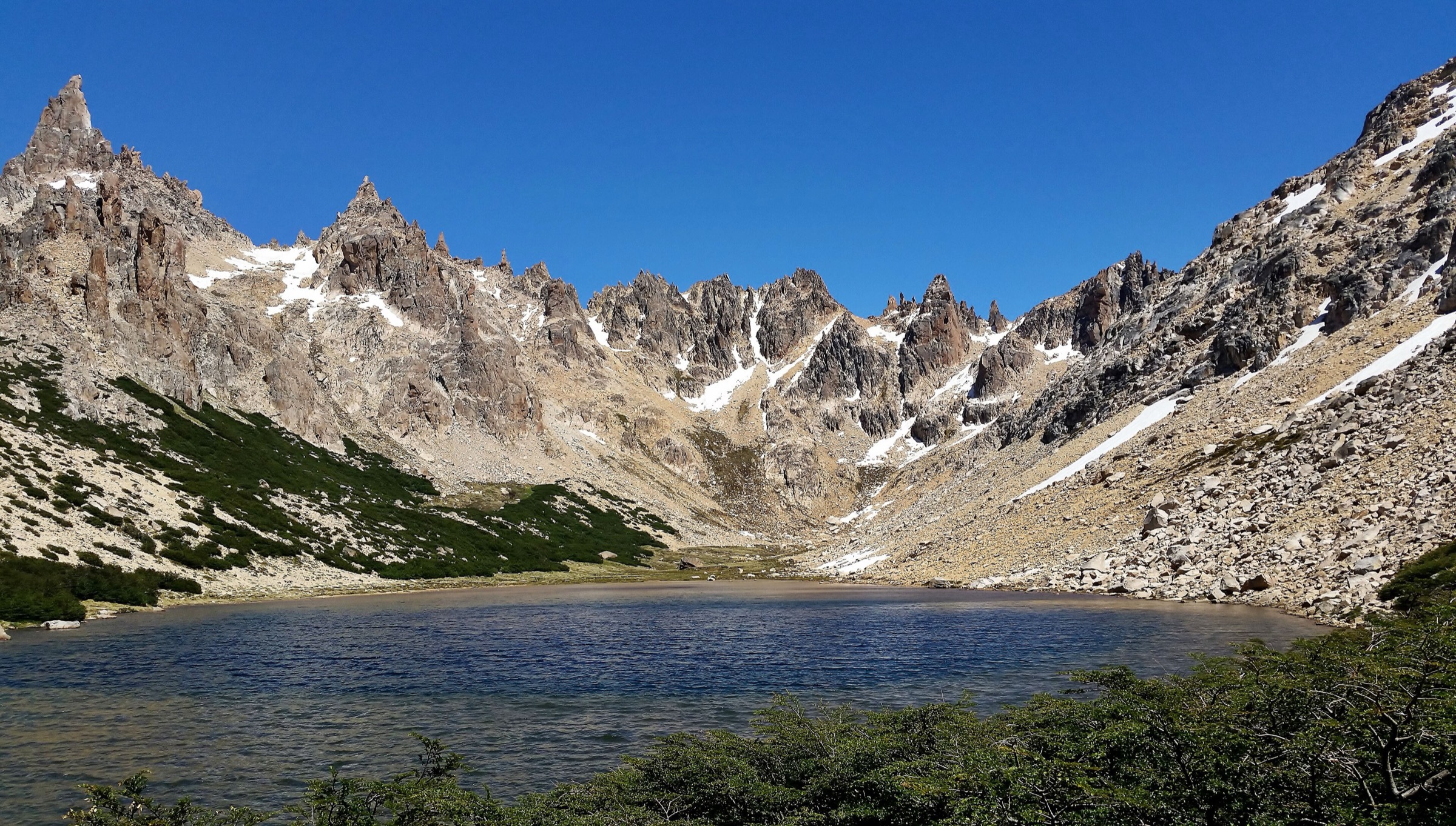
From the Cerro Catedral base, the route crosses the ski-area base and follows the signed Frey trail through forest and open slopes. Bariloche Trekking describes the route joining the Lago Gutiérrez variant near Arroyo Van Titter, passing Refugio Piedritas and climbing the steeper final section to Refugio Emilio Frey beside Laguna Toncek. The return follows the same route unless deliberately exiting by the Villa Los Coihues variant.
Why it is essential
Refugio Frey is Bariloche’s classic mountain day hike: a dramatic granite amphitheatre, alpine lake, historic hut and accessible public-transport trailhead in one route.
Equipment
- Mountain hiking footwear
- Rain/wind shell
- Warm layers
- Sun protection
- Food, water
- Headtorch
- Offline map/GPS
- Trekking poles
- Snow/ice equipment may be required outside normal summer conditions
Hazards and notes
- The national park requires trekking registration for this route
- The upper trail has rocks, exposed sun, sudden storms and possible snow
- Overnight stays or camping at Frey require confirmed reservation
- The day-hike version should not assume hut availability beyond emergency advice and paid services
GPX / KML links
| Source | URL | Format / access | Reuse status |
|---|---|---|---|
| Parque Nacional Nahuel Huapi: Refugio Frey desde Villa Catedral | nahuelhuapi.gov.ar | Official page with GPX/KML/GEOJSON links | Official route-file terms not stated; reuse terms unresolved |
| Bariloche Trekking: Base Cerro Catedral - Refugio Emilio Frey | barilochetrekking.com | Source page with downloadable track | Site terms not fully assessed; reuse unresolved |
| AllTrails: Refugio Frey via Villa Cerro Catedral | alltrails.com | Source map / downloadable route via AllTrails account | AllTrails terms apply; source-map reference only |
External links
- Parque Nacional Nahuel Huapi — Refugio Frey desde Villa Catedral
- Bariloche Trekking — Base Cerro Catedral - Refugio Emilio Frey
- AllTrails — Refugio Frey
2. Cerro López / Refugio López and Pico Turista
Snapshot
Itinerary
The route starts beside Arroyo López on Circuito Chico and climbs steeply through forest, roots and eroded ground toward Roca Negra and Refugio López. From the refugio, fit parties continue toward La Hoya and Pico Turista for the broader view over Nahuel Huapi, Tronador, the López massif and the lake arms.
Why it is essential
Cerro López is the classic high viewpoint above Circuito Chico. It gives a major elevation gain, a mountain hut, and one of the finest lake-and-Tronador panoramas reachable as a day hike from Bariloche.
Equipment
- Mountain boots or shoes
- Trekking poles
- Rain/wind shell
- Warm layers
- Sun protection
- Food, water
- Headtorch
- Navigation
- Extra footwear or expect wet feet if Arroyo López is high near the refugio
Hazards and notes
- Bariloche Trekking warns that from July to December ice axe and crampons may be needed, only with good mountain knowledge
- Erosion, roots, loose stones, stream crossings, snow and poor visibility are major hazards
- Avoid expert-only ridge variants such as the Bahía López-Palotinos route unless specifically qualified
GPX / KML links
| Source | URL | Format / access | Reuse status |
|---|---|---|---|
| Bariloche Trekking: Arroyo López - Refugio López | barilochetrekking.com | Source page with downloadable track | Site terms not fully assessed; reuse unresolved |
| Parque Nacional Nahuel Huapi: Cerro López | nahuelhuapi.gov.ar | Official route context linking Bariloche Trekking | No file found directly on park page; official context only |
| AllTrails: Mount López | alltrails.com | Source map / downloadable route via AllTrails account | AllTrails terms apply; source-map reference only |
External links
- Parque Nacional Nahuel Huapi — Cerro López
- Bariloche Trekking — Arroyo López - Refugio López
- AllTrails — Mount López
3. Refugio Italia / Laguna Negra from Colonia Suiza
Snapshot
Itinerary
The official route follows a vehicle track and trail beside Arroyo Goye through forest and valley terrain. After about three hours it crosses the Navidad and Goye streams, then steepens into the zigzag “caracoles” that climb to Refugio Italia beside Laguna Negra. A short additional viewpoint from the lake margin is possible but adds exposure and time.
Why it is essential
Laguna Negra is the great Colonia Suiza hut hike and a core part of Bariloche’s refugio culture. It complements Frey and López with a quieter forested valley, waterfall/stream terrain and a dark alpine lake basin.
Equipment
- Mountain hiking footwear
- Rain/wind shell
- Warm layers
- Sun protection
- 2 litres or more of water or treatment
- Food
- Headtorch
- Offline map/GPS
- Poles
Hazards and notes
- The national park page says trekking registration is mandatory
- Prohibits fire/pernocte along the route outside authorised/reserved refuge or camping arrangements
- Temporary closures occur when water, snow, mud or safety conditions are poor
- This is a very long return day, so many walkers treat it as an overnight
GPX / KML links
| Source | URL | Format / access | Reuse status |
|---|---|---|---|
| Parque Nacional Nahuel Huapi: Arroyo Goye - Refugio Italia | nahuelhuapi.gov.ar | Official page with GPX/KML/GEOJSON links | Official route-file terms not stated; reuse terms unresolved |
| AllTrails: Sendero Refugio Italia - Laguna Negra | alltrails.com | Source map / downloadable route via AllTrails account | AllTrails terms apply; source-map reference only |
| Refugio Laguna Negra official site | refugiolagunanegra.com | Hut/access context | No route-file licence assessed; hut reservation/status context |
External links
- Parque Nacional Nahuel Huapi — Arroyo Goye - Refugio Italia
- AllTrails — Sendero Refugio Italia - Laguna Negra
- Refugio Laguna Negra
4. Cerro Llao Llao and Villa Tacul viewpoint
Snapshot
Itinerary
The basic hike climbs through the mixed forest of Parque Municipal Llao Llao to the Cerro Llao Llao viewpoint. The municipal park also lists connected trails to Arrayanes, Brazo Tristeza, Puente Romano, Lago Escondido and Bahía de los Troncos, allowing a longer Circuito Chico forest-and-beach loop for walkers with more time.
Why it is essential
Cerro Llao Llao is the essential low-elevation forest viewpoint in Bariloche: accessible, scenic and deeply representative of the Nahuel Huapi lake-and-forest edge.
Equipment
- Walking shoes or light hiking shoes
- Rain layer
- Water, snacks
- Sun protection
- Offline map if combining multiple park trails
Hazards and notes
- The municipal park asks visitors to stay on trails, carry out waste, avoid fire/camping, enter without pets and not cycle on walking trails
- Wet roots and mud are common after rain
GPX / KML links
| Source | URL | Format / access | Reuse status |
|---|---|---|---|
| AllTrails: Cerro Llao Llao via Villa Tacul Trail | alltrails.com | Source map / downloadable route via AllTrails account | AllTrails terms apply; source-map reference only |
| Municipalidad de Bariloche: Parque Municipal Llao Llao | bariloche.gov.ar | Official municipal park source | No route file found in this pass; official context only |
External links
5. Cerro Campanario from Circuito Chico
Snapshot
Itinerary
The footpath starts beside the Cerro Campanario chairlift base and climbs a short, steep forested track to the summit viewpoint. The summit has a developed lookout and services, with sweeping views over Nahuel Huapi, Moreno, El Trébol, Llao Llao, Victoria Island, Cerro López, Cerro Catedral and the surrounding lake arms.
Why it is essential
Campanario is Bariloche’s most famous quick viewpoint. It is not a wilderness hike, but it is the clearest single visual summary of the Argentine Lake District.
Equipment
- Walking shoes with grip
- Water
- Sun/rain protection
- Warm layer for the exposed viewpoint
- Trekking poles help on the steep descent
Hazards and notes
- The path is short but steep and irregular
- Wet mud, roots, crowding and chairlift/tourist traffic are the main issues
- Bariloche Trekking states that this trail does not require national-park trekking registration
GPX / KML links
| Source | URL | Format / access | Reuse status |
|---|---|---|---|
| Bariloche Trekking: Cerro Campanario | barilochetrekking.com | Source page with downloadable track | Site terms not fully assessed; reuse unresolved |
| AllTrails: Campanario Hill | alltrails.com | Source map / downloadable route via AllTrails account | AllTrails terms apply; source-map reference only |
External links
Missing data and follow-up
- Specific licence-compatible cover and per-hike Commons images need verification before publication; only Commons category/search links are available in this pass.
- Official Parque Nacional Nahuel Huapi GPX/KML/GEOJSON reuse terms are not stated and need confirmation.
- Bariloche Trekking and AllTrails track-file reuse terms are not assessed.
- Current Bariloche bus line numbers and schedules for each trailhead need a date-specific check.
- Trekking registration requirements and any seasonal closures on Frey, López and Laguna Negra should be confirmed close to travel.
External links
| Source | URL |
|---|---|
| Parque Nacional Nahuel Huapi — Refugio Frey desde Villa Catedral | nahuelhuapi.gov.ar |
| Parque Nacional Nahuel Huapi — Cerro López | nahuelhuapi.gov.ar |
| Parque Nacional Nahuel Huapi — Arroyo Goye - Refugio Italia | nahuelhuapi.gov.ar |
| Bariloche Trekking — Base Cerro Catedral - Refugio Emilio Frey | barilochetrekking.com |
| Bariloche Trekking — Arroyo López - Refugio López | barilochetrekking.com |
| Bariloche Trekking — Sendero Cerro Campanario | barilochetrekking.com |
| Municipalidad de Bariloche — Parque Municipal Llao Llao | bariloche.gov.ar |
| Refugio Laguna Negra | refugiolagunanegra.com |
| AllTrails — Refugio Frey via Villa Cerro Catedral | alltrails.com |
| AllTrails — Mount López | alltrails.com |
| AllTrails — Sendero Refugio Italia - Laguna Negra | alltrails.com |
| AllTrails — Cerro Llao Llao via Villa Tacul | alltrails.com |
| AllTrails — Cerro Campanario | alltrails.com |