Regional overview
Parque Nacional Tierra del Fuego protects the south-western corner of Argentina’s Isla Grande de Tierra del Fuego, where subantarctic forest, peat bog, low mountains, lakes, rivers and Beagle Channel coastline meet at the end of National Route 3. Compared with the higher Ushuaia backcountry, the park’s walking character is more managed and varied: coastal traverses, lake-border paths, short boardwalk-style trails and one strenuous mountain summit route.
The main public-use zones are Ensenada Zaratiegui, Lago Roca / Acigami, Alakush visitor centre, Lapataia Bay, Rio Pipo and the route corridor between them. Most official trails are short to moderate, but the combination of Senda Costera, Hito XXIV, Pampa Alta and Cerro Guanaco allows a full range from easy interpretive walking to steep alpine terrain.
The main trail season for the longer routes is November-April. Some short trails are open year-round, but winter brings short daylight, sub-zero temperatures, snow, ice and reduced services. Dogs, fires, off-trail travel and disturbance of wildlife are controlled by park rules. Park entry, shuttle timing and any registration requirement should be checked before arrival.
Selection rationale
The selection covers the five essential walking experiences in the park: the coastal traverse on Senda Costera, the summit panorama of Cerro Guanaco, the lake-and-border walk to Hito XXIV, the forest viewpoint traverse of Pampa Alta, and a linked Lapataia Bay short-trail circuit combining the park’s main lowland interpretive paths. Laguna del Caminante is omitted here because it is already included in the Ushuaia / Martial Mountains article and its access points lie outside the park jurisdiction.
Summary table
| # | Hike | Country | Route type | Distance | Gain | Max elevation | Difficulty |
|---|---|---|---|---|---|---|---|
| 1 | Senda Costera | Argentina | Point-to-point / coastal traverse | 8.0 km | 70 m | Low | Moderate |
| 2 | Cerro Guanaco from Lago Roca / Acigami | Argentina | Out-and-back | 12.0 km official return; AllTrails 13.7 km | 900 m official; AllTrails 1,043 m | Approx. 970-1,100 m depending source | Hard |
| 3 | Hito XXIV | Argentina | Out-and-back | 7.0 km official return; FDM lists 8 km | 10 m official | Low | Moderate |
| 4 | Pampa Alta | Argentina | Point-to-point / traverse | 4.7 km | 252 m | Moderate | |
| 5 | Lapataia Bay short-trail circuit | Argentina | Linked short trails / loop variants | Approx. 5.0-6.0 km depending connectors | Approx. 60 m total across official component trails | Low | Easy |
1. Senda Costera
Snapshot
Itinerary
Senda Costera starts at Ensenada Zaratiegui and follows the Beagle Channel coastline through forest, small beaches, coastal viewpoints and low undulating ground. The route finishes near the Route 3 / Lago Roca access junction close to the Alakush visitor centre. Argentina National Parks lists the trail at 8 km, 4 hours and 70 m total elevation gain.
The route is mostly coastal-marine in character, with views toward islands, forested shorelines and the channel. Because it is point-to-point, walkers should plan transport or combine it with other park routes and road walking only where safe and permitted.
Why it is essential
Senda Costera is the park’s defining coastal hike and the best way to experience its rare combination of subantarctic forest and sea. It is also the essential moderate route for visitors who want a substantial walk without the steepness of Cerro Guanaco.
Equipment
Standard hiking equipment: hiking shoes or boots, waterproof/windproof shell, warm layer, water, food, sun protection and offline map/GPS. Trekking poles are optional but useful on muddy sections.
Hazards and notes
The trail is exposed to wind, rain, wet roots, muddy ground and slippery coastal sections. It is officially enabled between November and April for visitors with minimum physical training and prior information. Do not leave the trail or approach sensitive shoreline areas outside permitted access.
GPX / KML links
| Source | URL | Format / access | Reuse status |
|---|---|---|---|
| Argentina National Parks: Senderos del Parque Nacional Tierra del Fuego | argentina.gob.ar | Official route page | Route-file terms not stated; official stats/context only; no GPX found |
| Gaia GPS: Senda Costera nearby trail source | gaiagps.com | GPX/KML-capable route database | Gaia terms apply; search/source-map reference; direct route not retrieved in this pass |
| OpenStreetMap search: Senda Costera Tierra del Fuego | openstreetmap.org | Map geometry cross-check | OSM data is ODbL; geometry cross-check target only |
External links
- Argentina National Parks — Senderos del Parque Nacional Tierra del Fuego
- Ushuaia tourism — Trekking en el Parque
- Fin del Mundo tourism — trail listings
2. Cerro Guanaco from Lago Roca / Acigami
Snapshot
Itinerary
The route begins at the Lago Roca / Acigami parking area and initially follows the Hito XXIV trail for almost 900 m. At the signed fork, the Cerro Guanaco route climbs through forest, peatland and higher alpine terrain. The ascent is steep and sustained, eventually reaching the summit/viewpoint above the national park.
Argentina National Parks lists the trail as 6 km one way, 900 m total gain, high difficulty and 4 hours to the summit, with a maximum entry time of 12:30. AllTrails records the full out-and-back as 13.7 km with about 1,043 m of gain and a 6.5-7 hour estimate. The route is suitable only for walkers with mountain fitness, proper footwear and current weather information.
Why it is essential
Cerro Guanaco is the park’s essential mountain hike. It gives the strongest high viewpoint over Lago Roca / Acigami, Lapataia, the Beagle Channel, peatlands, forests and the Fuegian cordillera from inside the national park.
Equipment
Mountain hiking equipment: sturdy boots, trekking poles, waterproof/windproof shell, warm layers, gloves and hat, water, food, sun protection, headtorch, offline map/GPS and navigation backup.
Hazards and notes
The route is steep, exposed and weather-sensitive. Mud, snow, ice, wind and poor visibility can make the upper route unsafe. Registration/permission is required according to AllTrails access notes and APN lists a last-entry time. Start early and confirm opening status at the park before committing.
GPX / KML links
| Source | URL | Format / access | Reuse status |
|---|---|---|---|
| AllTrails: Cerro Guanaco Summit Trail | alltrails.com | Source map / downloadable route via AllTrails account | AllTrails terms apply; direct GPX not retrieved; source-map reference only |
| Argentina National Parks: Senderos del Parque Nacional Tierra del Fuego | argentina.gob.ar | Official route page | Route-file terms not stated; official stats/context only |
| OpenStreetMap search: Cerro Guanaco Tierra del Fuego | openstreetmap.org | Map geometry cross-check | OSM data is ODbL; geometry cross-check target only |
External links
- Argentina National Parks — Senderos del Parque Nacional Tierra del Fuego
- AllTrails — Cerro Guanaco Summit Trail
- Ushuaia tourism — Trekking en el Parque
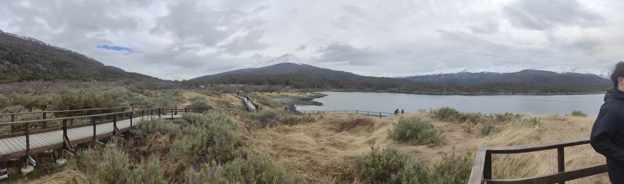
3. Hito XXIV
Snapshot
Itinerary
The route begins at the Lago Roca / Acigami parking area and shares its first section with the Cerro Guanaco route. After the fork, it keeps left and follows the lakeshore toward the Hito XXIV marker on the Argentina-Chile border. The walk passes through lenga forest and lacustrine-coastal terrain with views across the lake and surrounding mountains.
Argentina National Parks gives 3.5 km one way, 3 hours return and 10 m total elevation gain. The Fin del Mundo tourism page lists 8 km return, which likely reflects a slightly longer practical walked route from the public access point. The route is well marked and much less strenuous than Cerro Guanaco, but it is still a real day walk in a remote park setting.
Why it is essential
Hito XXIV is the park’s classic lake-border walk. It combines forest, Lago Roca / Acigami, mountain views and the international boundary with Chile, giving a low-elevation contrast to Senda Costera and Cerro Guanaco.
Equipment
Standard hiking equipment: hiking shoes or boots, waterproof/windproof layer, warm layer, water, snacks, sun protection and offline map/GPS.
Hazards and notes
The route is open November-April and requires minimum fitness and prior information according to APN. Autumn/winter conditions involve short daylight, freezing temperatures, snow and ice. Do not continue beyond permitted border areas or enter Chile outside official procedures.
GPX / KML links
| Source | URL | Format / access | Reuse status |
|---|---|---|---|
| Argentina National Parks: Senderos del Parque Nacional Tierra del Fuego | argentina.gob.ar | Official route page | Route-file terms not stated; official stats/context only |
| Fin del Mundo tourism: Hito XXIV trail | fdm.tierradelfuego.org.ar | Official/provincial tourism route page with download buttons | Download terms not stated; source route candidate; verify file terms before reuse |
| Gaia GPS: Sendero Hito XXIV | gaiagps.com | GPX/KML-capable route page | Gaia/user terms apply; source route candidate; reuse unresolved |
| OpenStreetMap search: Hito XXIV Tierra del Fuego | openstreetmap.org | Map geometry cross-check | OSM data is ODbL; geometry cross-check target only |
External links
- Argentina National Parks — Senderos del Parque Nacional Tierra del Fuego
- Fin del Mundo tourism — Hito XXIV trail
- Gaia GPS — Sendero Hito XXIV
4. Pampa Alta
Snapshot
Itinerary
Pampa Alta connects the Ensenada side of the park with the Rio Pipo sector through forest and viewpoint terrain. Argentina National Parks lists 4.7 km, 2 hours and 252 m total elevation gain. The trail has signed access points at both heads and along Route 3, and includes interpretive signage about the forest, its functions, historical uses and impacts.
The reward is a view over the Beagle Channel, Rio Pipo valley and Cerro Guanaco area. It can be walked as a point-to-point route if transport is arranged, or as a longer out-and-back from one side.
Why it is essential
Pampa Alta is the park’s best short forest-and-viewpoint traverse. It gives more ascent and perspective than the lowland Lapataia trails without the major commitment of Cerro Guanaco.
Equipment
Standard hiking equipment: hiking shoes or boots, waterproof/windproof shell, warm layer, water, snacks, sun protection and offline map/GPS. Trekking poles are useful if the path is wet.
Hazards and notes
Mud, wet roots, rain and wind are common. The route is enabled November-April for visitors with minimum training and prior information. If walked point-to-point, transport logistics must be planned before starting.
GPX / KML links
| Source | URL | Format / access | Reuse status |
|---|---|---|---|
| Argentina National Parks: Senderos del Parque Nacional Tierra del Fuego | argentina.gob.ar | Official route page | Route-file terms not stated; official stats/context only; no GPX found |
| OpenStreetMap search: Pampa Alta Tierra del Fuego | openstreetmap.org | Map geometry cross-check | OSM data is ODbL; geometry cross-check target only |
External links
- Argentina National Parks — Senderos del Parque Nacional Tierra del Fuego
- Ushuaia tourism — Trekking en el Parque
5. Lapataia Bay short-trail circuit
Snapshot
Itinerary
This entry links the main official short walks around Lapataia Bay and the Route 3 end area into a single lowland day-hike circuit. The component trails include La Baliza (1.2 km, 30 min, 6 m gain), Mirador Lapataia (980 m, 30 min, 25 m gain), Paseo de la Isla (1.3 km, 30 min, 12 m gain), Senda del Turbal (1.35 km, 40 min, 12 m gain) and Castorera (200 m, 20 min, 5 m gain). Depending on parking, connectors and closures, the practical outing is about 5-6 km.
The walk moves between coastal forest, peatland, bay viewpoints, old beaver impact areas and the symbolic end of National Route 3. It is not a single named official loop, so the exact combination should be adapted to current signage and any repair closures.
Why it is essential
Lapataia Bay is the park’s essential lowland and interpretive walking area. Linking the short trails gives a fuller picture of the bay, peatlands, forest and human-access infrastructure than any single 20-30 minute path.
Equipment
Comfortable walking shoes or light hiking footwear, waterproof/windproof layer, warm layer, water, snacks and sun protection. A small map or offline map helps combine the short trails efficiently.
Hazards and notes
Boardwalks, wet roots, mud and wind can still be slippery. La Baliza marks the limit with the Strict Nature Reserve zone; do not continue into closed areas. Argentina National Parks notes repair/adjudication work affecting Laguna Negra boardwalk/trail sections, so Laguna Negra is not used as a core component until current condition is confirmed.
GPX / KML links
| Source | URL | Format / access | Reuse status |
|---|---|---|---|
| Argentina National Parks: Senderos del Parque Nacional Tierra del Fuego | argentina.gob.ar | Official component trail stats | Route-file terms not stated; official stats/context only; no GPX found |
| Outdooractive: Lapataia Bay viewpoint trail | outdooractive.com | Source map route | Outdooractive terms apply; source-map reference only |
| OpenStreetMap search: Bahia Lapataia trails | openstreetmap.org | Map geometry cross-check | OSM data is ODbL; geometry cross-check target only |
External links
- Argentina National Parks — Senderos del Parque Nacional Tierra del Fuego
- Outdooractive — Lapataia Bay viewpoint trail
External links
| Source | URL |
|---|---|
| Argentina National Parks — Senderos del Parque Nacional Tierra del Fuego | argentina.gob.ar |
| Ushuaia tourism — Trekking en el Parque | turismoushuaia.com |
| Fin del Mundo tourism — Hito XXIV | fdm.tierradelfuego.org.ar |
| Fin del Mundo tourism — trail listings | fdm.tierradelfuego.org.ar |
| AllTrails — Cerro Guanaco Summit Trail | alltrails.com |
| Gaia GPS — Sendero Hito XXIV | gaiagps.com |
| Outdooractive — Lapataia Bay viewpoint trail | outdooractive.com |