Regional overview
El Chaltén is the northern walking base of Parque Nacional Los Glaciares and the main day-hiking gateway to the Fitz Roy / Cerro Torre massif. The hiking character is unusually direct for Patagonia: marked trails leave from the edge of town and reach glacier lakes, moraine ridges, lenga forest, open steppe viewpoints and high panoramic slopes without requiring huts or technical equipment in normal summer conditions.
The dominant objectives are Mount Fitz Roy, Cerro Torre, the Adela range, Laguna de los Tres, Laguna Torre, Laguna Capri and the exposed viewpoint of Loma del Pliegue Tumbado. Distances are moderate to long, but weather is the controlling factor. Wind, rain, sleet, poor visibility, stream levels, wet boardwalks, snow on final slopes and sudden temperature changes can make even well-trodden routes serious.
Access is mostly from El Chaltén on foot. The El Pilar / Río Eléctrico variant requires a vehicle transfer north of town and a return walk to El Chaltén. The practical main season is October-November to April-May, with the most stable visitor infrastructure in summer. Paid national-park entry applies on official trail pages for several routes; current ticketing and closures should be checked before walking.
Selection rationale
The selection gives the compact El Chaltén massif its five most representative day walks: the Fitz Roy close-view objective at Laguna de los Tres, the Cerro Torre valley approach to Laguna Torre, the high all-massif panorama of Loma del Pliegue Tumbado, the shorter Fitz Roy lake-and-forest route to Laguna Capri, and Chorrillo del Salto as the essential low-commitment waterfall and forest walk. Longer crossings such as Paso del Viento are excluded because they are multi-day and more committing.
Summary table
| # | Hike | Country | Route type | Distance | Gain | Max elevation | Difficulty |
|---|---|---|---|---|---|---|---|
| 1 | Laguna de los Tres via El Pilar / Río Eléctrico | Argentina | Point-to-point | 21.7 km | 959 m | 1,178 m | Hard |
| 2 | Laguna Torre and Cerro Torre viewpoint | Argentina | Out-and-back | 18.0 km | 576 m | 672 m | Hard |
| 3 | Loma del Pliegue Tumbado | Argentina | Out-and-back | 19.3 km | 1,134 m | 1,498 m | Hard |
| 4 | Laguna Capri / Mirador Fitz Roy | Argentina | Out-and-back | 9.8 km | 424 m | 775 m | Moderate |
| 5 | Chorrillo del Salto from El Chaltén | Argentina | Out-and-back | 6.6-7.0 km | 138 m | 438 m | Easy |
1. Laguna de los Tres via El Pilar / Río Eléctrico
Snapshot
Itinerary
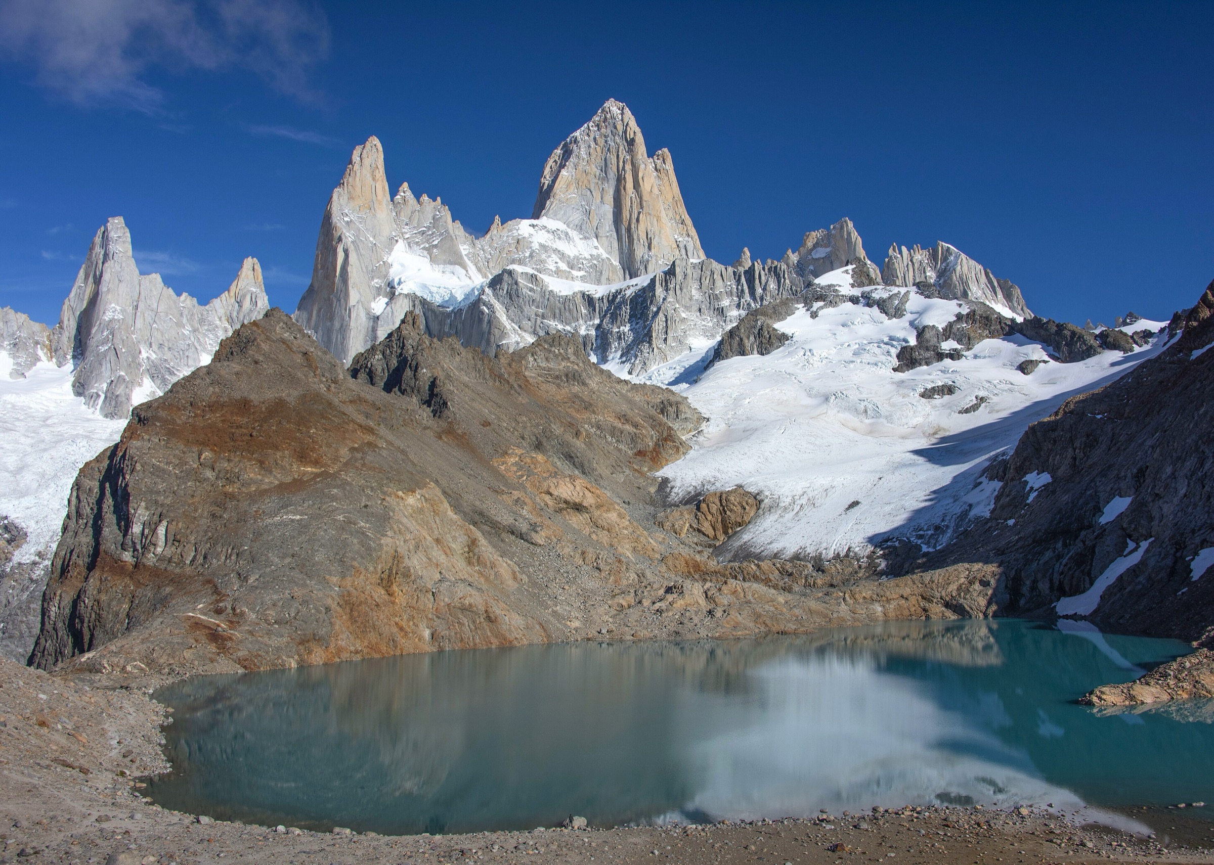
This point-to-point variant starts north of El Chaltén near the Río Eléctrico / El Pilar access area and follows the Fitz Roy approach through forest and open valley terrain. The route passes the Río Blanco / Piedras Blancas side of the massif, reaches the Poincenot and Río Blanco sector, then climbs the steep final moraine slope of about 400 m to Laguna de los Tres. The reward is the closest non-technical day-hike viewpoint below Fitz Roy, with Laguna de los Tres, Glaciar de los Tres and the granite spires directly ahead.
The descent follows the main Senda al Fitz Roy back toward El Chaltén, with the option to pass the Laguna Capri junction before entering the final descending path to the village. AllTrails records the El Pilar - Laguna de los Tres - El Chaltén line as 21.7 km point-to-point with 959 m of ascent. The official El Chaltén description of the town-start route gives 8-9 hours and describes the final steep section from Río Blanco to the lagoon.
Why it is essential
Laguna de los Tres is the definitive Fitz Roy day hike. The El Pilar / Río Eléctrico version adds the Piedras Blancas side of the massif and avoids repeating the same approach, giving a fuller traverse of the classic Fitz Roy walking terrain in one day.
Equipment
Sturdy hiking footwear, waterproof and windproof shell, warm layer, hat and gloves, sun protection, 2 litres or more of water, food for a long day, headtorch, offline map/GPS and trekking poles for the final moraine and descent. Microspikes may be needed outside normal summer conditions.
Hazards and notes
The final climb to Laguna de los Tres is steep, eroded and exposed to wind. Snow, ice, poor visibility and strong gusts can make the upper slope unsafe. The route has no services once on trail. Access through private El Pilar facilities has changed in recent years; walkers should confirm the legal start point and transfer drop-off locally. Dogs are listed as not allowed by AllTrails.
GPX / KML links
| Source | URL | Format / access | Reuse status |
|---|---|---|---|
| AllTrails: El Pilar - Laguna de Los Tres - El Chaltén | alltrails.com | Source map / downloadable route via AllTrails account | AllTrails terms apply; direct GPX not retrieved; source-map reference only |
| OpenStreetMap search: Laguna de los Tres | openstreetmap.org | Map geometry cross-check | OSM data is ODbL; geometry cross-check target only |
External links
- El Chaltén official trail page — Laguna de los Tres
- AllTrails — El Pilar - Laguna de Los Tres - El Chaltén
2. Laguna Torre and Cerro Torre viewpoint
Snapshot
Itinerary
From El Chaltén, two signed trailheads merge shortly after leaving town and follow the Fitz Roy river valley toward the Cerro Torre massif. The early section climbs to a viewpoint over the valley, then continues through lenga forest, moraine terrain and open flats toward De Agostini camp and Laguna Torre. The lake sits below Cerro Torre, Torre Egger, the Adela range and the glacier-fed basin that often holds floating ice.
The standard day-hike turns around at Laguna Torre. Fit parties sometimes continue along the rougher moraine to Mirador Maestri for a higher view across the glacier and lake; that extension is more exposed to wind and is not included in the AllTrails 18.0 km figure used here.
Why it is essential
Laguna Torre is the classic Cerro Torre day approach and the necessary counterpart to Laguna de los Tres. It shows the other great granite group of El Chaltén, with a more gradual valley profile and a direct glacial-lake finish.
Equipment
Sturdy shoes or boots, waterproof/windproof shell, insulating layer, food, water, sun protection, gloves and hat, offline map/GPS and headtorch. Trekking poles are useful on wet or loose moraine, especially if continuing toward Mirador Maestri.
Hazards and notes
Wind can be severe around Laguna Torre and on the moraine. Rain, mud, snow patches and poor visibility are common. The optional Mirador Maestri extension should be treated as a rougher, more exposed add-on. Dogs are listed as not allowed by AllTrails.
GPX / KML links
| Source | URL | Format / access | Reuse status |
|---|---|---|---|
| AllTrails: Torre Lagoon | alltrails.com | Source map / downloadable route via AllTrails account | AllTrails terms apply; direct GPX not retrieved; source-map reference only |
| OpenStreetMap search: Laguna Torre | openstreetmap.org | Map geometry cross-check | OSM data is ODbL; geometry cross-check target only |
External links
3. Loma del Pliegue Tumbado
Snapshot
Itinerary
The trail starts near the national-park visitor centre, where the path toward Pliegue Tumbado and Laguna Toro separates from the shorter Condores / Águilas viewpoint trails. It climbs through open ground and lenga forest, crosses Pampa de las Carretas, then rises above the tree line onto increasingly open and windy slopes. The marked viewpoint gives a broad panorama over Fitz Roy, Cerro Torre, Laguna Torre, the Río Fitz Roy valley, Lago Viedma and the southern approaches to the massif.
The official El Chaltén page notes that the last section fades but is marked with yellow posts. It also describes an optional continuation to the summit requiring another hour and about 280 m of additional ascent from the viewpoint. The AllTrails route used for the summary records 19.3 km out-and-back with 1,134 m of gain.
Why it is essential
Loma del Pliegue Tumbado is the best all-massif balcony above El Chaltén. Unlike the valley routes to Fitz Roy and Cerro Torre, it rises onto a separate ridge and shows both groups in a single panorama, making it essential for geographic understanding of the region.
Equipment
Mountain day-hiking kit: sturdy footwear, waterproof and windproof shell, warm layers, gloves, hat, sun protection, food, 2 litres or more of water, GPS/offline map and headtorch. Trekking poles are useful on the long descent. Carry extra insulation because the upper slope is fully exposed.
Hazards and notes
The route is long, continuously ascending and highly exposed above the forest. Strong wind, snowfall, whiteout, wet ground and cold can occur even in summer. The summit extension is steeper and less distinct than the main viewpoint approach. Dogs are listed as not allowed by AllTrails.
GPX / KML links
| Source | URL | Format / access | Reuse status |
|---|---|---|---|
| AllTrails: Loma del Pliegue Tumbado | alltrails.com | Source map / downloadable route via AllTrails account | AllTrails terms apply; direct GPX not retrieved; source-map reference only |
| OpenStreetMap search: Loma del Pliegue Tumbado | openstreetmap.org | Map geometry cross-check | OSM data is ODbL; geometry cross-check target only |
External links
4. Laguna Capri / Mirador Fitz Roy
Snapshot
Itinerary
The route follows the main Senda al Fitz Roy from the north end of El Chaltén. After an initial ascent, it reaches views over the Río de las Vueltas valley and continues through forest and open viewpoints toward the Fitz Roy massif. A signed junction leads to Laguna Capri, where the shoreline gives a classic low-elevation view of Fitz Roy reflected in the lake in calm weather.
The walk returns to El Chaltén by the same route. It can be treated as a shorter independent hike or as the lower portion of the longer Laguna de los Tres approach.
Why it is essential
Laguna Capri is the most important shorter Fitz Roy walk from El Chaltén. It provides a genuine massif viewpoint and lake setting without the long day and steep final moraine required for Laguna de los Tres.
Equipment
Standard hiking footwear, rain/wind shell, warm layer, water, snacks, sun protection and offline map. In shoulder seasons, add gloves, hat and traction if snow or ice is present.
Hazards and notes
The first climb from town can be slippery in rain or snow. Weather can obscure Fitz Roy completely, so the scenic value depends heavily on cloud. Stay on marked paths around the lake and campsites. Dogs are listed as not allowed by AllTrails.
GPX / KML links
| Source | URL | Format / access | Reuse status |
|---|---|---|---|
| AllTrails: Laguna Capri | alltrails.com | Source map / downloadable route via AllTrails account | AllTrails terms apply; direct GPX not retrieved; source-map reference only |
| OpenStreetMap search: Laguna Capri | openstreetmap.org | Map geometry cross-check | OSM data is ODbL; geometry cross-check target only |
External links
5. Chorrillo del Salto from El Chaltén
Snapshot
Itinerary
From the north side of El Chaltén, the route follows the signed path toward Chorrillo del Salto, briefly using the area near the Lago del Desierto road before entering low ñire and lenga forest. The last section is foot-only and nearly flat, ending at the waterfall where Arroyo del Salto drops more than 20 m before flowing toward the Río de las Vueltas.
The route can also be shortened by driving or cycling to the parking area near the final footpath, but the full walk from town is the better catalogue version because it is car-free and gives a complete low-level approach.
Why it is essential
Chorrillo del Salto is El Chaltén’s essential short forest-and-waterfall walk. It balances the catalogue by adding an accessible objective for poor weather, arrival day, families and recovery after the longer mountain routes.
Equipment
Comfortable walking shoes or light hiking footwear, rain jacket, warm layer, water and sun protection. In winter or freeze-thaw conditions, traction may be useful near the waterfall.
Hazards and notes
The route is simple but can be muddy, icy or busy. Bicycles are not allowed on the final foot-only section described by the official trail page. Dogs are listed as not allowed by AllTrails.
GPX / KML links
| Source | URL | Format / access | Reuse status |
|---|---|---|---|
| AllTrails: Chorillo del Salto | alltrails.com | Source map / downloadable route via AllTrails account | AllTrails terms apply; direct GPX not retrieved; source-map reference only |
| OpenStreetMap search: Chorrillo del Salto | openstreetmap.org | Map geometry cross-check | OSM data is ODbL; geometry cross-check target only |
External links
External links
| Source | URL |
|---|---|
| El Chaltén official self-guided trail pages | elchalten.com |
| Parque Nacional Los Glaciares activities — Argentina National Parks | argentina.gob.ar |
| AllTrails — El Chaltén trail pages | alltrails.com |
| AllTrails — El Pilar - Laguna de Los Tres - El Chaltén | alltrails.com |
| AllTrails — Torre Lagoon | alltrails.com |
| AllTrails — Loma del Pliegue Tumbado | alltrails.com |
| AllTrails — Laguna Capri | alltrails.com |
| AllTrails — Chorillo del Salto | alltrails.com |