Regional overview
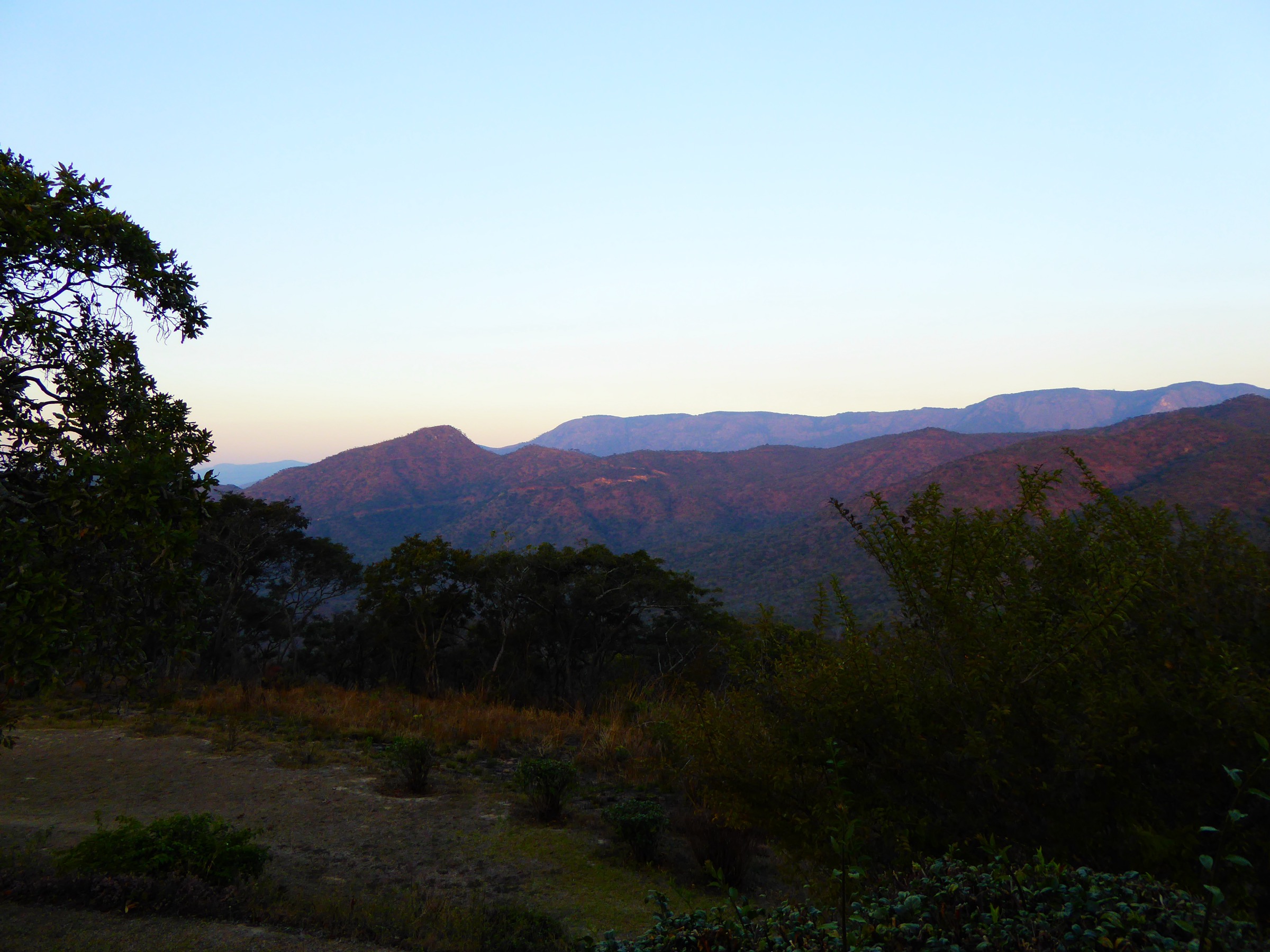
The Nyanga Mountains form the northern section of Zimbabwe’s Eastern Highlands, a 300 km cordillera shared with Mozambique that also includes the Bvumba and Chimanimani further south. The Nyanga sub-region is defined by a high, rolling montane plateau between roughly 1,800 m and 2,300 m, dropping abruptly over a 600–800 m escarpment into the Honde Valley to the east. Almost all of the walking takes place inside the 47,000-hectare Nyanga National Park, administered by the Zimbabwe Parks and Wildlife Management Authority (ZimParks), with the adjacent Mutarazi Falls National Park (2,495 ha) covering the Honde escarpment. Mount Nyangani (2,592 m) is Zimbabwe’s highest peak; Mutarazi Falls (762 m) is its tallest waterfall and one of the highest in Africa.
Hiking is concentrated around four staging points: the main park headquarters at Rhodes Camp / Rhodes Dam (the cluster of Cecil Rhodes’ old farm buildings, now a museum), Mare Dam in the centre of the park, the Mount Nyangani trailhead car park on the Circular / Scenic Road, and the Mtarazi Falls car park on the southern boundary. The village of Juliasdale on the A14 is the usual road approach from Harare (about 270 km, four to five hours by car); Troutbeck Inn on the northern plateau is the base for World’s View. Terrain is mostly open, treeless montane grassland on the plateau, with miombo woodland and stands of indigenous afromontane forest in the gorges and along streams. Granite domes and tors break the plateau, and the Pungwe, Mare and Nyangombe rivers drain east and south through deep gorges.
The dry, cool season (May to August) is the established hiking season: clear air, brown grass, daytime temperatures of 15–22 °C and frosty nights at altitude. September to early November is warm and increasingly hazy with bushfire smoke. The rainy season (mid-November to March) brings violent thunderstorms, thick orographic cloud and very slippery rock; total annual rainfall on the higher slopes is around 2,200 mm. Mount Nyangani has a well-documented reputation for rapid weather change — sun to dense fog within minutes — and several hikers have died over the decades after losing the path in cloud, so the summit is treated locally as a serious mountain rather than a casual walk. Visibility-driven hazard, river crossings after rain, and slippery rock at waterfalls are the main objective risks; there is no large dangerous wildlife on the high plateau, but leopard and baboon are present.
Access is by private vehicle. Park entry fees apply at the main ZimParks gate near Rhodes Camp and a separate fee at Mtarazi Falls and at the National Trust of Zimbabwe gate for World’s View. Internal park roads were significantly degraded after years of underfunding; a high-clearance vehicle is recommended and 4WD becomes essential on the Pungwe/Honde scenic road in wet conditions. Public transport in the area is limited to long-distance buses and shared minibuses (kombis) along the A14; reaching trailheads inside the park requires a private car, a tour, or a lift from one of the lodges.
Selection rationale
Five hikes were chosen to span the headline features of the Nyanga Mountains and to remain plausible day-walks for fit, unguided visitors:
- Mount Nyangani Tourist Path — the iconic summit, Zimbabwe’s roof.
- Mtarazi Falls and Honde View walk — the great Honde escarpment edge and Zimbabwe’s highest waterfall.
- Pungwe Gorge / Pungwe View walk from the Scenic Road — the most dramatic gorge view on the plateau.
- Nyangombe Falls short walk and river circuit — the accessible riverine waterfall walk near park HQ, suitable for almost everyone.
- World’s View, Troutbeck — the classic plateau-edge viewpoint with the optional ridge-top scramble above the toposcope.
A Mare Dam circuit was considered but cannot be confirmed from a recognised official trail description (only general references to “walks around the dam” appear in tourism literature), so it has been replaced by World’s View, which is both historically significant and walkable.
Summary table
| # | Hike | Country | Route type | Distance | Gain | Max elevation | Difficulty |
|---|---|---|---|---|---|---|---|
| 1 | Mount Nyangani Tourist Path | Zimbabwe | Out-and-back | 8–9 km | ~400 m | 2,592 m | Moderate |
| 2 | Mtarazi Falls and Honde View escarpment walk | Zimbabwe | Out-and-back / variant loop | 1.2–8 km | 50–250 m | ~1,860 m | Easy to moderate |
| 3 | Pungwe Gorge view and Pungwe Drift walk | Zimbabwe | Out-and-back | 2–5 km | ~150 m | ~1,900 m | Easy to moderate |
| 4 | Nyangombe Falls and natural pool walk | Zimbabwe | Short loop / out-and-back | 1–2 km | ~50 m | ~1,820 m | Easy |
| 5 | World’s View, Troutbeck | Zimbabwe | Short out-and-back / optional ridge | 0.5–2 km | 50–120 m | ~2,300 m | Easy |
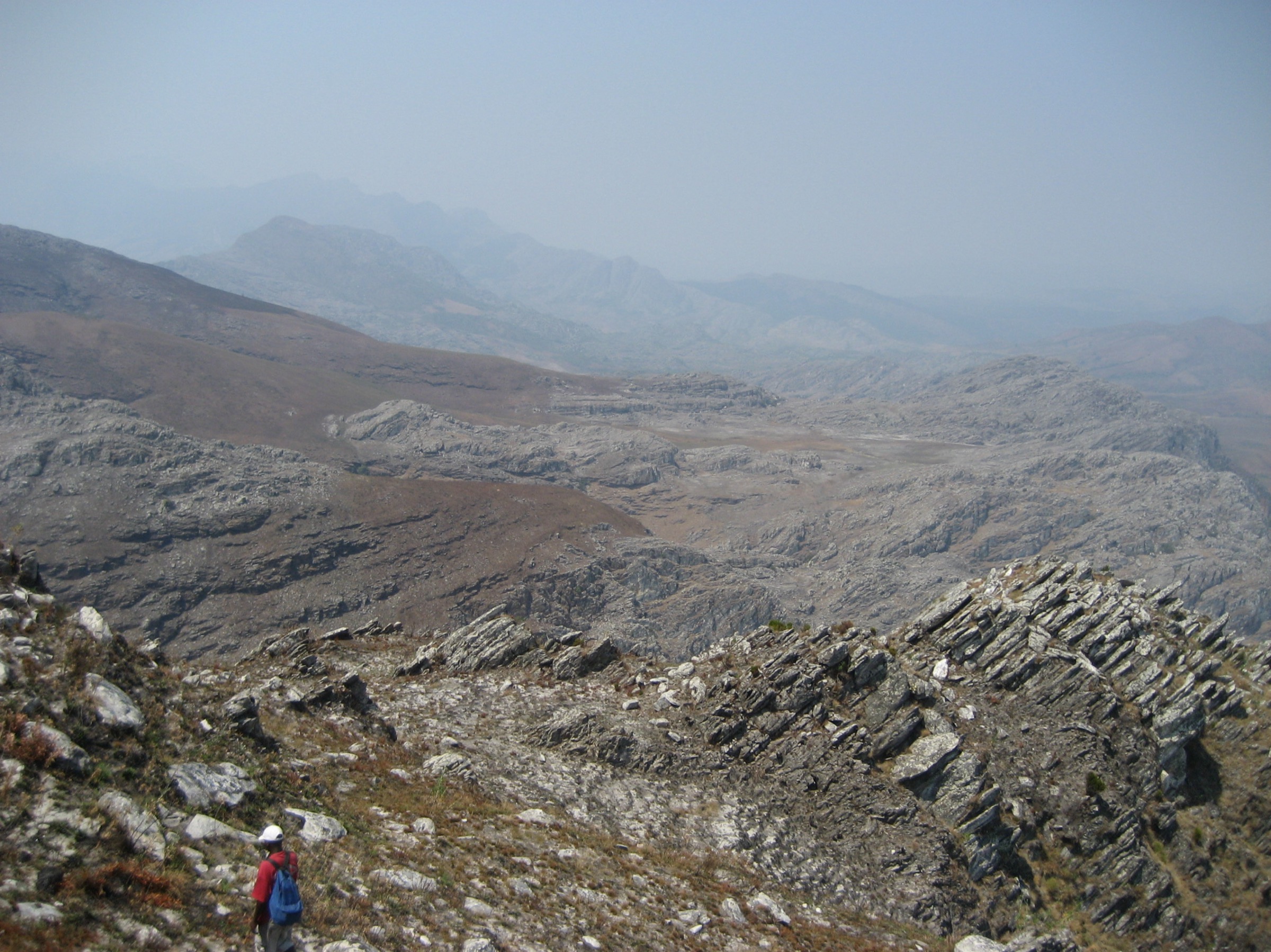
1. Mount Nyangani Tourist Path


Snapshot
Itinerary
The Tourist Path leaves the small ZimParks car park on the Scenic Road (also called Circular Drive), where a signboard records the route and the names of hikers lost on the mountain. The path climbs steeply through tussock grassland and small protea stands along the western flank, following the line of the upper Nyamuziwa River, with two streams crossed by the time the route reaches the lip of the plateau at about 2,200 m. A line of cairns and short marker posts continues across the gently undulating summit plateau, generally trending south-east and then south. The plateau is studded with quartzite tors, small bogs and turf hags, and the actual summit is a low rocky rise marked by a concrete trig beacon and a survey cairn. The return follows the same line; in good visibility, the descent to the car park is straightforward, but in cloud the descent point from the plateau is easy to miss and parties have gone astray to the north and east.
Two alternative ascents exist for reference: the Mountain Club of Zimbabwe Route on the east side of the northern ridge, joining the Tourist Path on the plateau, and the Nyazengu Route from the south via Tucker’s Gap through an unmarked boulder field. Neither is recommended for first-time visitors.
Why it is essential
Mount Nyangani is the highest point in Zimbabwe and the obvious summit objective of the Eastern Highlands. The Tourist Path is the only route that is both signposted and feasible without local guidance in clear weather, and the open plateau gives long views east into Mozambique and west across the Nyanga Downs.
Equipment
Mountain hiking equipment: sturdy boots, full waterproofs, warm layer (frost possible at the summit even in winter), hat and gloves outside midsummer, navigation backup (paper map and compass plus GPS), headtorch, food and at least 1.5 L of water. A whistle is sensible. There is no shelter on the plateau.
Hazards and notes
Rapid weather change is the principal hazard: clear conditions can switch to dense hill fog within minutes, reducing visibility to under 50 m. Multiple hikers have died on the mountain after losing the path in cloud, falling into ravines on the eastern side, or hypothermia. ZimParks asks parties to sign in and out at the car park register. The route should not be attempted alone, in cloud, or with cloud building. Local belief considers the mountain sacred and there is a long-standing local convention not to point at it or speak loudly on the summit. There is no water on the plateau; collecting from the Nyamuziwa is possible low down but requires treatment. Park entry fee applies.
Routes and maps
| Source | URL | Format | Reuse status |
|---|---|---|---|
| OpenStreetMap — Mount Nyangani area paths | openstreetmap.org | OSM data (Overpass extractable as GeoJSON/GPX) | ODbL 1.0; reusable with attribution; path geometry on OSM is partial and should be field-checked |
| Wikiloc — community tracks for Nyanga, Manicaland | wikiloc.com | GPX (per-track) | Per-uploader; download requires account; coordinate sequences usable as factual data |
No official ZimParks GPX could be located.
External links
- en.wikipedia.org — Wikipedia: Mount Nyangani
- zimfieldguide.com — Zimbabwe Field Guide: Mount Nyangani
- zimparks.org.zw — ZimParks: Nyanga National Park
- summitpost.org — SummitPost: Nyangani
- peakvisor.com — PeakVisor: Mount Nyangani
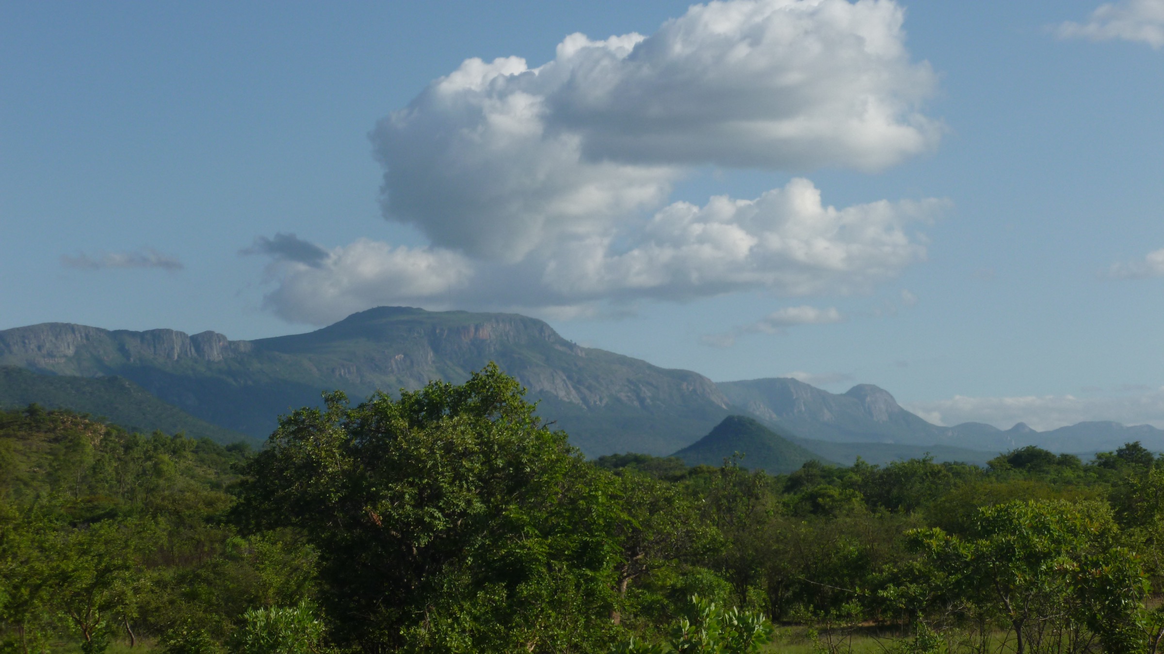
2. Mtarazi Falls and Honde View escarpment walk

Snapshot
Itinerary
From the Mutarazi Falls National Park car park, a level track leads roughly 600 m through montane heath and protected mountain forest to the upper escarpment rim, where two railed viewpoints look down on the falls and out over the Honde Valley some 760 m below. The water of the Mtarazi River drops in two near-continuous tiers down the eastern face of the Nyanga escarpment, with a total drop of 762 m — Zimbabwe’s highest waterfall.
The longer walk continues north-east along the lip of the escarpment, threading between protea, ericaceous heath and pockets of yellowwood forest, to Honde View, a separate prominent buttress with an open panorama down the full length of the Honde Valley and across to the Mozambican border. The path is generally well-trodden and unexposed, but the cliff edge is unfenced and steps and roots are slippery in wet weather. The viewpoint route can be linked with Pungwe View further north for a full escarpment day, but most parties treat Mtarazi and Pungwe as separate short walks rather than a connected traverse, since the scenic road in between is degraded.
Why it is essential
The view from the top of the Mtarazi escarpment is the single biggest set-piece of the Nyanga side of the Eastern Highlands: the height of the waterfall, the cliffline and the contrast between the cool plateau grassland and the hot subtropical Honde Valley below are all defining features of the region. The walk is accessible to almost any visitor, which makes it the natural complement to the Nyangani summit day.
Equipment
Standard hiking equipment: walking shoes or light boots, a weatherproof layer (the rim can be cold and wet even when the valley is hot), water, sun protection. Trekking poles useful for the longer escarpment variant if conditions are wet.
Hazards and notes
The cliff edge is largely unfenced; supervise children closely. Wet rock and mossy steps near the railed viewpoint are very slippery. The Skyline Zipline / Mutarazi Skywalk attraction operates separately from the public viewpoint walk and has its own fee. The Mtarazi gate charges its own entrance fee in addition to any Nyanga National Park fee paid earlier. Cellular coverage is patchy on the rim. In thick cloud the viewpoint walk loses its purpose and the cliff edge becomes much more dangerous.
Routes and maps
| Source | URL | Format | Reuse status |
|---|---|---|---|
| OpenStreetMap — Mutarazi Falls viewpoint paths | openstreetmap.org | OSM data | ODbL 1.0; reusable as factual coordinates with attribution |
No official ZimParks GPX could be located; no Wikiloc track for the Mtarazi escarpment-edge walk was confirmed in this pass.
External links
- zimfieldguide.com — Zimbabwe Field Guide: Mutarazi Falls National Park
- en.wikipedia.org — Wikipedia: Mutarazi Falls
- zimparks.org.zw — ZimParks: Nyanga National Park
- zimbabwetourism.net — Zimbabwe Tourism Authority: Mtarazi Falls
- nyati-travel.com — Nyati Travel: Walking Trails (Mutarazi)
3. Pungwe Gorge view and Pungwe Drift walk


Snapshot
Itinerary
The Pungwe View is a railed viewpoint on the edge of the Scenic Road where the Pungwe River drops 240 m in tiered cascades into a deeply wooded gorge. From the small car park, a short level path of around 100 m leads to the lookout itself, with a long panorama south-east into the Pungwe Gorge and across to the Nyazengu River drainage. To turn this into a proper short walk, a longer option is to continue along the gravel Scenic Road downhill towards Pungwe Drift, where the river is crossed by a low concrete causeway — a round trip of roughly 4–5 km depending on the start point, with a steady descent on the way out and the corresponding climb on return.
Below the drift, an unmaintained footpath enters the Pungwe Gorge rainforest. This is not a marked tourist path, descends steeply and can only be safely followed with local guidance.
Why it is essential
The Pungwe Gorge is the most dramatic of the plateau-edge incisions on the Nyanga side, and the only one where the visitor can stand in the gorge itself (at the drift) as well as looking down into it from the rim. The contrast between the open grassland of the plateau and the closed-canopy submontane forest in the gorge is one of the most rapid ecological gradients in the Eastern Highlands.
Equipment
Standard hiking equipment: walking shoes, weatherproof layer, water, sun protection. Trekking poles helpful for the descent to the drift on the loose gravel road.
Hazards and notes
The Pungwe Drift causeway is impassable in flood; do not attempt to cross when the river is high. The Scenic Road has degraded badly and is now best driven only in a high-clearance or 4WD vehicle. The gorge floor below the drift is reported in tourism sources as not safe to enter alone and is recommended only with a local guide. Park entry fee applies. There is no cellular coverage in the gorge.
Routes and maps
| Source | URL | Format | Reuse status |
|---|---|---|---|
| OpenStreetMap — Pungwe Falls / Scenic Road | openstreetmap.org | OSM data | ODbL 1.0; reusable as factual coordinates with attribution |
No GPX could be located on Wikiloc or any official ZimParks portal in this pass.
External links
- zimfieldguide.com — Zimbabwe Field Guide: Pungwe Falls
- moscom.co.za — Nyanga National Park area guide: Pungwe Falls and Gorge
- zimbabwetourism.net — Zimbabwe Tourism Authority: Pungwe Falls
- zimparks.org.zw — ZimParks: Nyanga National Park
4. Nyangombe Falls and natural pool walk

Snapshot
Itinerary
The path leaves the Nyangombe car park and camping ground, in the south-western corner of the park, and drops gently for about 300 m to the lip of a granite slab where the Nyangombe River steps down through a series of cascades and small chutes. A short rock scramble continues down-river to the main pool at the foot of the falls, locally known as Brighton Beach for its sandy fringe. The descent involves smooth granite slabs that are extremely slippery when wet. A short loop continues along the right bank for a few hundred metres to additional viewpoints over the river before doubling back to the car park.
The walk can be extended upstream towards the Nyangombe campsite picnic area, but there is no formal long-distance trail along the river inside the park boundary.
Why it is essential
This is the most accessible riverine walk in Nyanga, and the natural pool is reported by ZimParks and local guides to be bilharzia-free and safe for swimming — a rarity in lowland Africa. It complements the long summit and escarpment days with a short, low-altitude walk that almost any visitor can complete.
Equipment
Standard hiking equipment: walking shoes with good grip (rock can be very slippery), sun protection, water, swimsuit and towel if intending to swim.
Hazards and notes
The granite slabs near the falls are very slippery, especially in mist or just after rain, and falls into the river have caused injuries. Do not attempt to swim immediately above the lip of the cascades; the current is strong and the drop is unforgiving. Camping is permitted at the adjacent ZimParks site. Park entry fee applies.
Routes and maps
| Source | URL | Format | Reuse status |
|---|---|---|---|
| OpenStreetMap — Nyangombe Falls area | openstreetmap.org | OSM data | ODbL 1.0; reusable as factual coordinates with attribution |
No official ZimParks GPX could be located.
External links
- zimfieldguide.com — Zimbabwe Field Guide: Nyangombe Natural Swimming Pool / Falls
- zimbabwetourism.net — Zimbabwe Tourism Authority: Nyangombe Falls
- zimparks.org.zw — ZimParks: Nyanga National Park
- easternhighlander.com — Eastern Highlander: Nyangombe Falls field report
5. World’s View, Troutbeck
Snapshot
Itinerary
The site is reached by a single-track gravel road that climbs about 11 km from Troutbeck to a small National Trust of Zimbabwe gate and a low stone office. From the car park a level path of around 200 m leads to the principal viewpoint, where a stone tower carries a toposcope: thirty African localities are inscribed on black-granite slabs giving direction and distance. The escarpment falls some 600 m sheer to the west, with views on a clear day reported to extend 60–70 km, taking in the Little Connemara Lakes immediately below and the Nyanga Downs plateau to the south.
For walkers, a steeper informal path continues uphill behind the toposcope to a higher rocky vantage, about 30 to 40 minutes round-trip from the gallery, where the panorama opens to include the Connemara dams and the line of the escarpment more fully. The rock requires care but no technical scrambling.
Why it is essential
World’s View is the classic plateau-edge viewpoint of the Nyanga Downs and the highest point in Zimbabwe reachable by road. The toposcope is a long-standing piece of regional heritage, and the optional walk above it gives the best one-stop overview of the Nyanga plateau, the Connemara lakes country and the long western escarpment.
Equipment
Standard hiking equipment for the short walks: walking shoes, weatherproof layer (the rim is consistently colder and windier than Troutbeck below), sun protection, water. No special kit required.
Hazards and notes
The west-facing escarpment is a sheer cliff and is unfenced beyond the tower; supervise children. The 11 km access track from Troutbeck is rutted and gullied and requires 4WD in wet weather. Entry is collected at the National Trust of Zimbabwe gate (a small fee, separate from Nyanga National Park). The site has a small gallery, opened in 2012, and is managed by the National Trust of Zimbabwe across approximately 70 hectares.
Routes and maps
| Source | URL | Format | Reuse status |
|---|---|---|---|
| OpenStreetMap — World’s View, Nyanga | openstreetmap.org | OSM data | ODbL 1.0; reusable as factual coordinates with attribution |
No official GPX from the National Trust of Zimbabwe could be located.
External links
- en.wikipedia.org — Wikipedia: World’s View, Nyanga
- ntoz.org — National Trust of Zimbabwe: World’s View
- zimfieldguide.com — Zimbabwe Field Guide: World’s View, Nyanga
- en.wikipedia.org — Wikipedia: Troutbeck, Manicaland
Outstanding verification notes
- No official ZimParks GPX/KML downloads exist for any of the five hikes. OpenStreetMap geometry around Mount Nyangani, Mtarazi Falls, Pungwe View, Nyangombe Falls and World’s View is partial and needs to be field-verified before any derived GPX is published.
- No licence-compatible photo for World’s View / Troutbeck was located in this pass. A focused search on Flickr Creative Commons and Wiki Loves Africa entries is required.
- Two of the open-licensed Wikimedia Commons photos of Mount Nyangani (Nyangani from nyamuziwa source.jpg, Nyangani south end.jpg) are only 900 × 600 px and fall below the project’s hard 2,000 px floor for cover use; usable only as inline figures.
- The “Mtarazi Falls escarpment walk” is reported in tourism sources with widely varying distances (some quote a 600 m car-park walk, others a 15 km full-day walk passing Honde View). The figures given here use the most consistent range; a ZimParks signboard or current National Park map would resolve this definitively.
- Mare Dam was excluded from the final five because no clearly described circuit route (with distance, gain or trail status) could be confirmed from a recognised source. A locally guided walk would be needed to specify a publishable route.
- Mount Nyangani trailhead coordinates and elevations should be confirmed on the ground; the values given here are derived from OSM and Wikipedia and may be approximate to within ~100 m.
- Park entry fees, opening hours and current road condition on the Scenic Road (especially towards Pungwe Drift and Mtarazi) change frequently and should be reconfirmed close to publication.
- Local cultural protocols on Mount Nyangani (the convention of not pointing at the summit, etc.) are reported consistently in field-guide sources but should be cross-checked with a current ZimParks briefing.
External links
| Source | URL |
|---|---|
| Zimbabwe Parks and Wildlife Management Authority — Nyanga National Park | zimparks.org.zw |
| Zimbabwe Tourism Authority — Nyanga / Mtarazi / Pungwe / Nyangombe portfolios | zimbabwetourism.net |
| Wikipedia: Mount Nyangani | en.wikipedia.org |
| Wikipedia: Nyanga National Park | en.wikipedia.org |
| Wikipedia: Mutarazi Falls | en.wikipedia.org |
| Wikipedia: World’s View, Nyanga | en.wikipedia.org |
| Wikipedia: Honde Valley | en.wikipedia.org |
| Zimbabwe Field Guide — Nyanga National Park and sub-pages | zimfieldguide.com |
| SummitPost — Nyangani | summitpost.org |
| PeakVisor — Mount Nyangani / Nyanga | peakvisor.com |
| National Trust of Zimbabwe — World’s View | ntoz.org |
| Wikivoyage — Nyanga National Park | en.wikivoyage.org |
| Wikiloc — Nyanga, Manicaland | wikiloc.com |
| Wikimedia Commons — Category: Mount Nyangani | commons.wikimedia.org |
| Wikimedia Commons — Category: Nyanga National Park | commons.wikimedia.org |