Regional overview
The Ardennes, Eifel and Hunsrück form a low-mountain belt of forested plateaux, deeply cut river valleys, sandstone and slate gorges, reservoir landscapes, and historic villages across Belgium, Luxembourg and western Germany. The region is lower than the Alps or Pyrenees, but its best hikes are often rugged: narrow stream paths, slippery rock steps, gorge crossings, ladders, and steep woodland descents are common.
The main hiking centres represented here are Aywaille in the Belgian Ardennes, Berdorf and the Mullerthal sandstone country in Luxembourg, the South Eifel around Ernzen and the Teufelsschlucht, the Eifel National Park corridor between Einruhr and Gemünd, and the Hunsrück gorge country around the Baybachklamm.
The normal hiking season is spring to autumn. Many routes can be walked outside this period, but ice, wet leaves, high water, and short daylight can make gorge and rock routes significantly more serious. No technical climbing equipment is normally required for the selected routes, but grippy footwear and confident movement on wet or uneven ground are important.
Selection rationale
These five hikes were selected to represent the region’s core walking character: an Ardennes stream gorge, a Luxembourg sandstone-and-cave circuit, a South Eifel rock-and-gorge premium trail, a long Eifel National Park traverse, and a Hunsrück slate gorge route. The selection balances scenic value, official recognition, geographic spread, and availability of verifiable route information.
Summary table
| # | Hike | Country | Route type | Distance | Gain | Max elevation | Difficulty |
|---|---|---|---|---|---|---|---|
| 1 | Ninglinspo AY21 — Vallon du Ninglinspo and Point de Vue Drouet | Belgium | Loop | 6.0–6.22 km | 231–268 m | 385 m | Moderate / rugged stream path |
| 2 | Auto-Pédestre Berdorf — Perekop and Huel Lee | Luxembourg | Loop | 6.6 km | Not separately stated | 375 m | Moderate; ladders and rock paths |
| 3 | Felsenweg 6 — Teufelsschlucht | Germany | Loop | 17.4 km | 440 m | 362 m | Medium / moderate, but long and rocky |
| 4 | Eifelsteig Stage 4 — Einruhr to Gemünd | Germany | Point-to-point | 21.2 km | 574 m | 522 m | Medium; strenuous because of length |
| 5 | Traumschleife Baybachklamm | Germany | Loop | 10.46–10.5 km | 366–413 m | 354 m | Hard |
Note on route files. Route links are source references and may be replaced with project-owned GPX/KML files later.
1. Ninglinspo AY21 — Vallon du Ninglinspo and Point de Vue Drouet
Snapshot
Itinerary
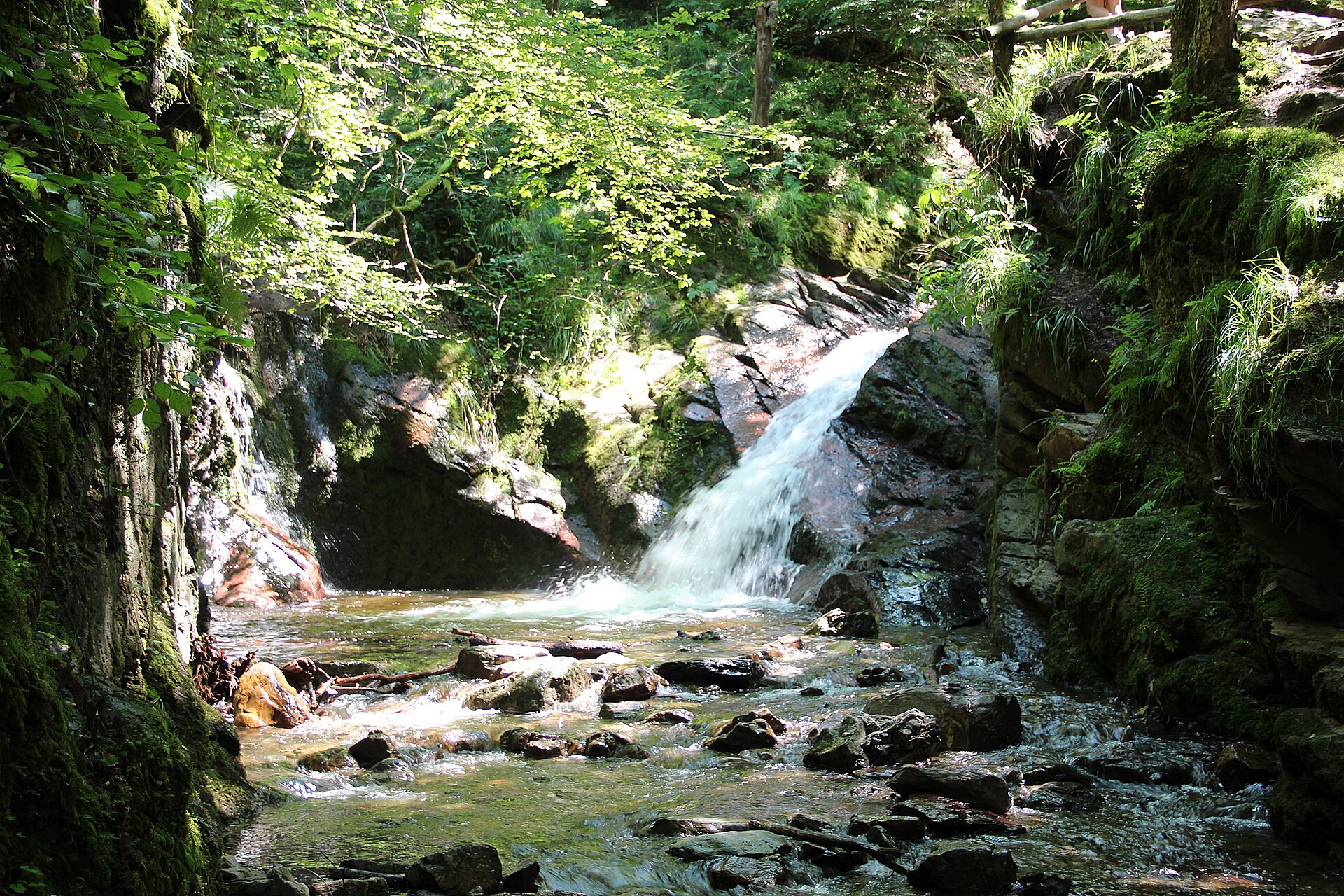
The route starts at Sedoz and follows the blue-rectangle waymarking into the Ninglinspo valley. The path follows Belgium’s only officially named mountain stream, crossing small bridges and passing cascades, pools, rock basins, and wooded slopes. The walk climbs through the stream valley before reaching higher woodland and the Point de Vue Drouet area, then returns towards Sedoz.
Why it is essential
This is one of the defining short hikes of the Belgian Ardennes: compact, scenic, and unusually rugged for the region. The combination of stream gorge, woodland, waterfalls, and rock pools makes it a strong representative of Ardennes valley hiking.
Equipment
- Hiking shoes or boots with good grip
- Weatherproof layer
- Warm layer outside summer
- Water and food
- Map or GPS
- Sun protection
- Trekking poles useful on wet woodland descents
- Tick protection recommended
Hazards and notes
- Wet rock
- Narrow streamside paths
- Wooden bridges
- Mud
- Icy winter conditions
- Avoid during high water or after severe weather
GPX / KML links
| Source | URL | Format | Notes |
|---|---|---|---|
| VisitOVA / VISITWallonia route download | visitova.be | GPX | Terms not clearly stated. Route file found; reuse and attribution status unresolved. Replace with project-owned GPX later. |
| Cirkwi / VISITWallonia source route | cirkwi.com | Source map / GPX download | Platform and tourism terms not fully checked. Usable as source route; reuse status unresolved. |
Further reading
- VisitWallonia — Walk along the Ninglinspo valley
- VisitOVA — Ninglinspo
- Cirkwi — Aywaille AY21 Vallon du Ninglinspo
2. Auto-Pédestre Berdorf — Perekop and Huel Lee
Snapshot
Itinerary
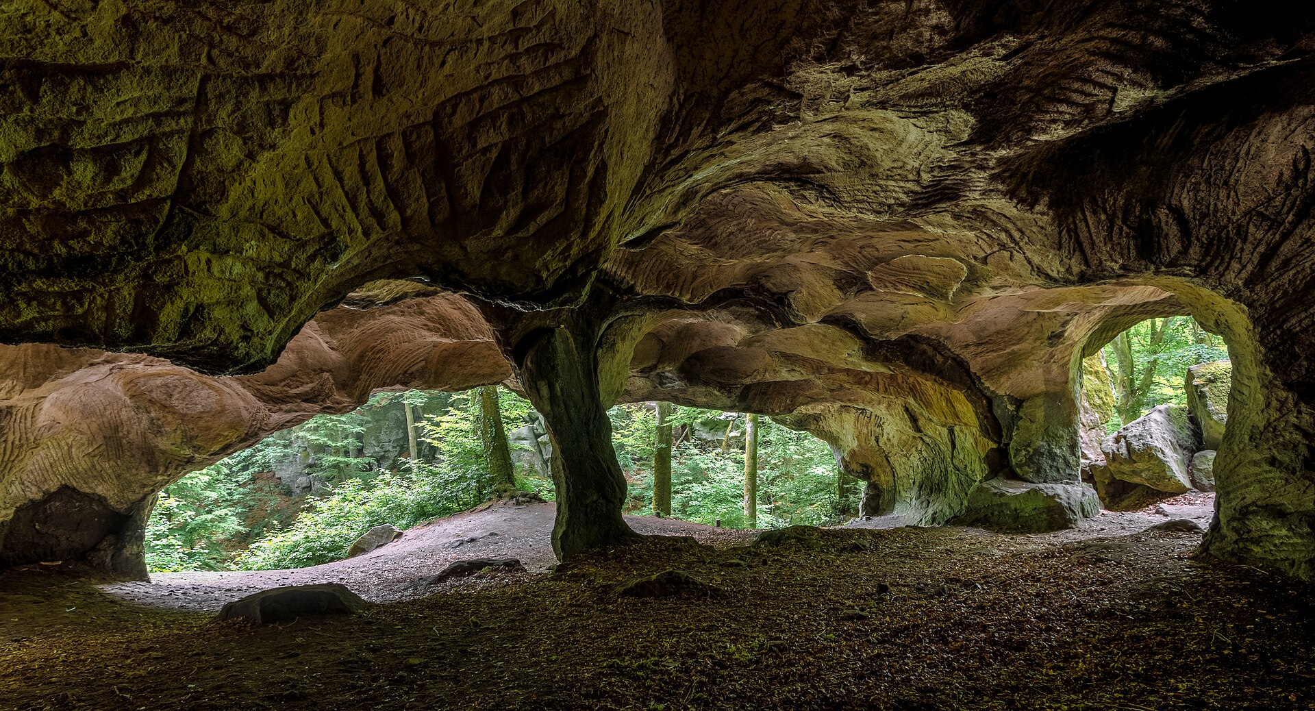
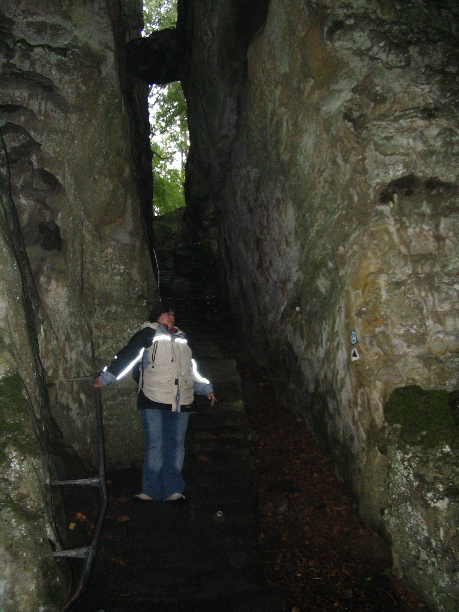
The official circular walk starts in Berdorf and descends into the sandstone rock landscape of the Mullerthal. The route passes the Perekop formation, where steps and a ladder lead through a narrow rock passage, then continues to Huel Lee, a cave-like rock hollow associated with historical millstone extraction. The path then crosses more open plateau and field terrain before returning through the Aesbaach valley to Berdorf.
Why it is essential
This route gives a short, self-contained version of the Mullerthal’s most distinctive hiking terrain. Perekop, Huel Lee, sandstone corridors, wooded valleys, and plateau views make it one of the most representative day-hike options around Berdorf.
Equipment
- Hiking shoes or boots with good grip
- Waterproof layer
- Warm layer
- Water and food
- Map or GPS
- Small torch or phone light useful for darker cave-like spaces
Hazards and notes
- Sandstone steps
- Ladders
- Damp rock
- Narrow passages
- Avoid icy, snowy, or very wet conditions
- Stay on marked paths because sandstone terrain is erosion-sensitive
GPX / KML links
| Source | URL | Format | Notes |
|---|---|---|---|
| Mullerthal Trail official Auto-Pédestre Berdorf page | mullerthal-trail.lu | GPX/KML via official download widget | Terms not clearly stated. Official GPX/KML availability verified; direct file URL not captured. Replace with project-owned GPX later. |
| Mullerthal Trail Route 2 official page | mullerthal-trail.lu | GPX/KML for longer parent route | Terms not clearly stated. Useful for context and cross-checking; not the selected 6.6 km circuit. |
Further reading
3. Felsenweg 6 — Teufelsschlucht
Snapshot
Itinerary
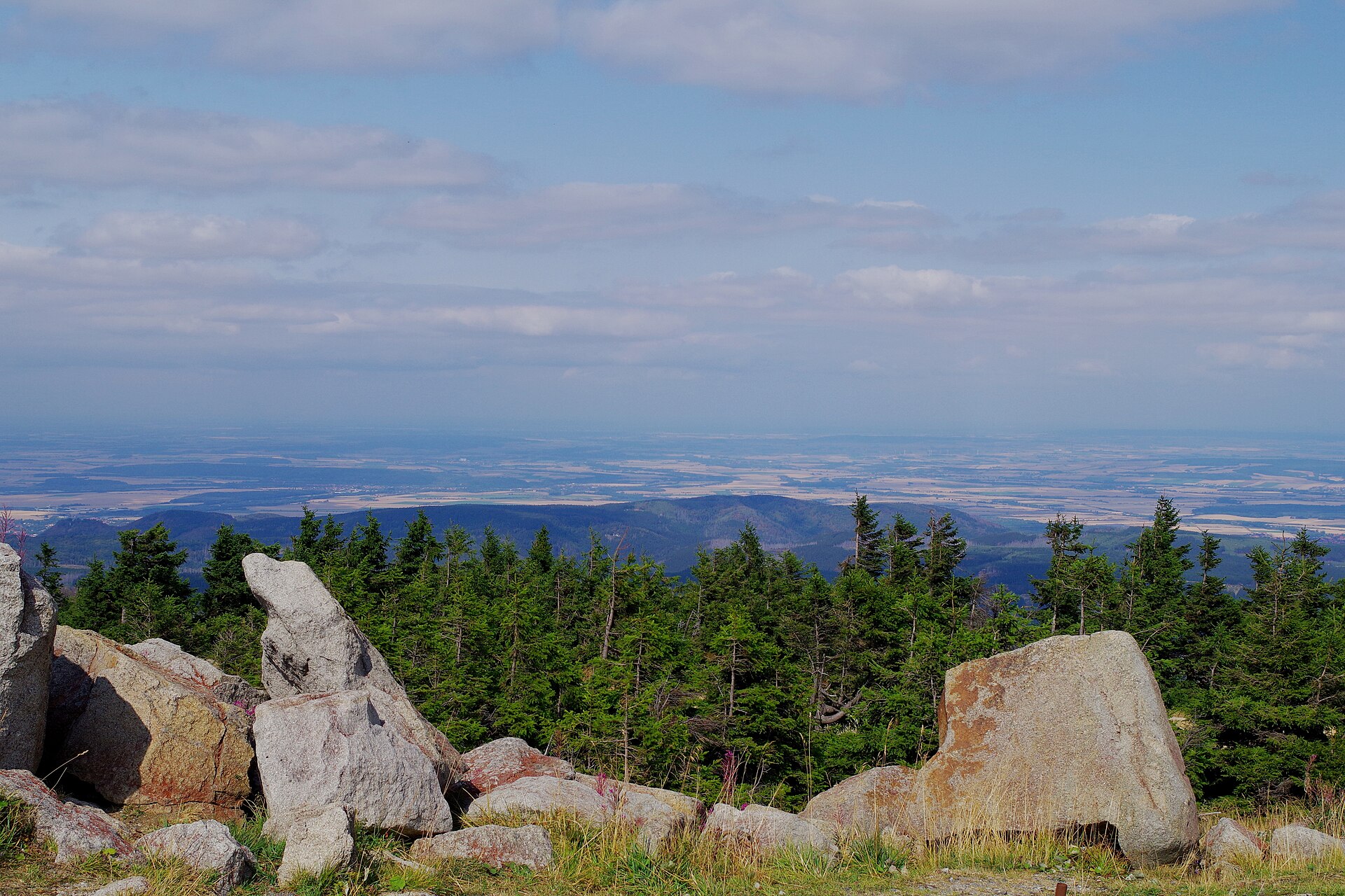
Felsenweg 6 starts at the Felsenweiher car park in Ernzen and makes a long circular route through the rock landscapes of the South Eifel. The route climbs around the Ferschweiler Plateau and passes geological features including the Teufelsschlucht, Stubenlay and Kuckuckslay. The official route is 17.4 km, with 440 m of ascent and descent.
Why it is essential
The Teufelsschlucht is one of the most recognisable rock landscapes in the Eifel. Felsenweg 6 is long enough to connect the gorge with the broader plateau and sandstone scenery, making it a stronger regional representative than a very short visit to the gorge alone.
Equipment
- Sturdy boots
- Weatherproof layer
- Warm layer
- Water and food
- Map or GPS
- Navigation backup
- Trekking poles useful on some sections
- Headtorch sensible for late starts or short-day seasons
Hazards and notes
- Wet rock
- Uneven steps
- Woodland mud
- Steep or narrow rock passages
- Avoid icy conditions
- Check local closure notices before departure
GPX / KML links
| Source | URL | Format | Notes |
|---|---|---|---|
| NaturWanderPark Delux official route download | imxplatform-cust-et.fsn1.your-objectstorage.com | GPX | Terms not clearly stated. Direct GPX found; reuse and attribution status unresolved. Replace with project-owned GPX later. |
| Official source page | naturwanderpark.eu | Source map / GPX | Terms not clearly stated. Authoritative source route for manual geometry recreation. |
Further reading
4. Eifelsteig Stage 4 — Einruhr to Gemünd
Snapshot
Itinerary
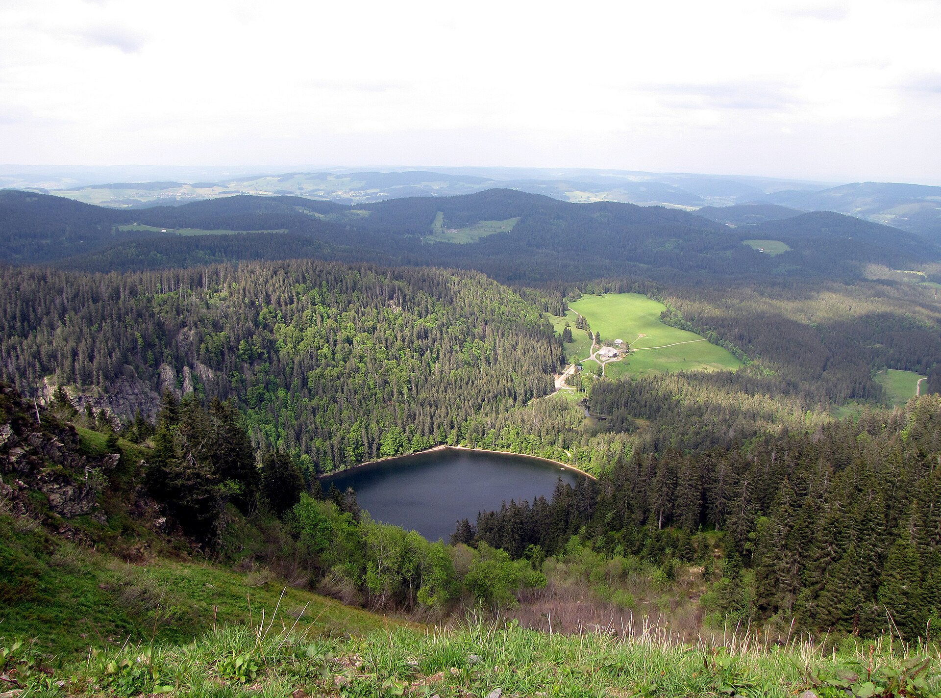
This stage of the Eifelsteig crosses a large part of the Eifel National Park landscape. From Einruhr, the route follows the Obersee and reaches the Urft dam area before crossing the Dreiborn plateau and passing Wollseifen and Vogelsang on the way to Gemünd. The official stage is 21.2 km, with 574 m ascent and 509 m descent.
Why it is essential
This is the strongest day-hike traverse in the selected Eifel set: reservoir shore, national park forest, open high plateau, the former village of Wollseifen, and the Vogelsang area are combined in one long stage. It represents the Eifel’s cultural and protected-area landscape better than a short circular walk.
Equipment
- Sturdy boots
- Weatherproof layer
- Extra warm layer
- Food
- Sufficient water for a long stage
- Map or GPS
- Navigation backup
- Headtorch for short-day seasons
- Trekking poles useful over the full distance
Hazards and notes
- Long distance
- Weather exposure on plateau sections
- Navigation at junctions
- Winter ice or snow
- Stay on marked paths in the national park
- Check current route, bus, boat and protected-area information before departure
GPX / KML links
| Source | URL | Format | Notes |
|---|---|---|---|
| Eifelsteig official route download | imxplatform-cust-et.fsn1.your-objectstorage.com | GPX | Terms not clearly stated. Direct GPX found; reuse and attribution status unresolved. Replace with project-owned GPX later. |
| Eifelsteig official stage page | eifelsteig.de | Source map / GPX | Terms not clearly stated. Authoritative source route for manual geometry recreation. |
Further reading
5. Traumschleife Baybachklamm
Snapshot
Itinerary
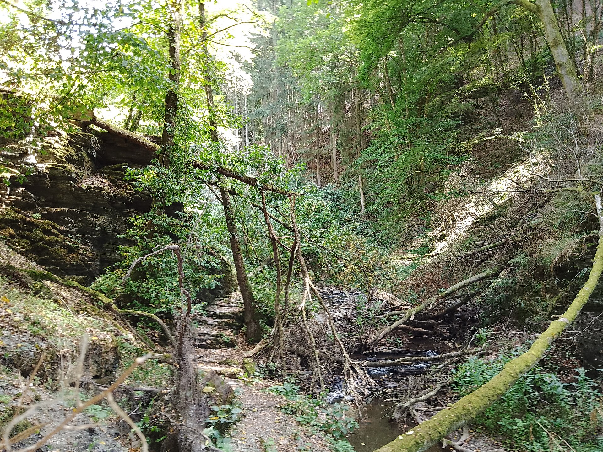
The Traumschleife Baybachklamm is a circular gorge hike in the Hunsrück. The route includes steep descents and ascents, rugged rock, deep slate-gorge scenery, and rope-aided difficult passages. The route passes through the Buchbach, Prinzbach and Baybach valleys, with features including old milling and charcoal-burning sites, the Schmausemühle area, and viewpoints such as the Barreterlay.
Why it is essential
Baybachklamm is one of the Hunsrück’s classic gorge hikes. It is more rugged than many low-mountain forest circuits, with slate cliffs, narrow valley paths, historical mill sites, and rope-secured passages. It adds a distinctly Hunsrück character to the regional selection.
Equipment
- Sturdy boots with strong grip
- Weatherproof layer
- Warm layer
- Water and food
- Map or GPS
- Navigation backup
- Trekking poles if comfortable on steep ground
- Gloves useful for rope-aided sections in wet or cold conditions
Hazards and notes
- Hard route grade
- Wet slate
- Steep descents
- Narrow paths
- Rope-secured passages
- Fallen leaves
- Ice
- High water
- Avoid in icy conditions and after severe weather unless local conditions are confirmed
GPX / KML links
| Source | URL | Format | Notes |
|---|---|---|---|
| Saar-Hunsrück-Steig official route page | saar-hunsrueck-steig.de | Source map / route page | Terms not clearly stated. Source route verified; direct GPX URL not captured. Replace with project-owned GPX later. |
| Rhineland-Palatinate Tourenplaner / tourism route | rlp-tourismus.com | GPS data via tour planner | Terms not clearly stated. GPS download availability indicated; direct file URL and reuse status unresolved. |
Further reading
- Saar-Hunsrück-Steig — Traumschleife Baybachklamm
- Rhineland-Palatinate Tourism — Baybach Gorge Dream Loop
- Deutsches Wanderinstitut — Traumschleife Baybachklamm
Further reading
| Source | URL |
|---|---|
| VisitWallonia — Ninglinspo | visitwallonia.com |
| VisitOVA — Ninglinspo | visitova.be |
| Cirkwi — Ninglinspo route | cirkwi.com |
| Mullerthal Trail — Auto-Pédestre Berdorf | mullerthal-trail.lu |
| Mullerthal Trail — Route 2 | mullerthal-trail.lu |
| NaturWanderPark Delux — Felsenweg 6 | naturwanderpark.eu |
| Eifelsteig — Stage 4 | eifelsteig.de |
| Saar-Hunsrück-Steig — Baybachklamm | saar-hunsrueck-steig.de |
| Rhineland-Palatinate Tourism — Baybachklamm | rlp-tourismus.com |
| Deutsches Wanderinstitut — Baybachklamm | wanderinstitut.de |