Regional overview
The Black Forest is a low-to-mid mountain region in south-west Germany, with a hiking character shaped by forested ridges, open summit meadows, glacial cirques, dark lakes, river gorges and panoramic high roads. The region includes vineyards, dense forests, river landscapes, gorges, valleys and exposed peaks across more than 300 towns and villages.
The main hiking centres include the Feldberg and Hochschwarzwald area, the Belchen and southern Black Forest, the northern Black Forest around Hornisgrinde and Mummelsee, the Wutach Gorge, and the Ortenau / Achertal area. The Black Forest Tourplanner is the official regional route-planning platform, and the Hochschwarzwald is recognised by the German Hiking Institute as a premium hiking destination.
The usual hiking season is spring to autumn, with the higher summits and gorge paths more sensitive to snow, ice, wind, storm damage and temporary closures. Many routes are accessible by rail or bus; in some tourism areas the KONUS guest card gives free local public-transport use, but route-specific timetables and seasonal buses still need checking before travel.
Selection rationale
These five hikes balance the main Black Forest hiking types: the highest summit and glacial lake at Feldberg, the panoramic Belchen massif, the northern high ridge and Mummelsee/Hornisgrinde moorland, the classic Wutach Gorge traverse, and the rocky Karlsruher Grat ridge with waterfalls. Each is recognised by official tourism bodies, premium-trail certification sources, or established route platforms.
Summary table
| # | Hike | Route type | Distance | Gain | Max elevation | Difficulty |
|---|---|---|---|---|---|---|
| 1 | Feldbergsteig | Loop | 12.44 km | 502 m | 1,487 m | Difficult |
| 2 | Belchensteig | Loop | 15.0 km | 675 m | 1,414 m | Difficult |
| 3 | Mummelsee–Hornisgrindepfad | Loop | 6.66 km | 272 m | 1,158–1,163 m | Moderate |
| 4 | Wutach Gorge — Wutachmühle to Schattenmühle | Point-to-point | 12.48 km | 230 m | 680 m | Moderate |
| 5 | Karlsruher Grat gourmet trail | Loop | 12.47 km | 660 m | 822 m | Difficult |
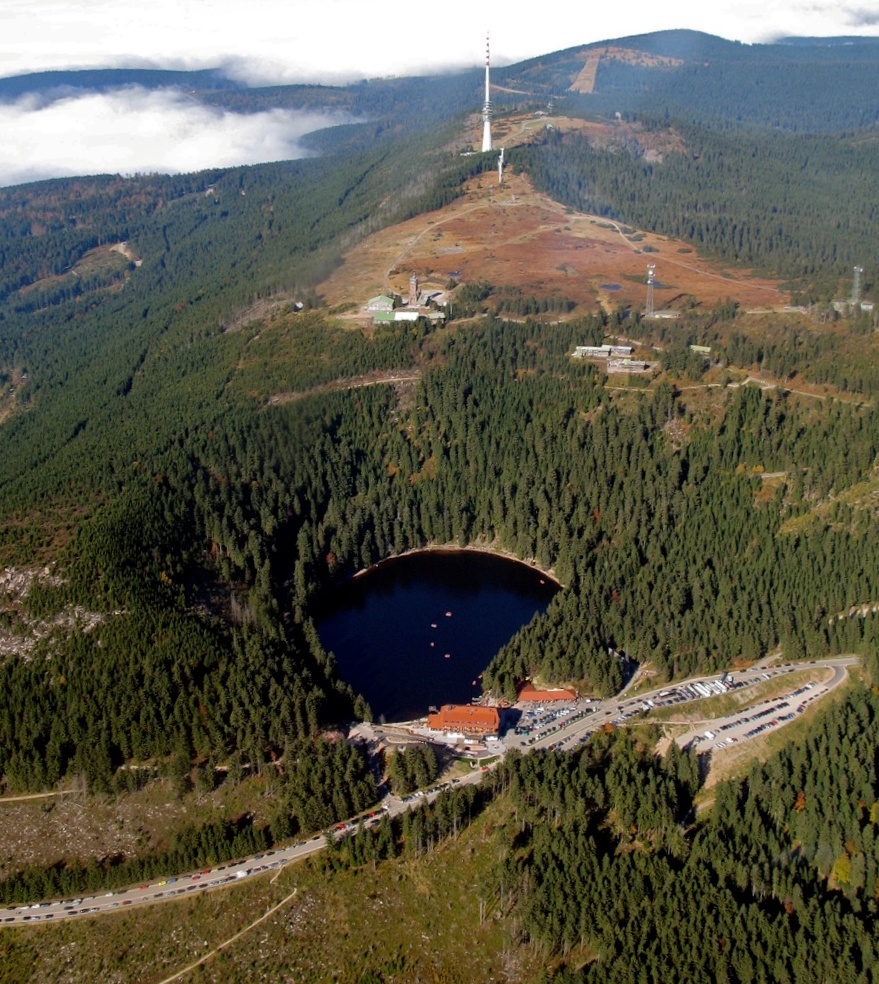
1. Feldbergsteig
Snapshot
Itinerary
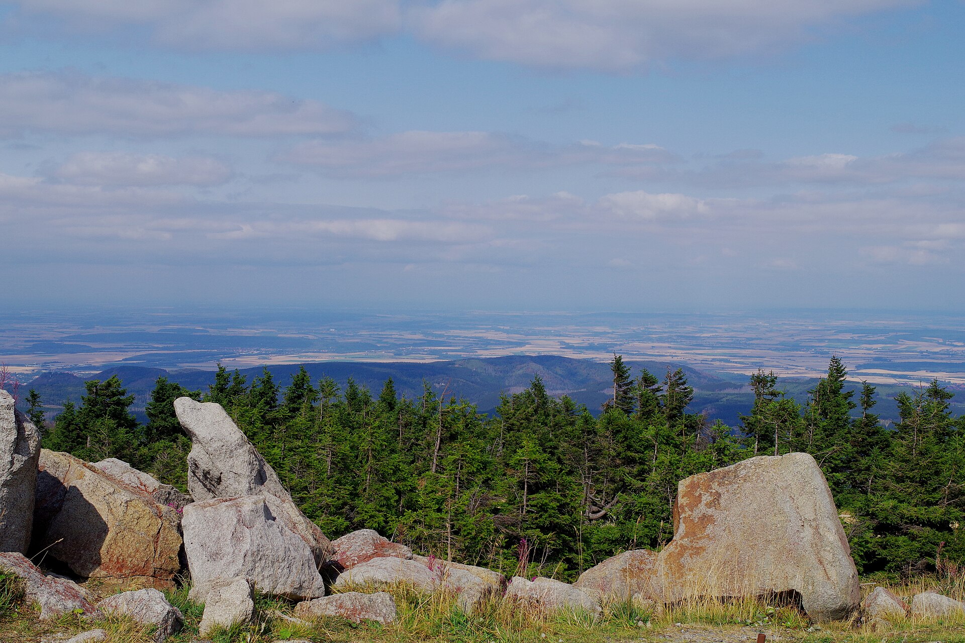
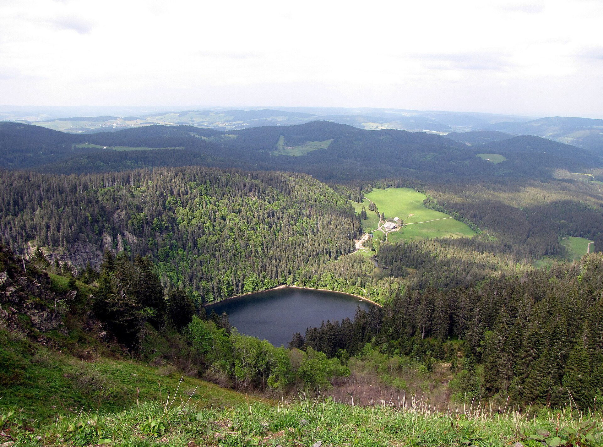
The route starts at the Haus der Natur and climbs through the Feldberg summit area, passing major viewpoints including the Bismarck monument and Feldberg tower. It then crosses the high summit landscape before descending past mountain huts and forest paths towards Raimartihof and Feldsee. The return follows the Karl-Egon-Weg back towards the Feldberg starting area. The official description notes views towards the Vosges and Swiss Alps in clear weather, and identifies Feldsee as a protected lake where bathing is prohibited.
Why it is essential
Feldberg is the highest massif of the Black Forest, and this route combines the region’s most prominent summit landscape with one of its best-known glacial lakes. It is the clearest representative route for the high Black Forest.
Equipment
- Sturdy boots
- Weatherproof layer
- Warm layer
- Food and water
- Map/GPS
- Navigation backup
- Trekking poles useful on the descent
- Tick protection sensible in forest sections
Hazards and notes
- Official route notes narrow paths and bridges.
- Not suitable for pushchairs.
- Dogs must be kept on a lead.
- Feldsee is protected; swimming is prohibited.
- Early or late season snow, ice and wind can make the high summit section more serious.
GPX / KML links
| Source | URL | Format | Notes |
|---|---|---|---|
| Official Feldberg-Erlebnis / Hochschwarzwald route page | feldberg-erlebnis.de | Route page with GPS download controls | Source route available; coordinate reuse to be replaced later |
| FKT route mirror | fastestknowntime.com | GPX listed | Secondary source only |
Sources
2. Belchensteig
Snapshot
Itinerary
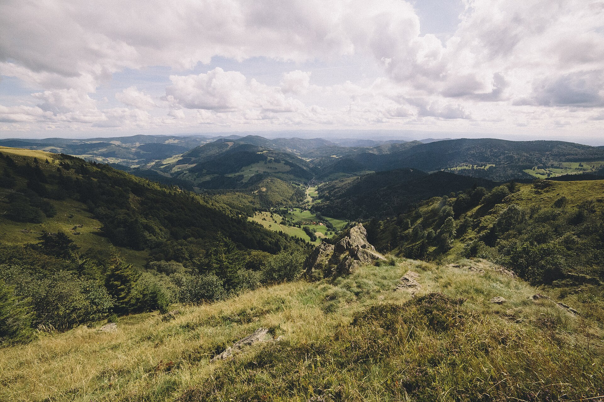
The route starts at Wiedener Eck and follows a broad loop through Lückle, Hintergrundbachtal and Untermulten towards Belchen-Multen and the Belchenbahn valley station. The official description notes that the cable car can shorten the route by about 2 km and 300 m of ascent. From the Belchenhaus area, the route continues to the Belchen summit before descending via Krinne and Heidstein back to Wiedener Eck.
Why it is essential
Belchen is one of the defining summits of the southern Black Forest. The route provides long-distance views across the Rhine plain, towards the Vosges and, in clear weather, the Alps, while also representing the open pasture and ridge character of the southern Black Forest.
Equipment
- Sturdy boots
- Waterproof layer
- Warm layer
- Water
- Food
- Map/GPS
- Navigation backup
- Trekking poles recommended
- Windproof layer important outside stable summer weather
Hazards and notes
- Belchen is often windy in spring and autumn.
- The Belchensteig is not a winter hiking route.
- If snow remains in spring or autumn, signed detours may be used and the summit can be skipped.
- Current passability is indicated at Wiedener Eck and the Belchen cable-car station.
GPX / KML links
| Source | URL | Format | Notes |
|---|---|---|---|
| German Hiking Institute | wanderinstitut.de | GPX | Route file found; coordinate reuse to be replaced later |
| Official Black Forest route page | blackforest-highlights.com | Route page with GPS download controls | Source route available; coordinate reuse to be replaced later |
Sources
- Schwarzwald Tourismus — Belchensteig
- German Hiking Institute — Belchensteig GPX
- Black Forest Highlights — Belchensteig
3. Mummelsee–Hornisgrindepfad
Snapshot
Itinerary
The route starts at Seibelseckle, passes under the Schwarzwaldhochstraße viaduct and reaches Mummelsee via forest paths. It then climbs over Katzenkopf towards Hornisgrinde, passing the Grinde-Hütte, Bismarck tower, high-moor boardwalk and Dreifürstenstein before returning on a narrower and steeper path to Seibelseckle. The route is officially described as a themed circular hike with views, the Grindenpfad, moorland boardwalk, Mummelsee, Hornisgrinde tower and several refreshment options.
Why it is essential
This is the compact northern Black Forest classic: a glacial lake, the highest summit of the northern Black Forest, exposed ridge-top moorland and the historic Schwarzwaldhochstraße landscape in one short day hike.
Equipment
- Hiking shoes or boots
- Weatherproof layer
- Warm layer
- Water
- Food
- Map/GPS
- Sun protection
- Warm clothing recommended because the Hornisgrinde ridge is exposed
Hazards and notes
- The route is short but exposed on the Hornisgrinde ridge.
- Wind, cold rain or low cloud can make conditions less benign than at Mummelsee.
- Official recommended season is May to October.
- In winter or icy shoulder-season conditions, boardwalks and steeper return paths can be slippery.
GPX / KML links
| Source | URL | Format | Notes |
|---|---|---|---|
| German Hiking Institute | wanderinstitut.de | GPX | Route file found; coordinate reuse to be replaced later |
| Official Schwarzwald Tourismus route page | schwarzwald-tourismus.info | Route page with GPS download controls | Source route available; coordinate reuse to be replaced later |
Sources
- Schwarzwald Tourismus — Mummelsee–Hornisgrindepfad
- Wanderbares Deutschland — Mummelsee–Hornisgrindepfad
- German Hiking Institute — Mummelsee–Hornisgrindepfad GPX
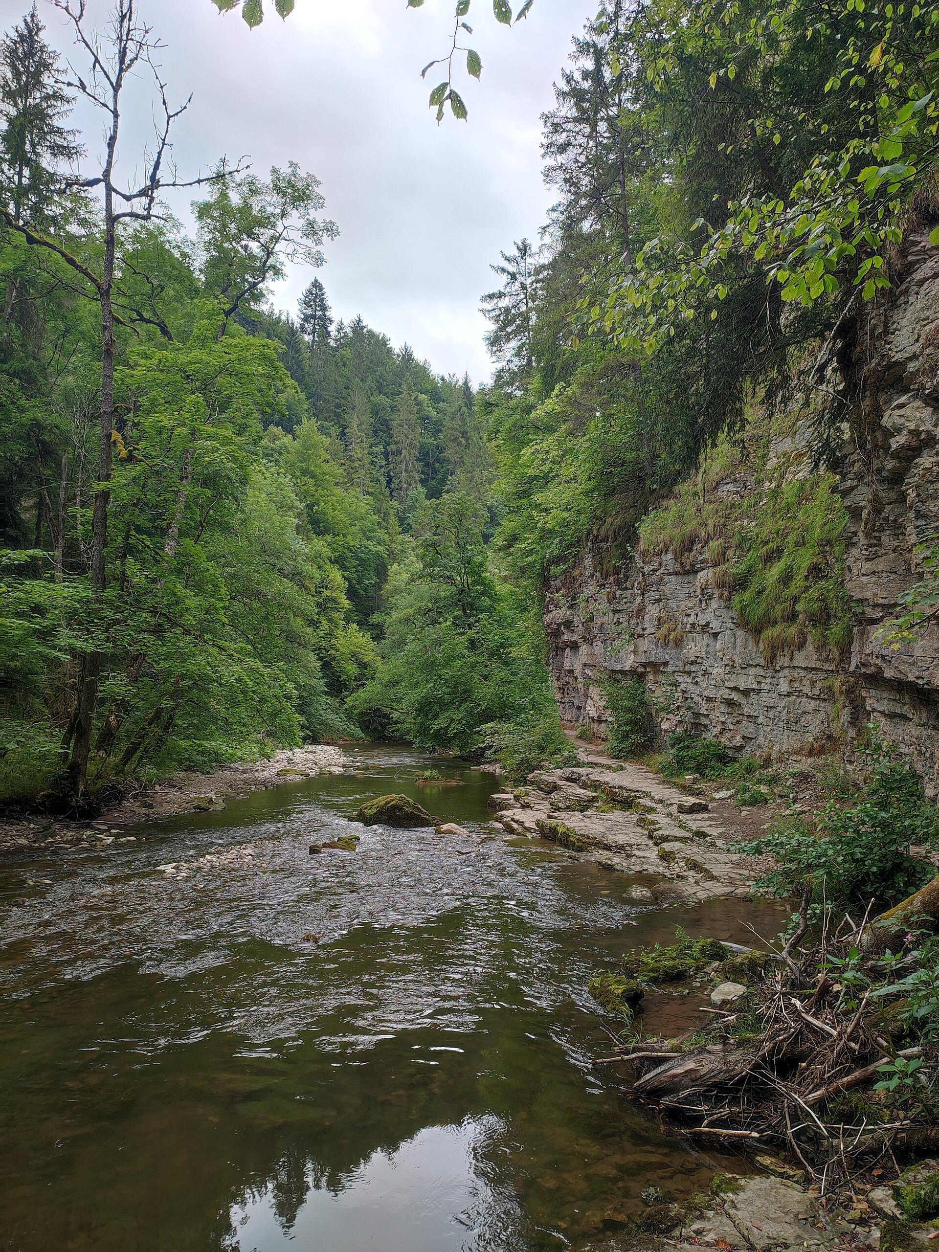
4. Wutach Gorge — Wutachmühle to Schattenmühle
Snapshot
Itinerary
The route follows the Wutach Gorge upstream from Wutachmühle to Schattenmühle on a section of the Schluchtensteig corridor. The official description notes steep forested and rocky gorge walls, narrow ledges, bridges including Kanadiersteg and Rümmelesteg, the Wutach outlet area, rock galleries near Bad Boll, waterfalls and the final section towards Schattenmühle. An optional exit at Boll can shorten the route by about 3 km.
Why it is essential
The Wutach Gorge is the Black Forest’s classic gorge walk: a deep, humid, geologically distinctive river landscape that contrasts strongly with the open summit hikes at Feldberg, Belchen and Hornisgrinde.
Equipment
- Sturdy boots with good grip
- Weatherproof layer
- Warm layer
- Water
- Food
- Map/GPS
- Navigation backup
- Trekking poles may help, but care is needed on narrow ledges
- Charged phone useful, though mobile reception is poor in parts of the gorge
Hazards and notes
- Surefootedness and a head for heights are essential.
- Paths can be wet and slippery.
- Mobile reception is poor in parts of the gorge.
- Current route information should be checked before departure.
- Dogs are allowed but should be kept on a lead because of steps and narrow paths.
- The route is not suitable for pushchairs.
- Seasonal hiking buses operate around the gorge from spring to early October, but timetables and ticket rules must be checked for the current season.
GPX / KML links
| Source | URL | Format | Notes |
|---|---|---|---|
| Hochschwarzwald German route page | hochschwarzwald.de | Route page with GPX/KML controls | Official source route available; coordinate reuse to be replaced later |
| Bergfex | bergfex.de | GPX/KML controls | Secondary route file source |
Sources
- Hochschwarzwald — Experience the Wutach Gorge
- Hochschwarzwald — Tour durch die Wutachschlucht
- Bergfex — Wutachschlucht
- Wutachschlucht — Wanderbus
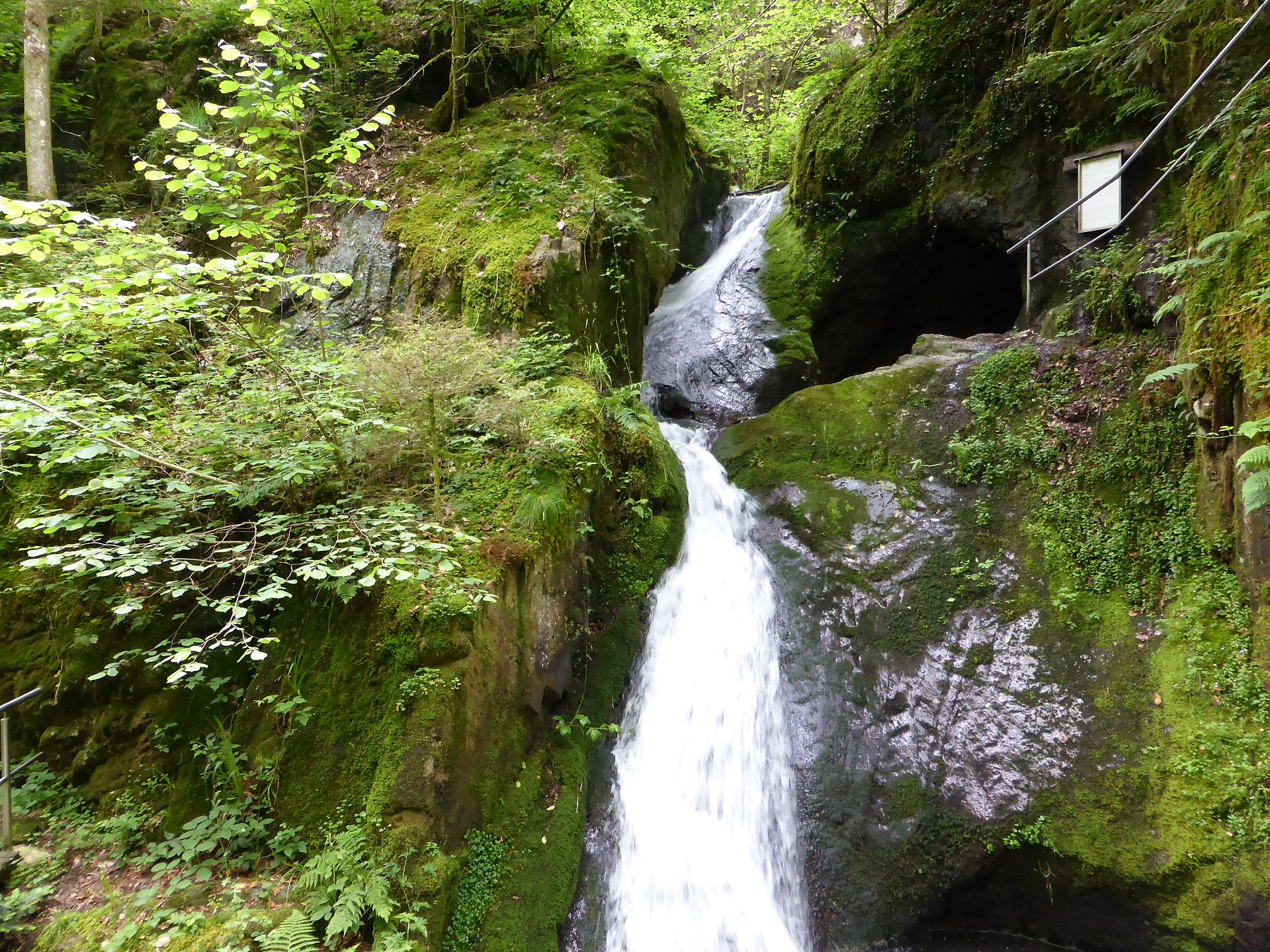
5. Karlsruher Grat gourmet trail
Snapshot
Itinerary
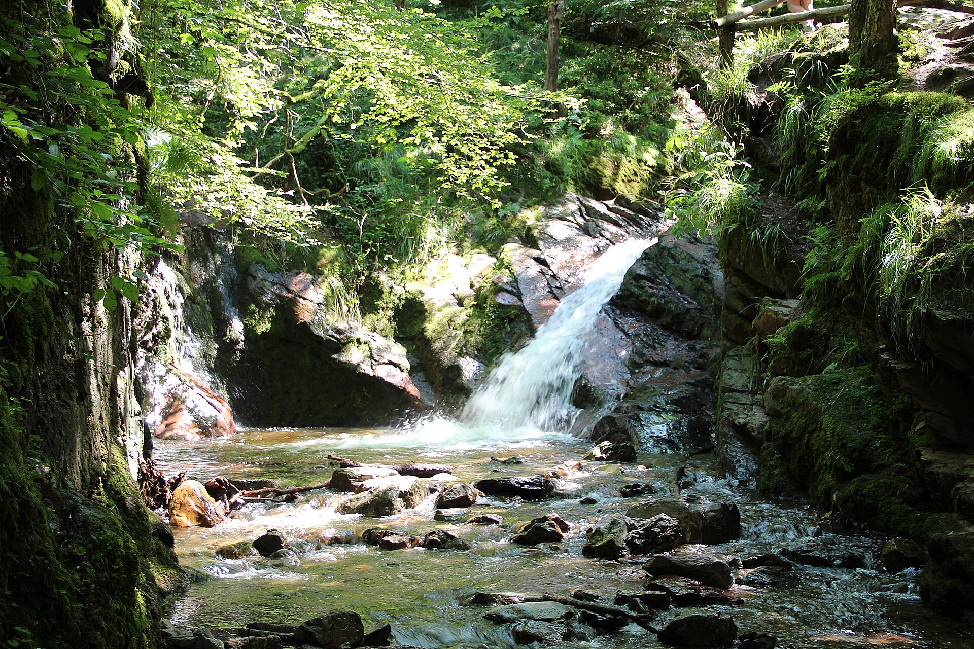
The route starts at Ottenhöfen, usually from the station or Kurpark area, and climbs towards the Gottschlägbach / Edelfrauengrab waterfalls. The path then continues through the nature reserve towards the rocky Karlsruher Grat ridge before returning via forest and village paths, including the Ottenhöfen station area. Official and certified-trail sources describe the route as combining waterfalls, rocky ridge terrain and Black Forest views.
Why it is essential
Karlsruher Grat adds a different Black Forest character from the summit and gorge routes: a narrow, rocky ridge with optional easy scrambling, close to waterfalls and forested ravines. It represents the more rugged sandstone and porphyry edge of the northern/central Black Forest hiking landscape.
Equipment
- Sturdy boots with good grip
- Weatherproof layer
- Warm layer
- Water
- Food
- Map/GPS
- Navigation backup
- Trekking poles useful on approach and descent but may be awkward on the ridge
- Avoid the exposed ridge in ice, heavy rain or strong wind
Hazards and notes
- The route is classified as difficult by official route sources.
- Experienced walkers can use a small climbing passage on the ridge.
- Surefootedness and fitness are required.
- The ridge should be treated cautiously in wet or icy conditions.
- Bypass options or conservative route choices should be considered where available.
GPX / KML links
| Source | URL | Format | Notes |
|---|---|---|---|
| German Hiking Institute | wanderinstitut.de | Route page with GPX download listed | Certified source route available; coordinate reuse to be replaced later |
| Visorando | visorando.com | GPX download control | Secondary route file source |
| Outdooractive / Black Forest Highlights | blackforest-highlights.com | Route page / source map | Source route available; coordinate reuse to be replaced later |
Sources
- Black Forest Highlights — Karlsruher Grat gourmet trail
- German Hiking Institute — Karlsruher Grat
- Visorando — Edelfrauengrab, Karlsruher Grat and waterfalls
Region-level sources
| Source | URL |
|---|---|
| Schwarzwald Tourismus / official Black Forest Tourplanner | touren-schwarzwald.info |
| Hochschwarzwald / Feldberg-Erlebnis | feldberg-erlebnis.de |
| Schwarzwald Tourismus — Belchensteig | schwarzwald-tourismus.info |
| Schwarzwald Tourismus — Mummelsee–Hornisgrindepfad | schwarzwald-tourismus.info |
| Wanderbares Deutschland — Mummelsee–Hornisgrindepfad | wanderbares-deutschland.de |
| German Hiking Institute | wanderinstitut.de |
| Wutach Gorge hiking bus | wutachschlucht.de |