Regional overview
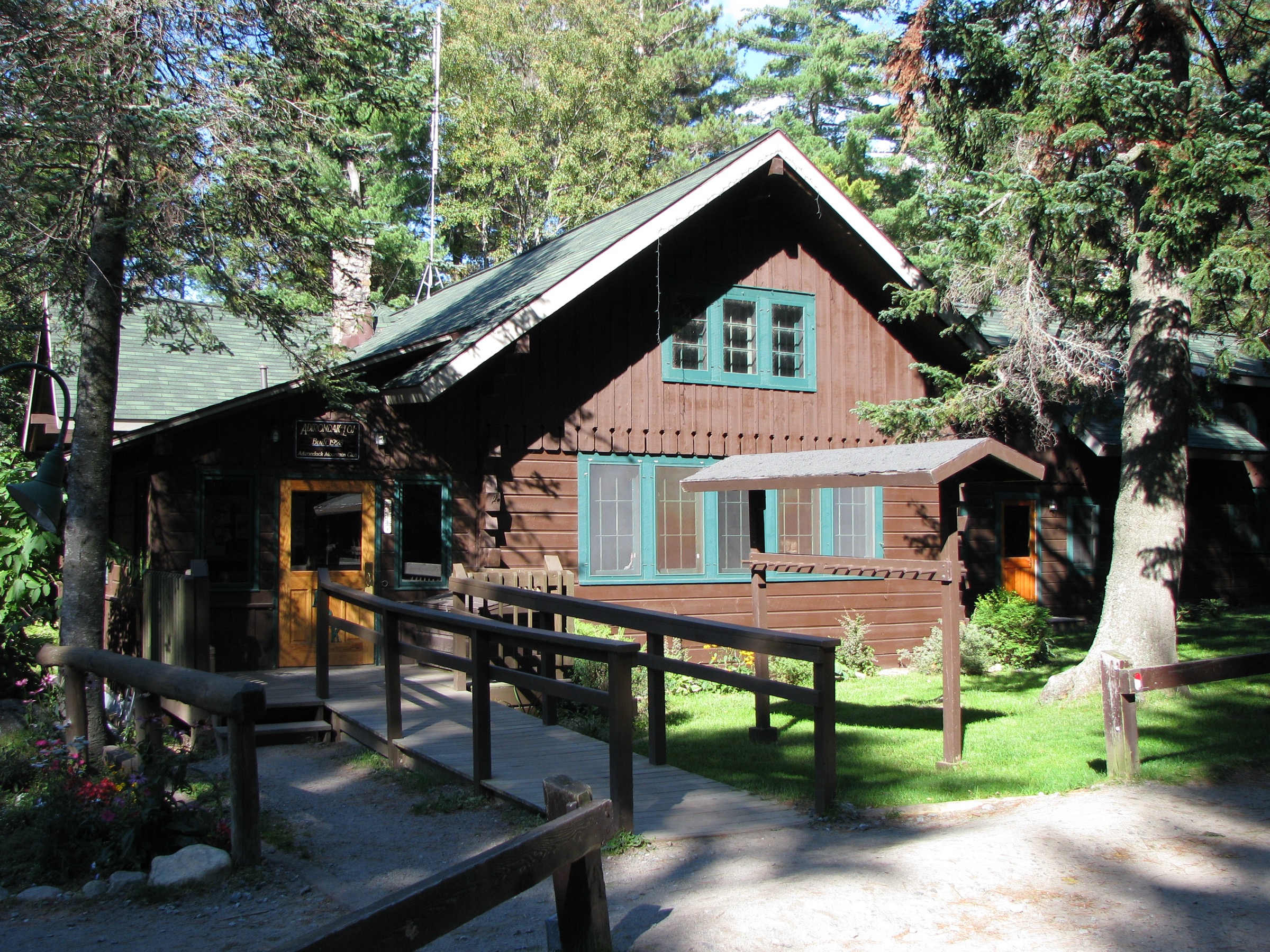
The Lake Placid and Keene Valley corridor is the working front of the Adirondack High Peaks — the villages, roads and access points from which most of the region’s peaks are climbed. Lake Placid, a Winter Olympic village of about 2,300 people at 570 m on the shore of Mirror Lake, is the northern gateway; Keene and Keene Valley on Route 73 form the eastern gateway; St. Huberts and the Adirondack Mountain Reserve sit at the entrance to the Great Range; and the Adirondak Loj at Heart Lake, at the end of Adirondak Loj Road, is the trailhead concentration point for the MacIntyre and Marcy summits. Route 73 between Lake Placid and Keene Valley is the region’s spine and passes almost every major High Peaks and Giant Mountain Wilderness trailhead.
The walks in this guide are the short-and-medium hikes of the corridor — the routes that a party takes when time, weather or fitness rules out a full 46er ascent, or when a rest-day objective is wanted between big mountain days. They cover the region’s four defining valley experiences: a short summit above the Adirondak Loj (Mount Jo), a village hill in Lake Placid itself (Cobble Hill), the classic cliff-top viewpoint of the “Adirondack fjord” (Indian Head over Lower Ausable Lake), an accessible bare-rock lookout above Keene (Owl Head Lookout), and one of the region’s finest waterfalls (Rainbow Falls at the head of Lower Ausable Lake).
Two of the five — Indian Head and Rainbow Falls — start at the Adirondack Mountain Reserve (AMR) at St. Huberts. The AMR is a private hunting-and-fishing club that grants public foot access to its trails under a long-standing conservation easement with New York State, subject to strict rules: no dogs, no camping, no swimming or fishing in AMR waters, and a mandatory hiker parking reservation from 1 May to 31 October each year, booked free on hikeamr.org. The 2026 reservation window opened on 17 April 2026; up to 70 daily reservations are issued, capped at 14 days in advance and up to 12 hours before arrival. The system applies to any arrival mode — car, drop-off, bike, or walk-in — which is one of the tightest access rules in the north-eastern United States. Mount Jo (Adirondak Loj), Cobble Hill (village) and Owl Head Lookout (private landowner easement in Keene) are outside the AMR system and require no reservation, but the Adirondak Loj charges a daily parking fee that has run at roughly US$25/day non-member and US$10 member (2024 posted rate; verify current 2026 rate on adk.org).
Terrain across the corridor is characteristically Adirondack: dense mixed hardwood and spruce–fir forest, rooty and rocky tread, waterfalls in every gorge, and abundant open rock — the anorthosite and metasedimentary “slabs” that give the region its walking character. Cell coverage exists in the villages and around Mirror Lake but drops away as soon as trails leave the roads. Weather is highly variable: summer highs into the high twenties Celsius, with afternoon thunderstorms common; autumn foliage typically peaks late September in the higher trees and mid-October in the valleys; snowmelt clears the low routes in April, but shaded slabs on Indian Head and Owl Head Lookout can hold ice into mid-May.
Public transport is limited but useful for two of these walks. A seasonal Trailhead Shuttle has run from Marcy Field (Keene) along Route 73 in past summers, serving trailheads including St. Huberts / AMR and the Roaring Brook / Giant Mountain area, and connecting to Keene Valley village — verify 2026 operating status with DEC or ADK closer to the season. Trailways coach service reaches Lake Placid year-round from Albany, Utica and New York City. There is no scheduled public transport to the Adirondak Loj or to the Owl Head Lookout trailhead on NY-9N.
Selection rationale
The five walks below are chosen as the essential short and medium hikes of the Lake Placid / Keene Valley corridor — the routes that a party without a 46er goal, or between big mountain days, would fold into a week in the region. Mount Jo is the short introductory summit at the Adirondak Loj and the classic first climb for a family or first-time Adirondack visitor. Cobble Hill is the local village walk, on foot from any hotel in Lake Placid. Indian Head with Fish Hawk Cliffs is the region’s most photographed viewpoint and the pre-eminent AMR walk. Owl Head Lookout gives a full High Peaks panorama for a fraction of the effort of a 46er, and sits outside the AMR system. Rainbow Falls delivers the region’s most spectacular waterfall — a ~45 m gorge cascade at the head of Lower Ausable Lake — on a route that is almost all gentle road-walking. Together they span every walking length, every access model, and every valley-level view type of the corridor.
Summary table
| # | Hike | Country | Route type | Distance | Gain | Max elevation | Difficulty |
|---|---|---|---|---|---|---|---|
| 1 | Mount Jo from Adirondak Loj | USA | Loop | ~4.0 km (~2.5 mi) | ~230 m | 876 m | Easy–moderate |
| 2 | Cobble Hill from Lake Placid village | USA | Out-and-back | ~2.6 km (~1.6 mi) | ~145 m | 714 m | Easy |
| 3 | Indian Head with Fish Hawk Cliffs (AMR) | USA | Loop | ~15.1 km (~9.4 mi) | ~510 m | 823 m | Moderate |
| 4 | Owl Head Lookout from NY-9N | USA | Out-and-back | ~8.0 km (~5.0 mi) | ~395 m | 771 m | Moderate |
| 5 | Rainbow Falls via AMR / West River Trail | USA | Out-and-back | ~13.7 km (~8.5 mi) | ~335 m | ~610 m | Moderate |
1. Mount Jo from the Adirondak Loj
Snapshot
Itinerary
From the Adirondak Loj High Peaks Information Center at Heart Lake, follow the signed Nature Trail west along the lakeshore to the Mount Jo trail junction at about 0.4 km. The route then splits: the Long Trail (rebuilt as a sustainable graded path opened by ADK in 2022) climbs at a gentler grade for about 1.6 km on switchbacks and stone steps, and is the preferred ascent for families and first-time visitors; the Short Trail climbs directly for about 0.7 km on a steep, rooty tread with a short rock scramble near the top and is the preferred descent for parties comfortable on steep ground. Both trails converge on the open summit ledge, a bare rock terrace with a full panorama south across Heart Lake to Algonquin Peak, Wright Peak and the MacIntyre Range, with Colden and Marcy behind. The Adirondak Loj campus is visible directly below. Return by the alternative trail to make a small loop.
Why it is essential
Mount Jo is named for Josephine Schofield, the fiancée of Henry Van Hoevenberg, who built the original Adirondack Lodge here in the 1880s. Its summit view is the same postcard image of the MacIntyre Range that appears in almost every historical photograph of the ADK Loj. As the shortest and lowest summit in the region with a full High Peaks panorama, it is the archetypal introductory Adirondack climb: about two hours of walking for one of the most complete views of the range.
Equipment
- Standard hiking shoes with grip
- Weatherproof shell
- 1.5 L water
- Sun protection for the summit ledge
- Trekking poles optional; helpful on the Short Trail descent
- Map (available at the ADK Loj High Peaks Information Center)
- Microspikes November to April on the shaded upper ledges
Hazards and notes
- The Short Trail is steep and gets slippery when wet or icy — descending it in the wet is the most common cause of Mount Jo incidents
- Fragile summit vegetation on the open ledge — stay on rock
- Adirondak Loj parking fills by mid-morning on peak weekends; ADK daily fee applies (2024 posted rate ~US$25/day non-member; verify 2026 rate)
- Trail register at the trailhead — sign in and out
- Cell coverage is patchy at the Loj
GPX / KML links
| Source | URL | Format | Notes |
|---|---|---|---|
| Adirondack Mountain Club — Mount Jo | adk.org | Official page | Trail description and access notes |
| Lake Placid Regional Office — Mt Jo | lakeplacid.com | Official tourism page | Route summary and current status |
| Waymarked Trails — Mount Jo | hiking.waymarkedtrails.org | OSM route relations | Both Long and Short trails mapped in OSM |
Sources
- Adirondack Mountain Club — Mount Jo
- Adirondack Mountain Club — Sustainable Long Trail opens
- Lake Placid Regional Office — Mt Jo
2. Cobble Hill from Lake Placid village
Snapshot
Itinerary
The trailhead is on the Northwood School side of Mirror Lake Drive, where a wooden boardwalk installed in the 2023 rebuild leads off the road into hardwood forest. The route then splits: a steep option climbs directly for about 0.6 km with a short, sharp final pitch, and a longer graded option at about 1.8 km one-way winds up through more forest at an easier grade. Both meet near the summit at a partial rock ledge with filtered views north-west across Mirror Lake to Whiteface Mountain and along the ridge line back toward the MacIntyre Range. There are no dedicated hiker parking bays — walking from a Mirror Lake hotel, a downtown car park or the Northwood School area is the standard approach. The trail is on land protected by the Adirondack Land Trust; a full rebuild in 2023 added drainage, boardwalk sections and stabilised tread.
Why it is essential
Cobble Hill is the only genuine summit walk that can be started from the streets of Lake Placid. Its lookouts frame Whiteface across Mirror Lake — the classic in-town Adirondack composition — and it fills the role of a first-morning acclimatisation walk or an evening leg-stretcher between big mountain days without the drive to a wilderness trailhead. It also demonstrates the Adirondack Land Trust’s trail-stewardship model in a form that is directly walkable from any hotel in the village.
Equipment
- Standard walking shoes or trainers
- Weatherproof shell
- 1 L water
- Microspikes November to March — the shaded lower half retains ice through spring
- Headtorch if starting or finishing near dusk
Hazards and notes
- Road-crossing hazard: the trailhead is on a fast section of Mirror Lake Drive; cross with care
- No dedicated parking; do not block the Northwood School driveway
- Trail can be muddy in spring; stay on the boardwalk where installed
- Some short exposure at the summit ledge — keep small children close
- Cell coverage generally good throughout
GPX / KML links
| Source | URL | Format | Notes |
|---|---|---|---|
| Lake Placid Regional Office — Cobble Hill | lakeplacid.com | Official tourism page | Route summary, images |
| Pure Adirondacks — Cobble Hill | pureadirondacks.com | Route description | Distance and elevation notes |
| Adirondack Land Trust — Cobble Hill Trail Project | adirondacklandtrust.org | Landowner page | Conservation and rebuild history |
Sources
3. Indian Head with Fish Hawk Cliffs (AMR)
Snapshot
Itinerary
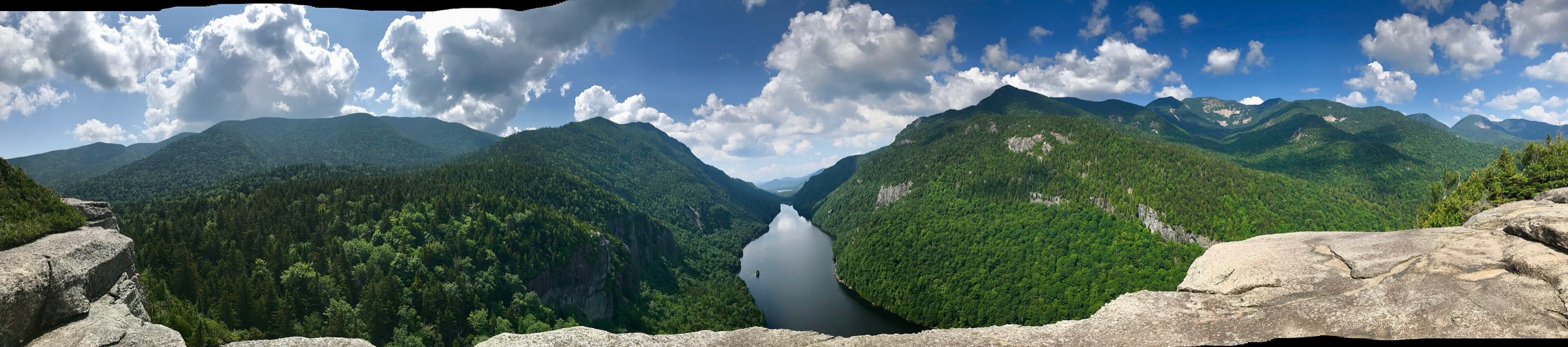
From the AMR St. Huberts hiker parking lot on Ausable Road, walk south past the Ausable Club to the register at the Lake Road gate. The Lake Road — a private, gently graded gravel road maintained by AMR — runs about 5.5 km to the north end of Lower Ausable Lake, past the golf course and through mature hardwoods. At about 1.5 km from the gate, take the signed Gill Brook Trail left off the road; the trail climbs steadily beside the brook past a sequence of cascades, then joins the Indian Head trail at a signed junction. From there a short climb — including one wooden ladder near the top — reaches the Indian Head overlook, a cliff-top rock terrace directly above the head of Lower Ausable Lake with the finest single view in the Adirondack Mountain Reserve: the long fjord-like lake below, the vertical wall of the Great Range on the west, and the Colvin–Sawteeth ridge on the east. Continue south along the ridge to the Fish Hawk Cliffs spur (a short detour with a second cliff-top viewpoint), then descend the Fish Hawk / Gothics Window trail back to the Lake Road and return north to the AMR gate. Dogs are prohibited on AMR trails.
Why it is essential
Indian Head is the pre-eminent viewpoint of the Adirondack Mountain Reserve and — since the AMR permit system began — the region’s most tightly managed walk. The view from the summit rocks over Lower Ausable Lake, framed by the Great Range and the Colvin ridge, is the archetypal image of the “Adirondack fjord” and appears on more Adirondack tourism material than any other summit view except Marcy. The route is long but almost entirely well-graded, and it offers the region’s most complete accessible-yet-committing valley walk without any of the alpine-summit hazards of the 46ers.
Equipment
- Sturdy hiking shoes or boots
- Weatherproof shell
- Warm layer for the cliff-top rest
- 2.5–3 L water; treat any stream water
- Sun protection for the cliff-top lookouts
- Trekking poles helpful for the descent
- Map, compass and downloaded DEC / AMR map
- Headtorch for a late finish
- Microspikes into late May for shaded ledges
Hazards and notes
- AMR parking reservation is mandatory 1 May to 31 October — free, up to 14 days in advance at hikeamr.org; without it, no access
- No dogs on AMR trails — this is a strict rule and enforced
- No swimming, no fishing in AMR waters; stay off private property clearly marked around the golf course
- Cliff-top exposure at both Indian Head and Fish Hawk Cliffs — keep back from the edge, especially in wind
- One wooden ladder at the top of the climb; can be slippery when wet
- Long day: plan the round-trip time carefully and start early
- Cell coverage absent above the AMR gate
GPX / KML links
| Source | URL | Format | Notes |
|---|---|---|---|
| Adirondack Mountain Reserve — hiker permit | hikeamr.org | Official permit page | Reservation portal; mandatory 1 May – 31 October |
| Lake Placid Regional Office — Indian Head and Fish Hawk Cliffs | lakeplacid.com | Official tourism page | Route summary, images |
| ADK — Visiting the Adirondack Mountain Reserve | adk.org | Official page | Access rules and AMR context |
Sources
- Adirondack Mountain Reserve — hikeamr.org
- Lake Placid Regional Office — Indian Head and Fish Hawk Cliffs
- ADK — Visiting the Adirondack Mountain Reserve
4. Owl Head Lookout from NY-9N
Snapshot
Itinerary
Owl Head Lookout is a small bare-rock summit at the north-eastern edge of the Giant Mountain Wilderness. The trail is signed off NY-9N — not NY-73 — with a small DEC lot on private land at the end of Owl’s Head Lane. From the register, the trail follows a former dirt driveway east through mixed hardwoods and crosses Slide Brook on a small footbridge at about 0.8 km. Beyond the brook the route climbs steadily below a line of low cliff bands, then breaks left onto a steeper 0.8 km push through spruce and open rock. A signed 0.1 km spur leads to the lookout: a bare rock terrace with a wide view west across Keene Valley to Giant, Rocky Peak Ridge, and Hurricane Mountain to the north, and — on clear days — the full skyline of the eastern High Peaks. Return by the same route. Note: this Owl Head is a different peak from the fire-tower Owls Head Mountain in Long Lake (Hamilton County), which shares the name but is 100 km away.
Why it is essential
Owl Head Lookout delivers one of the fullest High Peaks panoramas in the corridor for a fraction of the effort of a 46er — Giant and Rocky Peak Ridge fill the western skyline directly across the valley, and the Great Range unfolds behind. It also sits entirely on DEC Forest Preserve land within the Giant Mountain Wilderness and outside the AMR system, meaning no reservation is required and the trailhead is open year-round to any hiker with appropriate winter kit. That combination — a big-view summit at moderate effort, on public land, on a non-AMR access road — makes it the obvious answer to the question of “what to walk if I want a High Peaks view but no long day or paperwork.”
Equipment
- Sturdy hiking shoes or boots
- Weatherproof shell
- Warm layer for the exposed lookout
- 2 L water
- Sun and wind protection for the summit rock
- Trekking poles helpful on the steeper upper pitch
- Map, compass and downloaded DEC map
- Microspikes into late May and again from October for the summit slabs
Hazards and notes
- Slick summit rock when wet or icy — descend with care
- Small trailhead parking area on a private easement; do not block the road
- Bear canisters required for overnight users in the Eastern High Peaks Wilderness 1 April to 30 November — day walkers exempt but must not leave food unattended
- Trail register at the trailhead — sign in and out
- Cell coverage patchy on the lookout, absent on the trail
- Hunting season (October–December) — wear high-visibility colours on the lower approach
GPX / KML links
| Source | URL | Format | Notes |
|---|---|---|---|
| NY State DEC — Giant Mountain Wilderness | dec.ny.gov | Official page | Regional wilderness map |
| Lake Placid Regional Office — Owl Head Lookout | lakeplacid.com | Official tourism page | Route summary, current status |
| Adirondack Explorer — Owl Head Lookout | adirondackexplorer.org | Independent adventure planner | Route description and images |
Sources
- NY State DEC — Giant Mountain Wilderness
- Lake Placid Regional Office — Owl Head Lookout
- Adirondack Explorer — Owl Head Lookout
5. Rainbow Falls via the AMR / West River Trail
Snapshot
Itinerary
From the AMR St. Huberts hiker parking lot, walk south past the Ausable Club to the register at the Lake Road gate. Follow the graded gravel Lake Road south for about 5.5 km to the north end of Lower Ausable Lake, where a bridge crosses the Ausable River outflow at the dam. On the far side of the bridge a signed side-trail leads west up a short, steep-walled gorge on a slippery spur alongside Rainbow Brook. Rainbow Falls is a ~45 m (~150 ft) horsetail cascade tucked into a shaded gorge — one of the tallest waterfalls in the eastern High Peaks and, at spring peak flow after snowmelt, one of the loudest. The spur is narrow, wet, and often icy in shoulder seasons; care is needed on the return descent. Retrace the Lake Road back to the AMR gate. Combined with the Indian Head route, Rainbow Falls makes a natural full-day objective — the two viewpoints share the Lake Road walk and the same AMR permit.
Why it is essential
Rainbow Falls is the region’s most spectacular waterfall on a route that is almost entirely gentle road-walking. It is the natural companion objective to Indian Head, using the same AMR permit and the same Lake Road approach, and — for a party that wants a big-name Adirondack waterfall without a serious summit day — it is the pre-eminent AMR walking objective. The falls sit at the head of Lower Ausable Lake, framed by the steep west wall of the Great Range and reachable only through the AMR system, which gives them their unusual sense of enclosure.
Equipment
- Sturdy walking shoes or boots — the gorge spur is slippery
- Weatherproof shell
- Warm layer for the shaded gorge
- 2 L water
- Sun protection for the road walk
- Trekking poles helpful on the gorge descent
- Map and downloaded AMR / DEC map
- Microspikes into early June for the shaded gorge ice
Hazards and notes
- AMR parking reservation is mandatory 1 May to 31 October — free at hikeamr.org
- No dogs on AMR trails
- The short gorge spur to the base of the falls is narrow, wet and steep; treat as a scramble in the wet
- Do not attempt to climb behind or above the falls — the wet rock is dangerous even in low flow
- Long day; the Lake Road walk is straightforward but adds up to ~11 km round-trip before the falls spur
- Cell coverage absent above the AMR gate
- Combining with Indian Head adds ~2 km and ~370 m of climb to a full-day version
GPX / KML links
| Source | URL | Format | Notes |
|---|---|---|---|
| Adirondack Mountain Reserve — hiker permit | hikeamr.org | Official permit page | Reservation portal |
| Lake Placid Regional Office — Rainbow Falls | lakeplacid.com | Official tourism page | Route summary, images |
| ADK — Visiting the Adirondack Mountain Reserve | adk.org | Official page | AMR rules and access |
Sources
- Adirondack Mountain Reserve — hikeamr.org
- Lake Placid Regional Office — Rainbow Falls
- ADK — Visiting the Adirondack Mountain Reserve
Missing data / follow-up work
- cobble-hill.jpg, cover-high-peaks.jpg, owl-head-lookout.jpg, rainbow-falls.jpg — the pre-downloaded assets could not be matched with confidence to Wikimedia Commons source files at the required ≥2400 px resolution and matching aspect ratio; no figures have been embedded for those sections. If licence-verified images can be sourced (or the current files can be traced to specific Commons titles) figures should be added.
- Trailhead Shuttle 2026 operating status — the seasonal Route 73 shuttle from Marcy Field has historically served St. Huberts, Roaring Brook and other Route 73 stops. 2026 operating status is not yet confirmed and should be verified with DEC or Lake Placid CVB.
- Adirondak Loj parking fee 2026 — the 2024 posted rate was ~US$25/day non-member and US$10 member; the 2026 rate should be re-checked on adk.org before travel.
- AMR Hiker Permit season 2026 — the reservation system returned on 17 April 2026 and runs 1 May to 31 October, up to 70 daily reservations, capped at 14 days ahead and up to 12 hours before arrival. Any changes for later in the season should be checked on hikeamr.org.
- Cobble Hill parking — the trailhead has no dedicated hiker lot; if the Lake Placid CVB or Adirondack Land Trust opens formal parking in the 2026 season, this article should be updated.
Further reading
| Source | URL |
|---|---|
| NY State DEC — High Peaks Wilderness Complex | dec.ny.gov |
| NY State DEC — Giant Mountain Wilderness | dec.ny.gov |
| NY State DEC — Adirondack Backcountry | dec.ny.gov |
| Adirondack Mountain Club (ADK) | adk.org |
| ADK — Visiting the Adirondack Mountain Reserve | adk.org |
| ADK — High Peaks Information Center | adk.org |
| Adirondack Trail Improvement Society (ATIS) | atis.org |
| AMR Hiker Permit — hikeamr.org | hikeamr.org |
| Adirondack Explorer | adirondackexplorer.org |
| Lake Placid Regional Office of Sustainable Tourism | lakeplacid.com |
| Adirondack Land Trust | adirondacklandtrust.org |
| Hike ADK — trail status | hikeadk.com |