Regional overview
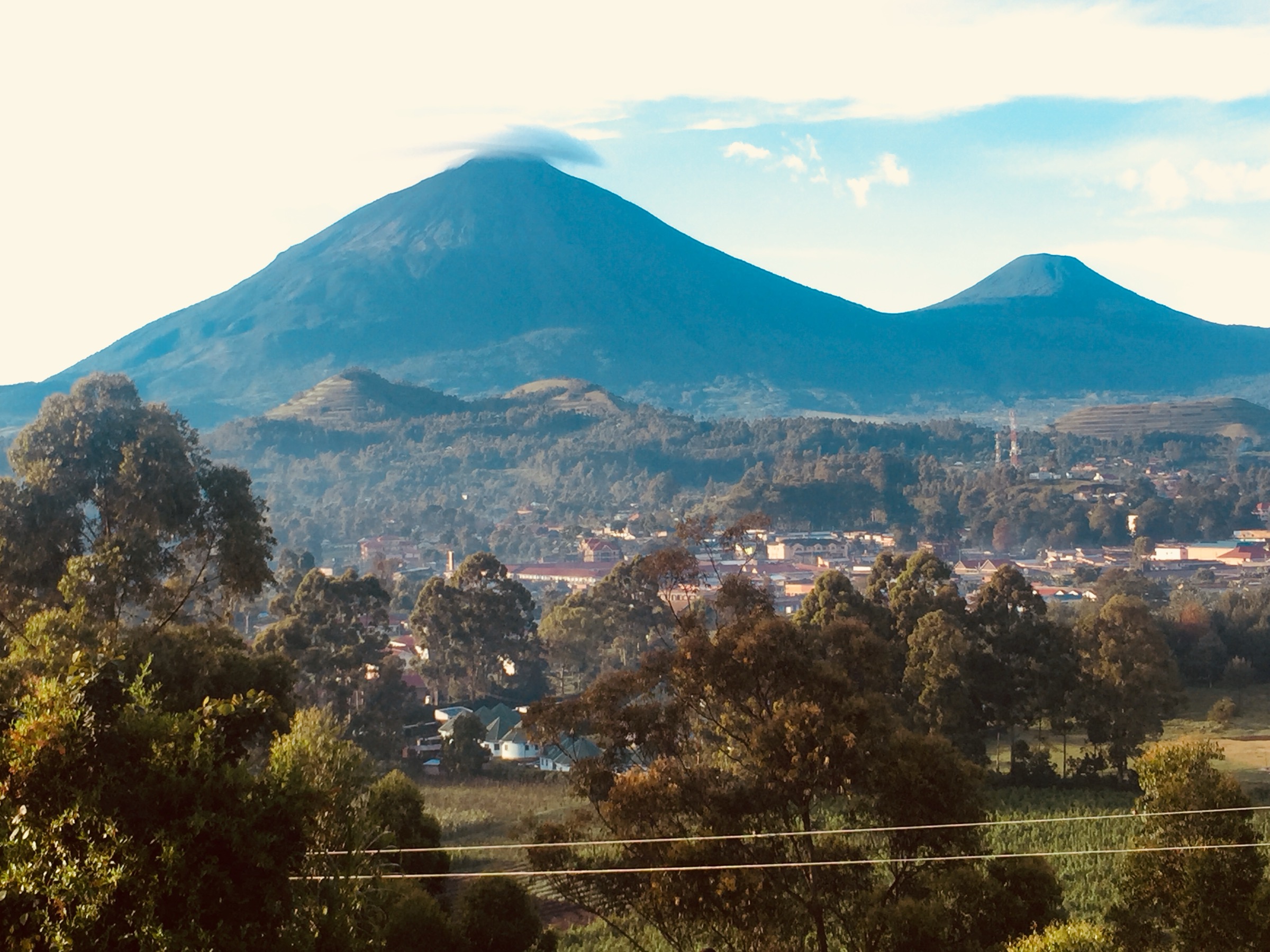
The Rwenzori Mountains rise on the equator between Lake Albert and Lake Edward, straddling the border between Uganda and the Democratic Republic of the Congo. The range is roughly 120 km long and 65 km wide, with six glacier-bearing massifs at its core; Margherita Peak on Mount Stanley reaches 5,109 m and is the third-highest summit in Africa. The Ugandan side is protected by Rwenzori Mountains National Park, gazetted in 1991, inscribed as a UNESCO World Heritage Site in 1994, and listed as a Ramsar Wetland of International Importance in 2008. The Congolese side falls within Virunga National Park.
The walking character of the Rwenzori is overwhelmingly that of a long-trek range. Almost every recognised route — the Central Circuit from Nyakalengija and the Kilembe Trail from Kyanjuki on the Ugandan side, the Bukurungu Trail in the northern spur, the Kazingo Trail to Bundibugyo, and the historic Italian / Stanley approach from the Congolese side — is structured as a 3-10 day expedition with hut or camp stages, ranger escort, and porter logistics organised by Uganda Wildlife Authority concessionaires. Essential one-day hikes therefore tend to be either the first-day section of a longer trek, a single in-and-out objective at the forest-alpine boundary, or community and foothill walks just outside the park. The four core walking centres for day hikers are Nyakalengija (Central Circuit gate), Kyanjuki / Kilembe (Kilembe Trail gate), Ruboni village (community walks), and the Kasese-Bundibugyo road corridor for the Sebwe and Bugoye foothills.
Terrain rises rapidly from cultivated foothills at 1,500-1,700 m through Afro-montane rainforest with podocarpus and bamboo, into heather and giant-lobelia zones above about 3,000 m, and into glaciated alpine terrain above 4,000 m. Rainfall is heavy and bimodal: the heaviest wet periods are March-May and September-November, with annual precipitation in the upper foothills around 2,500 mm; the recognised drier windows for hiking are December-February and June-September. Mud, leeches, slippery roots, river crossings and rapidly closing cloud are persistent issues even on short routes.
Several access and safety constraints are central to planning. All Ugandan day hikes inside the national park require a Uganda Wildlife Authority entry fee and, on park-side trails, a UWA armed ranger escort arranged through one of the licensed operators — Rwenzori Mountaineering Services for the Central Circuit and Rwenzori Trekking Services for the Kilembe Trail. As of mid-2026 the Congolese approach to Mount Stanley via Mutwanga is closed: Virunga National Park has been closed to tourism since 2024-2025 as a result of the M23 conflict and associated occupation of large parts of eastern DRC, and DRC-side itineraries to the Rwenzori are not currently viable. On the Uganda side, the UK Foreign, Commonwealth and Development Office advises against all but essential travel to the strip immediately south-west of Kasese town up to the DRC border at Kyabikere as a result of cross-border security incidents recorded as recently as November 2025. As of mid-2026 Uganda is also subject to a US Department of State Level 4 advisory tied to an outbreak of the Bundibugyo strain of Ebola virus disease declared on 15 May 2026; this advisory is health-driven and must be reviewed against current guidance before any travel planning.
Selection rationale
The Rwenzori range is overwhelmingly a multi-day trekking destination, so this catalogue treats one-day sections of longer treks as legitimate day-hike entries. The five routes below cover the iconic lake-and-forest objective inside the national park (Lake Mahoma), the canonical Central Circuit Day 1 as a stand-alone out-and-back (Nyabitaba Hut), the equivalent first-day section of the southern Kilembe Trail (Sine Camp forest exploration), a foothill waterfall hike that does not require a UWA hut stage and is more accessible to short-visit walkers (Sebwe Falls from Kisamba), and the leading community-and-viewpoint walk at the park gateway (Ruboni). Together they cover the forest, foothill, lake-shore and cultural character of the Ugandan Rwenzori. The DRC side is deliberately not represented because Virunga National Park is closed and access is unsafe at the time of writing.
Summary table
| # | Hike | Country | Route type | Distance | Gain | Max elevation | Difficulty |
|---|---|---|---|---|---|---|---|
| 1 | Lake Mahoma day hike from Nyakalengija | Uganda | Out-and-back | 17 km | 1,350 m | 3,000 m | Hard |
| 2 | Nyabitaba Hut day section (Central Circuit Day 1) | Uganda | Out-and-back | 14-20 km | 1,000-1,200 m | 2,651 m | Hard |
| 3 | Kilembe Trail forest exploration to Sine Camp | Uganda | Out-and-back | 10-12 km | 1,150 m | 2,596 m | Hard |
| 4 | Sebwe Falls from Kisamba (Bugoye) | Uganda | Out-and-back | — | — | — | Moderate-Hard |
| 5 | Ruboni community hill walk and village trail | Uganda | Loop / out-and-back | — | — | 2,300 m | Moderate |
1. Lake Mahoma day hike from Nyakalengija
Snapshot
Itinerary
The route begins at Mihunga gate near Nyakalengija, where the Central Circuit officially starts. After UWA registration the trail climbs through cultivated foothills and village land, enters the Afro-montane forest belt above the park boundary, and crosses tributaries of the Mubuku river system. The footpath follows the main Central Circuit Day 1 line for the first 6-7 km of climbing, passing dense podocarpus and bamboo, before branching to the spur path that climbs to Lake Mahoma — a small, deep glacial lake set at roughly 3,000 m in moss-draped forest. After time at the lake the same route is descended to Nyakalengija. Some operators run the hike as a long day with an early start and a porter; others split the same itinerary as an overnight stage at Nyabitaba or Omuka Kizza camp.
Why it is essential
Lake Mahoma is the only true one-day Rwenzori objective that places walkers above the bamboo belt at a recognised alpine-zone lake without requiring a hut booking. It captures the change from cultivated foothill to montane forest to upper rainforest in a single day and is the route most often cited by Ugandan operators as the Rwenzori day hike.
Equipment
Mountain hiking equipment with sturdy waterproof boots, gaiters, trekking poles, full rain shell, warm layer, hat and gloves, head torch in case of late descent, mosquito and insect protection, plenty of water for the climb, packed food, and navigation backup. The UWA armed ranger escort is mandatory inside the park.
Hazards and notes
Mud, slick roots, leeches and biting insects are persistent. The full Central Circuit Day 1 to Nyabitaba is widely described as taking 5-6 hours of climbing, and the continuation to Lake Mahoma adds a further 2.5 km each way of steep, root-laden trail through dense forest. UWA park entry fees apply: operator pricing in 2024-2026 quotes roughly USD 35 per person per day for park entry plus operator fees of roughly USD 35-50. The trailhead sits inside the FCDO-advised area south-west of Kasese, and as of mid-2026 the wider US Department of State Level 4 advisory for Uganda (Ebola-driven) is also in force; both should be re-checked before travel.
GPX / KML links
| Source | URL |
|---|---|
| Bujuku Eco Tours — 1-day Rwenzori hike to Lake Mahoma | bujukuecotours.com |
| Rwenzori Trekking Safaris — Rwenzori Day Hike | rwenzoritrekkingsafaris.com |
| Rwenzori Mountaineering Service — 3-day Mahoma loop | rwenzorimountaineeringservice.com |
| AllTrails — Rwenzori National Park hub | alltrails.com |
| OpenStreetMap | openstreetmap.org |
2. Nyabitaba Hut day section (Central Circuit Day 1)
Snapshot
Itinerary
The trail leaves Mihunga gate near Nyakalengija and climbs through cultivated land and elephant grass to the park boundary. It then enters dense Afro-montane rainforest along the Mubuku river, crosses the Mahoma tributary in roughly 2-2.5 hours, and climbs steeply up through podocarpus and bracken-fern slopes to Nyabitaba Hut at 2,651 m. Wildlife along the section can include black-and-white colobus, blue monkey, and Rwenzori turaco. From Nyabitaba the standard Central Circuit continues toward John Matte Hut, but the day-hike line returns by the same trail.
Why it is essential
Nyabitaba Hut is the first hut of the classic Central Circuit and the most representative single-day cross-section of Ugandan-side Rwenzori forest. It is the only first-day section of the Central Circuit that can be done as an out-and-back without a hut booking and is the standard introduction to the range for visitors who cannot commit to a 7-9 day trek.
Equipment
Mountain hiking equipment with sturdy boots, gaiters, trekking poles, rain shell, warm layer, head torch in case of late descent, insect protection, water, packed food, and navigation backup. UWA ranger escort is required.
Hazards and notes
The climb is long and steep, the trail is consistently muddy and rooty, and afternoon rain is normal even in the drier months. Leeches are common in the forest. Some operators describe the Mihunga-to-Nyabitaba stretch as 6-7 hours and others as 4-5 hours, so conservative day planning is appropriate. UWA park-entry rules and ranger-escort fees apply. As of mid-2026 both the FCDO advisory against all but essential travel to the area immediately south-west of Kasese and the US Department of State Level 4 advisory for Uganda (Ebola-driven) are in force and should be re-checked before travel.
GPX / KML links
| Source | URL |
|---|---|
| Rwenzori Trekking Services — 1-day trek to Nyabitaba Hut | rwenzoritrekkingservices.com |
| Rwenzori Trekking Services — 2-day Nyabitaba | rwenzoritrekkingservices.com |
| Rwenzori Mountaineering Service — Central Circuit route page | rwenzorimountaineeringservice.com |
| OpenStreetMap | openstreetmap.org |
3. Kilembe Trail forest exploration to Sine Camp
Snapshot
Itinerary
The route starts at Rwenzori Trekkers Hostel in Kyanjuki, the southern operational base of the Kilembe Trail, and follows the official Kilembe Trail Day 1 line. After 2.2 km the trail passes the UWA rangers post at about 1,727 m and enters the Afro-montane forest. The climb is steady through tall trees, vines, lichen-draped branches and several stream crossings, with a chance of seeing black-and-white colobus, blue monkey, L’Hoest’s monkey, and Rwenzori turaco. Sine Camp at 2,596 m sits on a narrow forested ridge above the Nyamwamba and Mubuku tributaries with a view down to a waterfall and rapids. Stronger walkers can push on through bamboo and heather to Kalalama Camp at 3,134 m before reversing to Kyanjuki.
Why it is essential
The Kilembe Trail is widely cited as having the richest forest vegetation of any Rwenzori approach. Doing its first stage as a day hike gives walkers an undisturbed cross-section of southern Rwenzori montane forest that the busier Central Circuit forest does not provide, and avoids the multi-day hut commitment.
Equipment
Mountain hiking equipment with sturdy boots, gaiters, trekking poles, rain shell, warm layer, head torch in case of late descent, insect protection, water, packed food, and navigation backup. UWA ranger escort is required and arranged through Rwenzori Trekking Services. Operator pricing for the 1-day Kilembe Trail trek is listed at USD 45 hiking fee plus USD 35 UWA park-entry fee.
Hazards and notes
The climb is steep, the trail is muddy and rooty, and afternoon rain is normal even in drier months. Leeches are common. Sine Camp itself has a steep drop on one side; do not leave the marked path. As with all park-side trails, UWA fees and ranger escort apply. As of mid-2026 the FCDO advisory for the strip south-west of Kasese and the US Department of State Level 4 advisory for Uganda should both be re-checked before travel.
GPX / KML links
| Source | URL |
|---|---|
| Rwenzori Trekking Services — One Day and Two Day Treks | rwenzoritrekking.com |
| Rwenzori Mountaineering Service — 1-day Kilembe Trail trek | rwenzorimountaineeringservice.com |
| Rwenzori Mountaineering Service — Kilembe Trail route page | rwenzorimountaineeringservice.com |
| OpenStreetMap | openstreetmap.org |
4. Sebwe Falls from Kisamba
Snapshot
Itinerary
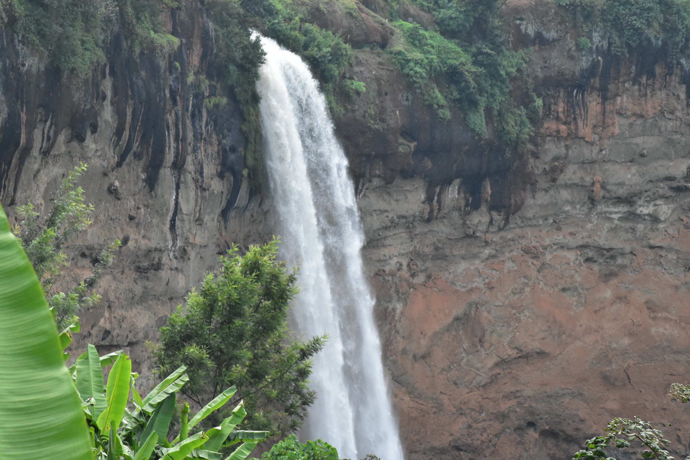
The route leaves Kisamba village and climbs through Bakonzo homesteads with views back toward the Kasese plain, then enters the lower equatorial rainforest fringing the Rwenzori foothills along the Sebwe river. The trail follows the river valley up past a sequence of waterfalls — described in secondary sources as a chain of about seven cascades — crossing wooden bridges and skirting steep banks. The upper falls form a sheltered amphitheatre of rock and forest with pools at their base. Walkers return by the same route. A shorter variant from the road reaches only the lower main fall, while the longer foothill hike continues up the chain of cascades.
Why it is essential
Sebwe Falls is the most accessible Rwenzori foothill walk that does not require a UWA hut or ranger booking, and the most readily-cited foothill waterfall objective in the range. It complements the in-park trails above by offering a low-altitude rainforest and river-canyon experience reachable without the Central Circuit logistics chain.
Equipment
Standard hiking equipment with grippy footwear, rain shell, warm layer, water, food, and insect protection. Trekking poles are useful on the wet sections. A local guide is widely advised.
Hazards and notes
The trail follows a steep river valley with several stream crossings; surfaces are slippery in wet weather and the river is exposed to rapid flow after heavy rain. There is no UWA ranger escort because the route lies outside the national park, but a local guide from Kisamba or Bugoye is widely advised. The trailhead sits north of the FCDO-advised strip south-west of Kasese town but still inside the wider Western Region area subject to the 2025-2026 cross-border security incidents and, as of mid-2026, the US Department of State Level 4 advisory for Uganda; both should be re-checked before travel.
GPX / KML links
| Source | URL |
|---|---|
| Visit Rwanda Gorilla — Sebwe Falls hike description | visitrwandagorilla.com |
| Kitara Foundation — Sebwe waterfalls hike | kitararcc.com |
| OpenStreetMap | openstreetmap.org |
5. Ruboni community hill walk and village trail
Snapshot
Itinerary
Ruboni Community Tourism Camp is the recognised community-tourism base at the entrance to Rwenzori Mountains National Park, owned and run by the Bakonzo community. The catalogued day-hike is a combined village and hill walk: the village section visits a homestead, blacksmith, traditional healer, and basket-weaver area in Ruboni over roughly 3 hours; the hill walk climbs from the village along forested ridges above the River Mubuku, with views of Baker and Portal Peaks and the lower Mubuku valley, to about 2,300 m before returning by the same line. The longer variant is sometimes catalogued as a full-day hill trek of about 6 hours.
Why it is essential
This route is the principal cultural-and-landscape hike of the Ugandan Rwenzori foothills. It introduces the Bakonzo community, whose homeland and cosmology centre on the range, and gives a Mubuku-valley perspective that complements the in-park forest hikes above. It is also the only catalogued route in this selection that is feasible without a UWA ranger escort or park-entry fee.
Equipment
Standard hiking equipment with grippy footwear, rain shell, warm layer, water, sun protection, and insect protection. A community guide arranged through Ruboni Community Tourism Camp is required; operator pricing is listed at USD 15 per person each for the village walk and the hill walk.
Hazards and notes
The trail is short and lower-altitude but still climbs into forest with mud, slick roots, and stream crossings. The route lies outside the national park but adjacent to the FCDO-advised strip south-west of Kasese town. As of mid-2026 the US Department of State Level 4 advisory for Uganda (Ebola-driven) is also in force and should be re-checked before travel.
GPX / KML links
| Source | URL |
|---|---|
| Ruboni Community Tourism Camp | rubonicamp.com |
| The Uganda Trips — Ruboni Community Camp activities and prices | theugandatrips.com |
| Rwenzori National Park — Nature walks | rwenzorinationalpark.com |
| OpenStreetMap | openstreetmap.org |
External links
| Source | URL |
|---|---|
| Uganda Wildlife Authority — Rwenzori Mountains National Park | ugandawildlife.org |
| UNESCO — Rwenzori Mountains National Park (site 684) | whc.unesco.org |
| World Heritage Datasheet — Rwenzori Mountains National Park | world-heritage-datasheets.unep-wcmc.org |
| Wikipedia — Rwenzori Mountains National Park | en.wikipedia.org |
| Wikipedia — Rwenzori Mountains | en.wikipedia.org |
| Wikipedia — Mount Stanley | en.wikipedia.org |
| Rwenzori Mountaineering Service (Central Circuit operator) | rwenzorimountaineeringservice.com |
| Rwenzori Trekking Services (Kilembe Trail operator) | rwenzoritrekking.com |
| Bujuku Eco Tours — 1-day Rwenzori hike to Lake Mahoma | bujukuecotours.com |
| Rwenzori Trekking Services — 1-day trek to Nyabitaba Hut | rwenzoritrekkingservices.com |
| Rwenzori Mountaineering Service — 1-day Kilembe Trail trek | rwenzorimountaineeringservice.com |
| Ruboni Community Tourism Camp | rubonicamp.com |
| Visit Rwanda Gorilla — Sebwe Falls | visitrwandagorilla.com |
| Kitara Foundation — Sebwe waterfalls hike | kitararcc.com |
| AllTrails — Rwenzori National Park | alltrails.com |
| Wikimedia Commons — Category:Rwenzori Mountains National Park | commons.wikimedia.org |
| Wikimedia Commons — Category:Ruwenzori Range | commons.wikimedia.org |
| UNESCO State of Conservation 2025 — Virunga National Park, DRC | whc.unesco.org |
| US Department of State — Uganda Travel Advisory | travel.state.gov |
| UK Government — Uganda foreign travel advice | gov.uk |
| OpenStreetMap | openstreetmap.org |