Regional overview
The Tibesti Mountains are one of the Sahara’s most remote volcanic mountain systems, centred in northern Chad with extensions toward Libya. Key names include Emi Koussi, Trou au Natron, Tarso Tousside, Bardai, and a network of volcanic plateaus, calderas, wadis, and oasis settlements.
This is not a normal public day-hiking region. In this pass, no reliable public walking GPX sources with day-hike statistics were resolved for the core Tibesti objectives. The entries below are therefore high-detail candidate routes: they identify the essential walking objectives and the verification work needed, but they do not invent distance, ascent, or GPX data.
Selection rationale
The five candidates cover the region’s obvious essentials: the Sahara high point Emi Koussi, the Trou au Natron volcanic viewpoint, Tarso Tousside, a Bardai oasis escarpment walk, and a sandstone/wadi route representing the non-summit Tibesti landscape. All remain candidate-only because public route statistics were not defensible in this pass.
Summary table
| # | Hike | Country | Route type | Distance | Gain | Max elevation | Difficulty | Photo status |
|---|---|---|---|---|---|---|---|---|
| 1 | Emi Koussi crater-rim candidate route | Chad | Out-and-back / expedition day section | 3,415 m according to Mountain Planet; Peakbagger lists 3,445 m for Emi Koussi | Candidate only — strenuous expedition objective | No licence-compatible image found in this pass | ||
| 2 | Trou au Natron viewpoint candidate route | Chad | Out-and-back / viewpoint walk | Candidate only | No licence-compatible image found in this pass | |||
| 3 | Tarso Tousside volcanic candidate route | Chad | Out-and-back / volcanic plateau walk | Candidate only | No licence-compatible image found in this pass | |||
| 4 | Bardai oasis escarpment candidate walk | Chad | Out-and-back / local loop | Candidate only | No licence-compatible image found in this pass | |||
| 5 | Tibesti sandstone-and-wadi candidate route | Chad / Libya | Out-and-back / local loop | Candidate only | No licence-compatible image found in this pass |
1. Emi Koussi crater-rim candidate route
Snapshot
Itinerary
The candidate objective is a guided ascent or crater-rim day section on Emi Koussi, the signature high volcano of the Tibesti and the Sahara high point. Mountain Planet identifies it as a hiking/mountaineering objective and gives an elevation of 3,415 m; Peakbagger’s range page lists Emi Koussi as the Tibesti high point at 3,445 m.
A publication-ready route must identify the normal approach camp, walking start point, ascent line, crater-rim turnaround, descent line, and realistic time. Without that data, this is an essential objective but not a route-ready hike.
Why it is essential
Emi Koussi is the headline mountain of the Tibesti and one of the most important volcanic objectives in the Sahara.
Equipment
- Desert-capable day-hiking kit: broken-in boots or approach shoes, sun hat, sunglasses, high-SPF sunscreen, and light long sleeves.
- Large water carry. Treat 3-5 litres as a planning floor for moderate days and more for hot, exposed, or remote routes.
- Offline navigation, paper/map backup where available, power bank, headlamp, first-aid kit, and emergency shelter layer.
- Food, electrolyte salts, warm layer for high plateaus, and windproof layer for exposed ridges.
- Local guide or locally verified access plan where protected-area, border, military, or remote-desert rules apply.
Hazards and notes
- Heat, dehydration, sun exposure, and very long distances between reliable water points.
- Weak or absent waymarking; GPS tracks may describe an individual recording rather than a maintained trail.
- Flash-flood risk in wadis and canyons after storms, even where the surrounding desert is dry.
- Remote rescue context: phone coverage, road access, and local transport options may be poor or absent.
- Current access, guide, permit, and security conditions must be checked locally before publication or field use.
- Extreme remoteness, altitude, volcanic terrain, and unresolved access/security logistics.
- Elevation sources differ; final guide should standardise on one authoritative elevation.
Photos
Photo status: No licence-compatible image found in this pass.
| Image | Source | Author | Licence | Reuse notes | Attribution |
|---|---|---|---|---|---|
| Unresolved | Unresolved | Unresolved | Unresolved | No verified reusable photo candidate found | Unresolved |
GPX / KML links
| Source | URL | Format | Licence / terms | Reuse status |
|---|---|---|---|---|
| Unresolved | Unresolved | Unresolved | Unresolved | No route file found in this pass |
External links
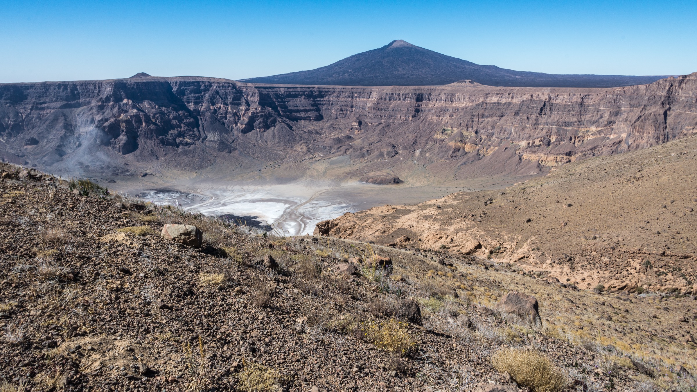
2. Trou au Natron viewpoint candidate route
Snapshot
Itinerary
The candidate route would walk from a 4WD-supported camp or track end to a safe viewpoint over Trou au Natron, the striking white volcanic depression associated with the Tousside volcanic area.
The final guide needs a confirmed safe viewpoint line. Rim terrain, unstable slopes, and vehicle approach points must be checked with specialist local operators or field GPS data.
Why it is essential
Trou au Natron is one of the defining visual landmarks of the Tibesti: volcanic, remote, and unlike conventional mountain scenery.
Equipment
- Desert-capable day-hiking kit: broken-in boots or approach shoes, sun hat, sunglasses, high-SPF sunscreen, and light long sleeves.
- Large water carry. Treat 3-5 litres as a planning floor for moderate days and more for hot, exposed, or remote routes.
- Offline navigation, paper/map backup where available, power bank, headlamp, first-aid kit, and emergency shelter layer.
- Food, electrolyte salts, warm layer for high plateaus, and windproof layer for exposed ridges.
- Local guide or locally verified access plan where protected-area, border, military, or remote-desert rules apply.
Hazards and notes
- Heat, dehydration, sun exposure, and very long distances between reliable water points.
- Weak or absent waymarking; GPS tracks may describe an individual recording rather than a maintained trail.
- Flash-flood risk in wadis and canyons after storms, even where the surrounding desert is dry.
- Remote rescue context: phone coverage, road access, and local transport options may be poor or absent.
- Current access, guide, permit, and security conditions must be checked locally before publication or field use.
- Volcanic rim/drop hazards and uncertain footing.
- No public route statistics or route file were resolved.
Photos
Photo status: No licence-compatible image found in this pass.
| Image | Source | Author | Licence | Reuse notes | Attribution |
|---|---|---|---|---|---|
| Unresolved | Unresolved | Unresolved | Unresolved | No verified reusable photo candidate found | Unresolved |
GPX / KML links
| Source | URL | Format | Licence / terms | Reuse status |
|---|---|---|---|---|
| Unresolved | Unresolved | Unresolved | Unresolved | No route file found in this pass |
External links
3. Tarso Tousside volcanic candidate route
Snapshot
Itinerary
A final version of this route should choose a single day section on the Tarso Tousside volcanic system: a summit shoulder, crater viewpoint, or plateau rim that can be walked safely from a camp or 4WD drop.
No defensible public walking statistics were found in this pass, so the route remains a structured placeholder for future field-sourced or operator-sourced data.
Why it is essential
Tarso Tousside is one of the great volcanic names of the Tibesti and pairs naturally with Trou au Natron in any regional catalogue.
Equipment
- Desert-capable day-hiking kit: broken-in boots or approach shoes, sun hat, sunglasses, high-SPF sunscreen, and light long sleeves.
- Large water carry. Treat 3-5 litres as a planning floor for moderate days and more for hot, exposed, or remote routes.
- Offline navigation, paper/map backup where available, power bank, headlamp, first-aid kit, and emergency shelter layer.
- Food, electrolyte salts, warm layer for high plateaus, and windproof layer for exposed ridges.
- Local guide or locally verified access plan where protected-area, border, military, or remote-desert rules apply.
Hazards and notes
- Heat, dehydration, sun exposure, and very long distances between reliable water points.
- Weak or absent waymarking; GPS tracks may describe an individual recording rather than a maintained trail.
- Flash-flood risk in wadis and canyons after storms, even where the surrounding desert is dry.
- Remote rescue context: phone coverage, road access, and local transport options may be poor or absent.
- Current access, guide, permit, and security conditions must be checked locally before publication or field use.
- Volcanic rock, unstable ground, and remote navigation.
- Route, distance, ascent, and access are all unresolved.
Photos
Photo status: No licence-compatible image found in this pass.
| Image | Source | Author | Licence | Reuse notes | Attribution |
|---|---|---|---|---|---|
| Unresolved | Unresolved | Unresolved | Unresolved | No verified reusable photo candidate found | Unresolved |
GPX / KML links
| Source | URL | Format | Licence / terms | Reuse status |
|---|---|---|---|---|
| Unresolved | Unresolved | Unresolved | Unresolved | No route file found in this pass |
External links
4. Bardai oasis escarpment candidate walk
Snapshot
Itinerary
This candidate would be the most human-scale route in the Tibesti set: a local walk from Bardai or a nearby oasis settlement to an escarpment or wadi viewpoint, then return.
The final route should be designed with local permission and cultural sensitivity first. Because no public track was found, the entry remains a catalogue placeholder for a future locally verified route.
Why it is essential
A Tibesti catalogue should not contain only volcanoes. Bardai represents oasis settlement, escarpment walking, and the inhabited side of the range.
Equipment
- Desert-capable day-hiking kit: broken-in boots or approach shoes, sun hat, sunglasses, high-SPF sunscreen, and light long sleeves.
- Large water carry. Treat 3-5 litres as a planning floor for moderate days and more for hot, exposed, or remote routes.
- Offline navigation, paper/map backup where available, power bank, headlamp, first-aid kit, and emergency shelter layer.
- Food, electrolyte salts, warm layer for high plateaus, and windproof layer for exposed ridges.
- Local guide or locally verified access plan where protected-area, border, military, or remote-desert rules apply.
Hazards and notes
- Heat, dehydration, sun exposure, and very long distances between reliable water points.
- Weak or absent waymarking; GPS tracks may describe an individual recording rather than a maintained trail.
- Flash-flood risk in wadis and canyons after storms, even where the surrounding desert is dry.
- Remote rescue context: phone coverage, road access, and local transport options may be poor or absent.
- Current access, guide, permit, and security conditions must be checked locally before publication or field use.
- Private/local land and cultural access sensitivity.
- No public route statistics or route file were resolved.
Photos
Photo status: No licence-compatible image found in this pass.
| Image | Source | Author | Licence | Reuse notes | Attribution |
|---|---|---|---|---|---|
| Unresolved | Unresolved | Unresolved | Unresolved | No verified reusable photo candidate found | Unresolved |
GPX / KML links
| Source | URL | Format | Licence / terms | Reuse status |
|---|---|---|---|---|
| Unresolved | Unresolved | Unresolved | Unresolved | No route file found in this pass |
External links
5. Tibesti sandstone-and-wadi candidate route
Snapshot
Itinerary
This placeholder is for the Tibesti’s non-volcanic walking character: wadi floors, sandstone margins, oasis approaches, and escarpment viewpoints. A final route should be selected only after a guide or field source provides a safe, legal day-walk line.
The Chad-Libya range label makes this especially sensitive: cross-border or border-adjacent route suggestions should not be made without current official access information.
Why it is essential
The Tibesti is broader than its famous volcanoes. A wadi/sandstone route would round out the final catalogue by showing the range’s desert walking texture.
Equipment
- Desert-capable day-hiking kit: broken-in boots or approach shoes, sun hat, sunglasses, high-SPF sunscreen, and light long sleeves.
- Large water carry. Treat 3-5 litres as a planning floor for moderate days and more for hot, exposed, or remote routes.
- Offline navigation, paper/map backup where available, power bank, headlamp, first-aid kit, and emergency shelter layer.
- Food, electrolyte salts, warm layer for high plateaus, and windproof layer for exposed ridges.
- Local guide or locally verified access plan where protected-area, border, military, or remote-desert rules apply.
Hazards and notes
- Heat, dehydration, sun exposure, and very long distances between reliable water points.
- Weak or absent waymarking; GPS tracks may describe an individual recording rather than a maintained trail.
- Flash-flood risk in wadis and canyons after storms, even where the surrounding desert is dry.
- Remote rescue context: phone coverage, road access, and local transport options may be poor or absent.
- Current access, guide, permit, and security conditions must be checked locally before publication or field use.
- Border/security sensitivity and no public walking route data.
- Potential for flash floods, navigation error, and inaccessible rescue.
Photos
Photo status: No licence-compatible image found in this pass.
| Image | Source | Author | Licence | Reuse notes | Attribution |
|---|---|---|---|---|---|
| Unresolved | Unresolved | Unresolved | Unresolved | No verified reusable photo candidate found | Unresolved |
GPX / KML links
| Source | URL | Format | Licence / terms | Reuse status |
|---|---|---|---|---|
| Unresolved | Unresolved | Unresolved | Unresolved | No route file found in this pass |
External links
Missing data and follow-up
- No reliable public walking GPX/KML/source-route files were found for the five Tibesti candidate routes.
- Distance, ascent, descent, walking time, trailheads, and exact day-route geometry remain unresolved for every Tibesti candidate.
- Current permits, access, guide requirements, security situation, and cross-border constraints must be checked with official/local sources before publication.
- No licence-compatible photos were verified for these five routes.
- Future work should prioritise specialist expedition operators, official/local authorities, field GPS logs, and open-licence imagery.
External links
| Source | URL |
|---|---|
| Mountain Planet — Emi Koussi | mountainplanet.com |
| Peakbagger — Tibesti range | peakbagger.com |
| TakeYourBackpack — Tibesti Mountains | takeyourbackpack.com |
| AllTrails connector search for Emi Koussi | Returned unrelated results; no usable AllTrails source found |