Regional overview
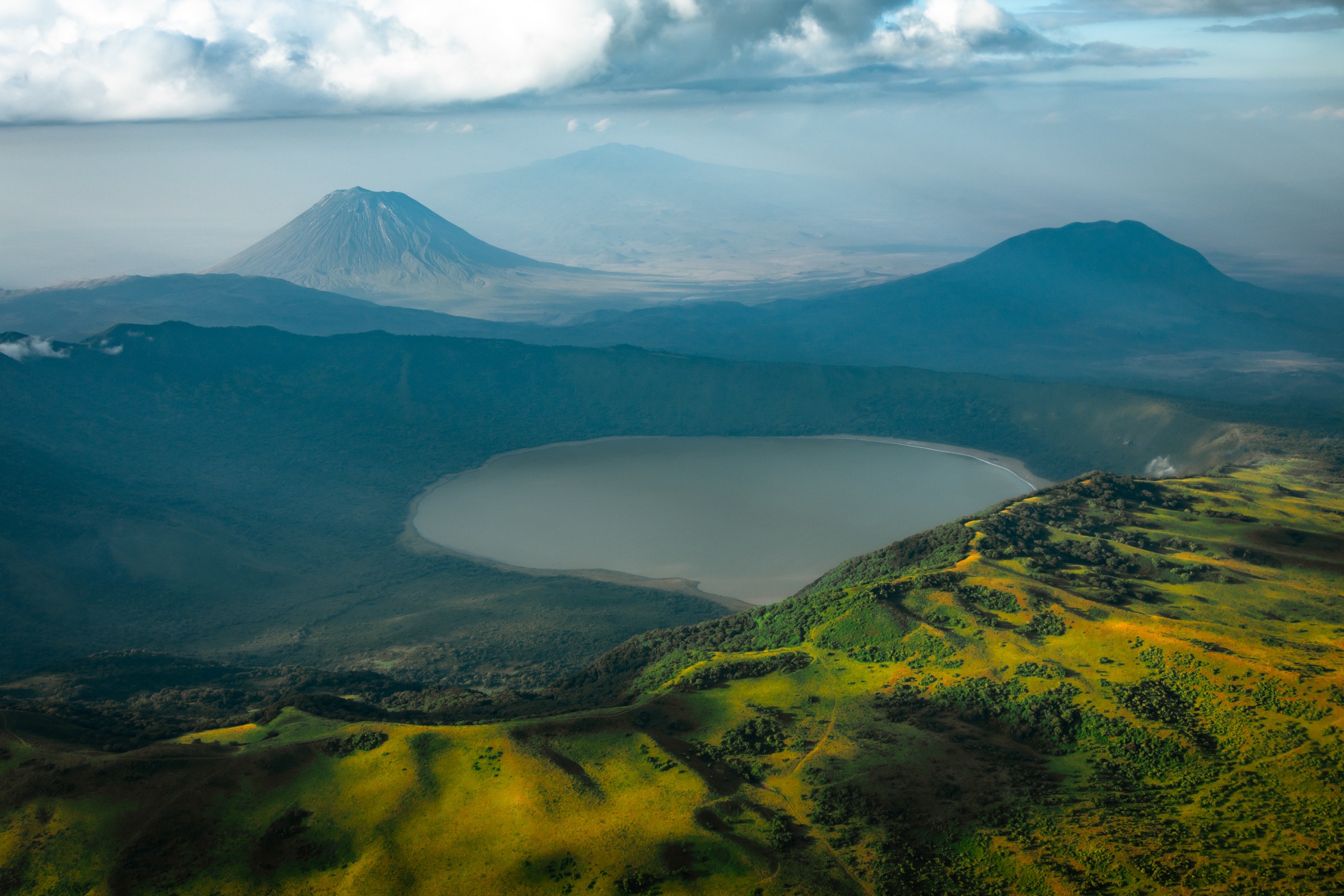
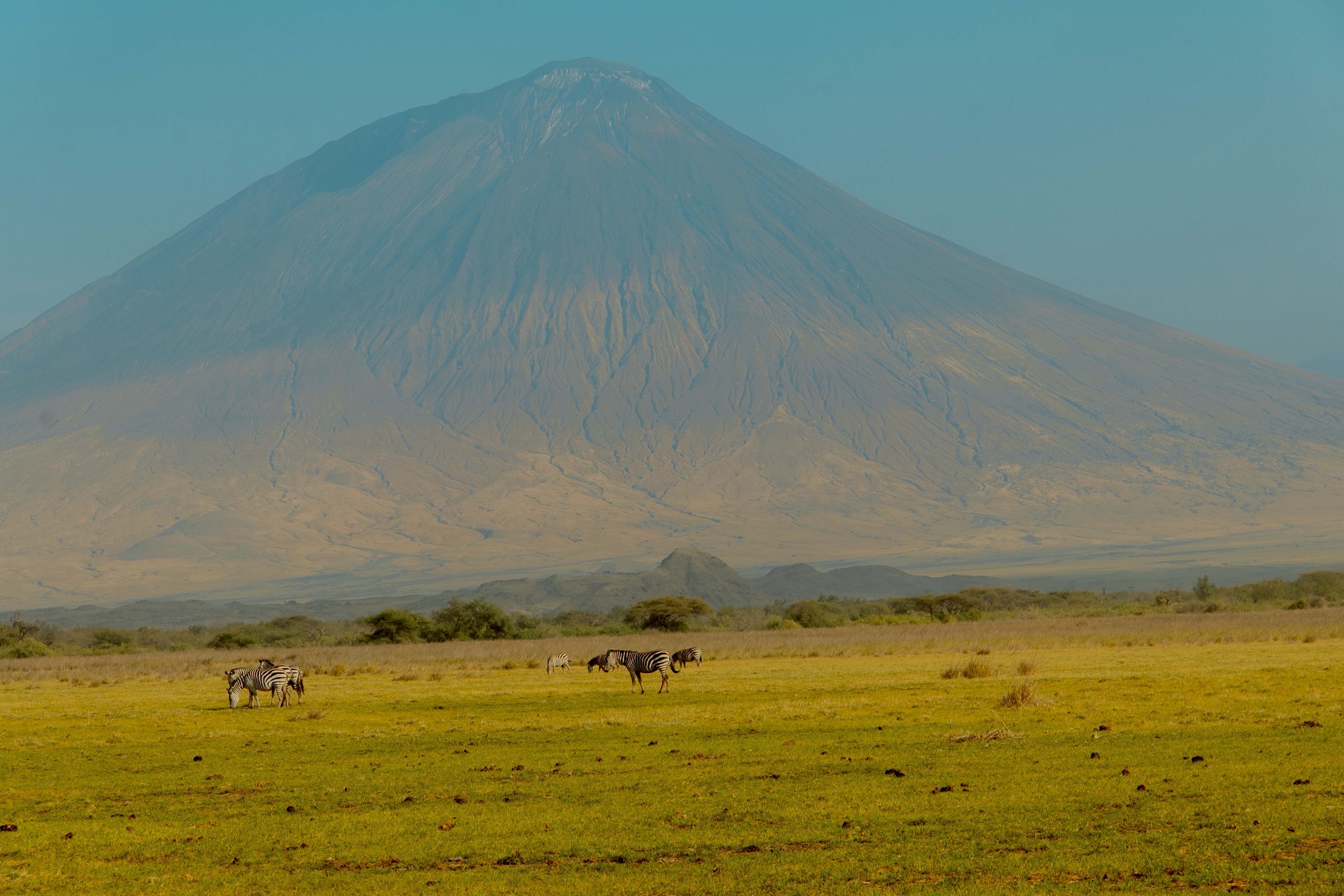
The Crater Highlands form a chain of volcanoes and collapsed calderas on the eastern branch of the East African Rift in northern Tanzania, immediately west of the Rift escarpment and the Lake Natron depression. The complex includes the Ngorongoro Caldera (rim 2,200-2,400 m, floor about 1,800 m), Olmoti (3,080 m), Empakaai (rim 2,590-3,200 m), Lemagrut (about 3,122-3,130 m), Sadiman, Oldeani and Mount Loolmalasin (3,682 m, the third-highest mountain in Tanzania). Ol Doinyo Lengai (2,962 m), the only active carbonatite volcano in the world, stands isolated to the north-east of the main massif above the Rift floor near Lake Natron. The entire area lies within the Ngorongoro Conservation Area (NCA), inscribed by UNESCO as a World Heritage Site in 1979 under all four natural criteria and re-recognised as the Ngorongoro Lengai UNESCO Global Geopark in 2018.
The hiking character is volcanic, high-grassland, semi-forested on the upper rims and Afro-alpine on the highest summits, opening abruptly to the Rift floor and Maasai grazing country to the east. The Ngorongoro Conservation Area Authority (NCAA) is the principal management body. NCAA rules require an armed ranger escort for all walking activities in the conservation area because of lion, buffalo and elephant presence; hiking inside the Ngorongoro Caldera floor itself is not permitted. Walks must be booked through NCAA headquarters at Park Village or arranged via an accredited lodge or operator. Ol Doinyo Lengai sits within the Geopark area but outside the NCA proper and is climbed with local Engaresero village guides plus a Lake Natron Wildlife Management Area fee structure that is separate from NCA entry.
The standard hiking window is the long dry season from June to October, with a shorter dry window in January-February. The long rains from March to May make the highland tracks deeply muddy and the volcanic ash slopes on Lengai dangerous. Daytime highland temperatures are mild (often 15-22 degC) but nights and dawns are cold, with frost possible on the highest rims. Dust, sun and altitude (most summits above 2,800 m) are the recurring planning issues. Lengai’s last documented eruption was in 2024 and the volcano is monitored by GNSS and seismometer; ascent status can change without notice and should be re-checked with local operators before departure.
Access is by 4x4 from Arusha (180-200 km to the Ngorongoro Loduare Gate, 3-4 hours) or by light aircraft to Lake Manyara or Lake Natron airstrips. There is no scheduled public transport into the conservation area; almost all visitors arrive by safari vehicle, private transfer or organised trek logistics with overnights at Simba A campsite (Ngorongoro rim), Nainokanoka (Olmoti) or Empakaai rim campsites. Lemagrut, Olmoti, Empakaai and Lengai are all routinely combined into a multi-day Crater Highlands traverse on foot with mule support, with the individual ascents listed below being the standard day sections.
Selection rationale
The five hikes span the Crater Highlands’ most representative day routes across the central NCA, the Geopark area and the active rift volcanoes, while keeping each route inside day-hike constraints. Where a route is in practice operated as part of a multi-day Crater Highlands traverse (Empakaai, Lemagrut) the listed section is the recognised single-day component. Empakaai is the defining short walk of the highlands to a soda-lake floor; Olmoti is the standard short crater walk from Nainokanoka, with the headwaters that feed the Ngorongoro Caldera floor; the Ngorongoro Caldera rim walk is the recognised rim traverse with the panoramic caldera views (hiking inside the caldera is prohibited so the rim is the only legal walking option); Ol Doinyo Lengai is the active soda-volcano summit, routinely sold and recorded as a single ascent-and-return day; and Mount Lemagrut is the highest day-walked peak of the western highlands, with the panoramic view across the Serengeti, Lake Eyasi and the Ngorongoro Caldera.
Summary table
| # | Hike | Country | Route type | Distance | Gain | Max elevation | Difficulty |
|---|---|---|---|---|---|---|---|
| 1 | Empakaai Crater rim-to-lake descent | Tanzania | Out-and-back | 4-5 km | 274-300 m | 2,510 m | Moderate |
| 2 | Olmoti Crater rim and Munge Waterfall | Tanzania | Out-and-back | 3 km | 300-310 m | 3,080 m | Easy-Moderate |
| 3 | Ngorongoro Caldera rim walk (Lemala-Sopa sector) | Tanzania | Out-and-back or point-to-point | 4-20 km | Rolling | 2,400 m | Easy-Moderate |
| 4 | Ol Doinyo Lengai dawn ascent | Tanzania | Out-and-back | 12-13 km | 1,600 m | 2,962 m | Very Hard |
| 5 | Mount Lemagrut summit | Tanzania | Out-and-back | 4 h round trip | Rolling | 3,122-3,130 m | Moderate |
1. Empakaai Crater rim-to-lake descent
Snapshot
Itinerary
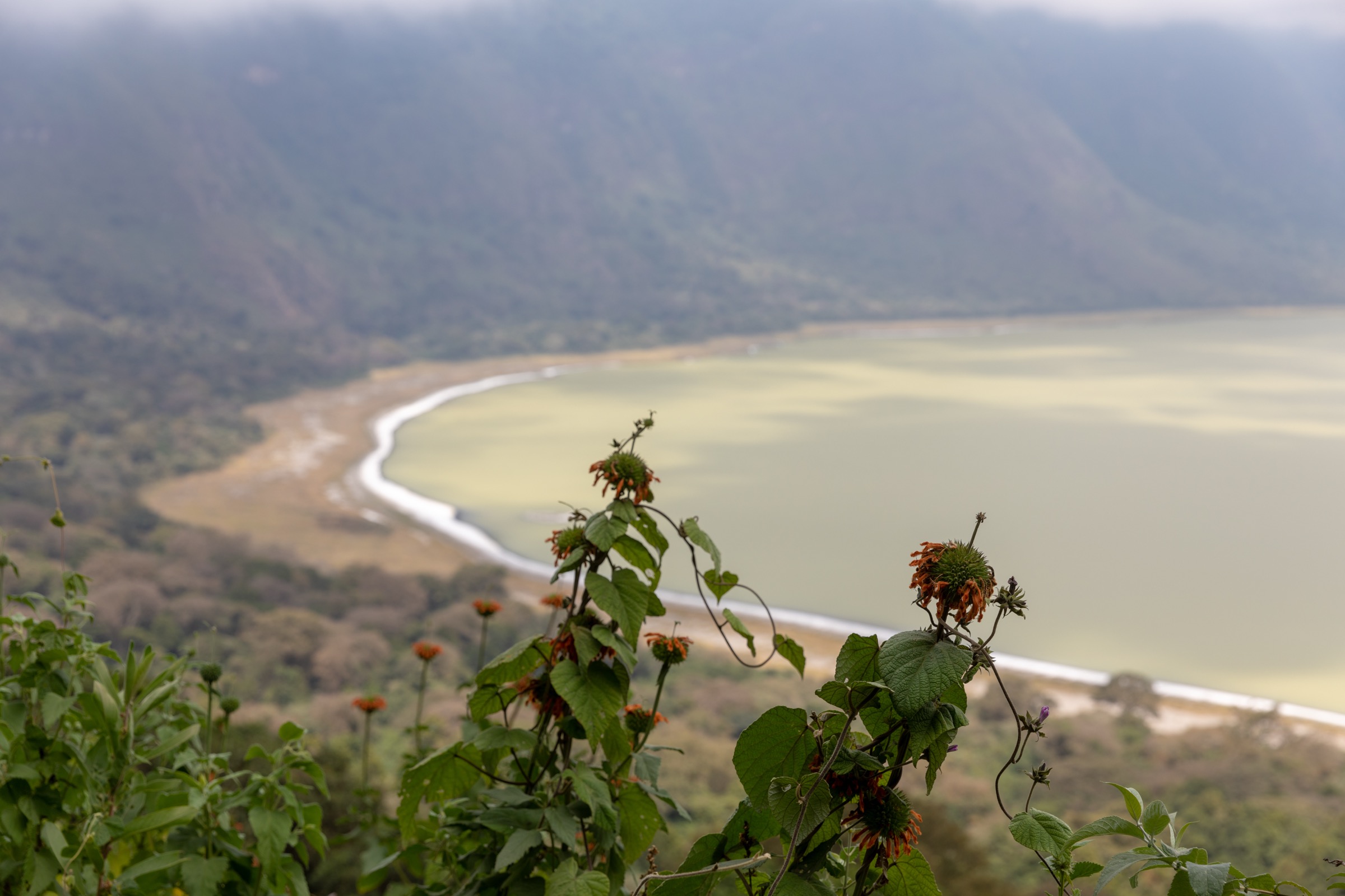
The route starts at the Empakaai rim campsite area on the western side of the caldera at roughly 2,470-2,510 m at the standard viewpoint. The footpath descends through a forested cliff belt of strangler figs and montane forest down to the soda-lake shore at about 2,200-2,232 m on the crater floor. The descent typically takes 30-45 minutes. The lake shore offers views of open water, soda crust at the margins, and seasonal flamingo flocks, with Ol Doinyo Lengai visible to the north-east on clear days. The return follows the same path back to the rim and takes 60-90 minutes for most walkers because of the sustained climb.
Why it is essential
Empakaai is the defining accessible day walk of the Crater Highlands. It is the only crater in the highlands where a footpath is legally open to the floor, it gives a direct view of an active rift soda lake, and it is the route most consistently cited by NCAA, UNESCO Geopark descriptions and walking-safari operators as the signature Crater Highlands hike. It also provides the standard staging point for any multi-day traverse linking Olmoti, Empakaai, Loolmalasin and Lengai.
Equipment
Mountain hiking kit as a baseline: sturdy boots with grip, weatherproof shell, warm layer for cold rim mornings, sun protection, water (no safe lake water for drinking), and a headlamp for dawn or dusk margins. Trekking poles are strongly recommended for the descent. NCAA conservation-area entry fee, walking-activity fee, and an armed ranger escort must be organised in advance through NCAA or an operator.
Hazards and notes
The descent track is steep with loose ground and slippery roots in wet weather. Buffalo, hyena and occasional elephant are present in the forested rim belt, which is the reason an armed ranger is required. Altitude effects are limited at 2,200-2,500 m but cold mornings, mist and persistent cloud are common, and views of Lengai are not guaranteed. The lake water is alkaline and not potable. Permits and ranger arrangements must be confirmed in advance because walk-up access is not standard.
GPX / KML links
| Source | URL |
|---|---|
| Wikiloc: Empakai Crater Trail | wikiloc.com |
| Hiking Adventures: Hike 090 Empakaai Crater | hikingadventures.net |
| NCAA: Empakai Crater official page | ncaa.go.tz |
2. Olmoti Crater rim and Munge Waterfall
Snapshot
Itinerary
The route starts at Nainokanoka village at the eastern foot of Olmoti. A well-developed trail climbs through highland grassland and acacia scrub onto the southern side of the volcano, reaching the rim of the shallow grassed-floor caldera (about 6.5 km in diameter) in 30-40 minutes. From the rim a short side path leads to a viewpoint over the Munge Waterfall on the western edge of the crater, where the Munge River exits the caldera and falls towards Ngorongoro and Lake Magadi. Return is by the same route. The crater floor itself is a broad grassland with seasonal water that supports buffalo and eland; entry to the floor is not part of the standard short walk.
Why it is essential
Olmoti is the standard short rim walk of the central highlands and the headwater that physically feeds the Ngorongoro Caldera floor through the Munge River. It is the only signposted crater walk in the central NCA short enough to be combined with the Empakaai descent in a single day from Nainokanoka, and it provides a contrasting grassland-crater experience to Empakaai’s wooded soda-lake basin.
Equipment
Standard hiking equipment is sufficient: sturdy shoes or light boots, weatherproof shell, warm layer, sun protection, water. NCAA conservation-area entry, walking-activity fee, and an armed ranger escort are mandatory and must be organised through NCAA or an operator.
Hazards and notes
The hike is short but the climb is sustained. The rim and crater floor host buffalo and other wildlife; an armed ranger escort is mandatory. Frost is possible on the rim in the cold dry season at dawn. The Munge waterfall viewpoint is unfenced and care is required near the edge. Local weather changes quickly at 3,000 m and the rim can cloud over with little warning.
GPX / KML links
| Source | URL |
|---|---|
| NCAA: Olmoti Crater official page | ncaa.go.tz |
| Journey Era: Olmoti Crater Hike | journeyera.com |
| Expert Africa: Olmoti Crater walk | expertafrica.com |
3. Ngorongoro Caldera rim walk (Lemala-Sopa sector)
Snapshot
Itinerary
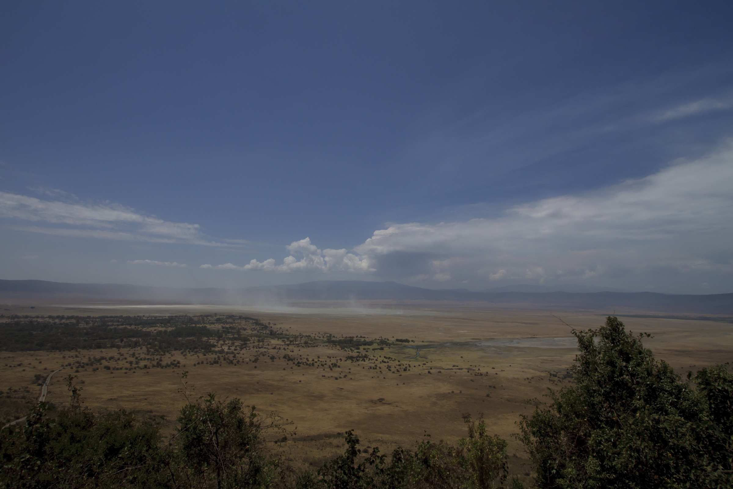
The standard short rim walk starts from the Lemala or Sopa area on the eastern rim at about 2,400 m and follows a Maasai cattle trail along the open rim crest through acacia woodland and montane thicket, with several viewpoints over the caldera floor roughly 600 m below. The walk passes Maasai grazing pastures on the outward slopes of the rim and gives panoramic views over the caldera lakes, the Lerai forest and the surrounding highland. Longer variants follow the rim northwards on the drier side towards the upper Munge drainage and the Olmoti foothills; the 20 km northern-rim walking-safari section ends at a fly-camp or lodge on the rim below Olmoti. Hiking inside the caldera floor is not permitted; the rim is the only legal walking line.
Why it is essential
The rim walk is the only legal foot route around the world’s largest unflooded volcanic caldera. It is consistently cited by NCAA, UNESCO and walking-safari operators as the standard non-vehicle way to experience the Ngorongoro landscape, gives the canonical views of the caldera floor used in the IUCN site description, and links the eastern rim to the central highlands via the Munge drainage.
Equipment
Standard hiking equipment: sturdy walking shoes or light boots, weatherproof shell, warm layer for cold rim mornings, sun protection, water, headtorch for early starts. NCAA conservation-area entry and walking-activity fee are required; an armed ranger escort is mandatory on all walking activities in the conservation area.
Hazards and notes
The rim trail is unfenced in places and is shared with Maasai cattle. Buffalo and elephant are regularly present in the rim forest belt, which is the reason for the armed-ranger requirement. Dawn temperatures can be near freezing and mist on the rim is common. The descent road into the caldera is for vehicles only; do not attempt to walk into the caldera floor.
GPX / KML links
| Source | URL |
|---|---|
| Expert Africa: Crater Rim Walk | expertafrica.com |
| NCAA: Tourism Activities | ncaa.go.tz |
| Ngorongoro Crater Tanzania: Rim Walk | ngorongorocratertanzania.org |
4. Ol Doinyo Lengai dawn ascent
Snapshot
Itinerary
Climbs start in the dark, usually around midnight, from the trailhead at the western foot of the volcano. The route follows a dry water-cut gulley and ridge system on the western flank, rising on increasingly steep volcanic ash. The lower section is moderate; from roughly the half-height point the gradient steepens consistently to about 30 degrees, with rocky benches between ash slopes. The final section above about 2,500 m is a sustained scramble on hard volcanic crust with exposed sections. Summit arrival is timed for dawn around 06:00-07:00 to see the small active vent area within the summit crater (subject to current activity status) and the sunrise over Lake Natron, Mount Kerimasi, the southern Crater Highlands and the Rift escarpment. Descent is by the same route in daylight and is technical because of the loose ash and dust.
Why it is essential
Ol Doinyo Lengai is the only known active carbonatite volcano on the planet and the iconic rift-edge summit beside the Crater Highlands proper. It is internationally recognised as the geological centrepiece of the Ngorongoro-Lengai UNESCO Global Geopark. Although it is in practice a serious overnight-start mountain rather than a casual day hike, it is consistently sold and recorded as a single ascent-and-return day from Engaresero and is the highland’s defining summit experience.
Equipment
Mountain hiking equipment with summit-specific additions: sturdy boots with good ankle support and grip, dust-resistant gaiters strongly recommended, weatherproof shell, warm layer for the cold pre-dawn summit, gloves and a buff for ash dust, sun protection for the daytime descent, a headlamp (mandatory) with spare batteries, trekking poles strongly recommended, and at least 3-4 litres of water per person. A local Engaresero village guide is required by Wildlife Management Area arrangement. Lake Natron Wildlife Management Area entry and village guide fees are separate from NCA fees; check current rates with the village office before travel.
Hazards and notes
The route is on a periodically active volcano. The most recent documented eruption was in 2024 and renewed activity can close the summit at short notice; current eruptive status should be checked with local guides before committing. The ash slope is dangerous on descent in the wet season and in any rain. Heat exhaustion on the daytime descent is a serious risk; dust and dehydration are routine. There are no fixed protections or emergency facilities on the mountain. The summit crater rim is unstable; do not attempt to descend into the active vent area. The Engaresero / Lake Natron area is a Wildlife Management Area with separate fee, guide and access rules from the NCA; confirm with local sources before travel.
GPX / KML links
| Source | URL |
|---|---|
| Wikiloc: Ol Doinyo Lengai | wikiloc.com |
| AllTrails: Ol Doinyo Lengai | alltrails.com |
| Hiking Adventures: Hike 079 Ol Doinyo Lengai | hikingadventures.net |
5. Mount Lemagrut summit
Snapshot
Itinerary
The standard hike starts on the western flank of Lemagrut after a 4x4 approach across the western highland from the Ngorongoro rim road. The route follows Maasai grazing tracks and open volcanic grassland with intermittent thorn scrub up the southern shoulder of the mountain. The summit is a broad, gently sloped grassland top at 3,122-3,130 m with panoramic views west over the Serengeti plains, south to Lake Eyasi, north to the Ngorongoro Caldera and east to the Olmoti-Empakaai-Loolmalasin axis. Return is by the same route. Lemagrut is also commonly walked as the western end of a multi-day Crater Highlands traverse joining Olmoti and Empakaai.
Why it is essential
Lemagrut is the highest day-walked peak of the western highlands and gives the recognised long view across the Serengeti, Lake Eyasi and the caldera. It is the standard scenic counterpoint to the rim walk on the eastern side and rounds out the day-hike set with a true summit rather than a crater walk or descent.
Equipment
Standard hiking equipment with mountain additions: sturdy boots (the thorn scrub on the lower slopes penetrates light shoes), weatherproof shell, warm layer, sun protection, water, headtorch. NCAA conservation-area entry, walking-activity fee, and an armed ranger escort are mandatory because of lion and buffalo presence on the route.
Hazards and notes
Lion and buffalo are routinely cited as hazards on the Lemagrut route, and the armed ranger escort is non-negotiable. Thorn scrub damages light footwear. The mountain is exposed at altitude and weather can change quickly. There are no facilities and no water on the route. Confirm current NCAA access rules and any seasonal closures with operators in advance.
GPX / KML links
| Source | URL |
|---|---|
| Tranquil Kilimanjaro: Mount Lemagrut | tranquilkilimanjaro.com |
| Shadows of Africa: Mount Lemargut Trekking | shadowsofafrica.com |
| Explorer Kenya: Ngorongoro highlands hiking trails | explorerkenya.com |
External links
| Source | URL |
|---|---|
| UNESCO World Heritage Centre — Ngorongoro Conservation Area | whc.unesco.org |
| UNESCO IGGP — Ngorongoro Lengai UNESCO Global Geopark | unesco.org |
| Ngorongoro Conservation Area Authority — main site | ncaa.go.tz |
| NCAA — Tourism Activities | ncaa.go.tz |
| NCAA — Visitor Guidelines and Procedures | ncaa.go.tz |
| NCAA — Empakai Crater | ncaa.go.tz |
| NCAA — Olmoti Crater | ncaa.go.tz |
| NCAA — Geopark | ncaa.go.tz |
| Wikipedia — Ngorongoro Crater | en.wikipedia.org |
| Wikipedia — Empakaai Crater | en.wikipedia.org |
| Wikipedia — Olmoti Crater | en.wikipedia.org |
| Wikipedia — Ol Doinyo Lengai | en.wikipedia.org |
| Wikipedia — Mount Loolmalasin | en.wikipedia.org |
| Hiking Adventures — Hike 090 Empakaai Crater | hikingadventures.net |
| Hiking Adventures — Hike 079 Ol Doinyo Lengai | hikingadventures.net |
| Wikiloc — Empakai Crater Trail | wikiloc.com |
| Wikiloc — Ol Doinyo Lengai | wikiloc.com |
| AllTrails — Ol Doinyo Lengai | alltrails.com |
| Journey Era — Empakaai Crater Hike | journeyera.com |
| Journey Era — Olmoti Crater Hike | journeyera.com |
| Expert Africa — Crater Rim Walk | expertafrica.com |
| Expert Africa — Olmoti Crater walk | expertafrica.com |
| Expert Africa — Empakaai Crater Hike | expertafrica.com |
| Tranquil Kilimanjaro — Mount Lemagrut | tranquilkilimanjaro.com |
| Shadows of Africa — Mount Lemargut Trekking | shadowsofafrica.com |
| Tanzania Tourism Board | tanzaniatourism.com |
| Wikimedia Commons — Ngorongoro Conservation Area category | commons.wikimedia.org |
| Wikimedia Commons — Ol Doinyo Lengai category | commons.wikimedia.org |