Regional overview
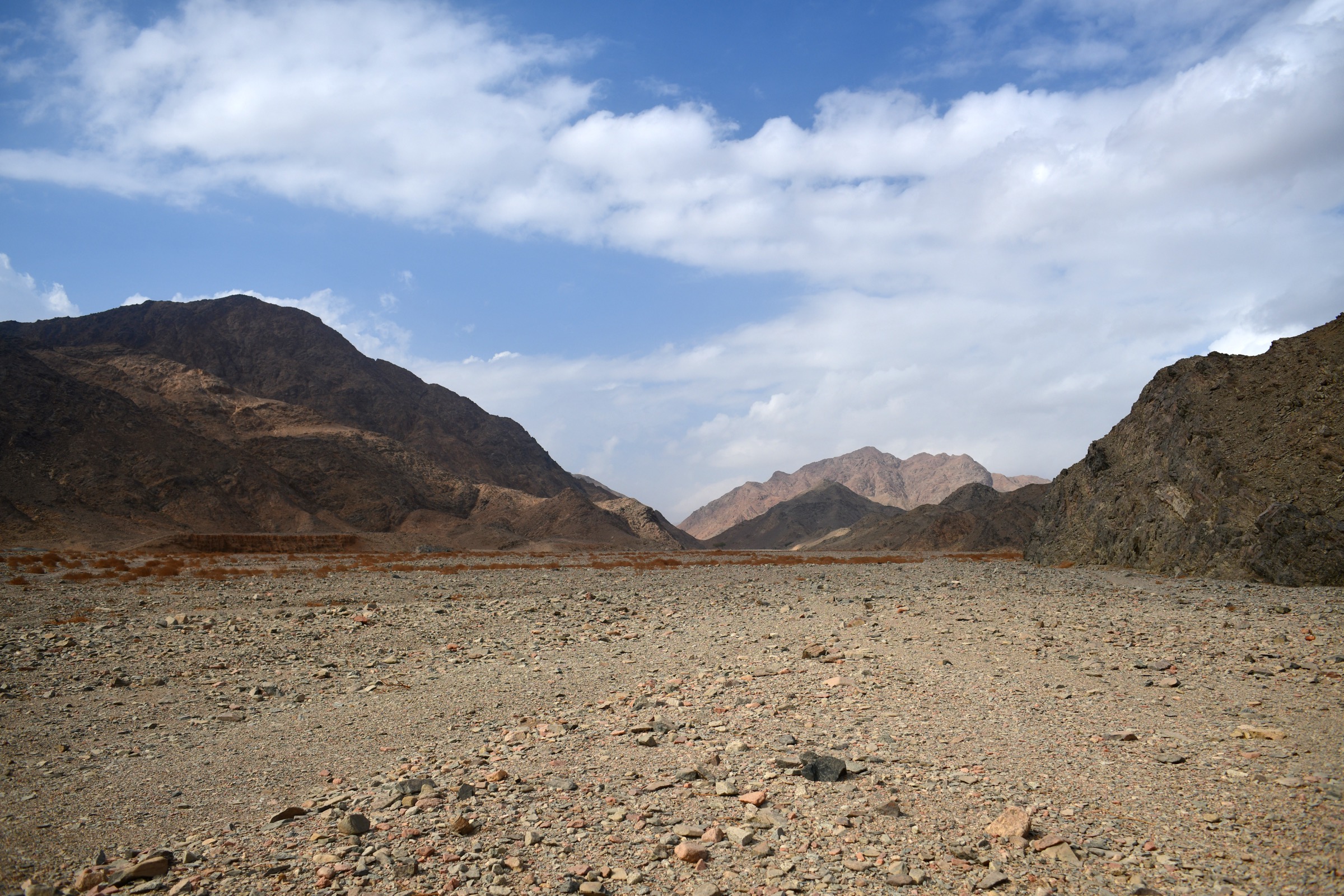
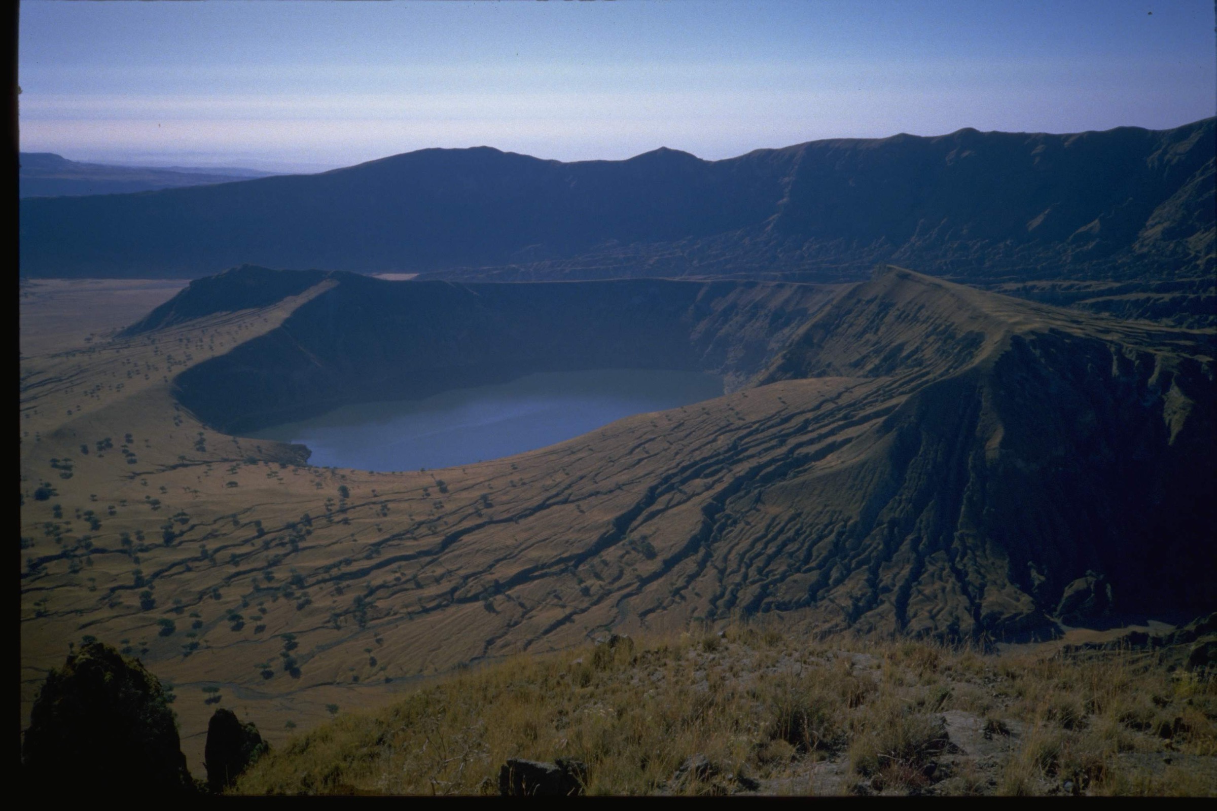
The Jebel Marra (also Marrah Mountains, Jabal Marra) is a roughly circular volcanic massif rising abruptly from the semi-arid plains of central Darfur in western Sudan. The range extends about 200 km across, straddles the boundary between Central Darfur and South Darfur states (with a small portion in North Darfur), and culminates at the rim of the Deriba Caldera, recorded variously at 3,042 m and 3,088 m above sea level. Deriba is now the highest point in Sudan following the secession of South Sudan in 2011. The massif sits on the Darfur Dome, a topographic swell that has produced basaltic shield-building, ash and pumice eruptions, and a late explosive caldera-forming event dated to about 3,520 ± 100 years before present. Hot springs and fumaroles inside the Deriba Caldera show that the volcano is dormant rather than extinct.
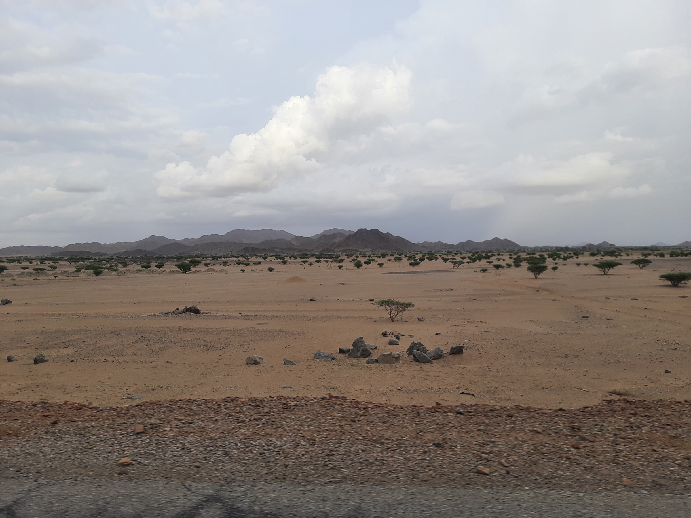
Vegetation grades sharply with altitude: thorn-scrub Sahel below about 1,000 m; cultivated terraces and gallery forest along the wadis between 1,200 and 2,000 m; a small belt of montane woodland and grassy uplands between 2,000 and 2,800 m; and bare rim cliffs and tuff above. The upper massif receives 800-1,000 mm of rainfall a year and supports permanent springs, making it the wettest mountain block in northern Sudan. Principal hiking objectives are the Deriba twin crater lakes and rim, the cliff escarpments around Suni and Quaila, the waterfalls at Niertiti, Galol/Geloul and Murtajalu on the western and southern flanks, and the gorges descending from the caldera. Recognised access villages include Deribat on the south-east, Suni on the high western flank, Nyertete (Niertiti) at the western foot, Kass and Zalingei lower down, and Kalokitting / Korongtong on the north-west side.
The dry season runs roughly November to May, with December-February the most temperate. The rainy season (June-September) brings heavy convective storms, slippery basalt and tuff, and flash floods in the wadis. Nights on the caldera rim regularly drop close to freezing in mid-winter. There are no marked trails, no functioning national park infrastructure, no rescue service, and no published official GPX route catalogue; almost every recorded ascent has used local guides and pack donkeys from the south-east approach via Deribat / Torung Tonga.
Critical safety and access note. Jebel Marra has been a frontline area of the Darfur conflicts since 2003 and remains, at the time of writing (June 2026), inaccessible to ordinary travellers. The massif is held by the Sudan Liberation Army (Abdel Wahid faction), surrounded by Rapid Support Forces (RSF) positions that restrict the flow of food, medicine and persons, and is under repeated aerial attack within the wider 2023-present Sudan war. Multiple humanitarian sources in 2026 describe Jebel Marra as a refuge for internally displaced people but effectively besieged. The U.S. State Department travel advisory for Sudan is at the highest level (Do Not Travel). No commercial trekking operates. All hike descriptions below should be read as a pre-conflict / aspirational guidebook record, not as a current travel recommendation. Every selection here is marked Candidate only on safety as well as data grounds.
Selection rationale
The five day-hikes below cover the routes most consistently named in the small pre-2003 literature on Jebel Marra. The Deriba Caldera rim circuit is the iconic summit-and-crater walk, the only candidate for an “essential” route in any pre-conflict description. The inner caldera descent to the twin lakes and hot springs is the half-day complement to the rim walk. The Suni escarpment day-walk is the classic western balcony viewpoint above the high plateau villages. The Niertiti waterfall day-walk is the most accessible western-foot waterfall hike, leaving from Niertiti town. The Murtajalu / Geloul (Galol) waterfall and forest walk is the southern wadi-and-forest day-walk noted in Sudanow as the most reliable place to see remnant monkey populations.
The fifth slot could equally have been given to a walk from Quaila or from Korongtong / Kalokitting on the north-west side; both are mentioned in volcanological literature but have weaker route documentation. Routes that are sometimes proposed (full traverse Deribat-Suni-Niertiti, multi-day Wadi Azum descent, Nyala-to-caldera caravan track) have been excluded as multi-day rather than day-hikes.
Summary table
| # | Hike | Country | Route type | Distance | Gain | Max elevation | Difficulty |
|---|---|---|---|---|---|---|---|
| 1 | Deriba Caldera rim circuit | Sudan | Loop | ~14-16 km | ~500-700 m | ~3,042-3,088 m | Strenuous |
| 2 | Twin lakes and hot springs (inner caldera) | Sudan | Out-and-back | ~6-8 km | ~150-250 m | ~2,800 m | Moderate |
| 3 | Suni (Sony) escarpment day-walk | Sudan | Out-and-back / short loop | ~10-12 km | ~400-600 m | ~2,400 m | Moderate |
| 4 | Niertiti (Nyertete) waterfall walk | Sudan | Out-and-back | ~6-8 km | ~200-300 m | ~1,400 m | Easy-Moderate |
| 5 | Murtajalu / Geloul waterfall and forest walk | Sudan | Out-and-back | ~6-10 km | ~200-400 m | ~1,800 m | Moderate |
All five hikes carry an additional security caveat — see Regional overview.
1. Deriba Caldera Rim Circuit

Snapshot
Itinerary
From the camp at the foot of the southern caldera wall the route climbs through a weakness in the rim — the south-eastern notch most often described — and gains the rim crest at about 2,900 m. The crest is followed clockwise around the basin, with the larger and shallower eastern crater lake visible most of the way and the central cone and its deeper lake increasingly prominent. The southern arc carries the highest point of the rim and of the massif, marked on Sudanese mapping at 3,042 m and on the Smithsonian Institution’s Global Volcanism Program at 3,088 m. The northern and north-western arc is the lowest section and is the line used by trekkers descending from Deriba to a wadi northward toward the Karonga / Kalokitting tracks. SummitPost describes the return either as a retracing of the canyon used on ascent or as a descent of the north slopes to join the dry riverbed that leads to the 4x4 track at Karonga.
Why it is essential
The Deriba rim is the single defining feature of the Marra massif and is described in every pre-conflict account of the mountain as the headline objective. It combines Sudan’s high point, the only significant crater lakes in the country, the freshest large caldera in north-east Africa (about 3,500 years old), and an uninterrupted aerial view of the basaltic shield-and-tuff geology that built the range.
Equipment
Mountain hiking equipment: sturdy boots with good grip on basaltic scree and pumice, full windproof and warm layers (sub-zero nights and strong wind are normal on the rim in winter), 3 L of water per person (no reliable refill on the rim), sun protection, headtorch, donkey-assisted multi-day camp support to reach and leave the trailhead, a local guide, and a satellite communicator strongly recommended.
Hazards and notes
Active conflict zone; aerial attacks and ground combat recorded as recently as 2026. The route is not currently accessible to ordinary travellers. Travel permits historically required from Khartoum, with photocopies presented at multiple checkpoints en route. Exposure to long drops into the caldera on the inner side of the rim crest, particularly on the south-eastern arc. Faint or absent path; navigation is by terrain. Lightning risk on the rim in any wet-season storm. No mountain rescue.
GPX / KML links
| Source | URL | Format / access | Reuse status |
|---|---|---|---|
| OpenStreetMap (no curated trail relation) | openstreetmap.org near Deriba | OSM data (ODbL) | Geometry of village positions and major tracks usable; no curated route |
| Smithsonian Global Volcanism Program — Jebel Marra | volcano.si.edu | Web only | Summit pinpoint only; public domain (US govt) |
| Route-file status | No published GPX located in this pass | Unresolved | Unresolved |
Approximate centre of the caldera: 12°57′N 24°16′E.
External links
- UNESCO World Heritage Centre — Jebel Marra / Deriba Caldera (tentative list)
- Smithsonian Global Volcanism Program — Jebel Marra
- Wikipedia — Marrah Mountains
- SummitPost — Jebel Marra
2. Twin Lakes and Hot Springs (Inner Caldera)

Snapshot
Itinerary
From the caldera-floor camp the route skirts the southern shore of the large shallow eastern lake, which is about 2.5 km long, then turns toward the central cone — a young pumice-and-tuff cone roughly in the middle of the basin. A short scramble up the cone gives a direct view down onto the smaller but very deep crater lake (about 108 m deep) cradled in its summit crater. The descent loops back along the western shore of the eastern lake past a cluster of hot springs and fumaroles, first described scientifically by Francis and Thorpe in 1972, before returning to camp.
Why it is essential
The interior of the Deriba Caldera is the only place in Sudan where two active crater lakes, a 108 m-deep volcanic vent lake, and live hot-spring and fumarole activity are gathered into a single short walk. For visitors who do not have the time or weather window for the full rim circuit, the inner walk delivers the essential geology of the volcano with limited exposure.
Equipment
Mountain hiking equipment: sturdy boots (the ash surface is loose and abrasive), warm layers (temperature inversions and cold floor air are common), 2 L of water (the lake water is alkaline and the spring water hot — do not drink either), headtorch and small first-aid kit.
Hazards and notes
Same security context as Hike 1. Fumarole gases (mainly steam and CO₂) accumulate in still air pockets near the springs; keep moving and stay on the breeze side. Lake margins are soft and unstable in places; do not walk out on the shallow eastern lake bed. Sudden weather changes; thunderstorms can fill the caldera with cloud in minutes.
GPX / KML links
| Source | URL | Format / access | Reuse status |
|---|---|---|---|
| OpenStreetMap (caldera-lake outlines only) | openstreetmap.org near Deriba | OSM data (ODbL) | Geometry partial; no curated walking relation |
| Route-file status | No published GPX located in this pass | Unresolved | Unresolved |
External links
- Wikipedia — Deriba (caldera)
- NASA Earth Observatory — Deriba Caldera, Sudan
- Francis & Thorpe (1972), Nature — Hot Springs and Fumaroles at Jebel Marra
3. Suni (Sony) Escarpment Day-Walk
Snapshot
Itinerary
Suni sits on the high western plateau of Jebel Marra and is historically the location of a “rest-house” mentioned by the Sudanese tourism authority as the upper waypoint for visitors to the massif. From the village the route climbs through irrigated orange and onion terraces — a signature of the Fur agricultural system on the upper slopes — into thinning scrub and onto basalt benches at the rim of the great western escarpment that drops 1,500 m toward Wadi Azum and the plains beyond. Several viewpoints look back east toward the dome of the Deriba massif and west onto Niertiti and the Sahel. Descent retraces the climb or, in some local itineraries, loops south through neighbouring hamlets before rejoining the main track to the rest-house.
Why it is essential
Suni is the classic balcony of Jebel Marra: the only easily reached point on the high massif from which both the cultivated upper Fur landscape and the abrupt western escarpment can be seen in a single short day. It is mentioned by name in Sudanow Magazine’s standard tourism profile as one of the principal attractions, and is consistently described as the standard overnight stop on the western side of the mountain.
Equipment
Standard hiking equipment: sturdy walking shoes for rocky basalt paths and irrigation channels, sun protection for the open upper terraces, 2 L of water, and a light warm layer (the plateau is cool even in the dry season).
Hazards and notes
Same security context as Hike 1; Suni has repeatedly featured in conflict-displacement reports. Cultivated land is in active use; routes pass close to private terraces and irrigation works — a local guide is essential. Cliff-edge exposure on the escarpment. No drinking water apart from village wells; treat all sources.
GPX / KML links
| Source | URL | Format / access | Reuse status |
|---|---|---|---|
| OpenStreetMap (village positions only) | openstreetmap.org near Suni | OSM data (ODbL) | Geometry partial |
| Route-file status | No published GPX located in this pass | Unresolved | Unresolved |
External links
4. Niertiti (Nyertete) Waterfall Walk
Snapshot
Itinerary
From Niertiti town the path leads east up the wadi that drains the western shoulder of Jebel Marra, passing irrigated mango and citrus gardens that exploit the permanent flow from the high massif. After about an hour the wadi narrows into a short basaltic gorge with the named Niertiti waterfall — a vertical drop of several tens of metres in the wet season — and a pool at its base. The standard short walk turns at the pool and retraces the wadi to town; the longer variant continues up a steep scrambling line beside the falls to a viewpoint on the lower escarpment.
Why it is essential
The Niertiti waterfall is the western-foot waterfall most often named in Sudanese tourism material and in the UNESCO tentative listing as a characteristic attraction of the massif. It is the most accessible introductory walk on Jebel Marra in normal times: a half-day excursion from a sizeable town with no high-altitude requirement, suitable as the only walk for visitors with limited time.
Equipment
Standard hiking equipment: trail shoes with grip (the gorge floor is wet and slippery near the falls), sun protection on the open wadi sections, 2 L of water, and swimwear optional for the lower pool (check local custom with the guide).
Hazards and notes
Same security context as Hike 1; Niertiti town has been repeatedly attacked during the 2023-present war and is currently not accessible. Flash floods in the wadi during and immediately after wet-season storms; abandon the gorge at the first sign of cloud build-up on the high massif. The pool is not lifeguarded; depth and underwater debris are unknown. All drinking water needs treatment.
GPX / KML links
| Source | URL | Format / access | Reuse status |
|---|---|---|---|
| OpenStreetMap (Niertiti town mapped; no curated trail) | openstreetmap.org near Niertiti | OSM data (ODbL) | Geometry partial |
| Route-file status | No published GPX located in this pass | Unresolved | Unresolved |
External links
- UNESCO World Heritage Centre — Jebel Marra / Deriba Caldera (tentative list)
- Sudanow Magazine — Jebel Marra tourism profile
5. Murtajalu / Geloul (Galol) Waterfall and Forest Walk
Snapshot
Itinerary
The route enters a thick gallery forest along one of the southern wadis draining off Jebel Marra. Sudanow Magazine describes the Murtajalu area as carrying “an attractive waterfall” with “many species of monkeys, other wild animals and birds”, and the Geloul (Galol) area immediately adjacent as “thick forests and constant cataracts” with rare and tame wildlife. The standard walk follows the wadi up through the forest to one of these named cascades and returns the same way; some local itineraries continue further up the catchment to a higher viewpoint above the forest canopy.
Why it is essential
This is the southern-flank counterpart to the Niertiti walk and the only Jebel Marra day-hike that is consistently described in Sudanese tourism literature as a wildlife-focused experience, rather than a geology or viewpoint walk. It complements the headline Deriba and Suni objectives and is the only short walk in the suggested catalogue that gives the typical Marra forest landscape — patches of evergreen broadleaf woodland watered by permanent springs in a Sahelian setting.
Equipment
Standard hiking equipment: boots with grip on damp forest floor and stream crossings, insect protection (some mosquitoes and biting flies year-round near water), 2 L of water (treat all sources), quiet behaviour for wildlife observation, and binoculars.
Hazards and notes
Same security context as Hike 1. Flash-flood risk in the wadi in any wet-season storm. The forest canopy makes navigation by sight difficult; a guide is essential. Wildlife is largely shy outside the named “tame animal” pockets; do not approach primates or attempt to feed them.
GPX / KML links
| Source | URL | Format / access | Reuse status |
|---|---|---|---|
| OpenStreetMap (southern wadi network poorly mapped) | openstreetmap.org south Jebel Marra | OSM data (ODbL) | Geometry partial |
| Route-file status | No published GPX located in this pass | Unresolved | Unresolved |
External links
Missing data / follow-up work
- The entire entry is marked Candidate only because Jebel Marra has been an active conflict zone since 2003 and is, in mid-2026, effectively besieged. None of the hikes can currently be walked by ordinary travellers, and the safety landscape changes month to month.
- No official park GPX, KML or trail map has ever been published for Jebel Marra. All distance, ascent and elevation figures for hikes 1, 3, 4 and 5 are approximations derived from textual sources, satellite imagery and topographic inference; none has been ground-verified.
- Sources disagree on the summit elevation: 3,042 m (UNESCO tentative list; Wikipedia); 3,088 m (Smithsonian Global Volcanism Program); 3,012 m (some popular sources). The first two are derived from independent surveys and both should be treated as approximate until a modern survey is published.
- Place-name transliteration varies widely: Suni / Sony / Suney; Niertiti / Nyertete / Nertete; Galol / Geloul; Karonga / Korongtong / Kalokitting; Deribat / Dhareebah / Torung Tonga. Future passes should reconcile these against the 1961 Sudan survey sheets.
- The Wikimedia Commons “WH2B Jebel Marra Deriba Caldera” campaign category reportedly contains around 77 files; individual files, their dimensions and their licences were not enumerated and should be reviewed for cover-photo candidates ≥2,400 px long edge.
- The single NASA ISS oblique photograph used as Hike 1’s cover candidate is public domain but its exact pixel dimensions on Commons were not confirmed; the original NASA frame ISS018-E-6051 should be retrieved directly from the Earth Observatory image database for the highest-resolution copy.
- No GPX, KML or open route file was located for any of the five hikes on Wikiloc, AllTrails, Komoot, Outdooractive, OpenStreetMap relations, or any official Sudanese source.
- The Murtajalu / Geloul (Galol) walk is described only in tourism-press level material; whether these are separate features in two adjacent wadis, or two names for the same site, needs confirmation from a local source.
- Public-transport information is historical only; in 2026, virtually no scheduled transport runs in Darfur.
- Hot-spring temperatures and gas compositions cited by Francis & Thorpe (1972) are now over fifty years old; modern monitoring data appear to be absent.
- Cultural and customary access rules (sacred groves, fees collected by local communities) are not documented in the open literature and would need to be confirmed on the ground.
External links
| Resource | Link |
|---|---|
| UNESCO World Heritage Centre — Jebel Marra / Deriba Caldera (tentative list 6519) | whc.unesco.org |
| Smithsonian Global Volcanism Program — Jebel Marra | volcano.si.edu |
| Wikipedia — Marrah Mountains | en.wikipedia.org |
| Wikipedia — Deriba (caldera) | en.wikipedia.org |
| Wikipedia — Darfur Dome | en.wikipedia.org |
| SummitPost — Jebel Marra | summitpost.org |
| NASA Earth Observatory — Mt. Marra, Sudan | science.nasa.gov |
| NASA Earth Observatory — Deriba Caldera, Sudan | science.nasa.gov |
| Sudanow Magazine — Jebel Marra tourism profile | sudanow-magazine.net |
| Volcano Hotspot — Jebel Marra and the Deriba Caldera (2024) | volcanohotspot.wordpress.com |
| U.S. Department of State — Sudan Travel Advisory | travel.state.gov |
| Wikimedia Commons — Category:Marrah Mountains | commons.wikimedia.org |