Regional overview
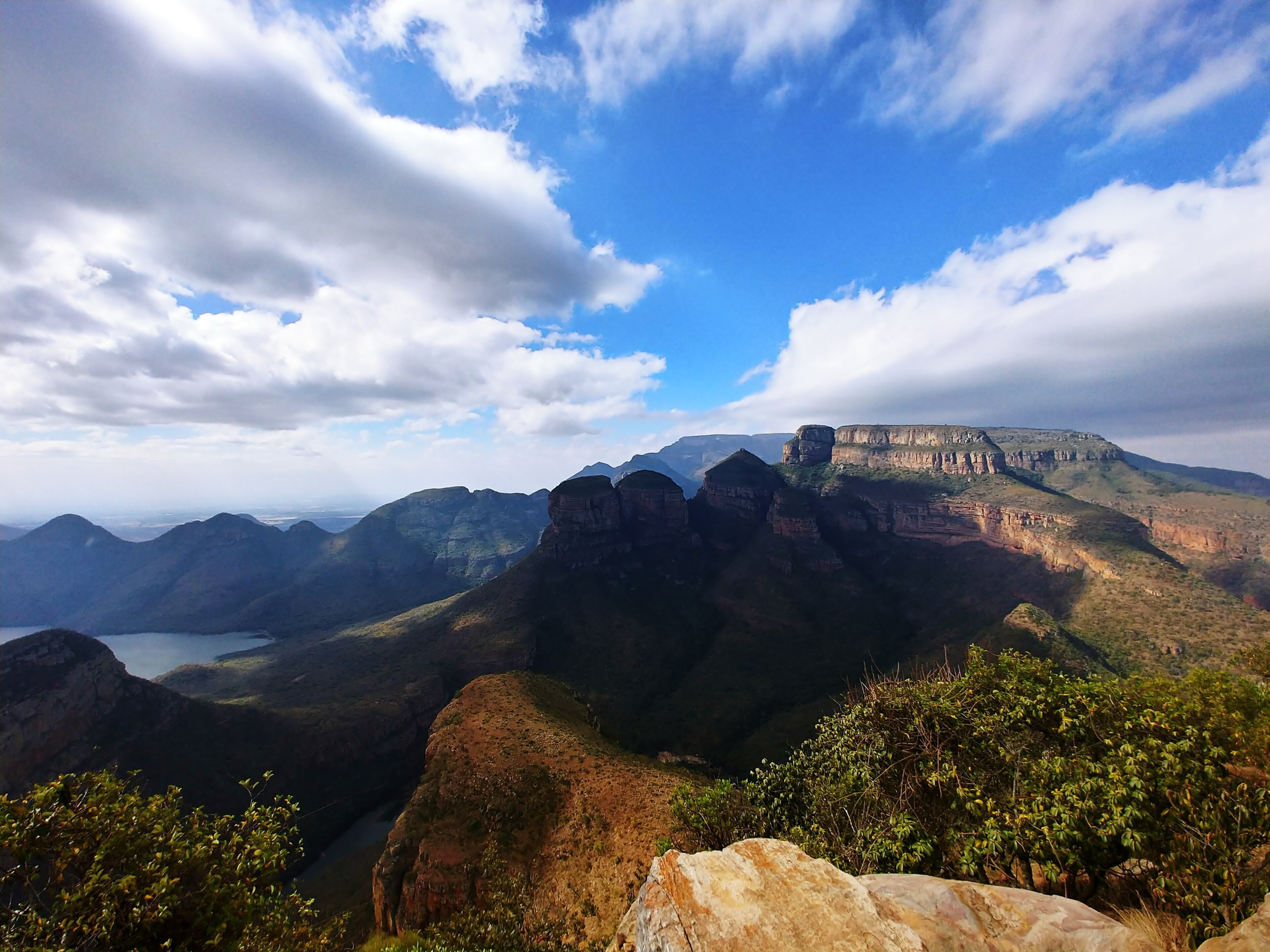
The Mpumalanga Escarpment is the Panorama Route sector of the Great Escarpment around Graskop, Sabie, God’s Window, Bourke’s Luck Potholes, Blyde River Canyon and the Mac Mac forest belt. Walking here is typically short to medium length, with high scenic return: canyon-rim viewpoints, subtropical forest, tufa waterfalls, pothole geology, quartzite outcrops, river gorges and timber-plantation forest trails.
This is not a single continuous national-park trail system. Routes are split between Mpumalanga Tourism and Parks Agency sites, Blyde River Canyon / Forever Resort trailheads, SAFCOL forestry areas, private concessions and commercial visitor sites. Heavy rain can close viewpoints, bridges and waterfall trails at short notice. In January 2026 several Panorama Route sites were temporarily closed after heavy rain; regional reporting later said MTPA-managed attractions reopened, but forestry-site status must still be checked directly before travel.
Selection rationale
The five selected hikes cover the essential walking themes of the Mpumalanga Escarpment: a Blyde Canyon / Three Rondavels trail, a World’s End rim loop, the iconic God’s Window rainforest steps, a true day-walk from Bourke’s Luck Potholes, and a Mac Mac forest waterfall route near Sabie. Lisbon Falls and Graskop Gorge were kept as regional context rather than selected hikes because the better-verified walking routes give more substantial day-hike value than a short viewpoint stop or lift-assisted boardwalk.
- Tufa, Guinea Fowl and Leopard Trail — the Blyde Canyon resort trail family combined into a 7.1 km loop.
- World’s End Viewpoint Loop via Lower Viewpoint — a 6.3 km canyon-rim loop above the Blyde River.
- Rainforest Trail via God’s Window — the iconic God’s Window stepped rainforest viewpoint walk.
- Belvedere Day Walk from Bourke’s Luck Potholes — a 10 km gorge-side day from the famous pothole site.
- Forest Falls Trail — a Sabie / Mac Mac forest waterfall route.
Summary table
| # | Hike | Route type | Distance | Gain | Max elevation | Difficulty |
|---|---|---|---|---|---|---|
| 1 | Tufa, Guinea Fowl and Leopard Trail | Loop | 7.1 km | 358 m | 1219 m | Moderate |
| 2 | World’s End Viewpoint Loop via Lower Viewpoint | Loop | 6.3 km | 315 m | 1219 m | Moderate |
| 3 | Rainforest Trail via God’s Window | Out-and-back | 2.4 km | 138 m | 1709 m | Moderate |
| 4 | Belvedere Day Walk from Bourke’s Luck Potholes | Loop / out-and-back circuit candidate | 10.0 km | Moderate | ||
| 5 | Forest Falls Trail | Official source says circular; AllTrails maps out-and-back | 4.5-4.7 km | 86 m on AllTrails mapped version | 1258 m | Moderate |
1. Tufa, Guinea Fowl and Leopard Trail
Snapshot
Itinerary
This route combines the Blyde Canyon resort trail family: Kadishi / Tufa, Guinea Fowl and Leopard. KLCBT describes the Kadishi-Tufa Trail as a 2 km trail along the Kadishi River with a tufa waterfall, the Guinea Fowl Trail as a 3 km trail descending into the Kadishi River valley, and the Leopard Trail as a 5 km trail with views over the northern Blyde River Canyon, Blyde Dam, Three Rondavels and Mariepskop. AllTrails maps a 7.1 km loop that links the Guinea Fowl and Leopard trail markings with swimming holes, river crossings, forested sections and canyon viewpoints.
The practical walking day should start with the map issued at the entrance, then follow the marked resort trails rather than trying to improvise a canyon shortcut.
Why it is essential
This is the best compact walking expression of the Blyde Canyon / Three Rondavels landscape: canyon views, river vegetation, tufa waterfall and steep escarpment terrain in one loop. It is more hike-like than simply driving to the Three Rondavels viewpoint.
Hazards and notes
Expect rocky sections, slippery river margins after rain, possible river crossings, steep singletrack near viewpoints and heat/humidity. Pay the entrance fee, carry the provided trail map and obey local closure notices after heavy rain.
GPX / KML links
| Source | URL | Format / access | Reuse status |
|---|---|---|---|
| AllTrails: Tufa, Guinea Fowl and Leopard Trail | alltrails.com | Source map | AllTrails terms apply; direct GPX not retrieved; source-map reference only, route statistics verified through AllTrails |
| KLCBT: Guinea Fowl Trail | klcbt.co.za | Official/local descriptive trail page | KLCBT page terms not stated for route geometry; context and component trail description only |
| KLCBT: Kadishi-Tufa Trail | klcbt.co.za | Official/local descriptive trail page | KLCBT page terms not stated for route geometry; context and component trail description only |
| KLCBT: Leopard Trail | klcbt.co.za | Official/local descriptive trail page | KLCBT page terms not stated for route geometry; context and component trail description only |
External links
- AllTrails — Tufa, Guinea Fowl and Leopard Trail
- KLCBT — Guinea Fowl Trail
- KLCBT — Kadishi-Tufa Trail
- KLCBT — Leopard Trail
2. World’s End Viewpoint Loop via Lower Viewpoint
Snapshot
Itinerary
The route links the World’s End / Upper Viewpoint area with a lower viewpoint loop above the Blyde River Canyon. AllTrails records it as a 6.3 km moderate loop near Blyde River Canyon Nature Reserve, with river, waterfall and viewpoint features. SA-Venues describes Blyde Canyon A Forever Resort as giving direct access to the Three Rondavels, the Blyde Canyon Gorge and World’s End, and notes five hiking trails in the resort area.
Use the local resort or reserve map at the gate and stay on marked trail lines. The canyon rim has many nearby viewpoints, roads and accommodation tracks, so a downloaded offline map alone should not replace local signage.
Why it is essential
World’s End is one of the classic Blyde Canyon rim viewpoints. A loop via the lower viewpoint turns the famous panorama into a real walk, with changes in angle, elevation and vegetation rather than a single roadside stop.
Hazards and notes
Edges, wet rock, steep drops, mist, lightning and poor visibility are the main concerns. Access conditions can differ for resort guests and day visitors; confirm gate rules and fees before relying on this route.
GPX / KML links
| Source | URL | Format / access | Reuse status |
|---|---|---|---|
| AllTrails: World’s End Viewpoint Loop via Lower Viewpoint | alltrails.com | Source map | AllTrails terms apply; direct GPX not retrieved; source-map reference only, route statistics verified through AllTrails |
| Blyde Canyon A Forever Resort listing | sa-venues.com | Descriptive access context | SA-Venues terms; no route file; context only, no GPX/KML found |
External links
- AllTrails — World’s End Viewpoint Loop via Lower Viewpoint
- SA-Venues — Blyde Canyon A Forever Resort
3. Rainforest Trail via God’s Window
Snapshot
Itinerary
From the God’s Window visitor area, follow the stepped footpath up through the indigenous rainforest to the viewpoints on the escarpment. KLCBT describes God’s Window as one of Mpumalanga’s iconic viewpoints and notes the rainforest walk through indigenous forest. South African History Online similarly describes a steep stepped footpath from the parking area to viewpoints on the escarpment edge. AllTrails maps the Rainforest Trail via God’s Window as a 2.4 km out-and-back with 138 m ascent and a maximum elevation of about 1709 m.
In January 2026 MTPA temporarily closed God’s Window after heavy rain; later regional reporting said the MTPA-managed Panorama Route sites reopened. Because this is a managed attraction, same-day opening status should still be checked before publication or travel.
Why it is essential
God’s Window is the iconic high viewpoint of the southern Panorama Route. The rainforest steps make it a short hike rather than just a lookout, and the route captures the mistbelt vegetation that distinguishes this part of the escarpment from the drier canyon rim.
Hazards and notes
Steps can be slippery in mist or rain. Visibility can be poor when cloud sits on the escarpment. Stay behind viewpoint barriers and respect any closure signs after heavy rainfall.
GPX / KML links
| Source | URL | Format / access | Reuse status |
|---|---|---|---|
| AllTrails: Rainforest Trail via God’s Window | alltrails.com | Source map | AllTrails terms apply; direct GPX not retrieved; source-map reference only, route statistics verified through AllTrails |
| KLCBT: God’s Window | members.krugerlowveld.co.za | Local tourism description | KLCBT / member-site terms; no route file; context only, no GPX/KML found |
| MTPA temporary closure notice | mpumalanga.com | Official closure notice | Not a route file; access-status source, later reopening reporting also required |
| Lowvelder reopening report | citizen.co.za | News access-status report | Not a route file; reopening context only |
External links
- AllTrails — Rainforest Trail via God’s Window
- KLCBT / Kruger Lowveld — God’s Window
- South African History Online — God’s Window
- MTPA — Temporary closure notice, 13 January 2026
- Lowvelder — Panorama Route attractions open again, 21 January 2026
4. Belvedere Day Walk from Bourke’s Luck Potholes
Snapshot
Itinerary
The Belvedere day hike is the one-day option associated with the Blyderivierspoort Hiking Trail system. Mpumalanga Tourism and Parks Agency’s “Ready to Ramble” article describes a 10 km circular trail from Bourke’s Luck Potholes to the Belvedere hydro power plant and back. It states that permits are bought at Bourke’s Luck Potholes and that the walk can take about five hours, with a recommendation to start before noon.
This route gives a fuller walking day than the short pedestrian bridges at Bourke’s Luck Potholes, while still using the region’s most important geological site as the trailhead.
Why it is essential
Bourke’s Luck Potholes is one of the defining natural features of the Mpumalanga Escarpment, where the Treur and Blyde rivers have carved cylindrical potholes into the bedrock. The Belvedere day walk extends the visit into a real gorge-side hike and avoids selecting the 1.1 km tourist loop as the only Bourke’s Luck walking entry.
Hazards and notes
High water, slippery rock, exposed sun, heat and remote sections away from the busy visitor bridges are key hazards. MTPA temporarily closed Bourke’s Luck Potholes in January 2026 after heavy rain; later regional reporting said the managed sites reopened. Check current site access, permit rules and start-time limits before travel.
GPX / KML links
| Source | URL | Format / access | Reuse status |
|---|---|---|---|
| MTPA: Ready to Ramble, Belvedere day hike description | mpumalanga.com | Descriptive route source | MTPA site terms; no downloadable route file found; route description only, no GPX/KML found |
| AllTrails: Bourke’s Luck Potholes short loop | alltrails.com | Nearby short source map, not the Belvedere route | AllTrails terms apply; direct GPX not retrieved; context only, not a substitute for Belvedere geometry |
| OpenStreetMap search | openstreetmap.org | Map search | OSM data is ODbL; geometry cross-check target only, no route relation selected |
External links
- MTPA — Ready to Ramble
- KLCBT — Bourke’s Luck Potholes
- AllTrails — Bourke’s Luck Potholes
- MTPA — Temporary closure notice, 13 January 2026
- Lowvelder — Panorama Route attractions open again, 21 January 2026
5. Forest Falls Trail
Snapshot
Itinerary
KLCBT describes Forest Falls Trail as a 4.5 km circular route beginning and ending at the Green Heritage Picnic Site, opposite Maria Shires Falls on the R532 towards Graskop. The walk passes through the forests around Sabie and leads to Forest Falls, described locally as the only waterfall in the area wider than it is high. A permit is required and KLCBT states it can be obtained from the Forestry Museum in Sabie. AllTrails maps a 4.7 km Forest Falls route near Pilgrim’s Rest, following the Mac Mac River to the waterfall, with 86 m of gain.
Because the official/local description and AllTrails geometry differ, the local permit office or SAFCOL should be treated as the controlling source for the current route line.
Why it is essential
The Mac Mac / Sabie forest belt is the forest-and-waterfall counterpart to the open Blyde Canyon rim. Forest Falls adds indigenous-forest walking, river sound and waterfall terrain to a selection otherwise dominated by canyon viewpoints.
Hazards and notes
The trail can be slippery after rain, and AllTrails reviews flag overgrown or tricky sections. January 2026 regional reporting said SAFCOL closed Forest Falls and other waterfall sites as a precaution after heavy rain; no later reopening notice was verified in this pass. Check with SAFCOL, the Forestry Museum in Sabie, or local tourism before relying on access.
GPX / KML links
| Source | URL | Format / access | Reuse status |
|---|---|---|---|
| KLCBT: Forest Falls Trail | klcbt.co.za | Official/local descriptive trail page | KLCBT page terms not stated for route geometry; route description only, no GPX/KML found |
| AllTrails: Forest Falls | alltrails.com | Source map | AllTrails terms apply; direct GPX not retrieved; secondary mapped route, statistics verified through AllTrails |
| Wikiloc: Forest Falls Day Trail | wikiloc.com | Source map / GPX availability via Wikiloc | Wikiloc terms apply; account may be required; direct command-line retrieval was blocked by Cloudflare; candidate route-file source, GPX not downloaded in this pass |
External links
- KLCBT — Forest Falls Trail
- AllTrails — Forest Falls
- Wikiloc — Forest Falls Day Trail
- Getaway — January 2026 rainfall closure report mentioning Forest Falls
External links
| Source | URL |
|---|---|
| AllTrails — Tufa, Guinea Fowl and Leopard Trail | alltrails.com |
| AllTrails — World’s End Viewpoint Loop via Lower Viewpoint | alltrails.com |
| AllTrails — Rainforest Trail via God’s Window | alltrails.com |
| AllTrails — Bourke’s Luck Potholes | alltrails.com |
| AllTrails — Forest Falls | alltrails.com |
| KLCBT — Guinea Fowl Trail | klcbt.co.za |
| KLCBT — Kadishi-Tufa Trail | klcbt.co.za |
| KLCBT — Leopard Trail | klcbt.co.za |
| KLCBT — God’s Window | members.krugerlowveld.co.za |
| KLCBT — Bourke’s Luck Potholes | klcbt.co.za |
| KLCBT — Forest Falls Trail | klcbt.co.za |
| MTPA — Ready to Ramble | mpumalanga.com |
| MTPA — Temporary closure notice, 13 January 2026 | mpumalanga.com |
| Lowvelder — Panorama Route attractions open again, 21 January 2026 | citizen.co.za |
| Getaway — All MTPA-managed sites open to visitors, 22 January 2026 | getaway.co.za |
| SA-Venues — Blyde Canyon A Forever Resort | sa-venues.com |
| South African History Online — God’s Window | sahistory.org.za |