Regional overview
The Tsitsikamma Mountains form the forested, ocean-facing eastern end of the Cape Fold Belt, where quartzite ridges, indigenous forest, tannin-dark rivers and steep coastal ravines meet the Indian Ocean. For day walkers, the best base areas are:
- Storms River Mouth Rest Camp for the Mouth Trail, suspension bridge, Waterfall Trail, Loerie and Blue Duiker forest trails.
- Storms River / Plaatbos / Big Tree for accessible old-growth forest walks.
- Nature’s Valley / De Vasselot for river-mouth and forest trails, subject to closures and flood damage.
The walking character is not high-alpine, but it is still serious in places: wet boardwalks, steep wooden stairs, forest roots, slippery rock, boulder-hopping shoreline, sudden weather, wave exposure and tide-sensitive coastal sections.
As of this check, SANParks says the main 77 m Storms River Mouth suspension bridge is closed from 24 March to 23 June 2026 for reconstruction, although the suspension-bridge trail itself remains partly accessible and visitors must follow posted safety signage.
Selection rationale
The selection keeps the Storms River / Otter / forest / Nature’s Valley balance, with the following emphasis:
- Use the official Mouth Trail as the headline walk, with the lookout loop as an optional extension.
- Treat the Waterfall Trail as a day section of the Otter Trail, not as “Otter Trail Day 1” in full.
- Use the official Blue Duiker Trail rather than over-weighting app variants.
- Keep Salt River Mouth as a conditional Nature’s Valley choice, because access has been unstable and the official Salt River via Keurpad route is listed closed.
- Treat Big Tree as the full Ratel Trail options, so it functions as a proper forest walk rather than just a 10-minute boardwalk stop.
Summary table
| # | Hike | Base area | Route type | Distance | Elevation gain/loss | Max elevation | Difficulty |
|---|---|---|---|---|---|---|---|
| 1 | Storms River Mouth Trail and Lookout Loop | Storms River Mouth | Official out-and-back; optional loop/extension | 2.0 km official; c. 3.7 km tracked loop | Official not published; third-party loop c. +221 m / -221 m | c. 178 m on tracked loop | Easy to moderate |
| 2 | Waterfall Trail / Otter Trail day section | Storms River Mouth | Out-and-back | 6.0 km official return | Official not published; third-party tracks vary, c. +130–180 m | c. 50–60 m near coastal bluffs | Moderate to strenuous |
| 3 | Blue Duiker Forest Trail | Storms River Mouth | Circular / forest circuit | 3.7 km official | Third-party track c. +144 m / -155 m | c. 133 m on tracked route | Moderate |
| 4 | Salt River Mouth Trail | Nature’s Valley / De Vasselot | Loop or out-and-back variants | c. 3.7–5.2 km common loop; official Salt River via Keurpad route 15.1 km and closed | Third-party loop c. +192 m / -192 m | c. 113 m on tracked loop | Moderate |
| 5 | Ratel Trail and Tsitsikamma Big Tree | Big Tree / Plaatbos | Loop options | 1.0 km green, 2.6 km yellow, 4.2 km red official options | Third-party yellow-route track c. +78 m / -78 m | c. 302 m on tracked route | Easy |
Before you go
Required equipment
Storms River Mouth / Blue Duiker / Big Tree
- Comfortable walking or hiking shoes with good grip.
- Light rain shell; forest and sea mist can make surfaces wet.
- Water, sun protection and a warm layer.
- Phone or GPS app useful, but do not rely on signal.
Waterfall Trail / Salt River Mouth
- Hiking shoes with excellent grip.
- Tide table and swell/weather check.
- Enough water and snacks for a slower-than-expected return.
- Rain shell, sun protection and small first-aid kit.
- Dry bag or waterproof pouch for phone/camera.
No technical climbing or via ferrata equipment is required for the selected routes.
Current access and safety notes
- Storms River Mouth bridge: main bridge closure scheduled until 23 June 2026; check before publication.
- Communications: SANParks reported communication disruption in the Tsitsikamma area after a recent storm on 28 May 2026.
- Salt River / Keurpad: official Salt River via Keurpad route is listed closed due to recent floods; the short Salt River Mouth loop should be treated as conditional until current local confirmation.
- Fees: SANParks daily conservation fees apply, and Plaatbos / Goesa / Big Tree fees are specifically noted from 1 April 2026.
1. Storms River Mouth Trail and Lookout Loop
Snapshot
Itinerary
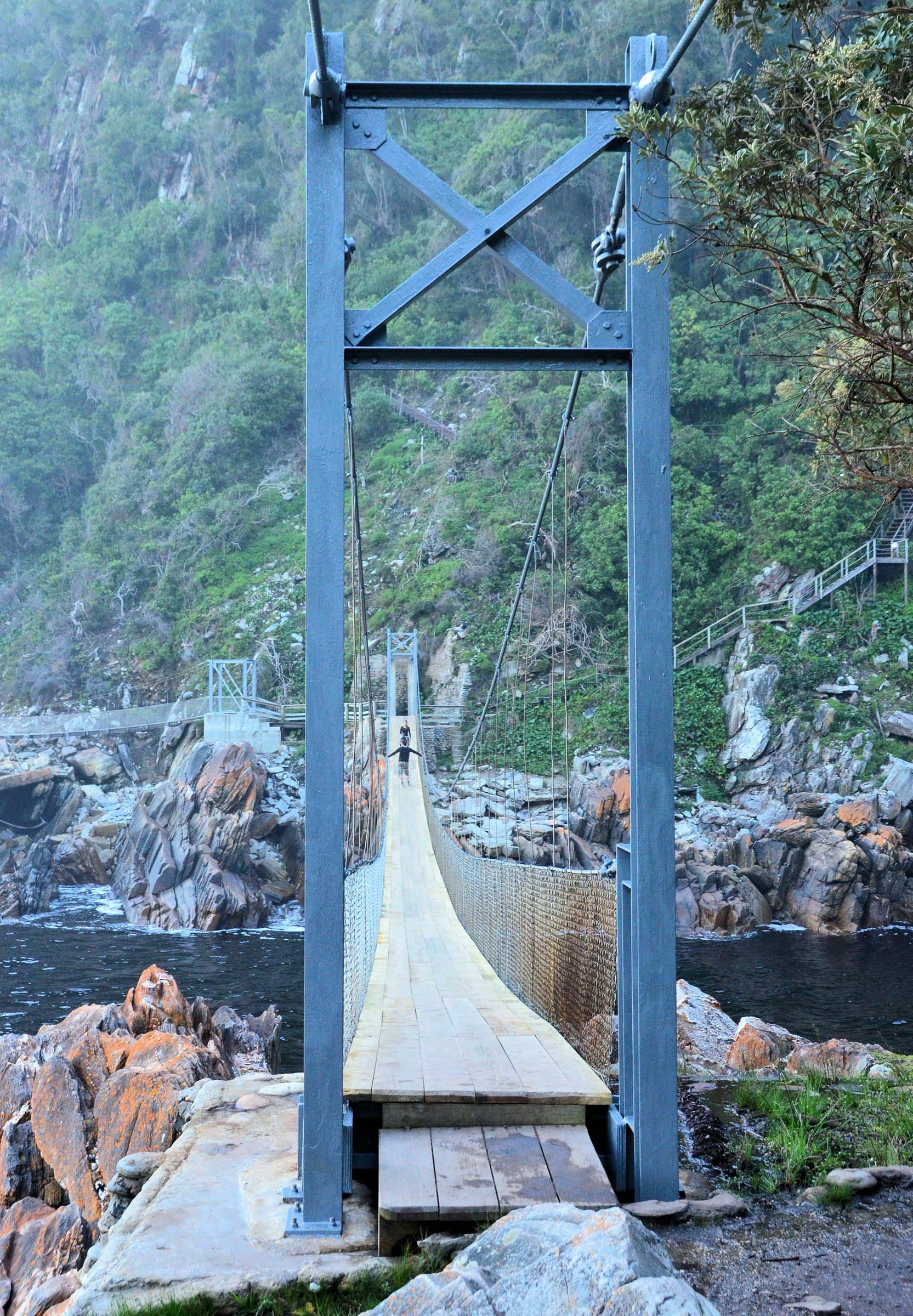
Start at Sandy Bay near the restaurant and follow the signed boardwalk eastwards through coastal forest above the Storms River estuary. The official route reaches the Storms River Mouth Cave / Khoisan heritage site, the jetty area and the suspension-bridge zone, then returns the same way.
When open, stronger walkers can continue beyond the bridge area to the plateau lookout before descending back towards the rest camp. This makes the walk feel less like a short boardwalk visit and more like a compact coastal-forest hike, with steeper steps and rougher ground near the viewpoint.
Why it is essential
This is the signature short walk of Tsitsikamma: indigenous forest, black-water gorge, sea cliffs, historic cave, suspension bridge and lookout scenery in a compact route.
Hazards and notes
- The main suspension bridge is under phased reconstruction until 23 June 2026; do not promise full bridge access without a fresh check.
- Boardwalks and stairs can be slippery after rain or sea mist.
- The lookout extension is rougher than the bridge boardwalk and adds meaningful ascent.
GPX / KML links
| Source | URL | Format / access | Reuse status |
|---|---|---|---|
| Wikiloc: Mouth Trail, Storms River Mouth Rest Camp | wikiloc.com | Download link shown on page; account may be required | Good candidate for personal verification; do not republish track without checking terms |
| Outdooractive: Storms River Mouth Trail | outdooractive.com | Route page; GPX/KML access may require account/premium | Good candidate for route confirmation |
External links
- SANParks — Storms River Mouth Rest Camp
- Wikiloc — Mouth Trail, Storms River Mouth Rest Camp
- Outdooractive — Storms River Mouth Trail
2. Waterfall Trail / Otter Trail day section
Snapshot
Itinerary
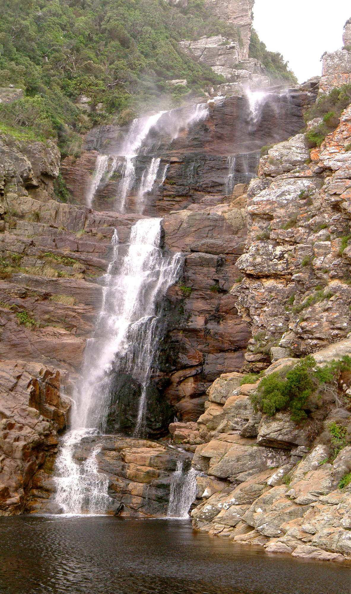
From Storms River Mouth, follow the first section of the Otter Trail west along the coast. The path alternates between forest margin, rock shelf, boulder beach and short climbs above the sea. After about 3 km the route reaches the waterfall and plunge pool where the stream drops directly onto the rocky shore.
Return by the same line. The distance looks modest, but the surface is slow: slick rock, boulder-hopping and tide timing matter more than raw kilometres.
Why it is essential
This is the best legal day-hike taste of the Otter Trail coastline: wild shore, forested cliffs, waterfall and wave-swept rock without the five-day hut booking.
Hazards and notes
- Do not start late; the route is slower than its distance suggests.
- High tide and swell can make the shore sections dangerous.
- Wet rock is the main accident risk.
- Carry enough water; shade is intermittent.
GPX / KML links
| Source | URL | Format / access | Reuse status |
|---|---|---|---|
| Wikiloc: Tsitsikamma National Park - Waterfall trail | wikiloc.com | Download link shown on page; account may be required | Candidate only; route length appears longer than the simple official out-and-back, so verify before use |
| Wikiloc: Tsitsikamma Waterfall Trail - SouthAfrica | wikiloc.com | Download link shown on page; account may be required | Candidate for comparison |
| Outdooractive: South Africa: Tsitsikama National Park on the Otter Trail to the Waterfall | outdooractive.com | Route page; GPX/KML access may require account/premium | Candidate for comparison |
External links
- SANParks — Storms River Mouth Rest Camp
- Wikiloc — Tsitsikamma National Park Waterfall trail
- Outdooractive — Otter Trail to the Waterfall
3. Blue Duiker Forest Trail
Snapshot
Itinerary
The Blue Duiker Trail is the longer forest alternative to the Loerie Trail. From the rest-camp area it enters indigenous coastal forest, passing Outeniqua yellowwood and other forest giants, then links towards the beginning of the Otter Trail before returning to the Oceanettes area.
This is the best short walk for representing the forest side of Tsitsikamma, rather than the bridge or shoreline.
Why it is essential
It adds the indigenous forest character missing from coast-only itineraries and gives a more complete sense of the Tsitsikamma landscape.
Hazards and notes
- Roots, steps and shaded rock can be slippery after rain.
- It is easy to underestimate humidity under the forest canopy.
- App variants may join extra coastal or Otter Trail sections; keep the official trail clean in publication unless you deliberately describe a longer variant.
GPX / KML links
| Source | URL | Format / access | Reuse status |
|---|---|---|---|
| Wikiloc: Blue Duiker Trail, Storms River Mouth Rest Camp | wikiloc.com | Download link shown on page; account may be required | Usable for verification, but recorded as trail-running and one-way; clean before publishing |
| Komoot: Blue Duiker Trail | komoot.com | Route page; access may require account | Candidate for comparison |
External links
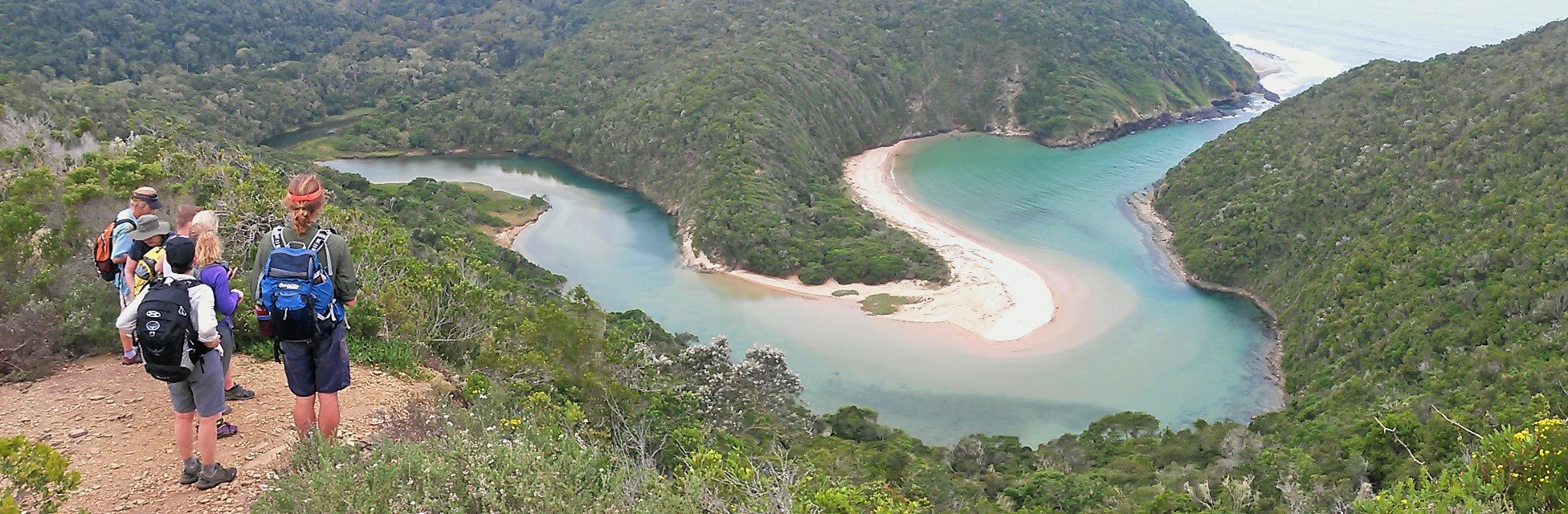
4. Salt River Mouth Trail
Snapshot
Itinerary
The short Salt River Mouth walk explores the quieter western Tsitsikamma coast near Nature’s Valley, linking forested slopes, beach and the Salt River lagoon/mouth. Safe variants should avoid committing to dangerous shoreline sections after storms, rockfall or at high tide.
Because official access information has been unstable, this route should be published with a conservative warning: use only signed/open paths, ask locally at SANParks or Nature’s Valley Rest Camp, and turn back if the shoreline is closed or unsafe.
Why it is essential
It gives the guide a Nature’s Valley day-walk, balancing the Storms River-heavy selection with a wilder, quieter river-mouth landscape.
Hazards and notes
- SANParks lists the Salt River via Keurpad route as closed due to recent floods.
- Shoreline variants can be dangerous after rockfall, storms or at high tide.
- The route should be re-verified just before publication.
GPX / KML links
| Source | URL | Format / access | Reuse status |
|---|---|---|---|
| Wikiloc: Salt River Mouth | wikiloc.com | Download link shown on page; account may be required | Candidate only; old track and shoreline closure comments mean it needs field/current validation |
| SANParks Garden Route Hikes, Walks & Trails | sanparks.org | Official route and closure context | Use for access status; no GPX found |
External links
- SANParks — Nature’s Valley Rest Camp
- SANParks — Garden Route hikes, walks and trails
- Wikiloc — Salt River Mouth
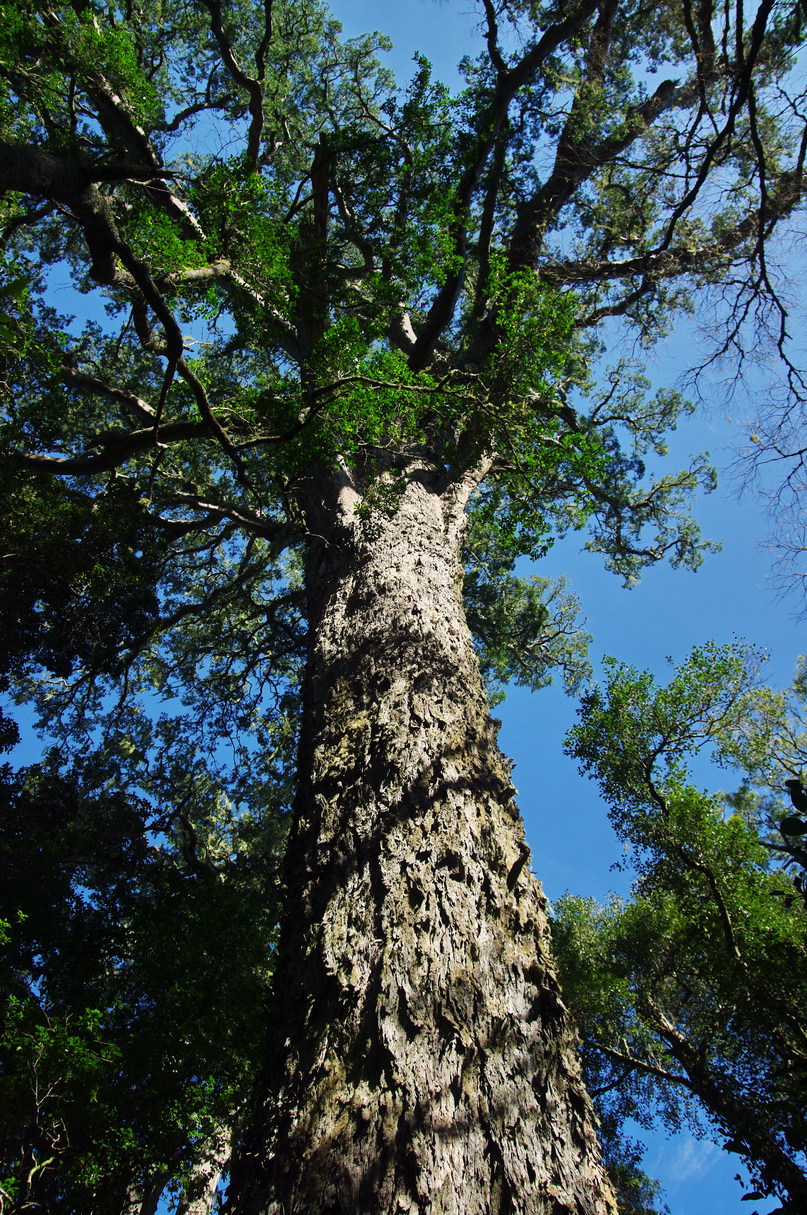
5. Ratel Trail and Tsitsikamma Big Tree
Snapshot
Itinerary
For a quick stop, take the green route on the wooden boardwalk through indigenous forest to the famous Tsitsikamma Big Tree. To make this a proper day-walk entry, continue on the yellow or red Ratel Trail loops through old-growth forest, where the boardwalk gives way to quieter forest path and signed route markers.
This is the most accessible way to represent the inland forest section of the Tsitsikamma Mountains.
Why it is essential
The Big Tree is one of Tsitsikamma’s best-known forest landmarks, and the Ratel Trail turns it from a roadside photo stop into a real forest walk.
Hazards and notes
- Boardwalk and forest paths can be slippery when wet.
- Stay on marked paths to protect roots and forest floor.
- This is not a mountain summit walk, but it is culturally and ecologically important.
GPX / KML links
| Source | URL | Format / access | Reuse status |
|---|---|---|---|
| Wikiloc: Tsitsikamma Big Tree Ratel Route | wikiloc.com | Download link shown on page; account may be required | Good candidate for verification; check if it follows the yellow route plus small detours |
| SANParks Garden Route Hikes, Walks & Trails | sanparks.org | Official route options | Official distance source; no GPX found |
External links
External links
| Source | URL |
|---|---|
| SANParks — Garden Route National Park: Hikes, Walks & Trails | sanparks.org |
| SANParks — Garden Route National Park notifications | sanparks.org |
| SANParks — Storms River Mouth Rest Camp | sanparks.org |
| SANParks — Nature’s Valley Rest Camp | sanparks.org |