Regional overview
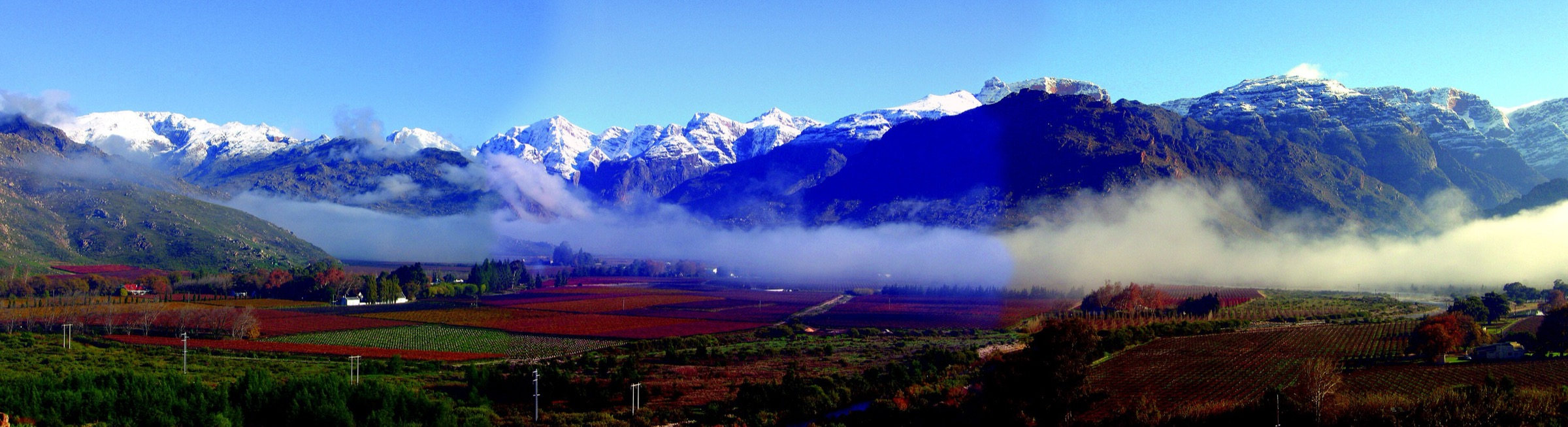
The Hex River Mountains are a high, rugged, access-sensitive Cape Fold Belt range north-east of Worcester and Ceres. Matroosberg reaches 2,249 m and is widely cited as the highest summit in the range and the Boland. The hiking character is more mountaineering-adjacent than tourist-trail: big vertical relief, winter snow, remote huts, private farms, UCT Mountain & Ski Club land, and limited official public trail descriptions.
For this catalogue, the selection is deliberately conservative. Matroosberg has the clearest public hiking page and secondary map statistics. The Waaihoek, Milner, Mostertshoek, and Pells Hut routes are included because they represent the range’s classic high country, but their publication status remains conditional on permit/access confirmation and independent route-line verification.
Selection rationale
The five hikes cover the best-known public summit route, a club-hut approach, two major Waaihoek/Hex high mountain objectives, and a lower Hex River source route. This is a source-led draft rather than a fully polished guidebook entry because official public day-hike data is sparse.
Summary table
| # | Hike | Country | Route type | Distance | Gain | Max elevation | Difficulty | Photo status |
|---|---|---|---|---|---|---|---|---|
| 1 | Matroosberg Peak Hiking Trail | South Africa | Out-and-back summit hike | 14.2 km from AllTrails; official distance not stated | 779 m from AllTrails; official trail starts at 1,250 m and reaches 2,249 m | 2,249 m | Hard / strenuous | No licence-compatible route image found in this pass |
| 2 | Waaihoek Peak approach from Zuurberg side | South Africa | Out-and-back high mountain approach; exact route unresolved | Unresolved in sources used; Waaihoek is a high Hex River peak | Hard; access-sensitive and remote | No licence-compatible route image found in this pass | ||
| 3 | Pells Hut approach | South Africa | Out-and-back hut approach | Approx. 7.7 km from AllTrails listing | Hard | No licence-compatible route image found in this pass | ||
| 4 | Milner Amphitheatre / Milner Peak approach | South Africa | Out-and-back mountain route; exact line unresolved | Approx. 18.8 km from AllTrails nearby listing | Milner Peak area about 1,995 m from secondary range context; route max unresolved | Hard | No licence-compatible route image found in this pass | |
| 5 | Mostertshoek Twins route | South Africa | Out-and-back high mountain route; exact line unresolved | Approx. 19.2 km from AllTrails listing | Mostertshoek Twins Peak 2,031 m from CapeNature PAMP context; route max unresolved | Hard | No licence-compatible route image found in this pass |
1. Matroosberg Peak Hiking Trail
Snapshot
Itinerary
The official Matroosberg hiking trail starts at about 1,250 m and climbs toward Matroosberg Peak at 2,249 m. The reserve says the route has been used by the Ski Club since 1929 and can be completed in 8 to 10 hours.
The route climbs from the farm/reserve basin through rocky mountain slopes to the summit plateau. Secondary trail notes mention rock formations, rock pools lower down, and winter snow conditions. Treat the summit as a serious high-mountain day with early start and firm turnaround time.
Why it is essential
Matroosberg is the defining public summit objective of the Hex River Mountains and the clearest source-backed way to experience the range’s high, cold, wind-exposed character.
Equipment
- Sturdy hiking shoes or boots with grip for sandstone, loose quartzite, forest roots, and wet rock.
- Sun hat, sunglasses, sunscreen, and enough water for exposed Cape Fold Belt conditions.
- Warm layer, windproof/rain shell, headlamp, first-aid kit, food, and offline map/GPS backup.
- Valid reserve, private-land, or national-park permit where required.
Hazards and notes
- Weather changes quickly; wind, mist, winter cold, and summer heat can all become serious.
- Fire closures, flood damage, reserve gate times, and permit rules should be checked before publication or field use.
- Cell coverage can be absent in kloofs, wilderness areas, and higher mountain basins.
- Snakes, baboons, loose rock, river crossings, and slippery wet rock are plausible route hazards.
- Snow, ice, hypothermia, and whiteout are realistic in winter and after cold fronts.
- The route is long enough that gate/exit times and daylight must be planned.
Photos
Photo status: No licence-compatible route image found in this pass.
| Image / subject | Image URL | Source page URL | Author | Licence | Reuse notes | Attribution |
|---|---|---|---|---|---|---|
| Unresolved | Unresolved | Unresolved | Unresolved | Unresolved | No licence-compatible image found in this pass | Unresolved |
GPX / KML links
| Source | URL | Format | Licence / terms | Reuse status |
|---|---|---|---|---|
| Matroosberg official hiking page | matroosberg.com | Official route description; no GPX found | Matroosberg website terms | Use for factual verification; no route file |
| AllTrails: Matroosberg Nature Reserve | alltrails.com | Source route map / GPX via AllTrails | AllTrails terms apply | Stats/geometry source only; route-file reuse not confirmed |
External links
- Matroosberg — Hiking page
- AllTrails — Matroosberg Nature Reserve
- CapeNature — Hexrivier Complex PAMP (PDF)
2. Waaihoek Peak approach from Zuurberg side
Snapshot
Itinerary
Waaihoek is included as a classic Hex River high-country objective, but a publication-ready day-hike line was not verified in this pass. SummitPost and secondary sources identify Waaihoek in the Hex River massif, while AllTrails nearby listings confirm that several Zuurberg/club-property routes exist.
Before publication, this entry needs the exact permitted trailhead, owner/club permission process, GPX line, ascent/descent, and objective-hazard review. Until then, treat it as a selected essential objective rather than a ready-to-walk route description.
Why it is essential
Waaihoek represents the less-public, rugged club-mountaineering side of the Hex River Mountains: high ridges, snow-prone terrain, and serious Cape Fold Belt relief.
Equipment
- Sturdy hiking shoes or boots with grip for sandstone, loose quartzite, forest roots, and wet rock.
- Sun hat, sunglasses, sunscreen, and enough water for exposed Cape Fold Belt conditions.
- Warm layer, windproof/rain shell, headlamp, first-aid kit, food, and offline map/GPS backup.
- Valid reserve, private-land, or national-park permit where required.
Hazards and notes
- Weather changes quickly; wind, mist, winter cold, and summer heat can all become serious.
- Fire closures, flood damage, reserve gate times, and permit rules should be checked before publication or field use.
- Cell coverage can be absent in kloofs, wilderness areas, and higher mountain basins.
- Snakes, baboons, loose rock, river crossings, and slippery wet rock are plausible route hazards.
- Unverified access and route geometry are the main hazard for guidebook publication.
- Remote terrain, possible snow/ice, and limited rescue access require a conservative party and plan.
Photos
Photo status: No licence-compatible route image found in this pass.
| Image / subject | Image URL | Source page URL | Author | Licence | Reuse notes | Attribution |
|---|---|---|---|---|---|---|
| Unresolved | Unresolved | Unresolved | Unresolved | Unresolved | No licence-compatible image found in this pass | Unresolved |
GPX / KML links
| Source | URL | Format | Licence / terms | Reuse status |
|---|---|---|---|---|
| SummitPost: Hex River Mountains | summitpost.org | Mountaineering overview; no GPX selected | SummitPost terms apply | Context only; route-file reuse not applicable |
| AllTrails Ceres walking routes listing | alltrails.com | Trail listing/source-map gateway | AllTrails terms apply | Candidate source only; no route file selected |
External links
- SummitPost — Hex River Mountains overview
- AllTrails — Ceres walking trails listing
- CapeNature — Hexrivier Complex PAMP (PDF)
3. Pells Hut approach
Snapshot
Itinerary
The Pells Hut route is a compact but steep access walk into the UCT Mountain & Ski Club side of the Hex River Mountains. The route is included because it represents the hut-and-club access pattern that defines much of the range.
The exact trailhead, parking, and hut-permit process must be checked with the club before any field use. Treat the AllTrails listing as a pointer to geometry, not as a complete legal access source.
Why it is essential
Pells Hut is a practical window into the Hex River Mountains’ protected club-land hiking culture and gives the catalogue an objective shorter than the big summit days while still retaining mountain seriousness.
Equipment
- Sturdy hiking shoes or boots with grip for sandstone, loose quartzite, forest roots, and wet rock.
- Sun hat, sunglasses, sunscreen, and enough water for exposed Cape Fold Belt conditions.
- Warm layer, windproof/rain shell, headlamp, first-aid kit, food, and offline map/GPS backup.
- Valid reserve, private-land, or national-park permit where required.
Hazards and notes
- Weather changes quickly; wind, mist, winter cold, and summer heat can all become serious.
- Fire closures, flood damage, reserve gate times, and permit rules should be checked before publication or field use.
- Cell coverage can be absent in kloofs, wilderness areas, and higher mountain basins.
- Snakes, baboons, loose rock, river crossings, and slippery wet rock are plausible route hazards.
- Permission and parking errors could invalidate the route; verify before publication.
- Remote hut approaches can still involve steep terrain and poor weather exposure.
Photos
Photo status: No licence-compatible route image found in this pass.
| Image / subject | Image URL | Source page URL | Author | Licence | Reuse notes | Attribution |
|---|---|---|---|---|---|---|
| Unresolved | Unresolved | Unresolved | Unresolved | Unresolved | No licence-compatible image found in this pass | Unresolved |
GPX / KML links
| Source | URL | Format | Licence / terms | Reuse status |
|---|---|---|---|---|
| AllTrails Ceres walking routes listing: Pells Hut | alltrails.com | Trail listing/source-map gateway | AllTrails terms apply | Candidate GPX/source-map only; exact file reuse unresolved |
| SummitPost Hex River Mountains overview | summitpost.org | Access/context overview | SummitPost terms apply | Context only; no route file |
External links
- AllTrails — Ceres walking trails listing (Pells Hut access)
- SummitPost — Hex River Mountains overview
4. Milner Amphitheatre / Milner Peak approach
Snapshot
Itinerary
Milner Amphitheatre is included as a source-led candidate for the dramatic cliff-and-basin side of the Hex River Mountains. Secondary route listings place a hard route of about 18.8 km in the area, but the exact line, trailhead, and legal access were not fully verified.
A final version should inspect a GPX line against OSM/topographic mapping and confirm whether the route reaches Milner Peak, an amphitheatre viewpoint, or a lower turnaround. Until then, this remains a detailed but conditional catalogue selection.
Why it is essential
Milner is one of the named high Hex River landmarks and gives the region a dramatic ridge/amphitheatre objective beyond the better-publicised Matroosberg route.
Equipment
- Sturdy hiking shoes or boots with grip for sandstone, loose quartzite, forest roots, and wet rock.
- Sun hat, sunglasses, sunscreen, and enough water for exposed Cape Fold Belt conditions.
- Warm layer, windproof/rain shell, headlamp, first-aid kit, food, and offline map/GPS backup.
- Valid reserve, private-land, or national-park permit where required.
Hazards and notes
- Weather changes quickly; wind, mist, winter cold, and summer heat can all become serious.
- Fire closures, flood damage, reserve gate times, and permit rules should be checked before publication or field use.
- Cell coverage can be absent in kloofs, wilderness areas, and higher mountain basins.
- Snakes, baboons, loose rock, river crossings, and slippery wet rock are plausible route hazards.
- Potential exposure, route-finding, and private-access complexity are unresolved.
- Long distance and high relief require an early start and competent navigation.
Photos
Photo status: No licence-compatible route image found in this pass.
| Image / subject | Image URL | Source page URL | Author | Licence | Reuse notes | Attribution |
|---|---|---|---|---|---|---|
| Unresolved | Unresolved | Unresolved | Unresolved | Unresolved | No licence-compatible image found in this pass | Unresolved |
GPX / KML links
| Source | URL | Format | Licence / terms | Reuse status |
|---|---|---|---|---|
| AllTrails Ceres walking routes listing: Milner Amphitheatre | alltrails.com | Trail listing/source-map gateway | AllTrails terms apply | Candidate source only; exact GPX reuse unresolved |
| SummitPost Hex River Mountains overview | summitpost.org | Mountaineering overview | SummitPost terms apply | Context only |
External links
- AllTrails — Ceres walking trails listing
- SummitPost — Hex River Mountains overview
- CapeNature — Hexrivier Complex PAMP (PDF)
5. Mostertshoek Twins route
Snapshot
Itinerary
The Mostertshoek Twins form a high western objective in the Hex River Mountains. CapeNature’s protected-area plan identifies Mostertshoek Twins Peak among the high points of the Hexrivier Complex, while AllTrails listings indicate a hard route in the 19 km range.
A final guidebook route needs the permitted start point, landowner/club permission, water notes, and GPX verification. It is retained here because omitting the western high ridge would make the Hex River entry too Matroosberg-centric.
Why it is essential
The Twins represent the high western Waaihoek/Hex skyline and balance the public Matroosberg route with a more remote mountain objective.
Equipment
- Sturdy hiking shoes or boots with grip for sandstone, loose quartzite, forest roots, and wet rock.
- Sun hat, sunglasses, sunscreen, and enough water for exposed Cape Fold Belt conditions.
- Warm layer, windproof/rain shell, headlamp, first-aid kit, food, and offline map/GPS backup.
- Valid reserve, private-land, or national-park permit where required.
Hazards and notes
- Weather changes quickly; wind, mist, winter cold, and summer heat can all become serious.
- Fire closures, flood damage, reserve gate times, and permit rules should be checked before publication or field use.
- Cell coverage can be absent in kloofs, wilderness areas, and higher mountain basins.
- Snakes, baboons, loose rock, river crossings, and slippery wet rock are plausible route hazards.
- Unresolved access and route-line details are material; do not publish as ready-to-walk until confirmed.
- High ridge weather and route-finding could be serious.
Photos
Photo status: No licence-compatible route image found in this pass.
| Image / subject | Image URL | Source page URL | Author | Licence | Reuse notes | Attribution |
|---|---|---|---|---|---|---|
| Unresolved | Unresolved | Unresolved | Unresolved | Unresolved | No licence-compatible image found in this pass | Unresolved |
GPX / KML links
| Source | URL | Format | Licence / terms | Reuse status |
|---|---|---|---|---|
| AllTrails Ceres walking routes listing: Mostertshoek Twins | alltrails.com | Trail listing/source-map gateway | AllTrails terms apply | Candidate source only; exact GPX reuse unresolved |
| CapeNature Hexrivier Complex PAMP | capenature.co.za | Official protected-area context PDF | CapeNature terms | Context/elevation verification; no route file |
External links
- CapeNature — Hexrivier Complex PAMP (PDF)
- AllTrails — Ceres walking trails listing
- SummitPost — Hex River Mountains overview
Missing data and follow-up
- Official GPX/KML files were not found for Hex River day hikes in this pass.
- Access permissions for UCT Mountain & Ski Club Zuurberg land, private farms, Waaihoek, Milner, and Mostertshoek must be checked before publication.
- Open-licence, route-specific photos were not verified for these hikes.
- Several route statistics are from AllTrails listings or search snippets only and should be recalculated from independent GPX before final guidebook use.
External links
| Source | URL |
|---|---|
| Matroosberg — Hiking page | matroosberg.com |
| AllTrails — Matroosberg Nature Reserve | alltrails.com |
| AllTrails — Ceres walking trails listing | alltrails.com |
| SummitPost — Hex River Mountains overview | summitpost.org |
| CapeNature — Hexrivier Complex PAMP (PDF) | capenature.co.za |