Regional overview
The Cederberg is the orange-sandstone heart of the northern Cape Fold Belt: a rugged mountain wilderness of Table Mountain sandstone ridges, narrow cracks, freestanding rock towers, fynbos plateaus, remnant cedar trees, waterfalls, and San/Khoi rock-art sites. It is one of South Africa’s great walking landscapes: dry, exposed, visually dramatic, and often far more remote than its road access suggests.
This guide focuses on five essential Cederberg day walks. Together, they cover the region’s signature hiking themes: adventurous sandstone scrambling, iconic rock formations, waterfall objectives, Algeria valley viewpoints, and the cultural-geology sites of Matjiesrivier.
Most Cederberg hikes require permits, weather checks, early starts in hot conditions, and strong self-sufficiency. In the Cederberg Wilderness, CapeNature asks hikers not to walk with fewer than three adults. Shorter walks such as Stadsaal Cave and Truitjieskraal are less physically demanding, but still require respect for heat, fragile sandstone, rock art, gravel-road access, and the lack of services once away from the main settlements.
Selection rationale
These five routes were chosen to give a balanced first Cederberg hiking set:
- Wolfberg Cracks and Wolfberg Arch — the classic adventurous sandstone day.
- Maltese Cross — the most accessible iconic rock-tower walk.
- Algeria Waterfall / Middelberg Waterfall — the essential waterfall hike from Algeria.
- Stadsaal Cave and Truitjieskraal — the key short cultural-geology outing.
- Uitkyk Trail from Algeria — the compact Algeria valley viewpoint walk.
Sneeuberg and Tafelberg are major Cederberg mountain objectives, but they have been left out of this five-hike selection because this pass did not verify a clean, non-technical day-hike line with complete access details and reliable statistics.
Summary table
| # | Hike | Route type | Distance | Elevation gain | Max elevation | Difficulty |
|---|---|---|---|---|---|---|
| 1 | Wolfberg Cracks and Wolfberg Arch | Out-and-back or lollipop variant | c. 12.2–16.7 km | c. +790–875 m | c. 1,545 m | Hard / strenuous |
| 2 | Maltese Cross | Out-and-back | c. 6.3–7 km | c. +440 m | Moderate to hard | |
| 3 | Algeria Waterfall / Middelberg Waterfall | Out-and-back | c. 5.0 km | c. +379 m | Moderate | |
| 4 | Stadsaal Cave and Truitjieskraal | Short interpretive walk | Minor | Easy to moderate | ||
| 5 | Uitkyk Trail from Algeria | Out-and-back viewpoint walk | Moderate |
Before you go
Permits and access
Most hikes in this article require a permit, day-access arrangement, or private-land/reserve permission. Sanddrif, Algeria, CapeNature, Matjiesrivier, and private access points should be checked before travel. Some trailheads are reached by gravel roads, and road conditions can change after storms or fires.
Standard Cederberg day-hiking kit
For all five routes, carry:
- Sturdy hiking shoes or boots with good grip on sandstone, loose quartzite, and wet rock.
- Sun hat, sunglasses, sunscreen, and more water than you would usually carry for a hike of the same distance.
- Warm layer, windproof/rain shell, food, first-aid kit, headlamp, and offline map/GPS backup.
- Valid permit or day-access proof where required.
- A fully charged phone, but do not rely on mobile coverage.
For Wolfberg Cracks and Wolfberg Arch, add a higher margin of safety: navigation backup, an early start, enough water for an exposed full day, and confidence with scrambling and tight rock passages.
Common hazards
The Cederberg is dry, exposed, and deceptively serious. The main hazards are heat, dehydration, sudden weather changes, poor visibility, loose rock, slippery wet sandstone, snakes, baboons, river crossings after rain, fire closures, and long distances from help. Rock-art sites are fragile and legally protected: do not touch paintings, climb on marked panels, or leave graffiti.
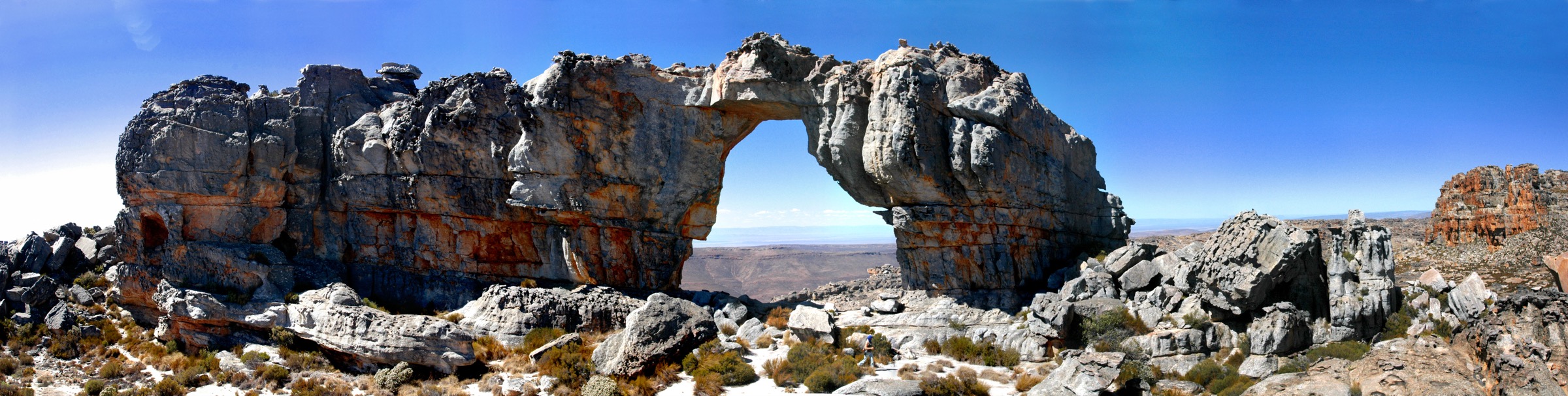
1. Wolfberg Cracks and Wolfberg Arch
Snapshot
Itinerary
Wolfberg Cracks and Wolfberg Arch is the Cederberg’s benchmark adventure day. From the Sanddrif/Dwarsrivier side, the trail climbs steeply into the Wolfberg Cracks: a maze of narrow sandstone clefts, chockstones, polished rock, sandy ledges, and tight passages. The classic line requires hands-on scrambling and, in places, squeezing through or around blocks.
Above the Cracks, the route opens onto an exposed sandstone plateau. From here, continue across fynbos, slabs, and open rock toward Wolfberg Arch, a huge natural sandstone opening and one of the Cederberg’s defining landmarks. Most parties return by the same general line, though some mapped variants use a wider crack or alternative descent. Do not choose a descent line casually: check it locally and avoid committing to an unknown crack late in the day.
Why it is essential
This is the most complete single-day expression of the Cederberg: steep mountain walking, adventurous sandstone architecture, a high plateau crossing, and the monumental Wolfberg Arch.
Hazards and notes
- Start early, especially in warm weather.
- The Cracks involve scrambling, tight squeezes, and fall consequences.
- The plateau has little shade and can be confusing in poor visibility.
- Carry a headlamp even on a day hike; delays are common on this route.
- CapeNature rules and permit conditions should be checked before publication or field use.
GPX / KML links
| Source | URL | Format | Notes |
|---|---|---|---|
| CapeNature Cederberg Wilderness page | capenature.co.za | Official route description/time; no GPX found | Use for factual verification and permit notes; not a reusable route file |
| Outdooractive: Wolfberg Arch via the Cracks | outdooractive.com | Source route map / GPX via Outdooractive | Geometry/stat source only; route-file reuse not confirmed |
| AllTrails: Wolfberg Arch via Die Trap | alltrails.com | Source route map / GPX via AllTrails | Alternate route geometry; reuse not confirmed |
External links
- CapeNature Cederberg Wilderness route notes and permits
- CapeNature Cederberg hiking rules
- Outdooractive route page for Wolfberg Arch via the Cracks
- AllTrails route page for the longer Die Trap variant
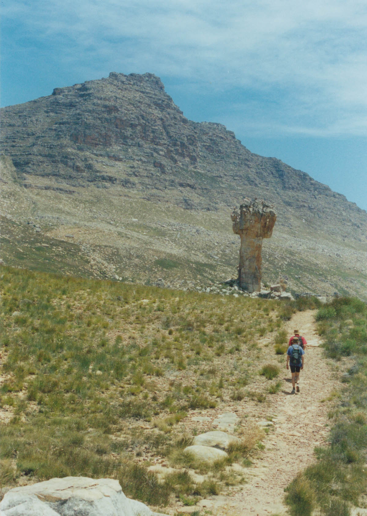
2. Maltese Cross
Snapshot
Itinerary
The Maltese Cross walk is shorter and less committing than Wolfberg Arch, but it still gives a classic Cederberg experience. The path climbs from the Sanddrif side through open fynbos and sandstone country toward the famous freestanding rock pillar. The terrain is generally more straightforward than the Wolfberg Cracks, though the heat, exposure, and reflective sandstone can make the hike feel harder than its distance suggests.
The Maltese Cross stands below the higher Cederberg peaks, with Sneeuberg forming part of the classic backdrop. Return by the same trail, keeping to the established line to protect fragile soils and vegetation.
Why it is essential
The Maltese Cross is one of the Cederberg’s most recognisable sandstone landmarks. It is a compact, high-value walk for hikers who want a major rock formation without committing to a full-day scramble.
Hazards and notes
- The route is exposed, with limited shade.
- Late-afternoon light can be beautiful, but avoid returning in darkness.
- Heat can turn a moderate walk into a serious outing.
- Stay on the path around the rock formation to reduce erosion.
GPX / KML links
| Source | URL | Format | Notes |
|---|---|---|---|
| CapeNature Cederberg Wilderness page | capenature.co.za | Official route description/time; no GPX found | Use for factual verification and permits; no route file |
| AllTrails: Maltese Cross | alltrails.com | Source route map / GPX via AllTrails | Stats/geometry source only; route-file reuse not confirmed |
External links
3. Algeria Waterfall / Middelberg Waterfall Trail
Snapshot
Itinerary
From the Algeria campsite area, the trail climbs toward Middelberg / Algeria Waterfall. CapeNature describes it as a moderately steep, well-marked route and a pleasant hike with a picnic objective. The walk rises from the Rondegat River valley into rocky Cederberg slopes, reaching the waterfall and pool area before returning by the same route.
This is a shorter hike than the Sanddrif classics, but it should not be treated as casual in hot weather. The route has exposed sections, rocky footing, and slippery areas around the waterfall, especially after rain.
Why it is essential
This is the essential day walk from Algeria: accessible, scenic, and varied, with a clear mountain objective and a different character from the dry sandstone-plateau routes.
Hazards and notes
- Waterfall rocks and stream edges can be slippery.
- Water should be treated before drinking.
- The route is best after some rainfall, but wet conditions also increase slip risk.
- Algeria is reached by gravel road; road conditions should be checked before travel.
GPX / KML links
| Source | URL | Format | Notes |
|---|---|---|---|
| CapeNature Cederberg Wilderness page | capenature.co.za | Official route description/time; no GPX found | Use for factual verification and permits; no route file |
| AllTrails: Algeria Waterfall | alltrails.com | Source route map / GPX via AllTrails | Stats/geometry source only; route-file reuse not confirmed |
External links
- CapeNature Cederberg Wilderness hiking section
- CapeNature Algeria information sheet
- AllTrails Algeria Waterfall page
4. Stadsaal Cave and Truitjieskraal interpretive walk
Snapshot
Itinerary
Stadsaal Cave and Truitjieskraal are best treated as a combined cultural-geology day outing rather than a fitness hike. At Stadsaal Cave, a short circuit from the parking area explores wind-eroded sandstone formations, including the main cavern and surrounding openings. CapeNature describes the Stadsaal circuit as a leisurely walk of about 30 minutes, though many visitors spend longer examining the formations.
At Truitjieskraal, the marked interpretive route gives access to sandstone forms and rock-art context. Stay on marked paths, do not touch rock art, and do not climb on protected surfaces. These sites are short, but they are central to understanding why the Cederberg is more than just a mountain-walking destination.
Why it is essential
The Cederberg’s identity is inseparable from its rock art and sculpted sandstone architecture. Stadsaal and Truitjieskraal make that heritage accessible in a short, memorable outing.
Hazards and notes
- No drinking water is available at Stadsaal Cave or Truitjieskraal according to CapeNature.
- The sites are reached by gravel road; suitable transport and road-condition checks matter.
- Rock art is fragile and legally protected.
- Avoid visiting in extreme heat.
- Do not treat the short distance as a reason to skip water, sun protection, or navigation.
GPX / KML links
| Source | URL | Format | Notes |
|---|---|---|---|
| CapeNature Matjiesrivier day visitor information sheet | capenature.co.za | Official site/walk information; no GPX found | Use for factual verification; no route file |
| OpenStreetMap search: Stadsaal Cave | openstreetmap.org | Map/source geometry cross-check | OSM-derived data would require ODbL attribution |
External links
5. Uitkyk Trail from Algeria
Snapshot
Itinerary
The Uitkyk Trail is a short but steep viewpoint walk from Algeria. CapeNature highlights it for views over the Cederberg Mountains and the Algeria valley, making it a useful half-day objective for arrival or departure day.
The walk is a natural counterpart to the Algeria Waterfall route. Where the waterfall hike follows a wetter kloof objective, Uitkyk climbs toward a drier viewpoint above the campsite basin and surrounding sandstone ridges. Its statistics still need verification, but its role in the hiking set is clear: this is the compact Algeria panorama walk.
Why it is essential
Uitkyk gives the northern Cederberg entry point its essential viewpoint hike: official, relatively short, and strongly representative of Algeria’s mountain-valley setting.
Hazards and notes
- Short, steep ground can still be hazardous in heat, mist, or strong wind.
- Detailed distance and elevation gain were not verified in this pass.
- Use CapeNature/Forge maps before field publication.
- Start early in hot weather.
- Carry enough water even if the hike looks short on the map.
GPX / KML links
| Source | URL | Format | Notes |
|---|---|---|---|
| CapeNature Cederberg Wilderness page | capenature.co.za | Official route description/time; no GPX found | Use for factual verification and permits; no route file |
| Forge/CapeNature trail maps link from CapeNature | forgesa.com | Digital trail-map source referenced by CapeNature | Use as navigation/source map; route-file reuse unresolved |
External links
External links
| Source | URL |
|---|---|
| CapeNature Cederberg Wilderness Area | capenature.co.za |
| CapeNature Cederberg brochure PDF | capenature.co.za |
| CapeNature Algeria information sheet | capenature.co.za |
| CapeNature Cederberg hiking and overnight rules | capenature.co.za |
| CapeNature Matjiesrivier day visitor information sheet | capenature.co.za |