Regional overview
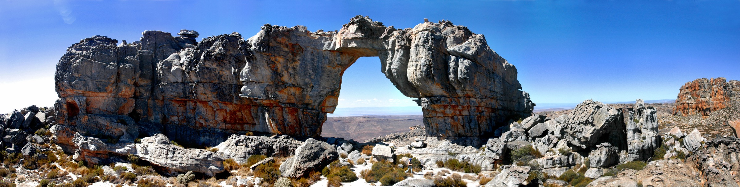
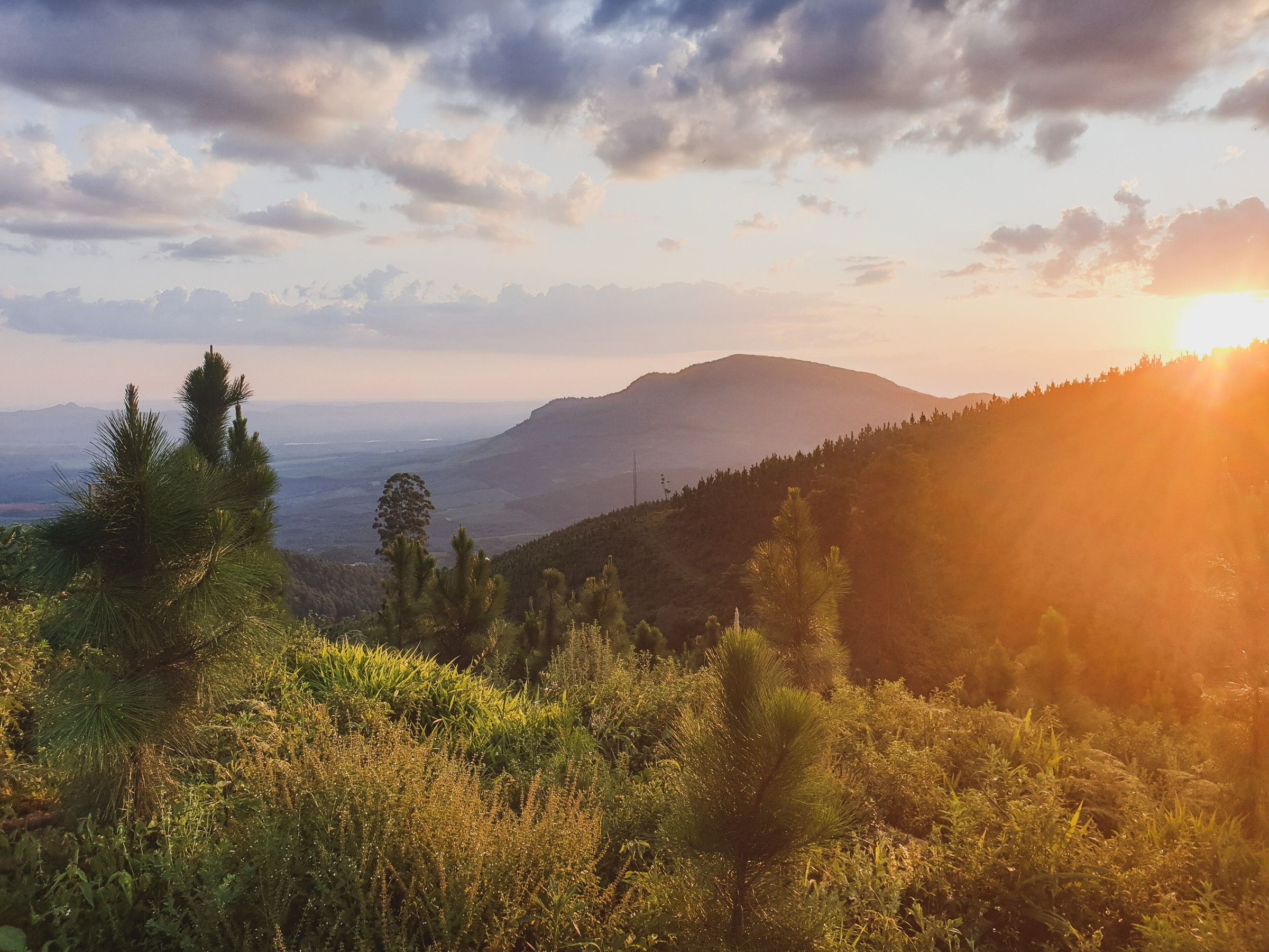
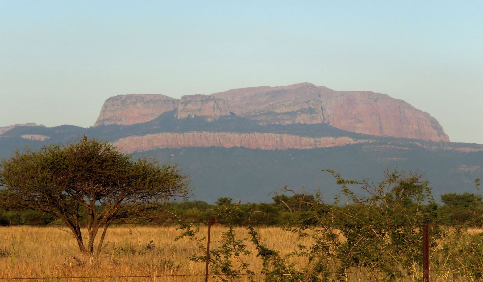
Blouberg is a remote mountain-and-bushveld area in northern Limpopo, west of the Soutpansberg and close to Vivo. The landscape combines steep cliffs, savanna, baobab and tamboti woodland, small forest patches, natural pools, cultural routes and one of southern Africa’s important Cape vulture sites. Limpopo Wildlife Resorts describes Blouberg Nature Reserve as a core conservation area within the Vhembe Biosphere Reserve, with a prominent mountain rising above lowveld bushveld and a major Cape vulture breeding colony.
This is not a region with abundant public hiking data. Unlike better-documented South African hiking areas, Blouberg has very few public GPX tracks, few published route statistics and several access questions that need local confirmation. The one route with modern public statistics is the AllTrails Blouberg out-and-back, listed as a hard 15.4 km route with 979 m of elevation gain and an estimated time of around 6.5–7 hours.
The remaining four entries are included because they represent the essential walking themes of Blouberg: the guided vulture trail, the cultural-camp mountain trail, the potholes and natural-pools walk, and a lower reserve forest / big-tree walk. These are not yet fully route-verified. They should be treated as research targets or locally guided walks until current route geometry, access rules, distances and safety conditions are confirmed.
Selection rationale
This guide keeps exactly five entries, but separates verified route data from candidate-only material. The goal is to give a useful regional hiking article without pretending that unresolved routes have confirmed statistics. The selection covers:
- Blouberg high route to yellowwoods and pools — the best-documented high mountain route.
- Blouberg Nature Reserve guided Vulture Trail — the reserve’s vulture-cliff experience.
- Blouberg Cultural Camp to mountain community trail — the African Ivory Route / community mountain trail.
- Blouberg Cultural Camp potholes and natural-pools walk — the cultural-camp lower walk.
- Blouberg Nature Reserve fig forest / big-tree walk — a lower reserve forest and big-tree walk.
Summary table
| # | Hike | Area | Route type | Distance | Elevation gain | Estimated time | Difficulty |
|---|---|---|---|---|---|---|---|
| 1 | Blouberg high route to yellowwoods and pools | Blouberg mountain / Nature Reserve context | Out-and-back | 15.4 km | 979 m | 6.5–7 hr | Hard |
| 2 | Blouberg Nature Reserve guided Vulture Trail | Blouberg Nature Reserve | Guided out-and-back or loop | TBC | TBC | TBC | Moderate to hard, likely |
| 3 | Blouberg Cultural Camp to mountain community trail | African Ivory Route / Blouberg Cultural Camp | Out-and-back or guided traverse | 3 km one-way reported | TBC | Up to 3 hr ascent reported | Hard |
| 4 | Blouberg Cultural Camp potholes and natural-pools walk | Blouberg Cultural Camp / African Ivory Route | Out-and-back | TBC | TBC | TBC | Easy to moderate, likely |
| 5 | Blouberg Nature Reserve fig forest / big-tree walk | Blouberg Nature Reserve lower mountain | Loop or out-and-back | TBC | TBC | TBC | Easy to moderate, likely |
Before you go
Required equipment
Blouberg is remote, hot, steep and less documented than mainstream hiking areas. The same baseline equipment applies across all five walks:
- Sturdy hiking footwear.
- Sun hat, sunglasses and high-factor sunscreen.
- More water than usual for the stated distance.
- Offline map, GPS track where available and a backup navigation method.
- First-aid kit, headtorch and warm layer.
- Trekking poles for the steeper mountain routes.
- Booking confirmation or written access guidance where required.
- Binoculars for the Vulture Trail and reserve birding; a dry bag if photography or electronics will be carried near pools.
Current access and safety notes
- Treat all walks here as access-sensitive. Confirm permission, guiding requirements and trail condition before setting out.
- Key risks include heat, limited water, weak phone coverage, cliffs, rough ground, wildlife, possible dangerous game, seasonal storms and long rescue times.
- The reserve context includes buffalo, sable antelope and other wildlife. Blouberg is also a significant birding and Cape vulture conservation area; follow reserve guidance for cliff-edge and colony rules.
- Public GPX availability is weak. Where no reusable route file is available, use only a source link until a verified GPX has been created from field survey, operator permission or independently confirmed coordinates.
- The cooler dry months are the safer planning window; avoid severe heat and storms.
1. Blouberg high route to yellowwoods and pools
Snapshot
Itinerary
This is the strongest candidate for a fully publishable Blouberg day hike because it has a modern public route listing with distance, ascent, route type and time estimate. AllTrails lists the route as a hard 15.4 km out-and-back with 979 m of elevation gain, taking around 6.5–7 hours.
The route enters the mountain terrain above the surrounding bushveld and is associated with Blouberg’s dramatic views, forested patches, natural pools, yellowwood trees and wildlife. The route should still be treated cautiously: the public statistics are useful, but the legal access point, permit process and guide requirement should be confirmed before publication or use.
Why it is essential
This is the only Blouberg route found with enough public statistics to support a proper hiking entry. It also represents the massif’s core appeal: a long, steep mountain day with forest, cliffs, pools and wide Limpopo views.
Hazards and notes
- Long ascent of nearly 1,000 m.
- Remote terrain and limited public route information.
- Heat exposure in warmer months.
- Possible cliffs, loose rock and weak waymarking.
- Permit or access uncertainty.
GPX / KML links
| Source | URL | Format / access | Reuse status |
|---|---|---|---|
| AllTrails: Blouberg | alltrails.com | Route page / app route | Useful for statistics and source checking; direct GPX reuse not confirmed |
External links
2. Blouberg Nature Reserve guided Vulture Trail
Snapshot
Itinerary
The guided Vulture Trail is one of the most important Blouberg walking experiences even though the route statistics remain unresolved. Limpopo Wildlife Resorts states that visitors can book a guided trail to the plateau above the Cape vulture colony, giving close views of vultures in flight.
BirdLife South Africa also highlights the reserve’s vulture restaurant, hide and nearby Cape vulture colony, and notes that winter months are especially good for vulture viewing.
Why it is essential
The Cape vulture colony is one of Blouberg’s defining natural features. A Blouberg hiking guide that omits the vulture trail would miss the reserve’s most distinctive conservation experience.
Hazards and notes
- Cliff exposure.
- Conservation restrictions around the colony.
- Heat and limited shade.
- Wildlife and reserve access controls.
- Unknown distance and ascent — avoid approaching colony areas without authorisation.
GPX / KML links
| Source | URL | Format / access | Reuse status |
|---|---|---|---|
| Limpopo Wildlife Resorts: Blouberg Nature Reserve | lwr.gov.za | Official reserve activity page | Confirms the guided Vulture Trail; no GPX or route statistics found |
External links
3. Blouberg Cultural Camp to mountain community trail
Snapshot
Itinerary
This entry represents the cultural and community side of Blouberg rather than only the reserve and mountain scenery. The draft source material describes a steep community-linked trail from the Blouberg Cultural Camp area towards a mountain community or upper camp, with a reported 3 km climb. The route is described as rocky, steep and physically demanding.
Love Limpopo confirms the broader setting: the African Ivory Route Blouberg Cultural Camp is tucked into the mountainside, with walks to potholes and longer hikes towards a self-sufficient community at the top of the mountains.
Why it is essential
Blouberg is not only a nature reserve. The mountain sits in a cultural landscape of villages, community tourism, rock art and African Ivory Route heritage. This route is essential because it gives the region a human and cultural walking dimension.
Hazards and notes
- Steep rocky terrain.
- Possible scrambling.
- Heat exposure.
- Access uncertainty.
- Potential confusion between old tourism descriptions and current operation. Do not attempt the route without confirmed local access information.
GPX / KML links
| Source | URL | Format / access | Reuse status |
|---|---|---|---|
| Love Limpopo: Blouberg hiking context | lovelimpopo.com | Tourism context page | Confirms cultural-camp, potholes and longer mountain-hike context; no GPX found |
External links
4. Blouberg Cultural Camp potholes and natural-pools walk
Snapshot
Itinerary
This is the most approachable candidate walk in the Blouberg Cultural Camp area. Love Limpopo describes a walk from the Blouberg Cultural Camp to potholes where visitors can cool off, with longer mountain options beyond.
The route has obvious visitor appeal, but it cannot yet be published as a complete hike because no current route line, distance, ascent or access process was found in the reviewed material.
Why it is essential
The potholes and pools provide a lower-mountain objective that balances the harder summit-style hikes. This makes the Blouberg selection more rounded: not every worthwhile walk in the area has to be a long, steep ascent.
Hazards and notes
- Slippery rock around pools.
- Flash-flood risk after storms.
- Heat and dehydration.
- Possible access restrictions.
- Unclear trail condition.
GPX / KML links
| Source | URL | Format / access | Reuse status |
|---|---|---|---|
| Love Limpopo: Blouberg hiking context | lovelimpopo.com | Tourism context page | Confirms the potholes / natural-pools walking concept; no GPX or statistics found |
External links
5. Blouberg Nature Reserve fig forest / big-tree walk
Snapshot
Itinerary
This candidate walk is built around the lower reserve’s habitat diversity rather than a high mountain objective. Limpopo Wildlife Resorts describes the reserve as having tamboti woodland, fig forest, baobabs and the Brak River flood plain, and lists hiking and walking trails among available activities.
BirdLife South Africa also describes the reserve as including a small sycamore fig forest, tamboti woodland, dams, woodland habitats and more than 270 bird species.
A publishable walk could link forest, big-tree, lookout, fountain or camp-area features if the reserve confirms an official trail line. At present, this should remain a candidate lower-reserve walk.
Why it is essential
The lower reserve gives Blouberg a different character: bushveld, forest patches, birding, large trees and wildlife rather than only steep mountain climbing. It also offers the best chance of a gentler route if current reserve access rules allow it.
Hazards and notes
- Wildlife and possible dangerous game.
- Unclear walking permissions.
- Heat and limited shade outside forest patches.
- Possible need for high-clearance or 4x4 access in parts of the reserve.
- Lack of public route geometry.
GPX / KML links
| Source | URL | Format / access | Reuse status |
|---|---|---|---|
| Limpopo Wildlife Resorts: Blouberg Nature Reserve | lwr.gov.za | Official reserve activity page | Confirms hiking and walking activities; no route file or statistics found |
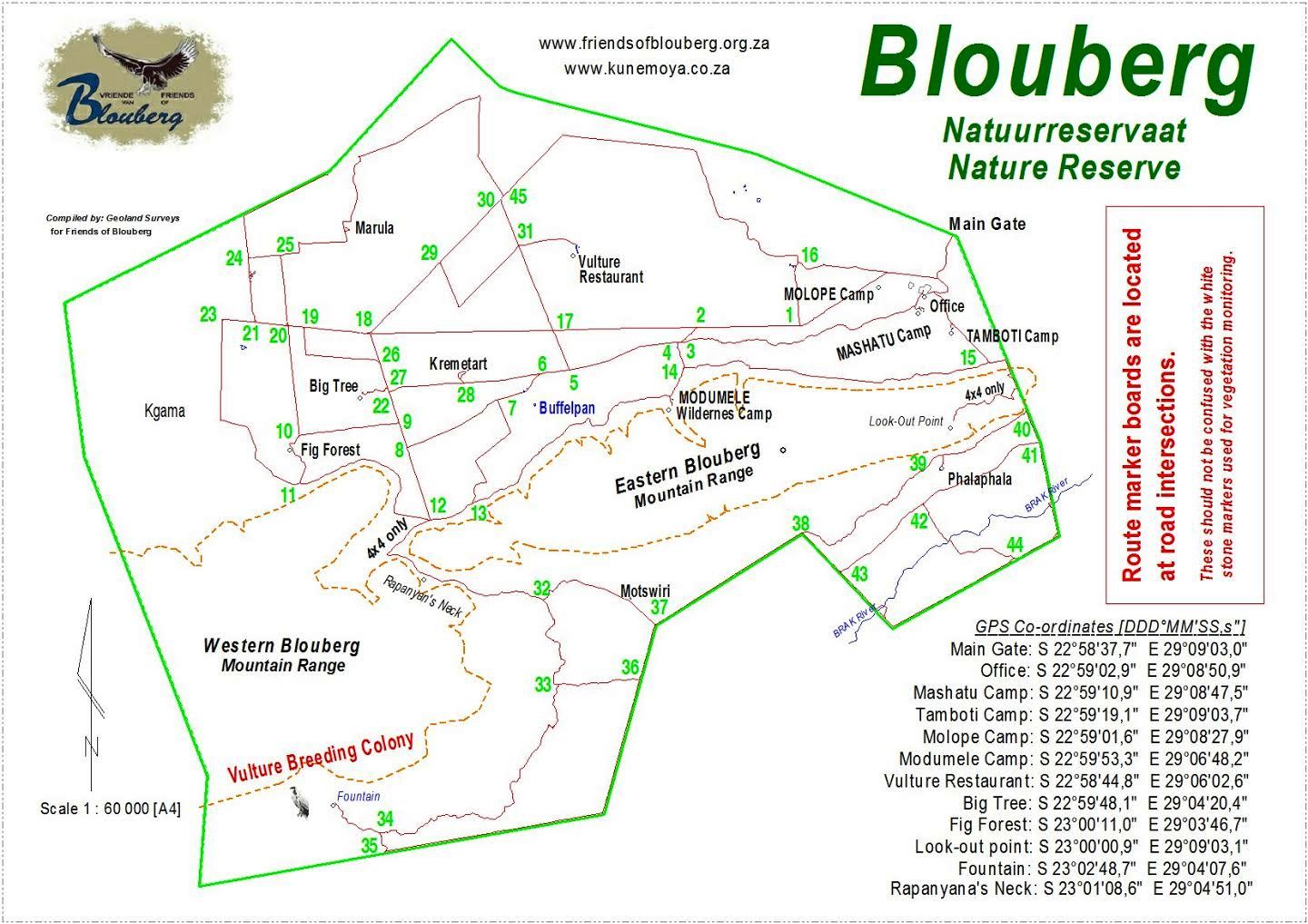
| Wikimedia Commons: Blouberg Nature Reserve map | commons.wikimedia.org | Open-licence map image | Reusable with attribution and share-alike, but not a GPX route |
External links
External links
| Source | URL |
|---|---|
| AllTrails — Blouberg | alltrails.com |
| Limpopo Wildlife Resorts — Blouberg Nature Reserve | lwr.gov.za |
| BirdLife South Africa — Blouberg Nature Reserve | gobirding.birdlife.org.za |
| Love Limpopo — Hike Blouberg | lovelimpopo.com |