Regional overview
The Eastern Cape Drakensberg is the high, sparsely populated southern sector of the Drakensberg / uKhahlamba-Maloti system around Rhodes, Barkly East, Wartrail, Lady Grey, Tiffindell and the Lesotho border. The walking character is remote highland rather than developed national-park trail network: farm tracks, jeep roads, sandstone valleys, basalt ridges, high passes, trout streams, rock-art shelters, open grassland and weather-exposed summit terrain.
Published trail data is uneven. Several locally important walks cross private farms or guest-farm land, and access may depend on booking, local permission, a guide, or current farm arrangements. Ben Macdhui is included because it is the region’s defining high point, but current access through Tiffindell is not verified as open and must not be treated as a normal public trail. Routes below are therefore labelled conservatively where official access, GPX files, or route-specific photographs remain unresolved.
Selection rationale
The five hikes were selected to represent the Eastern Cape Drakensberg’s main walking themes: one iconic high summit, one Rhodes high-country route, one Wartrail cultural/sandstone valley section, one Lady Grey / Witteberg point-to-point ridge route, and one short but steep peak objective. Naude’s Nek, Volunteershoek / Bidstone Pass and the Rhodes Marathon / SkyRun corridors are important regional context, but they were not selected as standalone day-hikes where a clearer hiking route or one-day section could be verified.
Summary table
| # | Hike | Country | Route type | Distance | Gain | Max elevation | Difficulty | Photo status |
|---|---|---|---|---|---|---|---|---|
| 1 | Ben Macdhui from Tiffindell / Ben MacDhui Pass | South Africa | Out-and-back candidate | 4.1 km route candidate; pass route 4x4 access unresolved | 211 m route candidate; pass ascent unresolved | 3001 m | Hard; access-restricted candidate | Open Tiffindell image verified |
| 2 | Gateshead Red Hut Trail, Rhodes | South Africa | Out-and-back | 9.0 km | 394 m | 2241 m | Moderate | Open Rhodes image verified |
| 3 | Wartrail Skywalk: Kernow to Glengariff section | South Africa | Point-to-point guided/private-land section | 15.0 km | Section max unresolved; full Skywalk reaches 2700 m | Easy-moderate | Regional highland image verified | |
| 4 | Lady Grey Wartrail | South Africa | Point-to-point | 8.7 km | 283 m | 2000 m | Moderate | Open Lady Grey / Joubert’s Pass image verified |
| 5 | Mount Newton Peak | South Africa | Out-and-back | 5.1 km | 566 m | 2402 m | Hard | Regional highland image verified |
1. Ben Macdhui from Tiffindell / Ben MacDhui Pass
Snapshot
Itinerary
The objective is the high ground above Tiffindell leading to Ben Macdhui, the 3001 m summit that defines the Eastern Cape Drakensberg high plateau. Mountain Passes South Africa describes Ben MacDhui Pass as an out-and-back route to the highest road summit in South Africa, involving the Tiffindell access road, the ski-lift maintenance track and a two-spoor jeep track near the summit. A Wikiloc community hiking listing for Ben McDhui gives a short 4.12 km / 211 m ascent candidate, but the exact trailhead and legal access conditions need direct local confirmation.
This entry must not be used as a go-now route description. Mountain Passes South Africa states that Tiffindell is closed and that access to Ben MacDhui Pass is not possible through that property. Any future publication needs written permission or an officially reopened access arrangement before a mapped hiking line is used.
Why it is essential
Ben Macdhui is the highest peak wholly in the Eastern Cape and the southernmost 3000 m summit in Africa according to common peak references. It is the natural high-point entry for the Eastern Cape Drakensberg catalogue, but it remains a publication candidate rather than an open route until access is legally confirmed.
Equipment
Full high-mountain day kit: waterproof shell, warm layers, hat and gloves even in summer, sun protection, navigation by map/GPS, spare battery, headlamp, food, emergency layer and enough water. Winter conditions can require snow/ice judgement and should not be treated as ordinary hiking.
Hazards and notes
Current access is the primary hazard: do not cross closed Tiffindell property or locked gates without permission. The route is high, windy and exposed, and weather can deteriorate quickly. Snow, ice, lightning, poor visibility and very limited rescue access are realistic concerns. Navigation should not rely on painted markers unless they have been locally confirmed.
Photos
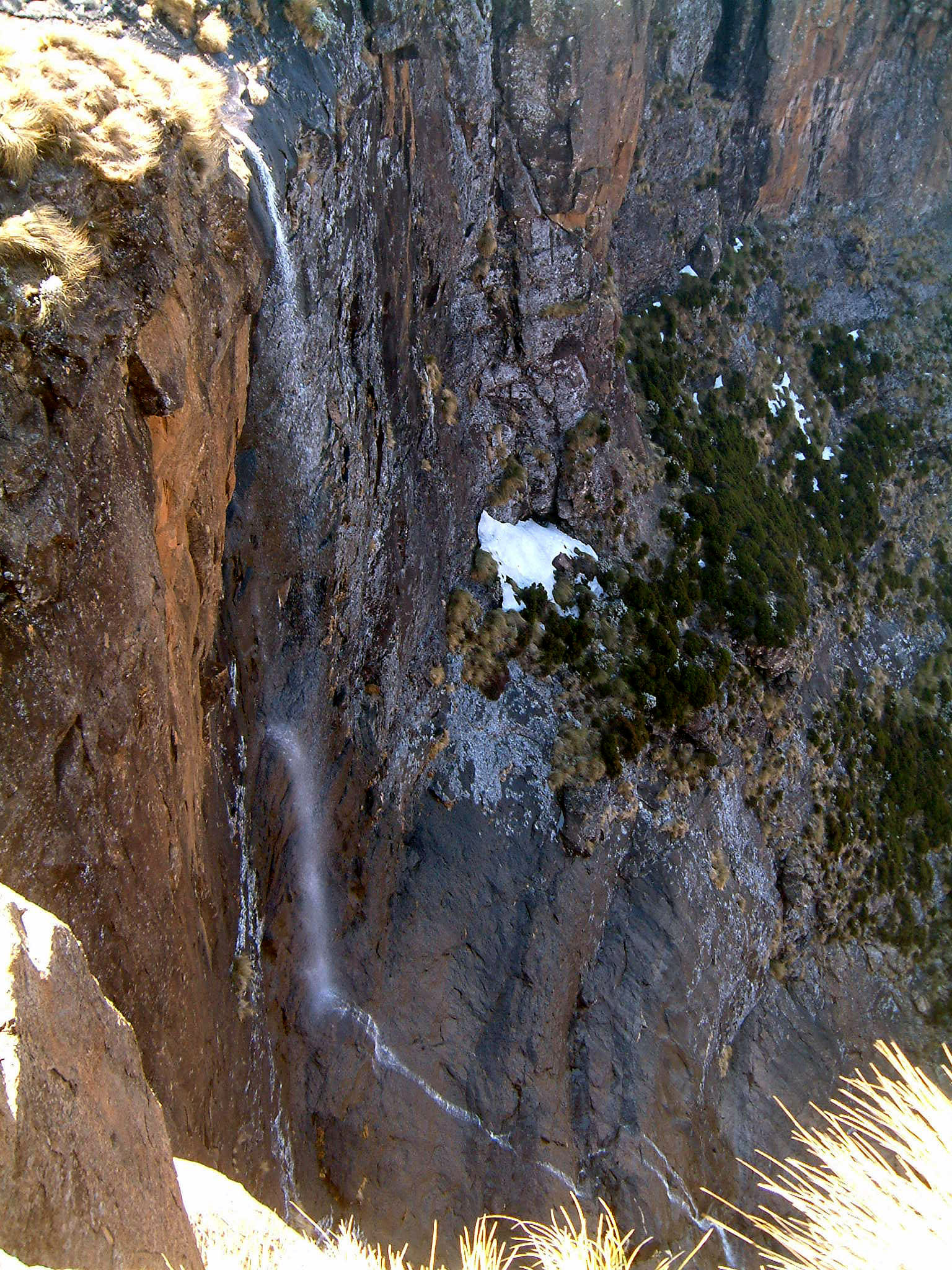
Photo status: One licence-compatible contextual image found for the Tiffindell / Ben Macdhui approach.
| Image / subject | Image URL | Source page URL | Author | Licence | Reuse notes | Attribution | Verification status |
|---|---|---|---|---|---|---|---|
| Tiffindell approach during summer | upload.wikimedia.org | commons.wikimedia.org | Hendrik van den Berg | CC BY 3.0 | Commercial reuse and modification allowed with attribution | Hendrik van den Berg, CC BY 3.0, via Wikimedia Commons | Verified |
GPX / KML links
| Source | URL | Format | Licence / terms | Reuse status |
|---|---|---|---|---|
| Wikiloc Telle Falls / Ben McDhui candidate listings | ca.wikiloc.com | Source map / GPX availability via Wikiloc | Wikiloc terms apply; account may be required; direct command-line retrieval was blocked by Cloudflare | Candidate only; no GPX downloaded in this pass |
| Mountain Passes South Africa: Ben MacDhui Pass | mountainpassessouthafrica.co.za | Source article; KMZ advertised for members | MPSA membership/terms; route crosses private property | Source confirms route context and closure warning; KMZ not retrieved |
External links
- Mountain Passes South Africa — Ben MacDhui Pass
- SA-Venues — Hiking Ben Macdhui
- Wikiloc — Telle Falls / Ben McDhui trail category
2. Gateshead Red Hut Trail, Rhodes
Snapshot
Itinerary
From the Rhodes high-country trailhead, the route heads out toward the Gateshead / Red Hut area and returns along the same line. AllTrails records the route as a 9.0 km moderately challenging out-and-back near Rhodes with 394 m of ascent and a maximum elevation just above 2240 m. The walk is representative of the open, grassy highlands above the Bell River village: broad views, exposed ridgelines and a remote farm-road feel rather than a built park path.
Before publication, the exact start point, parking permission and any farm-access requirements should be confirmed with Rhodes local information or the relevant landholder.
Why it is essential
Rhodes is one of the signature settlements of the Eastern Cape Drakensberg. This route gives a day-hike scale introduction to the high grassland above the village without using the much longer Rhodes Run or SkyRun routes.
Equipment
Sturdy footwear, windproof/waterproof layer, warm spare layer, sun hat, sunscreen, map/GPS, food and at least 1.5-2 litres of water. A headlamp is sensible because remote gravel-road access can add delays.
Hazards and notes
The route is exposed to wind, lightning and rapid temperature shifts. Trail marking, water reliability, parking and dog rules were not verified from an official source. Treat river or stream crossings as seasonal and check local conditions after storms.
Photos
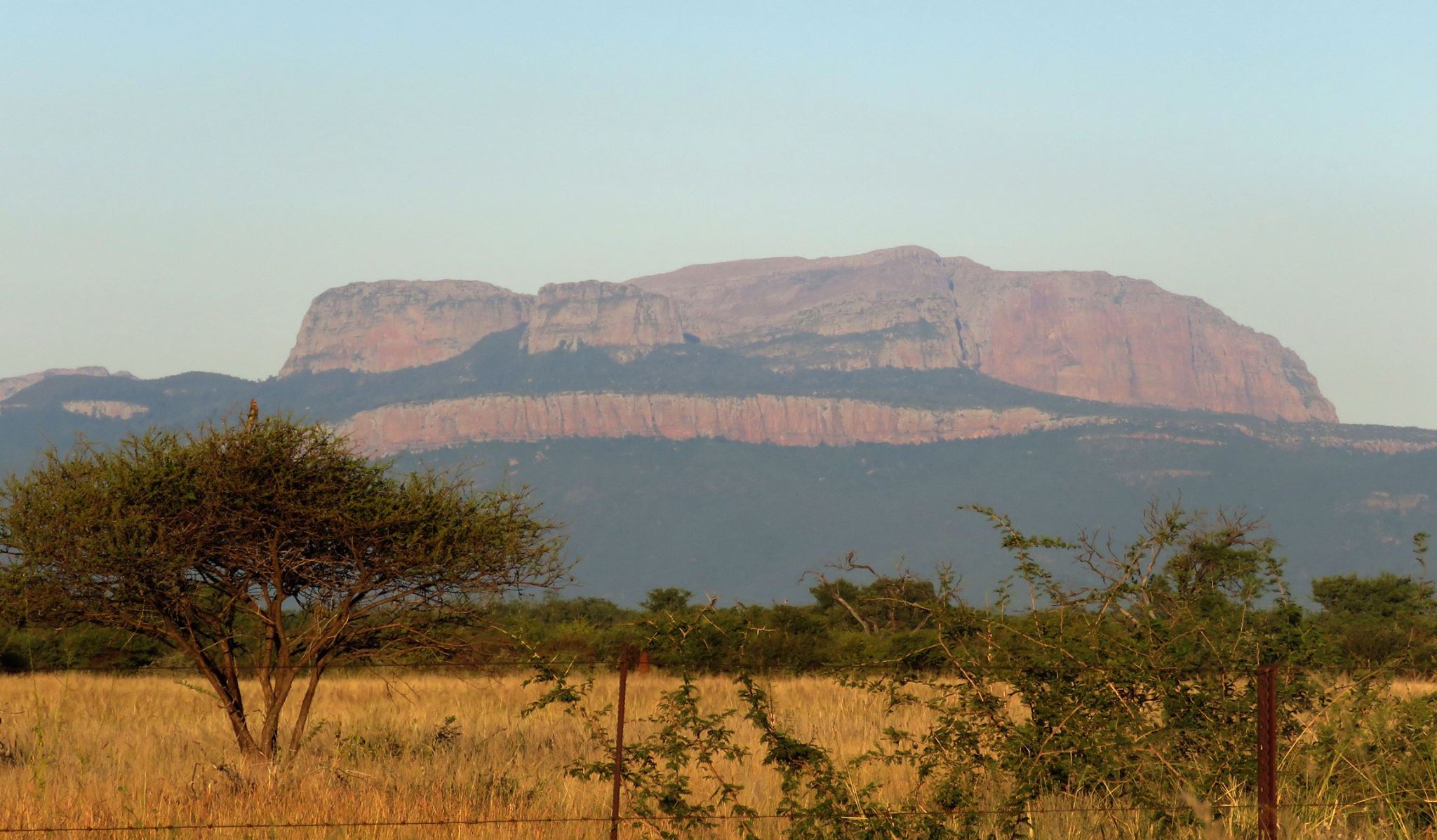
Photo status: One licence-compatible Rhodes contextual image found; no route-specific open image verified.
| Image / subject | Image URL | Source page URL | Author | Licence | Reuse notes | Attribution | Verification status |
|---|---|---|---|---|---|---|---|
| Village of Rhodes, South Africa | upload.wikimedia.org | commons.wikimedia.org | SA-Venues.com | CC BY 2.0 | Commercial reuse and modification allowed with attribution | SA-Venues.com, CC BY 2.0, via Wikimedia Commons | Verified |
GPX / KML links
| Source | URL | Format | Licence / terms | Reuse status |
|---|---|---|---|---|
| AllTrails: Gateshead Red Hut Trail | alltrails.com | Source map | AllTrails terms apply; direct GPX not retrieved | Source-map reference only; route statistics verified through AllTrails |
| OpenStreetMap search | openstreetmap.org | Map search | OSM data is ODbL | Geometry cross-check target only; no route relation selected |
External links
3. Wartrail Skywalk: Kernow to Glengariff section
Snapshot
Itinerary
This is the Day 3 section of the Wartrail Slackpacking Skywalk, selected as a one-day catalogue section rather than the full multi-day route. The Bidstone Cottages itinerary describes a 15 km walk from Kernow to Glengariff. It stops at a Boer War safe-house fort, drops into the Joggomspruit canyon, visits rock-art galleries, passes through Rannock Wood and finishes at the historic pink sandstone homestead of Glengariff Farm.
The route is not presented as a self-guided public trail. It crosses private farm country and should be arranged through the Skywalk operator or relevant farms.
Why it is essential
The Wartrail / New England area is one of the Eastern Cape Drakensberg’s strongest walking landscapes, combining sandstone valleys, basalt highlands, rock art, farm hospitality and bearded-vulture country. This section gives the catalogue a culturally important walking day rather than another summit-only route.
Equipment
Hiking boots, day pack, waterproof raincoat, warm fleece or wool layer, gloves, warm hat, sunscreen, sunglasses, water, headlamp, insect repellent, basic first-aid kit and walking poles if useful. Bidstone’s own kit list stresses warm clothing even in summer.
Hazards and notes
Private-land access, guide arrangements and transport logistics are integral to this route. Summer thunderstorms are common; the local operator advises early starts so walkers are down from higher ground after lunch. Cold, snow, wasp/bee allergies, knee/ankle strain and limited rescue access should be considered.
Photos
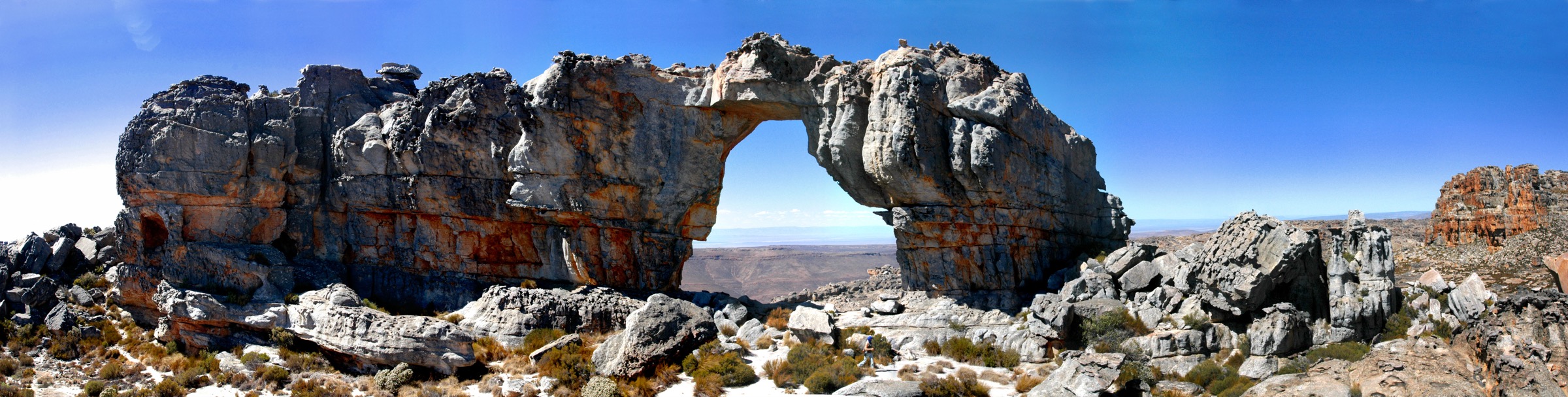
Photo status: One licence-compatible regional highland image found; no route-specific open image verified.
| Image / subject | Image URL | Source page URL | Author | Licence | Reuse notes | Attribution | Verification status |
|---|---|---|---|---|---|---|---|
| Sky Run 2011, Barkly East / Grassland National Park high country | upload.wikimedia.org | commons.wikimedia.org | Graham Maclachlan | CC BY-SA 3.0 | Commercial reuse and modification allowed with attribution and share-alike | Graham Maclachlan, CC BY-SA 3.0, via Wikimedia Commons | Verified |
GPX / KML links
| Source | URL | Format | Licence / terms | Reuse status |
|---|---|---|---|---|
| Bidstone Cottages: Wartrail Slackpacking Skywalk | bidstonecottages.co.za | Descriptive itinerary | Site copyright/terms not stated for route geometry | Route description only; no GPX/KML found |
| Wartrail & New England activities page | wartrail.co.za | Local area information | Site copyright/terms not stated for route geometry | Context only; no GPX/KML found |
External links
- Bidstone Cottages — Wartrail Slackpacking Skywalk
- Wartrail & New England — Active Outdoor Activities
4. Lady Grey Wartrail
Snapshot
Itinerary
AllTrails records Lady Grey Wartrail as an 8.7 km point-to-point route near Senqu NU, used for hiking and trail running. The line sits in the Lady Grey / Witteberg side of the Eastern Cape highlands, with river features noted and a maximum elevation of about 2000 m. Because it is point-to-point, the catalogue route requires a confirmed drop-off and pickup plan before publication.
The route should be paired with a local access check, especially around farm gates, parking, dogs and current trail marking.
Why it is essential
Lady Grey provides a different side of the Eastern Cape Drakensberg story: Witteberg ridges, high passes, small-town access and the eastern approach to the Wartrail / Barkly East highlands. It balances the Rhodes and Wartrail selections with a shorter ridge/valley day.
Equipment
Trail shoes or boots, sun protection, waterproof/windproof layer, warm spare layer, water, snacks, navigation, phone with offline map, and a prearranged pickup plan.
Hazards and notes
Point-to-point logistics are the main planning issue. Do not assume rideshare, taxis or phone signal will be available. Weather exposure, lightning, cattle/farm gates, river levels and possible route ambiguity need local checks.
Photos
Photo status: One licence-compatible contextual image found for Lady Grey / Joubert’s Pass.
| Image / subject | Image URL | Source page URL | Author | Licence | Reuse notes | Attribution | Verification status |
|---|---|---|---|---|---|---|---|
| View of Lady Grey from Joubert’s Pass | upload.wikimedia.org | commons.wikimedia.org | Utilisateur:Bel Adone | Public domain | Reuse and modification allowed; attribution not legally required where public-domain dedication is valid | Bel Adone, public domain, via Wikimedia Commons | Verified |
GPX / KML links
| Source | URL | Format | Licence / terms | Reuse status |
|---|---|---|---|---|
| AllTrails: Lady Grey Wartrail | alltrails.com | Source map | AllTrails terms apply; direct GPX not retrieved | Source-map reference only; route statistics verified through AllTrails |
| OpenStreetMap search | openstreetmap.org | Map search | OSM data is ODbL | Geometry cross-check target only; no route relation selected |
External links
5. Mount Newton Peak
Snapshot
Itinerary
The Mount Newton Peak route is a short, steep out-and-back near Senqu NU. AllTrails gives 5.1 km, 566 m of ascent and a maximum elevation of 2402 m, making it one of the most ascent-dense day-hikes in this Eastern Cape Drakensberg set. The route is included as the compact peak objective for fit walkers who want a strenuous half-day summit rather than a long farm-valley traverse.
Before publication, the exact start, parking permission and whether the route crosses private land need local verification.
Why it is essential
Mount Newton Peak adds a hard, view-focused summit option at a scale that still fits the day-hike catalogue. It complements Ben Macdhui by providing a currently mapped secondary peak route, while avoiding the closed-access problem around Tiffindell.
Equipment
Boots or grippy trail shoes, trekking poles if useful on steep ground, waterproof/windproof shell, warm spare layer, hat and gloves, sun protection, map/GPS, headlamp, food and water. A small emergency kit is recommended because the area is remote.
Hazards and notes
Expect steep slopes, exposure to wind and lightning, possible faint path sections and limited phone coverage. Snow, ice or saturated grass can make the descent significantly more difficult. Access/permission remains unresolved.
Photos
Photo status: One licence-compatible regional mountain-pass image found; no Mount Newton-specific open image verified.
| Image / subject | Image URL | Source page URL | Author | Licence | Reuse notes | Attribution | Verification status |
|---|---|---|---|---|---|---|---|
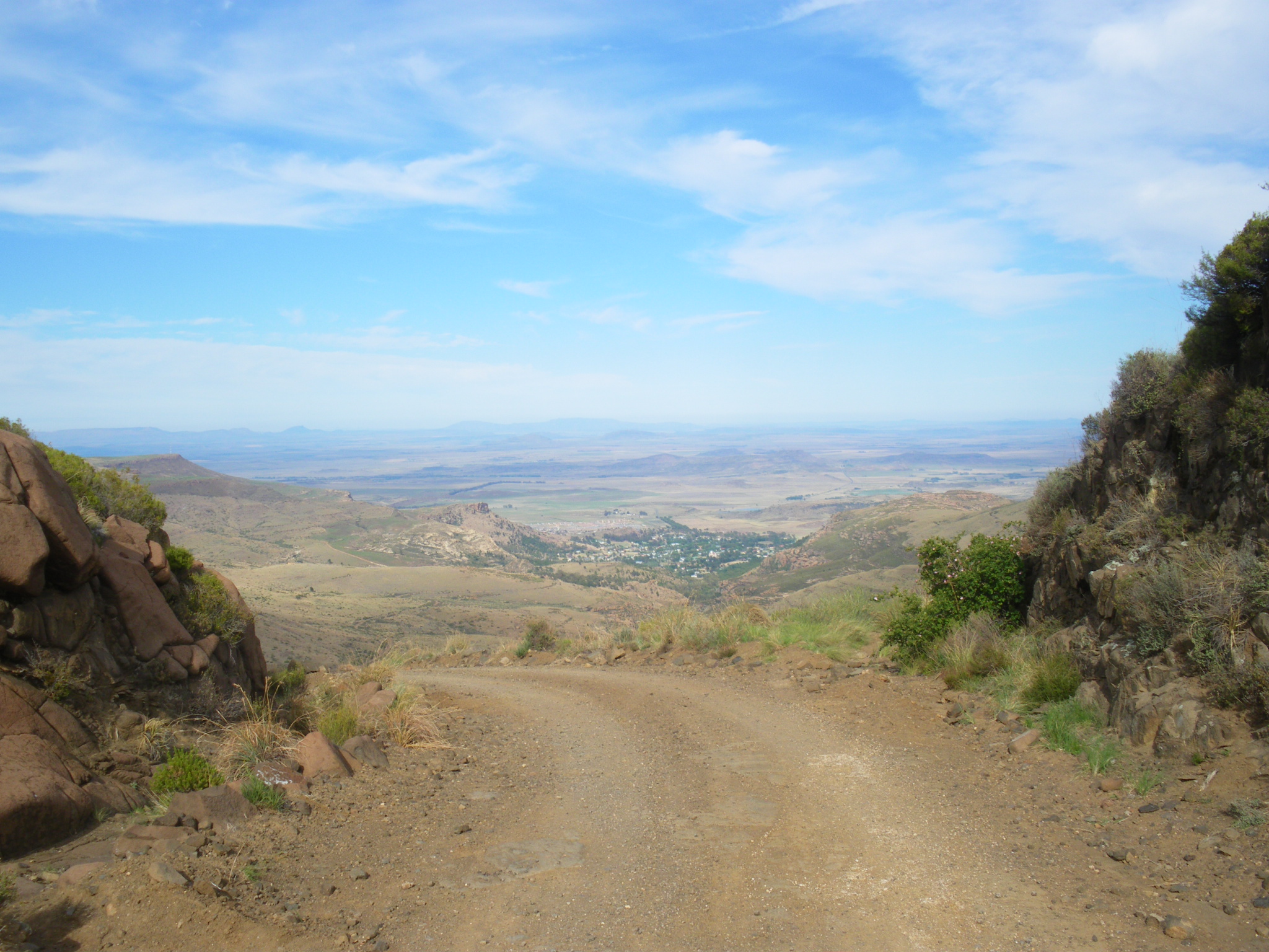
| Mountain pass near Rhodes, Eastern Cape highlands | upload.wikimedia.org | commons.wikimedia.org | Hendrik van den Berg | CC BY 3.0 | Commercial reuse and modification allowed with attribution | Hendrik van den Berg, CC BY 3.0, via Wikimedia Commons | Verified |
GPX / KML links
| Source | URL | Format | Licence / terms | Reuse status |
|---|---|---|---|---|
| AllTrails: Mount Newton Peak | alltrails.com | Source map | AllTrails terms apply; direct GPX not retrieved | Source-map reference only; route statistics verified through AllTrails |
| OpenStreetMap search | openstreetmap.org | Map search | OSM data is ODbL | Geometry cross-check target only; no route relation selected |
External links
Missing data and follow-up
- Confirm current legal access to Ben Macdhui in writing before publishing it as an open day-hike. If access remains closed, replace it with another verified highland route.
- Obtain exact trailhead coordinates and parking/access rules for Gateshead Red Hut, Lady Grey Wartrail and Mount Newton Peak.
- Confirm whether Wartrail Skywalk’s Kernow to Glengariff day can be booked or walked independently as a single-day route; current source supports it as part of the guided slackpacking itinerary.
- Retrieve GPX/KML files only where permitted by source access. AllTrails and Wikiloc source maps were identified, but direct GPX files were not downloaded in this pass.
- Find route-specific open images for Gateshead, Wartrail Skywalk and Mount Newton Peak; current images are contextual regional media.
External links
| Source | URL |
|---|---|
| Mountain Passes South Africa — Ben MacDhui Pass | mountainpassessouthafrica.co.za |
| SA-Venues — Hiking Ben Macdhui | sa-venues.com |
| AllTrails — Gateshead Red Hut Trail | alltrails.com |
| AllTrails — Lady Grey Wartrail | alltrails.com |
| AllTrails — Mount Newton Peak | alltrails.com |
| Bidstone Cottages — Wartrail Slackpacking Skywalk | bidstonecottages.co.za |
| Wartrail & New England — Active Outdoor Activities | wartrail.co.za |
| Rhodes Info Centre — Eastern Cape Highlands Camino | rhodesinfo.co.za |