Regional overview
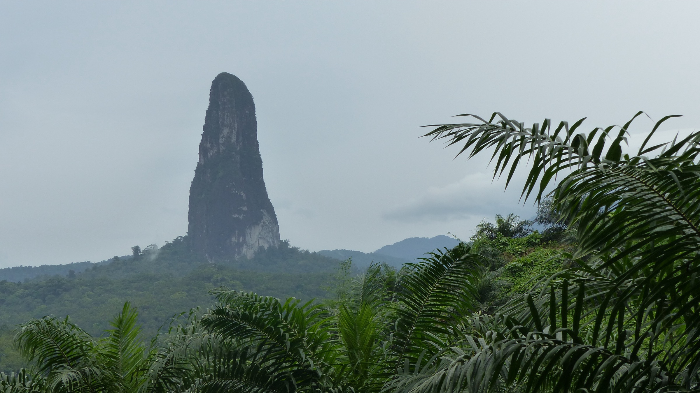
The São Tomé Highlands form the volcanic interior of São Tomé Island, the largest island of São Tomé and Príncipe and the central emerged peak of the southern Cameroon Volcanic Line. The highlands rise from a forested coastal plain to Pico de São Tomé at 2,024 m — the country’s high point — with a cluster of subsidiary summits, the eroded volcanic plug of Pico Cão Grande at about 663 m, and a high crater bowl now filled by a peat marsh known as Lagoa Amélia at around 1,500 m. Roughly 30 per cent of the country’s land surface, including most of the central mountains, sits inside Parque Natural Obô de São Tomé, the larger of the two protected areas that together form the Obô National Park system.
Walking on the island is concentrated around three nodes. The headquarters of the park at Bom Sucesso, on the road up from Trindade past the abandoned plantations of Monte Café, anchor the main interior hikes: the Lagoa Amélia rim walk, the long traverse to Bombaim, and the multi-day ascent of Pico de São Tomé. Monte Café and Saudade hold the cluster of waterfall and coffee-plantation walks, of which Cascata São Nicolau is the best known. The southern lowland forests around Porto Alegre and Agripalma’s palm-oil concession give access to the base of Pico Cão Grande. Príncipe’s separate highlands are covered in a sister article.
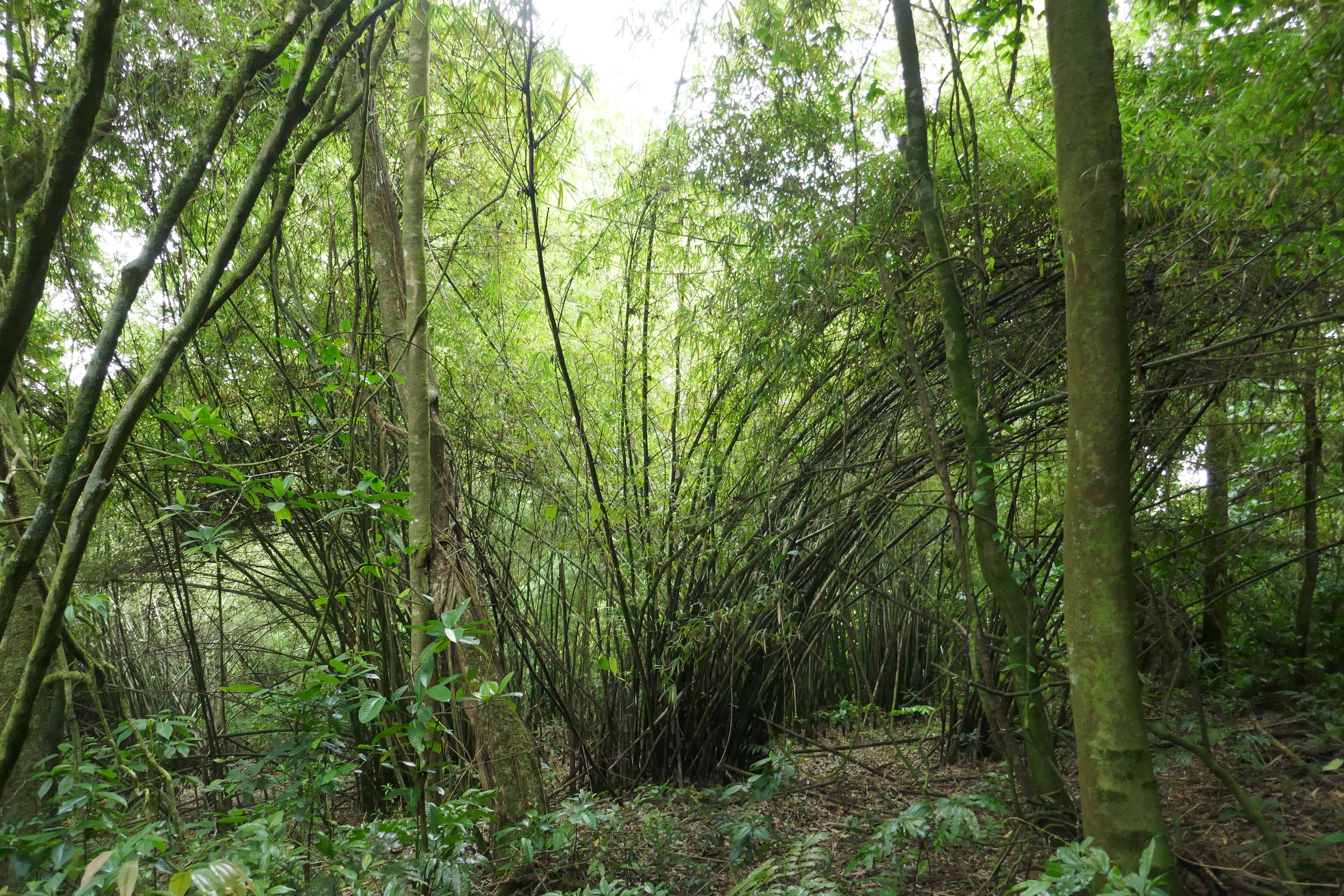
The walking character is humid Afromontane rainforest. Tracks climb from coastal plantations through closed-canopy primary forest into a mossy upper zone where tree ferns, begonias, and endemic Obô flora dominate. Most routes are short by alpine standards — 5 to 15 km — but heat, humidity, slippery clay tread, and root-laced descents make them feel considerably longer. The gravana dry season from June to September is the main hiking window. A secondary drier spell, the gravanito, opens in January and February. The two rainy periods — the long rains from March to May and shorter rains from October to December — leave tracks deeply muddy. The summit zone around Pico de São Tomé and Lagoa Amélia stays misted in almost every season.
A licensed Obô park guide is required on the interior trails, and the practical guide network is small. Bom Sucesso is the standard meeting point, and Mucumbli Explore, Navetur-Equatour, and a handful of locally based operators run most of the regular itineraries. Conservative wording is used throughout the page because much of the trail data depends on operator descriptions rather than mapped, waymarked public paths. Malaria is present year-round on São Tomé; standard chemoprophylaxis and bite avoidance are essential. Mobile signal is patchy or absent across most of the interior.
Selection rationale
The five hikes are chosen to cover the principal landforms and walking themes of the São Tomé Highlands: the summit of Pico de São Tomé as the high point of the Cameroon Line, the Lagoa Amélia crater as the headline easier walk inside the park, the Bom Sucesso to Bombaim ridge traverse as the classic point-to-point in the interior, the Cascata São Nicolau walk as the representative coffee-plantation waterfall route, and the Pico Cão Grande base approach as the iconic volcanic-plug viewpoint. Pico de São Tomé is normally guided as a two-day trek with an overnight at Mesa camp; it is framed here as a long single day from Bom Sucesso, which is feasible for fit and experienced parties but is not the standard format. Pico Cão Grande is included as a base-of-the-plug viewpoint walk, not as a technical climb, which is what the published ascent routes represent.
Summary table
| # | Hike | Country | Route type | Distance | Gain | Max elevation | Difficulty |
|---|---|---|---|---|---|---|---|
| 1 | Pico de São Tomé from Bom Sucesso | São Tomé and Príncipe | Out-and-back, long day or two-day | ~16-20 km | ~1,600 m | 2,024 m | Hard / strenuous |
| 2 | Lagoa Amélia rim walk from Bom Sucesso | São Tomé and Príncipe | Out-and-back | ~6-7 km | ~450 m | ~1,500 m | Moderate |
| 3 | Bom Sucesso to Bombaim ridge traverse | São Tomé and Príncipe | Point-to-point | ~9-10 km | ~450 m gain, ~1,100 m loss | ~1,500 m at the Lagoa Amélia rim | Hard |
| 4 | Cascata São Nicolau walk from Monte Café | São Tomé and Príncipe | Out-and-back | ~3-4 km | ~150 m | ~720 m | Easy to moderate |
| 5 | Pico Cão Grande base approach | São Tomé and Príncipe | Out-and-back | ~6-10 km | ~250-400 m | ~350 m at the viewpoint base | Moderate |
1. Pico de São Tomé from Bom Sucesso
Snapshot
Itinerary
The route starts at Bom Sucesso, the park headquarters at the end of the road past Roça Monte Café and Roça Saudade. The first section follows a fading colonial cobblestone track through abandoned plantation ground, then enters primary rainforest at about 1,300 m. The grade stiffens through a long forested middle section under closed canopy, with intermittent views toward the Anambó valley and the secondary cone of Calvário. Around 1,500 m a signed branch leaves the Bombaim corridor and climbs into the mossy upper-mountain zone of giant tree ferns, begonias, and endemic Obô forest.
The camp at Mesa do Pico, on a small flat shoulder at about 1,850 m, is where guided parties spend the night on the standard two-day format. From Mesa the final ridge to the summit takes 30 to 45 minutes on a narrow line with steep drops on either side and short scrambling moves between root and rock steps. The summit at 2,024 m is a small forested platform — views in clear weather reach the Atlantic on both sides of the island, but cloud is more common than not. Descent is on the same line and is harder underfoot than the climb. Fit and experienced parties have completed the round trip in a single 8 to 11 hour day from Bom Sucesso, but this is not the standard local format and accepts a higher margin for navigation, weather, and fatigue errors.
Why it is essential
Pico de São Tomé is the high point of São Tomé and Príncipe and the highest summit on the southern Cameroon Volcanic Line. The Bom Sucesso ascent is the headline interior hike of the country, climbs through the core of Obô National Park, and tops out on a mossy, forested summit ridge that is the defining mountain landscape of the highlands.
Equipment
- Light boots or trail-running shoes with strong grip on wet clay and root
- Waterproof shell and quick-dry layers; clear summit weather is the exception
- Warm layer for the camp and ridge — temperatures at Mesa can fall to single digits at night
- 3 L of water minimum per day; treatment for stream water at Mesa
- Head torch and spare batteries
- Trekking poles strongly recommended
- Tent or shelter if overnighting at Mesa (no built shelter)
- Licensed Obô park guide; standard logistics through Bom Sucesso
- Malaria chemoprophylaxis and bite protection
Hazards and notes
- Steep, root-laced clay tread that is slippery in almost every season.
- Persistent summit mist and limited visibility; navigation off the marked line is serious.
- River crossings are minor on this route but rise quickly after rain.
- Cold and wet bivouacs at Mesa even in the dry season.
- Single-day attempts compress fatigue and weather margins significantly — most guides will not run the route this way.
- Park guide and entry arrangements made at Bom Sucesso.
GPX / KML links
| Source | URL | Format / access | Reuse status |
|---|---|---|---|
| Wikiloc — Pico de São Tomé | wikiloc.com | Search page; user tracks | Wikiloc terms apply on selection; reuse unresolved |
| OpenStreetMap — Pico de São Tomé | openstreetmap.org | Source map / search | OSM data is ODbL; geometry cross-check only |
External links
- Wikipedia — Pico de São Tomé
- Wikipedia — Obô National Park
- Bradt Guides — Climbing the Pico de São Tomé
2. Lagoa Amélia rim walk from Bom Sucesso
Snapshot
Itinerary
From the botanical garden at Bom Sucesso the path leaves the park headquarters and climbs steadily through primary rainforest, passing under giant tree ferns, strangler figs, and endemic Obô forest flora. The first half hour gains height on a broad earth track. The path then narrows, crosses a couple of small drainage cuts, and reaches the rim of the Lagoa Amélia crater at around 1,500 m. The crater itself is a shallow bowl filled by a mossy peat-bog mat — there is no open water surface in normal years, but the floor is the source of several of the rivers that drain the central massif. A short rim path follows the eastern lip; operators do not normally descend onto the bog. Return is on the inbound line.
The route is one of the standard introductions to the Obô forest and to the endemic bird community of the highlands. São Tomé green pigeon, São Tomé oriole, São Tomé paradise flycatcher, Newton’s sunbird, and the São Tomé weaver are regularly recorded along the path.
Why it is essential
Lagoa Amélia is the most iconic feature of the central highlands after Pico de São Tomé itself and the easiest legal way to see the Afromontane primary forest. The rim walk is the headline accessible day in Obô National Park and the standard introduction for visitors who are not booked onto the summit trek.
Equipment
- Trail shoes or light boots with grip on wet clay
- Light rain layer
- 2 L water
- Insect repellent and long sleeves
- Binoculars for the endemic birds
- Licensed Obô park guide arranged at Bom Sucesso
- Malaria chemoprophylaxis
Hazards and notes
- Persistent humidity; afternoon rain showers are common.
- Slippery roots and clay sections, especially on the descent.
- Bog mat on the crater floor is unstable — operators normally keep parties on the rim.
- Mosquitoes; malaria present year-round.
- Park entry and guide arrangements made at Bom Sucesso.
GPX / KML links
| Source | URL | Format / access | Reuse status |
|---|---|---|---|
| AllTrails — Bom Sucesso Loop | alltrails.com | Route reference; GPX behind account | GPX reuse unresolved |
| Wikiloc — Lagoa Amélia | wikiloc.com | Search page; user tracks | Wikiloc terms apply on selection; reuse unresolved |
| OpenStreetMap — Lagoa Amélia | openstreetmap.org | Source map / search | OSM data is ODbL; geometry cross-check only |
External links
3. Bom Sucesso to Bombaim ridge traverse
Snapshot
Itinerary
The traverse leaves Bom Sucesso on the same path as the Lagoa Amélia walk, climbing through farmed lower ground and into the primary Obô forest. At around 1,500 m, just below the Lagoa Amélia rim, the corridor branches: the lagoon path goes right onto the rim, and the Bombaim path goes left along a long ridge that drops south-east into the upper Mussacavu and Mendes watersheds. The descent is the defining section of the day — sustained, steep, and slippery, with several short landslide-affected segments where the tread has been re-cut by guides and walkers. The path passes mossy boulder fields, small stream crossings, and the ruins of long-abandoned forest plantations swallowed by secondary growth.
The lower half eases as the path drops into the cultivated bowl around Roça Bombaim, an old cocoa estate established in the late 19th century at about 400 m on the upper Mendes river. The trail finishes at the roça itself, where guests are normally met by transport and where the Pousada Roça Bombaim is the standard rest point. Reversal — climbing from Bombaim to Bom Sucesso — adds significant gain and is not normally offered as a day hike by local operators.
Why it is essential
The Bom Sucesso to Bombaim corridor is the classic interior point-to-point of São Tomé and the only realistic day-long traverse across the central massif. It links the park headquarters, the Lagoa Amélia rim, the primary forest of Obô, and a working heritage cocoa plantation in a single day.
Equipment
- Light boots with strong tread; trail-running shoes are marginal on the descent
- Trekking poles for the long downhill
- Waterproof shell and quick-dry layers
- 3 L water
- Gaiters for the leeches that appear in the wetter months
- Insect repellent
- Licensed Obô park guide arranged at Bom Sucesso
- Malaria chemoprophylaxis
Hazards and notes
- Long, slippery descent — the single most common cause of incidents on this trail.
- Landslide-affected sections require careful footwork.
- Stream crossings rise quickly after rain.
- No water resupply between the upper rainforest and Bombaim.
- Pickup logistics from Bombaim need confirming before departure.
GPX / KML links
| Source | URL | Format / access | Reuse status |
|---|---|---|---|
| AllTrails — Bombaim to Bom Sucesso | alltrails.com | Route reference; GPX behind account | GPX reuse unresolved |
| Wikiloc — Bom Sucesso Bombaim | wikiloc.com | Search page; user tracks | Wikiloc terms apply on selection; reuse unresolved |
| OpenStreetMap — Bombaim | openstreetmap.org | Source map / search | OSM data is ODbL; geometry cross-check only |
External links
4. Cascata São Nicolau walk from Monte Café
Snapshot
Itinerary
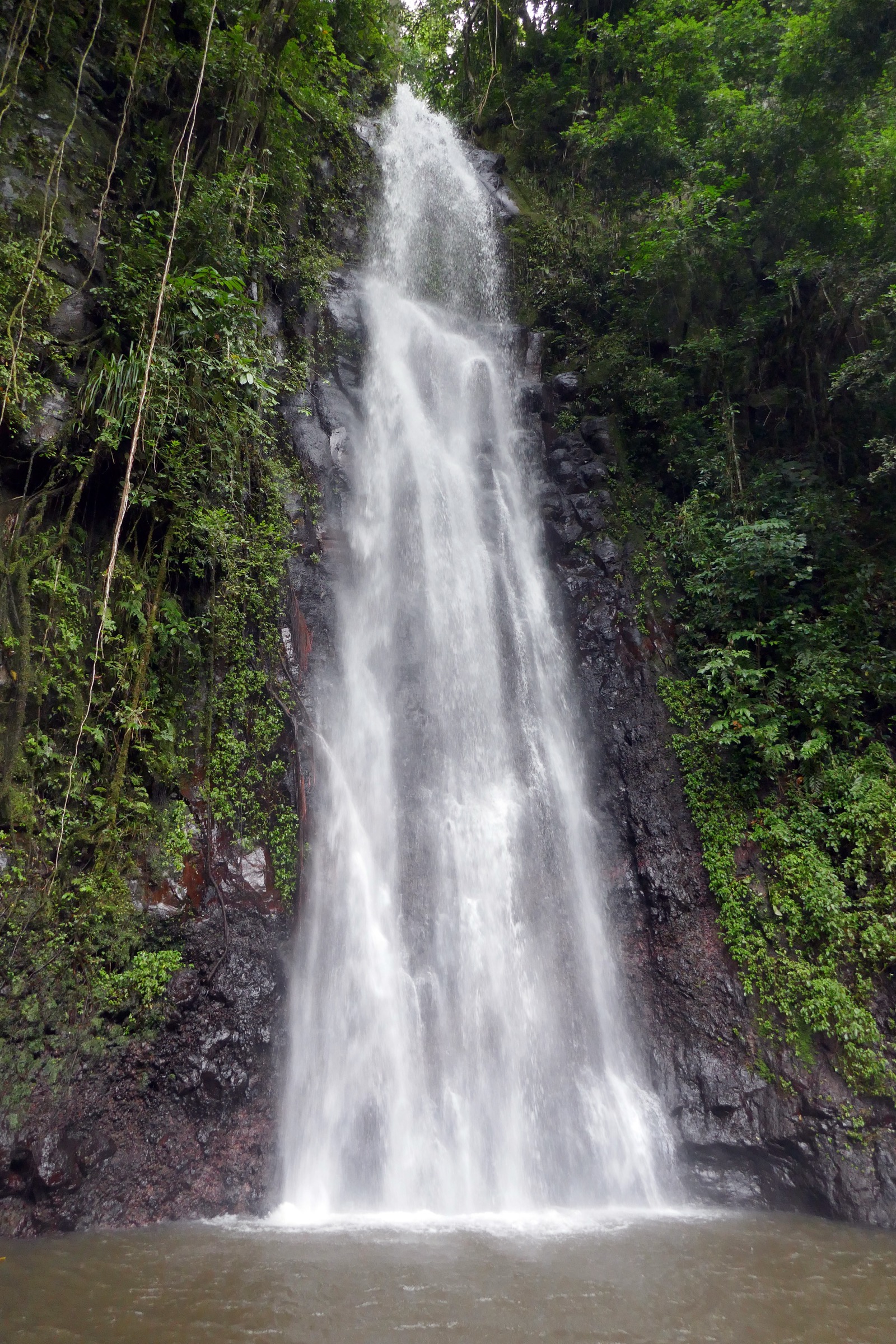
The walk leaves the Bom Sucesso road at the signed turning for Cascata São Nicolau, a short distance above Roça Monte Café. The first half is a wide vehicle-grade track that climbs steadily through working coffee plantation and patches of secondary forest, crossing several small bridges over feeder streams of the Abade and Mussacavu drainages. About halfway up the track contracts to a footpath that drops gently to the base of the falls through a small amphitheatre of basaltic boulders, hanging vines, and tree fern. The waterfall itself is reported at around 30 to 60 m by different sources; the lower pool is the standard turn-around. Wooden steps and a small footbridge cross the stream below the cascade. Return is on the inbound line.
Why it is essential
Cascata São Nicolau is the most accessible interior waterfall on São Tomé and the headline example of the coffee-plantation-and-waterfall walks that ring Monte Café and Saudade. It is the standard introduction to the central highlands for visitors who are not undertaking a full Obô itinerary, and it pairs naturally with a visit to the working coffee roça at Monte Café.
Equipment
- Trail shoes
- Sun protection on the lower plantation track
- 1-2 L water
- Swimwear for the lower pool
- Insect repellent
- Light rain layer
- Local guide recommended; arranged at Monte Café or in São Tomé city
Hazards and notes
- Slippery stone steps and wet rock at the base of the falls.
- Heavy spray near the plunge pool; slick footing.
- Tropical rain showers common in the afternoon, even in the dry season.
- Mosquitoes; malaria present year-round.
- The waterfall sits within the Obô protected area buffer; do not collect plants.
GPX / KML links
| Source | URL | Format / access | Reuse status |
|---|---|---|---|
| Wikiloc — Cascata São Nicolau | wikiloc.com | Route reference; user track | Wikiloc terms apply on selection; reuse unresolved |
| OpenStreetMap — Cascata São Nicolau | openstreetmap.org | Source map / search | OSM data is ODbL; geometry cross-check only |
External links
5. Pico Cão Grande base approach
Snapshot
Itinerary
The standard approach starts on the Agripalma access road south of Vila Clotilde, where the palm-oil concession holds the practical road head. Authorisation through the company administration is normally arranged in advance by the local guide. The walk leaves the processing unit on a graded plantation track that crosses a river and runs west into the lowland Obô forest. The track narrows to a footpath through closed canopy, with occasional gaps that open up the first views of the 300 m vertical plug rising sheer out of the forest. A short, steep final ramp brings walkers to a base viewpoint at the foot of the eastern face. The summit itself is a multi-pitch rock-climbing objective on phonolite — first ascended by a Japanese team in 1991, and re-climbed by several modern hard rock parties — and is not part of this walk.
The route is the closest legal viewpoint to one of the most recognisable volcanic landmarks in Africa and pairs naturally with a day trip down the south coast to Boca do Inferno, Praia Jalé, or the Roça São João dos Angolares.
Why it is essential
Pico Cão Grande is the iconic image of São Tomé and one of the most distinctive volcanic plugs in the world — a 300 m needle of phonolite rising out of pristine rainforest. The base approach is the established legal way to see it on foot. The summit climb is technical and outside the scope of this catalogue.
Equipment
- Trail shoes or light boots
- 2-3 L water
- Insect repellent and long sleeves
- Light rain layer
- Sun protection for the lower plantation section
- Local guide; Agripalma authorisation arranged in advance
- Malaria chemoprophylaxis
Hazards and notes
- Slippery roots and wet rock on the final ramp.
- River crossings rise quickly after rain.
- Snakes recorded in the lowland forest; rock at the base is moss-covered.
- Access depends on Agripalma’s operational schedule and on the local guide securing permission.
- Heat and humidity in the lowlands.
- The plug itself is not a hiker’s objective — established routes are graded F8a and harder.
GPX / KML links
| Source | URL | Format / access | Reuse status |
|---|---|---|---|
| Wikiloc — Pico Cão Grande | wikiloc.com | Search page; user tracks | Wikiloc terms apply on selection; reuse unresolved |
| OpenStreetMap — Pico Cão Grande | openstreetmap.org | Source map / search | OSM data is ODbL; geometry cross-check only |
External links
- Wikipedia — Pico Cão Grande
- Wikipedia — Obô National Park
- Planetmountain — Pico Cão Grande climbing notes
Missing data / follow-up work
- No officially published GPX/KML downloads were located for any of the five routes. AllTrails, Wikiloc, and OpenStreetMap are used as geometry references only; field-collected GPS tracks are still needed to firm up distances and ascents.
- Distance and elevation figures for Pico de São Tomé, Lagoa Amélia, and the Bombaim traverse vary noticeably between operators; the figures above are best-available approximations from a mix of operator pages and trail-database summaries.
- The standard Pico de São Tomé itinerary is a two-day trek with an overnight at Mesa camp; the single-day Bom Sucesso ascent is feasible for fit and experienced parties but is not the local guided default. Cross-check current operator practice before booking a day attempt.
- Exact height of Cascata São Nicolau is variously reported between roughly 30 m and 60 m across sources; field measurement is needed.
- Pico Cão Grande base-walk distance varies sharply between sources — 4 km one-way from a Guadalupe-side estimate and 10 km return from operator pages — and depends on which Agripalma road head is used. The route also depends on company permission, which is not a formal permit.
- Park-entry fees, guide rates, and Agripalma access arrangements change frequently; confirm current rates at Bom Sucesso and through your operator before travel.
- Public transport schedules between São Tomé city, Trindade, Monte Café, Bom Sucesso, and the south coast are informal; shared-taxi timings are not published.
- A licence-compatible photograph showing the summit ridge of Pico de São Tomé itself at the required resolution was not located in this pass; the Pico Cão Grande cover stands in as the regionally representative image and a dedicated summit photograph is still pending.