Regional overview
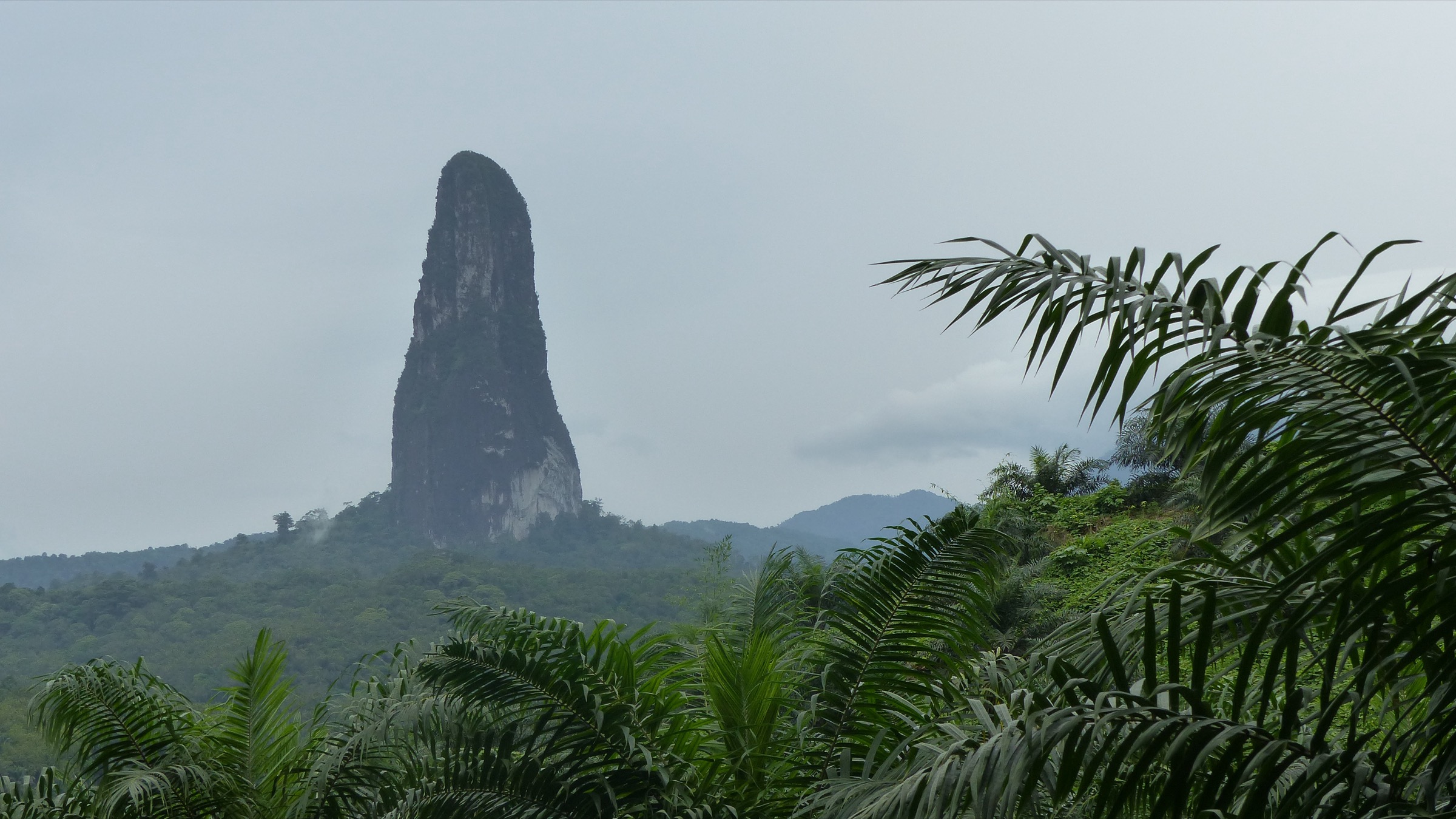
Príncipe is the smaller of the two main islands of São Tomé and Príncipe, sitting in the Gulf of Guinea as the northernmost emerged peak of the Cameroon Line volcanic chain. The island is dominated by eroded volcanic plugs and steep forested ridges rising from the coast to Pico de Príncipe at 948 m, with the dramatic horn of Pico Papagaio at 680 m forming the most recognisable landmark behind the capital Santo António.
Roughly half of the island sits inside Parque Natural do Obô do Príncipe, the core of the Island of Príncipe UNESCO Biosphere Reserve declared in 2012. Most established walking routes leave from coastal roças (former plantations such as Sundy, Belo Monte, Paciência, and Infante) and climb into submontane and Afromontane cloud forest. Park rules require a licensed guide for interior trails, and several core-zone summits — including Pico de Príncipe itself — are not currently offered as casual visitor routes.
The best walking window is the gravana dry season from June to September, when humidity drops, leeches are less active, and views from the volcanic plugs open up. Even in the dry season, rainforest tracks are slippery, river crossings are common, and the only realistic logistics base for most visitors is the HBD-affiliated Príncipe Collection of lodges (Sundy Praia, Roça Sundy, Bom Bom). Conservative wording is used throughout because much of the trail data depends on operator itineraries rather than mapped, waymarked public paths.
Selection rationale
The five hikes were selected to balance the island’s three documented walking themes: the iconic volcanic summit, the rainforest waterfall, and the heritage-roça forest landscape. Pico Papagaio is the only summit hike with consistently published route statistics. Oquê Pipi is the standard waterfall objective. Ribeira Izé and Roça Infante represent the cultural-historical strand. The Belo Monte to Praia Banana descent provides a coastal/heritage traverse that ends on one of the island’s signature beaches. Pico de Príncipe itself is flagged in the follow-up notes because access for casual visitors could not be confirmed.
Summary table
| # | Hike | Route type | Distance | Gain | Max elevation | Difficulty |
|---|---|---|---|---|---|---|
| 1 | Pico Papagaio summit from Santa Trindade | Out-and-back | About 14 km on Wikiloc source | About 410 m on Wikiloc source | 680 m at summit | Hard; fixed ropes on final scramble |
| 2 | Oquê Pipi waterfall trail | Out-and-back, multiple variants | 2.3-6.3 km depending on variant | 76-180 m depending on variant | About 280 m above trailhead per Wikiloc | Easy-moderate |
| 3 | Ribeira Izé ruins trail from Praia Sundy | Out-and-back coastal/forest | Unresolved; about 3-5 km estimated | Minimal | Below 100 m | Easy-moderate |
| 4 | Roça Infante interior loop | Loop or out-and-back, guided | Unresolved; full-day | Unresolved | Unresolved | Moderate-hard rainforest |
| 5 | Belo Monte to Praia Banana descent | Point-to-point | About 4-5 km on Wikiloc source | Net descent of about 200-300 m | Belo Monte plateau | Easy-moderate |
Before you go
Required equipment
- Trail-running shoes or light hiking boots with strong grip; the volcanic soil is muddy and slippery for most of the year.
- Long sleeves and trousers for forest sections, insect repellent, and leech protection during and after the rainy months.
- Rain shell and quick-dry layers — clear weather is the exception, not the rule.
- Two to three litres of water minimum, food, electrolytes, dry-bag for camera and phone.
- Head torch, basic first-aid kit, and a backup map or offline GPS — phone signal disappears quickly in the interior.
- Light rope handling experience and gloves for the fixed-rope sections on Pico Papagaio.
Current access and safety notes
- Almost all interior trails require a licensed Obô park guide; the Príncipe Collection lodges and Santo António-based guide associations are the standard providers.
- Pico de Príncipe (948 m) sits inside the strict-protection core zone of the park and was not confirmed as a routine visitor objective at the time of writing.
- Tropical heat, humidity, and persistent mud create slip and ankle-roll hazards even on short walks.
- Rivers can rise quickly after rain; do not attempt crossings during or immediately after storms.
- Malaria is present year-round; standard chemoprophylaxis and bite avoidance are essential.
- Boat-supported beach drop-offs and pickups along the south and west coasts depend on sea state; build slack into the day.
1. Pico Papagaio summit from Santa Trindade

Snapshot
Itinerary
The route begins at Santa Trindade, on the southern edge of Santo António, where a forest track leaves the road and climbs steadily through secondary forest and old plantation ground. Within the first hour the trail enters primary submontane forest and the gradient stiffens. The middle section is a sustained, root-laced climb under closed canopy, with occasional gaps opening east toward Pico Mencorne and São Joaquim.
The final 100-150 m of ascent is the defining section of the route. The trail tightens onto the volcanic plug, the soil thins, and the path uses fixed ropes installed by local guides to negotiate near-vertical rock and root steps. The summit cone is small but gives a 360-degree view across northern Príncipe — the spires of the Mencorne ridge to the south, the cocoa flats of Roça Belo Monte to the east, and Bom Bom and the coast to the north. Descent is by the same line, with the rope sections more demanding on tired legs.
Why it is essential
Pico Papagaio is the signature peak of Príncipe and the only commonly offered summit hike on the island. It combines the country’s most recognisable volcanic skyline, a real climb with fixed-rope movement, and a summit view that captures most of the Highlands in a single panorama.
Equipment
Sticky-rubber trail shoes or light boots, gloves for the rope sections, two to three litres of water, snacks, insect repellent, and a head torch as a margin against late descent. Long sleeves and trousers protect against vegetation and biting insects.
Hazards and notes
- Fixed-rope movement on steep rock and root steps near the summit; not suitable for those uncomfortable with exposed scrambling.
- Slippery rainforest mud throughout the climb; descent injuries are the main concern.
- Park rules require a licensed Obô guide; do not attempt unaccompanied.
- Afternoon storms are common; an early start and a hard turnaround time are recommended.
GPX / KML links
| Source | URL | Format / access | Reuse status |
|---|---|---|---|
| Wikiloc — Pico Papagaio, Ilha do Príncipe | wikiloc.com | Source route page / GPX via Wikiloc | Stats verified from source page; route-file reuse not confirmed under Wikiloc terms |
| Wikiloc — São Joaquim to Pico Príncipe loop | wikiloc.com | Source route page | Cross-reference candidate; route-file reuse not confirmed |
External links
- Wikipedia — Pico do Príncipe
- Wikipedia — Parque Natural Obô do Príncipe
- Wikiloc — Pico Papagaio source track
2. Oquê Pipi waterfall trail

Snapshot
Itinerary
The trail leaves a plantation-edge access point — typically near Roça Lucindo or the Barracão side of the central forest — and follows a forest track through old bamboo plantation, secondary rainforest, and short stream crossings. The path gains height steadily and the canopy closes over completely, with the air noticeably cooler than the coast.
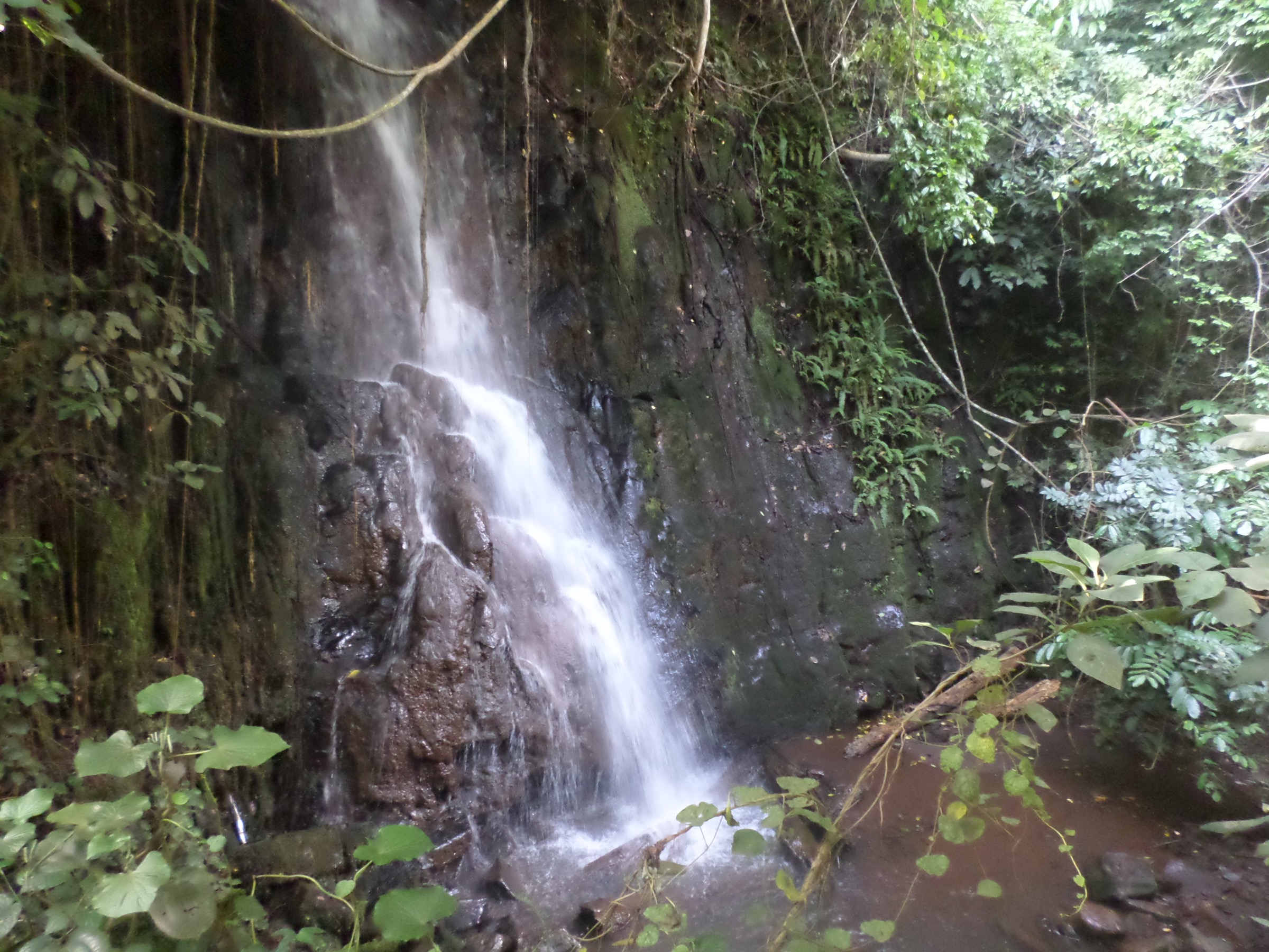
The waterfall itself is a vertical drop of around 30 m into a deep, clear pool surrounded by mossy basalt walls and fern-covered slopes. Most visitors swim or rest at the pool before retracing the route. The longer biosphere-trail variant extends the day with a forest loop that traverses higher ground before rejoining the main line back to the trailhead.
Why it is essential
Oquê Pipi is the most accessible rainforest waterfall on Príncipe and the standard short walk for visitors who want to experience the Obô interior without committing to a peak day. The pool itself is the visual centrepiece, and the variants give some flexibility on length and difficulty.
Equipment
Trail shoes with grip, swimwear and a quick-dry towel, two litres of water, snacks, insect repellent, and a dry-bag for electronics.
Hazards and notes
- Slippery roots, mud, and stream stones throughout; descent after rain is the main injury risk.
- Pool depth varies; check entry conditions and do not jump from rocks of unknown depth.
- Trail signs are not consistent across variants; a guide is required in any case under park rules.
- Leeches are present in the wetter months.
GPX / KML links
| Source | URL | Format / access | Reuse status |
|---|---|---|---|
| Wikiloc — Cascata Oquê Pipi | wikiloc.com | Source route page / GPX via Wikiloc | Stats verified from source page; route-file reuse not confirmed |
| Wikiloc — Roça Lucindo to Oquê Pipi variant | wikiloc.com | Source route page / GPX via Wikiloc | Stats verified; reuse not confirmed |
| Wikiloc — Biosphere Trail 7, Cascata Oquê Pipi | wikiloc.com | Source route page / GPX via Wikiloc | Short variant; reuse not confirmed |
External links
3. Ribeira Izé ruins trail from Praia Sundy

Snapshot
Itinerary
The route leaves Praia Sundy at the northern end of the Sundy peninsula and follows coastal forest paths and short beach sections south-west toward the ruins of Ribeira Izé, the site of one of the earliest Portuguese settlements on Príncipe. The walk passes through dense jungle with strong endemic-bird activity, crosses small streams, and emerges at the abandoned settlement.
The centrepiece of the ruins is the remains of an early church, partly held together by the roots of large ceiba trees that have grown through the walls. Most operators continue a short distance further to Praia Mocotó for swimming before returning by the same path; a longer extension links the trail onward to Bom Bom.
Why it is essential
Ribeira Izé combines colonial archaeology with rainforest-to-coast walking and is one of the few short hikes on the island that does not depend on heavy ascent. It is a good acclimatisation day before harder objectives such as Pico Papagaio.
Equipment
Light trail shoes that drain well, swimwear, sun protection, one to two litres of water, insect repellent, and a dry-bag for electronics on the beach sections.
Hazards and notes
- Wet roots and slippery rock on the jungle/coast transitions; short slippery scrambles can occur.
- Tides and sea state affect the beach and rock-platform sections; check timing with the guide.
- A licensed guide is required inside the Obô park boundary.
GPX / KML links
| Source | URL | Format / access | Reuse status |
|---|---|---|---|
| OpenStreetMap search — Ribeira Izé Príncipe | openstreetmap.org | Map data / search | OSM data is ODbL; candidate geometry check only |
| Wikiloc — Príncipe hiking trail list | wikiloc.com | Trail listing | Operator and crowd-sourced tracks may apply |
External links
4. Roça Infante interior loop

Snapshot
Itinerary
The route starts on the inland edge of the Periquito area and follows old plantation paths south through dense primary and secondary rainforest into one of the least-visited corners of the island. The terrain undulates over forested ridges, crosses small streams, and reaches the abandoned coffee/cocoa estate of Roça Infante, where the forest has retaken the main buildings and the small port. Most parties return by the same line; some operators offer a longer loop through a parallel valley.
Why it is essential
Roça Infante is the deepest commonly-offered walk into the southern Obô interior. It combines rainforest density, colonial-roça archaeology, and the chance to see endemic species such as the Príncipe thrush, Príncipe sunbird, and Príncipe golden weaver away from the busier northern circuits.
Equipment
Sturdy trail shoes or light boots, long sleeves and trousers, two to three litres of water, insect repellent, leech protection, head torch as a margin for late returns, and a dry-bag for camera and phone.
Hazards and notes
- Long day in humid forest; hydration and pace management are the main concerns.
- Stream crossings can rise quickly after rain.
- Trail use varies seasonally; route may need machete clearance and a guide is essential.
- Remote location with limited rescue infrastructure.
GPX / KML links
| Source | URL | Format / access | Reuse status |
|---|---|---|---|
| Wikiloc — Roça Infante Henrique | wikiloc.com | Source route page / GPX via Wikiloc | Stats partially verified; reuse not confirmed |
| Príncipe Collection — Roça Infante Trail | principecollection.com | Operator itinerary | Operator content; no reusable route file |
External links
5. Belo Monte to Praia Banana descent

Snapshot
Itinerary
The route leaves Roça Belo Monte on the cocoa plantation tracks above the Sundy Praia hotel and descends through old plantation rows, secondary rainforest, and a string of small streams toward the north-east coast. Roça Paciência appears in the middle section, where the forest opens onto a former plantation court still surrounded by old buildings.
Below Roça Paciência the path drops through dense vegetation and short clearings, with Pico Papagaio sometimes visible to the south on clear days. The route then descends to Praia Grande and continues along the headland to the crescent of Praia Banana, one of the most photographed beaches in the country. Most parties exit by boat or by waiting vehicle from the Praia Banana access track.
Why it is essential
The Belo Monte traverse is the standard heritage-and-coast day on Príncipe, combining a plateau plantation, a forest descent, and one of the island’s signature beaches. It is the most balanced moderate option in the catalogue, suitable for less experienced walkers and for guests who want a single highlights day.
Equipment
Trail shoes that drain, swimwear and quick-dry towel, sun protection, one to two litres of water, insect repellent, and a dry-bag.
Hazards and notes
- Slippery ground after rain on the plantation and forest sections.
- Sun exposure on the final beach approach.
- Boat or vehicle pickup from Praia Banana depends on sea/road conditions; confirm logistics before starting.
- Park-edge sections still require a guide.
GPX / KML links
| Source | URL | Format / access | Reuse status |
|---|---|---|---|
| Wikiloc — Belo Monte to Praia Banana via Roça Paciência and Praia Grande | wikiloc.com | Source route page / GPX via Wikiloc | Stats partially verified; reuse not confirmed |
External links
Missing data and follow-up work
- Pico de Príncipe (948 m) — listed in core-zone strict-protection material and not confirmed as a routine guided objective. Direct contact with the park authority and HBD/Príncipe Collection lodges is needed.
- Elevation profiles — gain/loss figures for Ribeira Izé, Roça Infante, and parts of the Belo Monte traverse depend on operator estimates rather than mapped Wikiloc tracks.
- Licence-compatible peak photography — no high-resolution (≥2,400 px) CC-licensed photograph of Pico Papagaio or Pico de Príncipe was found in this pass. The cover image is a Praia Sundy beach view from the Wiki Loves Earth 2016 batch.
- Operator timetables — Príncipe Collection itineraries and boat-pickup schedules change seasonally and should be confirmed before publication.
- Maria Correia waterfall and Mencorne ridge — both appear in tourism material but lack public route data and were excluded from this pass.
External links
| Source | URL |
|---|---|
| Wikipedia — Pico do Príncipe | en.wikipedia.org |
| Wikipedia — Parque Natural Obô do Príncipe | en.wikipedia.org |
| Wikipedia — Island of Príncipe Biosphere Reserve | en.wikipedia.org |
| Wikipedia — Príncipe | en.wikipedia.org |
| Príncipe Collection — Experiences | principecollection.com |
| HBD Príncipe — Experiences | hbdprincipe.com |
| Wikiloc — Príncipe hiking trail list | wikiloc.com |
| Komoot — Hiking in São Tomé and Príncipe | komoot.com |