Regional overview
The Western and Basque Pyrenees form the Atlantic end of the range: green ridges, steep pastoral hills, humid beech woods, limestone gorges, karst plateaux, and the first high summits above 2,000 m. Hiking centres include the French Basque Country around Ascain, Larrau and Sainte-Engrâce, then the Béarn valleys around Ossau, Barétous and Lescun.
The walking character changes quickly from low, grassy Atlantic hills to serious limestone terrain. Lower routes such as La Rhune can be walked for much of the year in good conditions, while high routes such as Pic d’Anie and the Lacs d’Ayous are normally summer-to-autumn objectives once snow has cleared.
Weather is a major factor. Atlantic cloud can make ridges and karst areas difficult to navigate, and wet rock or mud can make steep Basque paths more serious. In the Parc national des Pyrénées core area, restrictions apply: dogs are not admitted even on a lead, drones and fires are prohibited, and bivouac rules are limited.
Selection rationale
These five hikes give a balanced cross-section of the region: an iconic Basque summit, the first major western 2,000 m peak, a dramatic gorge-and-footbridge circuit, the classic Ossau lake circuit, and a high limestone summit above Lescun and La Pierre Saint-Martin. Chemin de la Mâture was not selected because current official tourism information warns of a dangerous collapse and recommends avoiding the affected sector.
Summary table
| # | Hike | Country | Route type | Distance | Gain | Max elevation | Difficulty | Photos |
|---|---|---|---|---|---|---|---|---|
| 1 | La Rhune / Larrun via Miramar | France | Loop | 13.2–13.8 km | +876–898 m | 905 m | Difficult | Commons CC BY-SA found |
| 2 | Pic d’Orhy / Orhi from Port de Larrau | France / Spain border | Out-and-back | 2.6–5 km depending on measurement | +433–500 m | 2,017 m | Medium–difficult | Commons CC BY-SA found |
| 3 | Olhadübi and Passerelle d’Holzarte loop | France | Loop | 13.5–13.6 km | +690–750 m | 988 m | Difficult | Commons CC BY-SA found |
| 4 | Tour des Lacs d’Ayous | France | Loop | 14.2–14.3 km | +720 m | 2,095 m | Difficult | Commons CC BY-SA found |
| 5 | Pic d’Anie / Auñamendi from La Pierre Saint-Martin | France / Spain border | Out-and-back | 13.5–17 km depending on variant | +1,017–1,100 m | 2,504 m | Difficult | Commons CC BY-SA found |
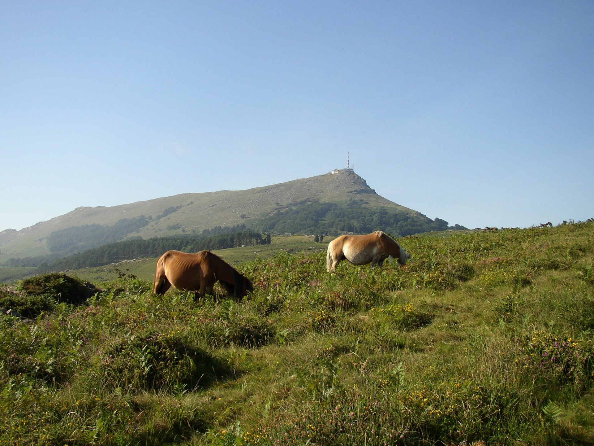
1. La Rhune / Larrun via Miramar
Snapshot
Itinerary
The route starts at the Parking des Carrières near Ascain and climbs towards Trois Fontaines before entering open slopes and the Ihizelai / Miramar plateau. It then continues towards Col d’Errepausu and the summit of La Rhune / Larrun at 905 m. The descent follows a different line back towards Ascain, with the official itinerary warning against cutting switchbacks on the descent.
Why it is essential
La Rhune is one of the defining summits of the Basque Pyrenees. The official route description calls it an “incontournable” hike, with summit views extending from the Landes beaches to the first Pyrenean summits.
Equipment
- Sturdy hiking footwear
- Weatherproof layer
- Warm layer
- Water and food
- Map or GPS
- Sun protection
- Trekking poles recommended for the descent
Hazards and notes
- Significant ascent for its altitude.
- Steep and rocky sections.
- Can be slippery in wet Basque weather.
- Fog can remove visibility on the upper mountain.
- The summit may be busy because of the rack railway from Col de Saint-Ignace.
- The official source advises avoiding shortcuts on the descent.
GPX / KML links
| Source | URL | Format | Notes |
|---|---|---|---|
| Nature64 / Geotrek | nature64.fr | GPX + KML | Route page provides downloads; reuse terms not clearly stated |
| Tourisme64 | tourisme64.com | GPX | Official GPX link shown as PLRV1065-Larrun–Miramar–3.gpx; terms not explicit |
Sources
2. Pic d’Orhy / Orhi from Port de Larrau
Snapshot
Itinerary
From Port de Larrau, the path leaves near border marker 237 and follows a clear line towards the Orhy ridge. The official description notes that the route avoids a rocky step on the left before continuing across the south-west and south flank to regain the ridge and summit. Return is normally by the same route, with a steeper eastern summit option mentioned by the official source.
Why it is essential
Pic d’Orhy is widely recognised as the first major “giant” of the Pyrenees from the Atlantic side. The official tourism description highlights its panorama and strong mountain character despite the relatively short approach from Port de Larrau.
Equipment
- Sturdy boots
- Windproof and waterproof layer
- Warm layer
- Water and food
- Map or GPS
- Sun protection
- Trekking poles useful on descent
- Microspikes may be needed if snow remains
Hazards and notes
- Short but steep route.
- Exposed to wind.
- Can be confusing in fog.
- Early-season snow can make the upper ridge more serious.
- The route crosses pastoral ground; dogs should be controlled and local livestock rules respected.
GPX / KML links
| Source | URL | Format | Notes |
|---|---|---|---|
| Tourisme64 | tourisme64.com | GPX | Official GPX link shown as GPX-pic-d-orhy.gpx; reuse terms not explicit |
| Randozone / Office de Tourisme Pays Basque listing | randozone.com | GPX | Third-party route database; terms not checked |
Sources
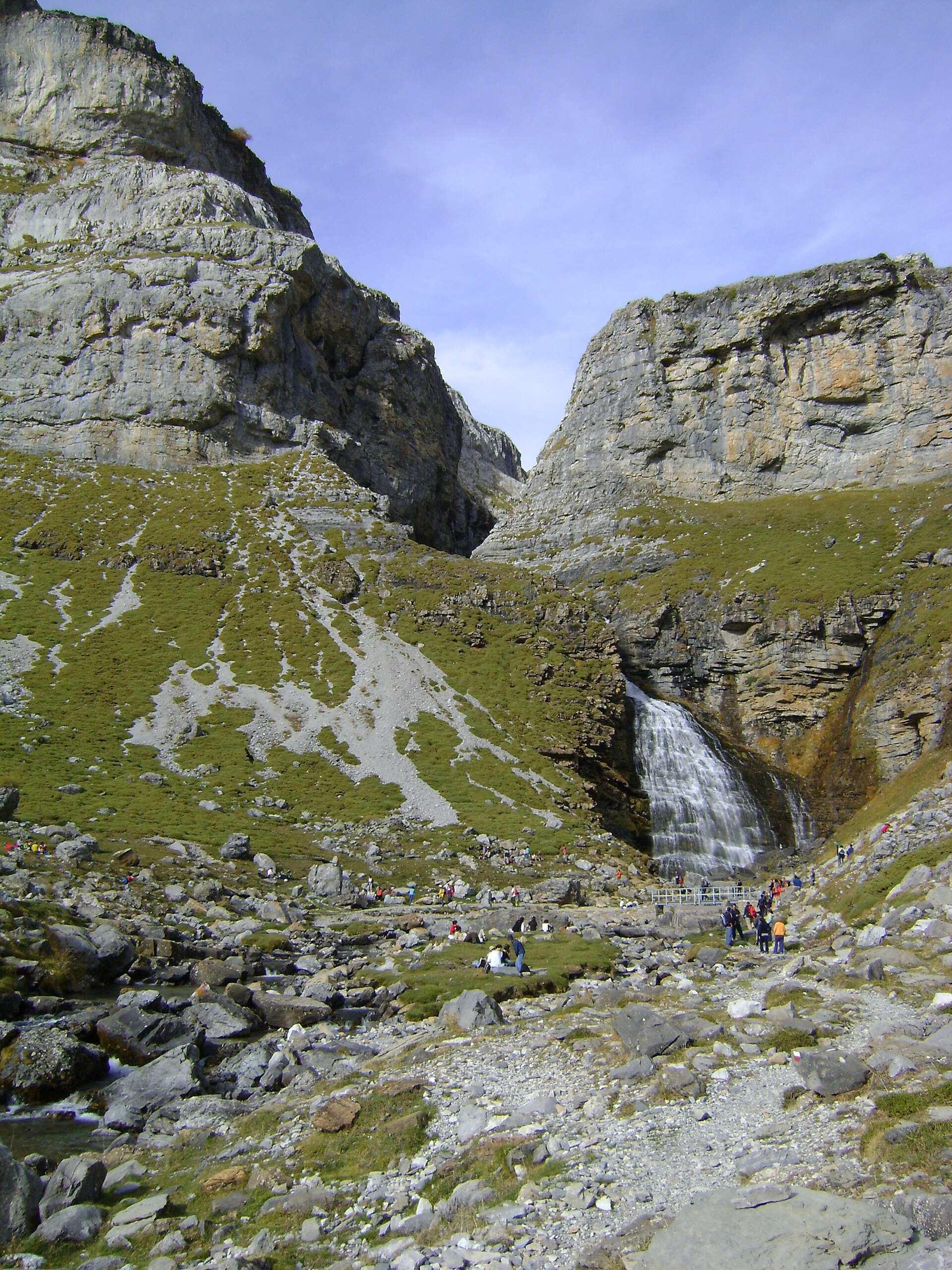
3. Olhadübi and Passerelle d’Holzarte loop
Snapshot
Itinerary
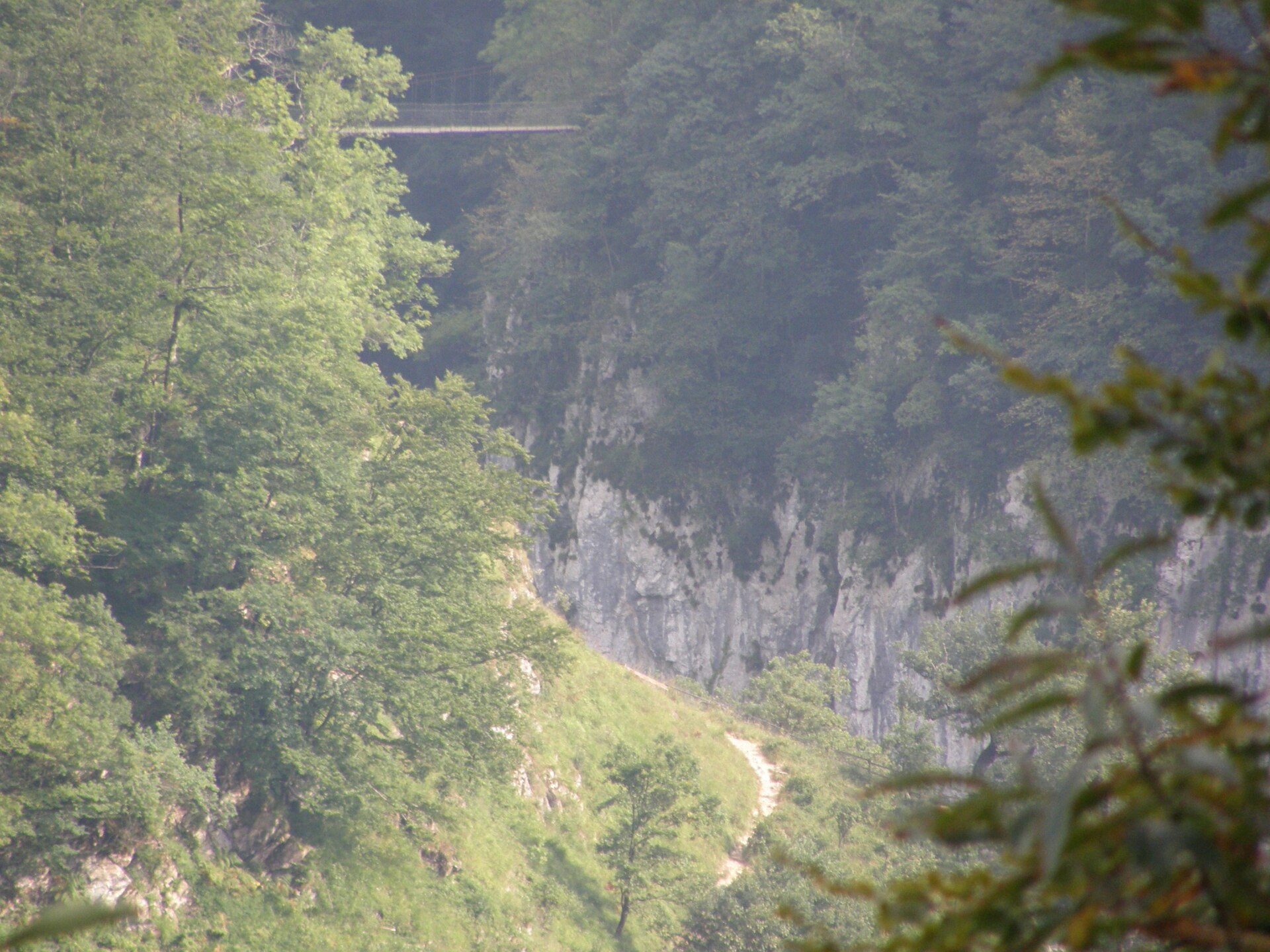
From Logibar, the route follows the gorge approach towards the Passerelle d’Holzarte. The path climbs steeply through wooded and rocky ground, with a small cable-protected passage noted by the official itinerary in wet terrain. The suspension bridge crosses high above the Olhadübi gorge. The full loop then continues towards the upper Olhadübi valley and returns by a longer circuit rather than simply reversing to Logibar.
Why it is essential
The Passerelle d’Holzarte is one of the classic landmarks of the Basque Pyrenees. The official tourism description places the bridge more than 180 m above the gorge and describes the site as one of the most spectacular and frequented in the western Pyrenees.
Equipment
- Sturdy boots
- Weatherproof layer
- Warm layer
- Water and food
- Map or GPS
- Sun protection
- Trekking poles recommended
- Extra care needed in wet conditions
Hazards and notes
- The gorge approach is steep and can be muddy or slippery.
- The suspension bridge is unsuitable for walkers with severe vertigo.
- The official source advises checking weather, wearing good shoes, carrying enough water, staying on marked paths, and keeping dogs on a lead.
- The area is pastoral ground; gates should be closed after passage.
GPX / KML links
| Source | URL | Format | Notes |
|---|---|---|---|
| En Pays Basque official route page | en-pays-basque.fr | GPX + KML + PDF | Official page provides downloadable GPX/KML/PDF; explicit reuse terms not found |
| Randozone | randozone.com | GPX | Third-party route database; terms not checked |
Sources
- En Pays Basque official hiking page
- En Pays Basque route source page
- Tourisme64 Passerelle d’Holzarte
- Randozone
- Wikimedia Commons image page
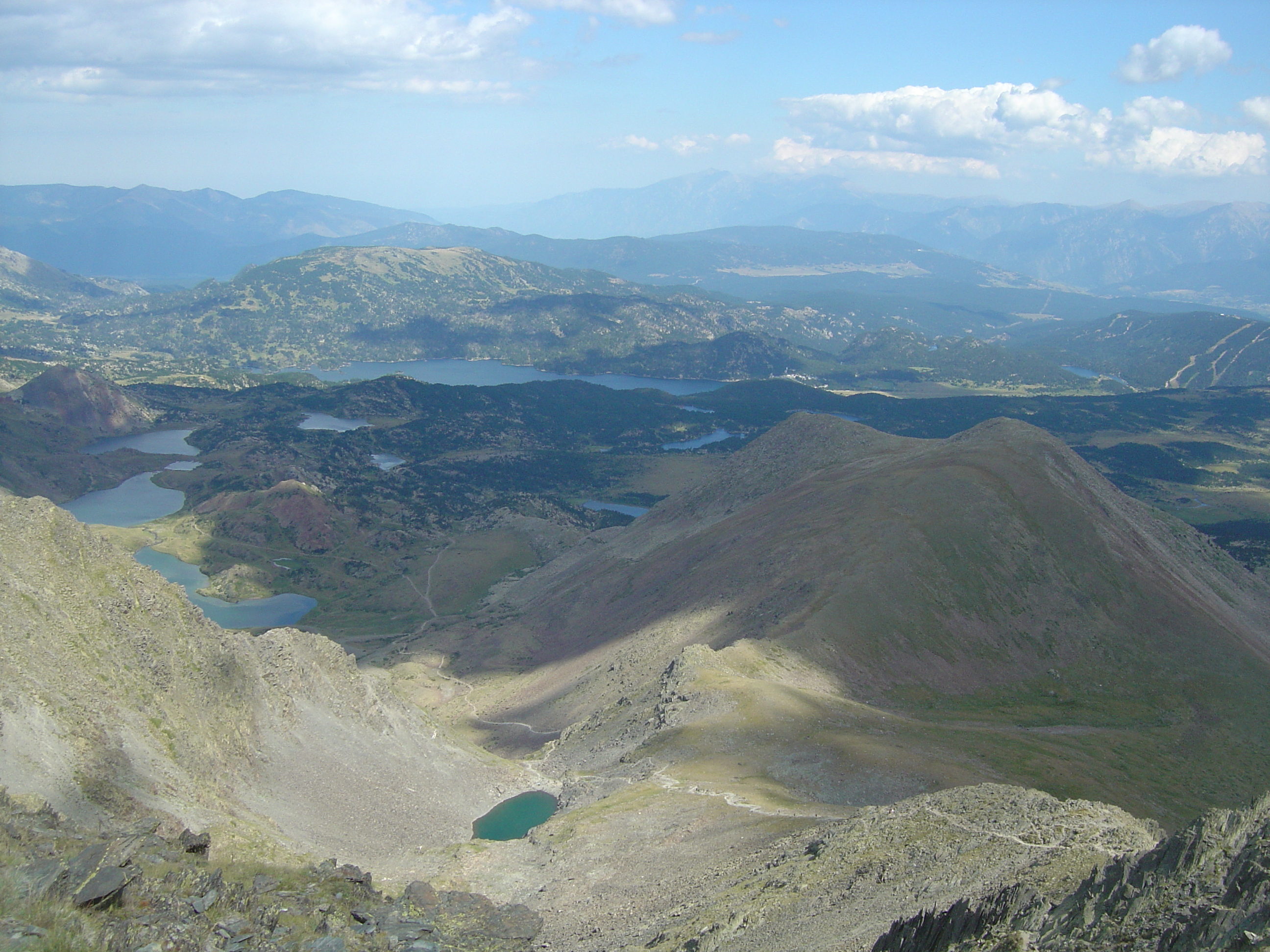
4. Tour des Lacs d’Ayous
Snapshot
Itinerary
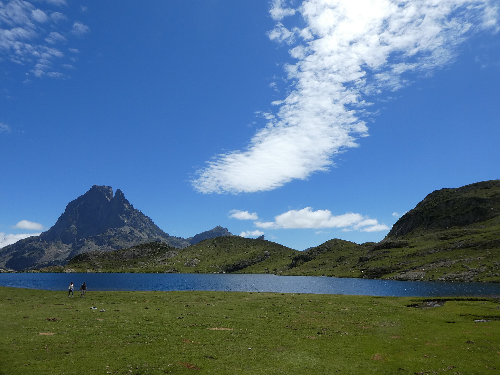
From Bious-Artigues, the route follows the lakeside and climbs through forest on the GR10 towards Lac Roumassot. It then continues past the Ayous lakes, including Lac du Miey and Lac Gentau, with repeated views of Pic du Midi d’Ossau. The circuit returns to Bious-Artigues by a descending loop rather than a simple out-and-back.
Why it is essential
This is the classic lake circuit of the Ossau valley: a compact sequence of high lakes beneath the distinctive silhouette of Pic du Midi d’Ossau. The official tourism page describes the route as a postcard landscape with four lakes below the Pic du Midi d’Ossau.
Equipment
- Sturdy boots
- Weatherproof layer
- Warm layer
- Water and food
- Map or GPS
- Sun protection
- Trekking poles recommended
- Microspikes may be needed if snow remains early in the season
Hazards and notes
- Snow can remain early in the season.
- Storms can develop quickly around the Ossau massif.
- The route enters the Parc national des Pyrénées core area.
- Dogs are prohibited on part of the route.
- National-park restrictions include no dogs even on a lead in the core area, no fires, no drones, and restricted bivouac hours.
GPX / KML links
| Source | URL | Format | Notes |
|---|---|---|---|
| Office de Tourisme de la Vallée d’Ossau | valleedossau.com | GPX + PDF | Official GPX and PDF downloads; reuse terms not explicit |
| Official GPX download | valleedossau.com | GPX | Official download link from Vallée d’Ossau page |
| Official PDF route sheet | valleedossau.com | Official route sheet; reuse terms not explicit |
Sources
- Office de Tourisme de la Vallée d’Ossau
- Official PDF route sheet
- Official GPX download
- Wikimedia Commons image page
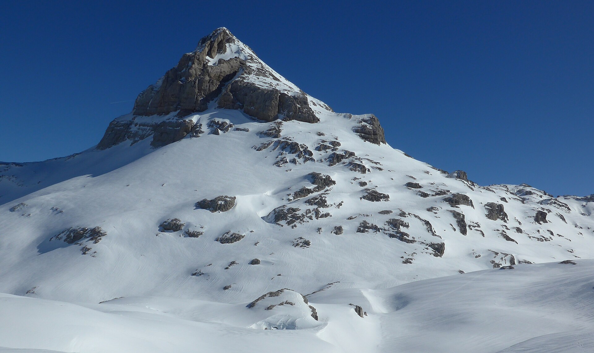
5. Pic d’Anie / Auñamendi from La Pierre Saint-Martin
Snapshot
Itinerary
From the parking area below Refuge Jeandel at La Pierre Saint-Martin, the route initially follows tracks and paths southwards towards the border area and Col de Pescamou. It then crosses complex limestone terrain below Arlas and Soum Couy before turning towards Col des Anies and the final ascent of Pic d’Anie. Return is usually by the same general line, although variants exist.
Why it is essential
Pic d’Anie is the landmark high summit of the western limestone Pyrenees. It gives the region’s strongest high-mountain contrast: karst, lapiaz, border terrain, and wide views over Lescun, Barétous and Navarra. The official tourism page highlights the summit’s position above one of Europe’s largest limestone massifs.
Equipment
- Sturdy boots
- Weatherproof layer
- Warm layer
- Water and food
- Map or GPS plus backup navigation
- Sun protection
- Trekking poles recommended
- Microspikes or crampons may be required if snow remains
- Carry enough water; the karst terrain can be dry
Hazards and notes
- This is the most serious hike in the selection.
- Lapiaz and karst terrain make navigation slow and difficult, especially in fog.
- The route crosses awkward terrain and scree.
- A small rock step may be encountered depending on the line taken.
- Snowfields may remain into the season.
- Early-season snow, poor visibility, storms, or wet limestone can make the route significantly more hazardous.
GPX / KML links
| Source | URL | Format | Notes |
|---|---|---|---|
| Visorando | visorando.com | GPX available from platform | Third-party platform; route-file reuse terms not confirmed |
| VisuGPX route source | visugpx.com | GPX / KML | Third-party platform; terms not checked |
Sources
Region-level sources
| Source | Use |
|---|---|
| Tourisme64 / Nature64 | Official route statistics, route descriptions, GPX/KML availability for La Rhune and Pic d’Orhy |
| En Pays Basque tourism | Official Holzarte route, safety notes, downloadable GPX/KML/PDF |
| Office de Tourisme de la Vallée d’Ossau | Official Lacs d’Ayous route, PDF, GPX, park notes |
| La Pierre Saint-Martin tourism | Pic d’Anie regional and summit context |
| Topopyrénées | Pic d’Anie and Pic d’Orhy mountain-route cross-checking |
| Visorando / Randozone / VisuGPX | Secondary route statistics and GPX/KML/source-route availability |
| Wikimedia Commons | Licence-compatible image candidates |