Regional overview
Junín / Huaytapallana covers the central Peruvian Andes around Huancayo, the Mantaro Valley, the Huaytapallana Regional Conservation Area, and the high Marcapomacocha / Rajuntay sector near the Carretera Central. The walking character is high-altitude puna, glacier-fed lakes, bofedales, rocky moraine, open ridges, and cultural viewpoints above Andean towns.
The main hiking bases are Huancayo, Santa Rosa de Ocopa, Marcapomacocha, and roadheads on the approaches to Huaytapallana and Rajuntay. Huaytapallana itself is an ACR managed by the regional government of Junín with SERNANP support; route access, registration, ritual-use restrictions, and conservation rules should be checked locally before departure.
The best season is generally the drier Andean season from May to October, with cold nights and strong sun. Wet-season mist, hail, snow showers, and poor visibility can make the high routes much more serious. Most trailheads are above 3,300 m and several routes approach or exceed 4,500 m, so acclimatisation is a real safety factor.
Selection rationale
The selection balances the iconic Huaytapallana glacier-lagoon corridor with the adjacent Junín highland lake country and one cultural valley viewpoint. Five near-identical variants from Virgen de las Nieves were avoided; instead, the list includes a Huaytapallana viewpoint loop, a longer ACR lagoons circuit, Laguna Pucacocha, Nevado Rajuntay, and Cerro Jerusalén above Santa Rosa de Ocopa.
Summary table
| # | Hike | Country | Route type | Distance | Gain | Max elevation | Difficulty |
|---|---|---|---|---|---|---|---|
| 1 | Huaytapallana Viewpoint / Ruta de las Lagunas | Peru | Loop | 9.7 km | 553 m | high point approx. 4,700-4,900 m | Hard |
| 2 | ACR Huaytapallana Lagoons Circuit | Peru | Loop | 8.5-10.6 km depending on Wikiloc variant | 619-691 m | Approx. 4,775 m from source waypoints | Hard |
| 3 | Laguna Pucacocha | Peru | Loop | 6.8 km | 314 m | lake country near 4,600-4,800 m | Moderate |
| 4 | Nevado Rajuntay Loop | Peru | Loop | 16.1 km | 709 m | route circles terrain below 5,000 m | Hard |
| 5 | Mirador Cerro Jerusalén | Peru | Out-and-back | 8.9 km | 385 m | Hard |
1. Huaytapallana Viewpoint / Ruta de las Lagunas
Snapshot
Itinerary
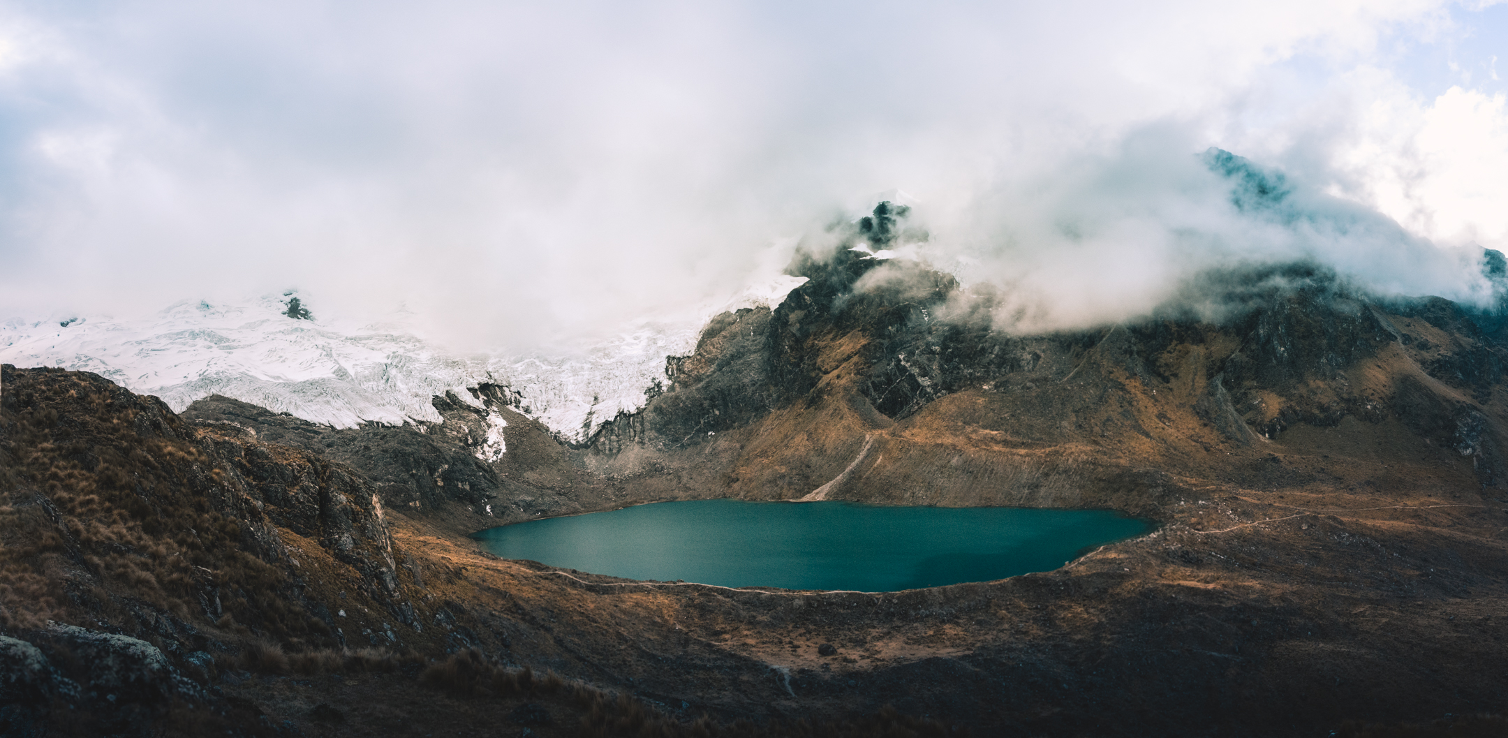
The route starts at the signed ACR checkpoint, where visitors register and receive conservation instructions. It follows the marked loop through the glacier-lagoon sector of Huaytapallana, visiting lakes and viewpoints with views toward Nevado Huaytapallana / Lasuntay, Yana Uqsha, and the Lasuntay glacier area. The terrain is open puna and moraine with little shelter.
AllTrails identifies the route as the Huaytapallana Viewpoint, also known as Ruta de las Lagunas or Huaytapallana Trek. The ACR is managed for water, biodiversity, landscape conservation, sustainable tourism, and environmental education.
Why it is essential
This is the signature day-hike of the Huancayo high Andes: a compact glacier-lake route inside the protected Huaytapallana landscape and the most widely listed walking objective in Junín.
Equipment
- Sturdy boots
- Warm layer
- Waterproof/windproof shell
- Hat and gloves
- Sun hat, sunglasses, sunscreen
- Food and water
- Map/GPS
- Headtorch for delays
- Trekking poles for moraine and wet ground
Hazards and notes
- High, exposed and almost shade-free terrain.
- Weather can change rapidly; wet-season mist can reduce visibility to near zero.
- Do not approach glacier ice without local authorisation and suitable equipment.
- Check current ACR rules, registration requirements, and any temporary restrictions before travel.
GPX / KML links
| Source | URL | Format / access | Reuse status |
|---|---|---|---|
| AllTrails: Huaytapallana viewpoint | alltrails.com | Source map; AllTrails terms apply | No direct GPX retrieved; source-map reference only |
| OpenStreetMap ACR relation reference | openstreetmap.org | OSM relation / protected-area context; ODbL | Context and boundary cross-check |
External links
- AllTrails — Huaytapallana viewpoint
- MINCETUR inventory — ACR Huaytapallana
- Key Biodiversity Areas — Área de Conservación Regional Huaytapallana
2. ACR Huaytapallana Lagoons Circuit
Snapshot
Itinerary
This longer ACR loop uses the established lagoon circuit rather than only the shortest viewpoint line. Wikiloc route descriptions identify Laguna Carhuacocha, Matacocha, Cocha Grande / Hatunqucha, streams, trail markers, and safety gates along the route. The circuit is commonly walked in either direction from the ACR parking and entrance area.
The route stays within the enabled tourist circuit of the ACR. Current local rules matter because parts of the glacier base and ritual zones have been subject to stricter controls related to glacier retreat, water scarcity, and protected-area management.
Why it is essential
The longer lagoon circuit gives the fullest day-walk experience of Huaytapallana without treating the snow summit as a hiking objective. It connects the main glacier-fed lakes and viewpoints that define the ACR landscape.
Equipment
- Sturdy boots
- Warm and waterproof layers
- Gloves
- Sun protection
- Food and water
- Navigation backup
- Trekking poles
- Microspikes only if local conditions report snow or ice on the path
Hazards and notes
- Altitude, cold wind, wet ground, hail, snow showers and poor visibility are the principal hazards.
- Stay on authorised trails to protect bofedales and lake margins.
- Confirm current ACR access, registration, ritual-use restrictions, and whether any route sections are closed.
GPX / KML links
| Source | URL | Format / access | Reuse status |
|---|---|---|---|
| Wikiloc: Huancayo — Circuito Lagunas ACR Huaytapallana Trek 1D | wikiloc.com | Source map / GPX availability via Wikiloc | Wikiloc terms apply; GPX download not retrieved |
| Wikiloc: Huancayo — Huaytapallana ACR Lagoons Trek 1D | wikiloc.com | Source map / route collection | Wikiloc terms apply; stats cross-check |
External links
- Wikiloc — ACR Huaytapallana lagoons circuit
- MINCETUR inventory — ACR Huaytapallana
- Regional Government Junín — Huaytapallana access/control news
3. Laguna Pucacocha
Snapshot
Itinerary
The walk begins near a bend in the high road where Rajuntay is visible, crosses the open valley, and climbs to the green Laguna Pucacocha. AllTrails records the return as a loop rather than a strict out-and-back. The landscape is open, high, and sparsely visited, with lake, river, wildflower, and wildlife features reported.
Why it is essential
Laguna Pucacocha represents Junín’s high lake country outside the Huaytapallana ACR. It is shorter than the Rajuntay loop but still gives a direct glacier-and-lake experience in the Marcapomacocha sector.
Equipment
- Sturdy boots
- Warm layer
- Waterproof/windproof shell
- Sun protection
- Water and food
- Map/GPS and navigation backup
- Trekking poles for wet or tussocky ground
Hazards and notes
- Remote, high terrain.
- Snow, sleet, and storms can occur even when Lima or the Mantaro Valley are warm.
- Little shelter and no confirmed water treatment or rescue infrastructure at the route.
GPX / KML links
| Source | URL | Format / access | Reuse status |
|---|---|---|---|
| AllTrails: Laguna Pucacocha | alltrails.com | Source map; AllTrails terms apply | No direct GPX retrieved; source-map reference only |
External links
4. Nevado Rajuntay Loop
Snapshot
Itinerary
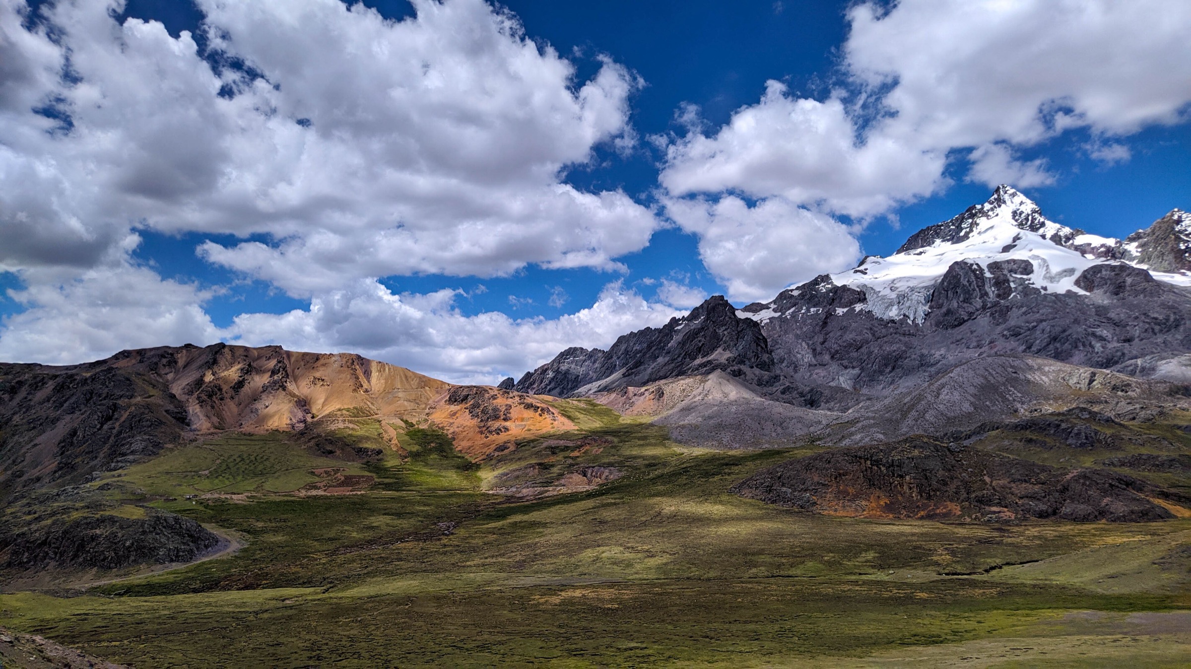
The loop circles high terrain around Nevado Rajuntay north of the Carretera Central / La Oroya corridor. AllTrails describes a demanding route at very high altitude, passing close to Rajuntay glacier viewpoints and Laguna Pucarcocha / Pucacocha features.
The selected hike is the non-technical loop route, not a glacier climb or snow summit ascent. If snow or ice covers the route, the outing becomes more serious and should be reassessed locally.
Why it is essential
Rajuntay is one of the most striking high-mountain day objectives in the central Andes near Lima and Junín. It broadens the Junín selection beyond Huaytapallana while staying within glacier-lake puna terrain.
Equipment
- Mountain hiking equipment with extra warm layers
- Gloves
- Headtorch
- Navigation backup
- Food and water for a long high-altitude day
- Microspikes or ice axe only if current local conditions require snow travel
Hazards and notes
- Very high altitude, rocky ground, no shade, cold wind, snow showers and route-finding in poor visibility are the main concerns.
- Do not continue onto glacier ice without proper equipment, experience, and local guidance.
GPX / KML links
| Source | URL | Format / access | Reuse status |
|---|---|---|---|
| AllTrails: Nevado Rajuntay Loop | alltrails.com | Source map; AllTrails terms apply | No direct GPX retrieved; source-map reference only |
External links
5. Mirador Cerro Jerusalén
Snapshot
Itinerary
From the Plaza de Armas of Santa Rosa de Ocopa, the route climbs toward the Cerro Jerusalén viewpoint above the village. It is a cultural-valley hike rather than a glacier route, with views over Santa Rosa de Ocopa and the surrounding Mantaro highlands.
Why it is essential
This route adds a lower, culturally anchored Mantaro Valley viewpoint to a region otherwise dominated by very high glacier and lake routes. Santa Rosa de Ocopa is one of the best-known cultural stops near Huancayo, and the climb gives a useful acclimatisation-scale day walk.
Equipment
- Hiking shoes or boots
- Weatherproof layer
- Warm layer
- Water and food
- Map/GPS
- Sun protection
Hazards and notes
- Sun exposure, altitude, steep sections and route-finding at local tracks or junctions are the main risks.
- Confirm local access and whether any community restrictions apply.
GPX / KML links
| Source | URL | Format / access | Reuse status |
|---|---|---|---|
| AllTrails: Mirador Cerro Jerusalén | alltrails.com | Source map; AllTrails terms apply | No direct GPX retrieved; source-map reference only |
External links
External links
| Source | URL |
|---|---|
| MINCETUR inventory — ACR Huaytapallana | consultasenlinea.mincetur.gob.pe |
| Key Biodiversity Areas — Huaytapallana | keybiodiversityareas.org |
| Regional Government Junín — Huaytapallana access/control news | regionjunin.gob.pe |
| AllTrails — Junín trail index | alltrails.com |
| AllTrails — Huaytapallana viewpoint | alltrails.com |
| AllTrails — Laguna Pucacocha | alltrails.com |
| AllTrails — Nevado Rajuntay Loop | alltrails.com |
| AllTrails — Mirador Cerro Jerusalén | alltrails.com |
| Wikiloc — ACR Huaytapallana lagoons circuit | wikiloc.com |