Regional overview
The Cusco and Sacred Valley walking area combines high Andean plateau, the Urubamba/Vilcanota river corridor, Inca roads, agricultural terraces, living Quechua towns and major archaeological parks. The hiking character is cultural as much as scenic: several of the strongest day walks use old paths between settlements, climb to terrace systems above the valley, or link sites that are normally visited by road.
The main walking bases are Cusco, Pisac, Chinchero, Urubamba, Ollantaytambo, Maras and Machu Picchu Pueblo. Trail elevations commonly range from about 2,400 m at Machu Picchu to more than 4,300 m on high approaches such as Huchuy Qosqo, so acclimatisation is a real planning factor even where distances are moderate.
The practical dry-season hiking window is roughly April to October, with March-November often usable depending on local rain and trail condition. November-March brings wetter paths, slick stone steps, cloud, mud and higher likelihood of transport disruption. Many archaeological sites require current entry tickets; Pisac, Chinchero and Moray are listed by COSITUC under the Cusco Tourist Ticket, while Machu Picchu requires a separate official timed ticket and route/circuit selection.
Selection rationale
The selection balances five essential Sacred Valley/Cusco experiences: the high traverse to Huchuy Qosqo, the classic Pisac archaeological hike, the downhill Inca road from Chinchero to Urquillos, the Moray-to-Maras cultural landscape walk, and the Intipunku/Inca Bridge route inside Machu Picchu Historic Sanctuary. Higher Ausangate/Vinicunca objectives and Urubamba-range valley hikes are reserved for the neighbouring regional entries to avoid duplication.
Summary table
| # | Hike | Country | Route type | Distance | Gain | Max elevation | Difficulty |
|---|---|---|---|---|---|---|---|
| 1 | Huchuy Qosqo from Tauca/Chinchero to Lamay | Peru | Point-to-point | 18.0 km | 725 m | 4,320 m | Hard |
| 2 | Pisac Town - Pisac Ruins loop | Peru | Loop | 10.8 km | 545 m | 3,477 m | Hard |
| 3 | Chinchero - Urquillos Inca Trail | Peru | Point-to-point | 7.6 km | 67 m | 3,727 m | Easy-moderate |
| 4 | Moray - Maras - Salineras de Maras | Peru | Point-to-point | 10.0 km | 134 m | 3,521 m | Moderate |
| 5 | Machu Picchu - Intipunku - Inca Bridge | Peru | Loop / ticketed site route | 6.3 km | 398 m | 2,712 m | Hard |
1. Huchuy Qosqo from Tauca/Chinchero to Lamay
Snapshot
Itinerary
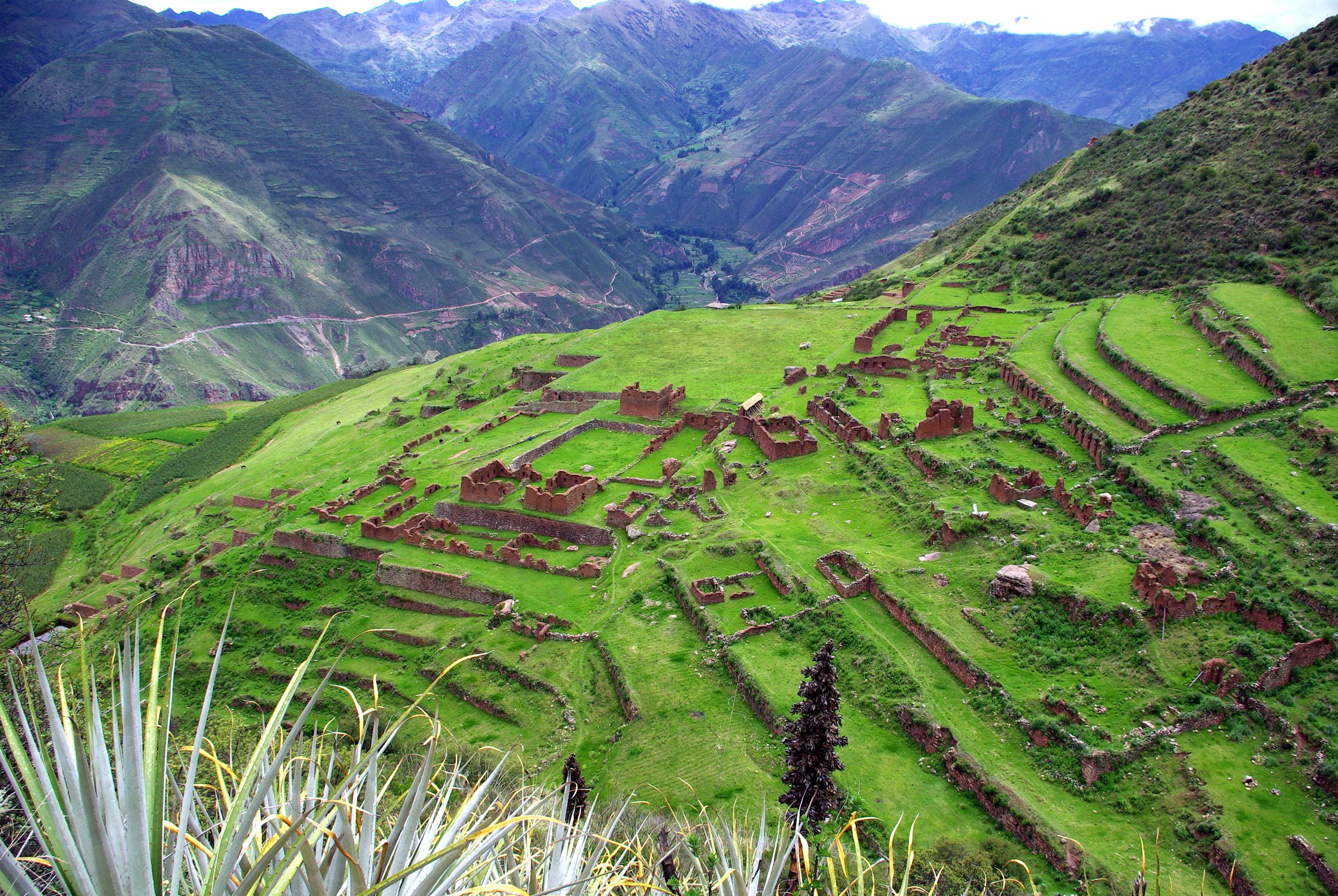
The high-route day traverse starts on the Chinchero/Tauca plateau and climbs toward open puna, small lakes and a pass above 4,000 m before descending toward the Huchuy Qosqo archaeological site. The route then drops steeply by old paths and switchbacks to Lamay in the Sacred Valley. The archaeological site stands on a high bench above the Urubamba/Vilcanota corridor and is reached only on foot by this line or by shorter climbs from Lamay.
AllTrails records the point-to-point route as 18.0 km with 725 m of ascent and a maximum elevation of 4,320 m. Several guide/operator sources publish shorter figures for Tauca-to-Lamay variants, so the catalogue figure should be tied to the AllTrails source-map line rather than treated as universal.
Why it is essential
This is one of the strongest one-day combinations of Sacred Valley landscape and Inca architecture: high puna, an old route across the plateau, a major but less crowded archaeological site, and a dramatic descent to the valley floor.
Equipment
- Sturdy boots
- Waterproof layer
- Warm layer
- Hat and gloves outside stable midsummer weather
- Sun protection
- 2 litres or more of water
- Food
- Map/GPS and navigation backup
- Headtorch
- Trekking poles for the long descent to Lamay
Hazards and notes
- Altitude is the main issue on the high approach.
- The descent to Lamay is steep and can be slippery after rain.
- Wayfinding is more serious than on the main archaeological-park paths, especially in cloud.
- Confirm the legal start point, local entry arrangements and return transport before departure.
GPX / KML links
| Source | URL | Format / access | Reuse status |
|---|---|---|---|
| AllTrails: Huchuy Qosqo | alltrails.com | Source map / downloadable route via AllTrails account; AllTrails terms apply | Source-map reference only; direct GPX not retrieved |
| OpenStreetMap search: Huchuy Qosqo | openstreetmap.org | Map geometry cross-check; OSM data is ODbL | Suitable for geometry cross-check with attribution |
External links
- AllTrails — Huchuy Qosqo
- Huchuy Qosqo site information
- Pacha Expeditions — Huchuy Qosqo hiking guide
- Explorandes — Huchuy Qosqo
2. Pisac Town - Pisac Ruins loop
Snapshot
Itinerary
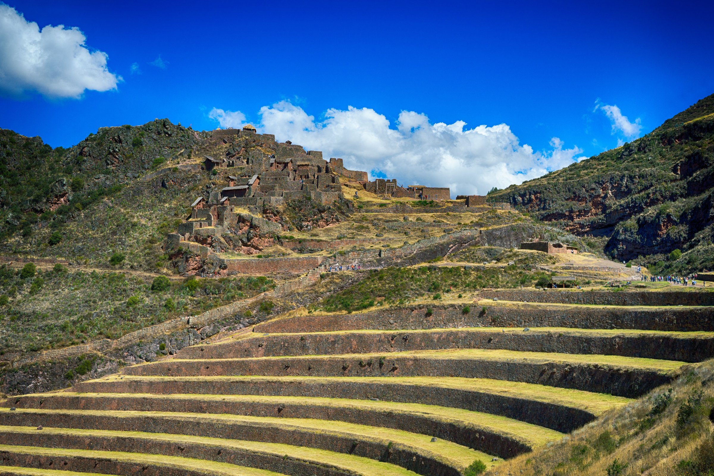
The loop starts in Pisac town and climbs toward the archaeological park, using path and road sections before entering the terrace and ruin complex above the valley. The route crosses the main archaeological sectors, viewpoints and stone stairways, then descends back toward the town. Taxi-to-top and walk-down variants are common, but the loop figure here uses the town-start AllTrails route.
AllTrails records 10.8 km, 545 m of ascent and a maximum elevation of 3,477 m. CuscoPeru notes that the archaeological park lies above the town and that many visitors hike up rather than only using vehicle access.
Why it is essential
Pisac is one of the defining archaeological landscapes of the Sacred Valley, with extensive terraces, ridge-top structures, valley views and a direct pedestrian link between town and site.
Equipment
- Hiking shoes with grip for stone steps
- Water
- Sun protection
- Light rain layer
- Food/snacks
- Map/GPS
- Trekking poles helpful on the descent but awkward on crowded stone steps
Hazards and notes
- The route includes steep stairs, exposed sun, slick stone after rain and archaeological-site controls.
- Dogs are listed as not allowed by AllTrails.
- Current Cusco Tourist Ticket requirements and site opening hours should be checked through COSITUC or local ticket offices before starting.
GPX / KML links
| Source | URL | Format / access | Reuse status |
|---|---|---|---|
| AllTrails: Pisac Town - Pisac Ruin | alltrails.com | Source map / downloadable route via AllTrails account; AllTrails terms apply | Source-map reference only |
| Wikiloc: Pisac/Pisaq ruins loop | wikiloc.com | Source map / GPX through Wikiloc interface; Wikiloc terms apply | Route source identified; reuse terms need review |
| OpenStreetMap search: Pisac ruins | openstreetmap.org | Map geometry cross-check; OSM data is ODbL | Suitable for geometry cross-check with attribution |
External links
- AllTrails — Pisac Town - Pisac Ruin
- CuscoPeru — Pisac Archaeological Park
- COSITUC tariff/ticket source
- Wikiloc — Pisac/Pisaq ruins loop
3. Chinchero - Urquillos Inca Trail
Snapshot
Itinerary
The route leaves Chinchero on an old Inca path and descends from the high plateau toward Urquillos in the Sacred Valley. It passes agricultural land, old stonework, views into the valley, Poq Poq waterfall and minor historic features such as Waka Condorqaqa and Waka Chincana noted by AllTrails. The route is largely downhill, so the modest ascent figure does not reflect the strain of sustained descent.
AllTrails records 7.6 km point-to-point, 67 m of ascent and a maximum elevation of 3,727 m. Other current guide sources describe the same Chinchero-to-Urquillos line as a preserved Inca road connection between the plateau and the valley.
Why it is essential
This is the clearest short day walk in the region for experiencing a functioning old descent route between a major Inca/colonial plateau settlement and the Sacred Valley floor.
Equipment
- Grippy shoes
- Sun protection
- Rain layer
- Water and snacks
- Map/GPS
- Trekking poles to help on the descent
Hazards and notes
- The descent can be slippery after rain.
- Dogs or livestock may be encountered near settlements.
- The Chinchero archaeological zone may require a Cusco Tourist Ticket if visited as part of the day.
- Point-to-point transport should be arranged in advance.
GPX / KML links
| Source | URL | Format / access | Reuse status |
|---|---|---|---|
| AllTrails: Chinchero - Urquillos Inca Trail | alltrails.com | Source map / downloadable route via AllTrails account; AllTrails terms apply | Source-map reference only |
| Wikiloc: Camino inca chinchero urquillos | wikiloc.com | Source map / GPX through Wikiloc interface; Wikiloc terms apply | Route source identified; reuse terms need review |
| OpenStreetMap search: Chinchero Urquillos | openstreetmap.org | Map geometry cross-check; OSM data is ODbL | Suitable for geometry cross-check with attribution |
External links
- AllTrails — Chinchero - Urquillos Inca Trail
- Peru Andean Travel — Chinchero-Urquillos route description
- COSITUC tariff/ticket source
- Wikiloc — Camino inca chinchero urquillos
4. Moray - Maras - Salineras de Maras
Snapshot
Itinerary
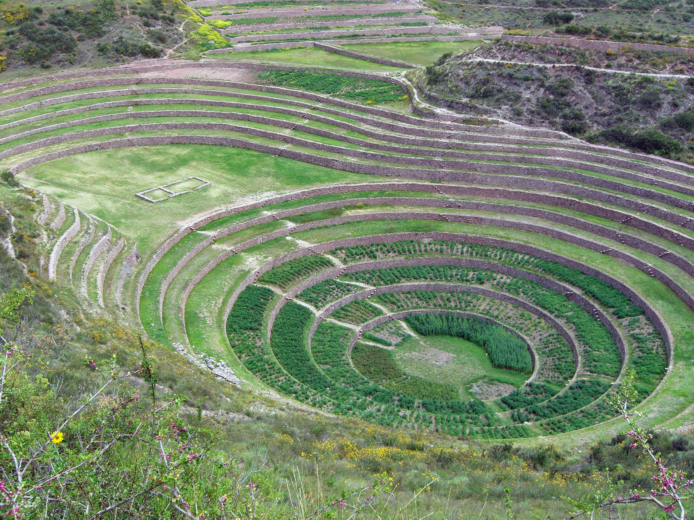
The route begins at Moray, whose circular terrace systems sit on the high plateau west of Maras, then crosses open agricultural country to Maras village and continues toward the salt-pan complex of Salineras de Maras. It links two of the most distinctive cultural landscapes in the Sacred Valley on foot rather than by vehicle.
AllTrails records 10.0 km point-to-point with 134 m of ascent and a maximum elevation of 3,521 m. The route may share sections with mountain bikes, ATVs or local tracks depending on the exact line used.
Why it is essential
Moray and Maras together show the valley’s agricultural and salt-production landscapes in a compact day walk. The hike is less mountainous than Huchuy Qosqo or Pisac, but it is one of the most representative cultural routes in the region.
Equipment
- Hiking shoes
- Sun protection
- Water and snacks
- Light rain layer
- Map/GPS
- Extra water because the plateau is exposed
Hazards and notes
- The main issues are sun exposure, shared tracks with ATVs/bikes, muddy sections in wet months and site-ticket controls.
- Moray is listed by COSITUC under the Cusco Tourist Ticket.
- Salineras de Maras has separate local access management; current visitor rules should be checked locally.
GPX / KML links
| Source | URL | Format / access | Reuse status |
|---|---|---|---|
| AllTrails: Moray - Maras Salt Mines | alltrails.com | Source map / downloadable route via AllTrails account; AllTrails terms apply | Source-map reference only |
| OpenStreetMap search: Moray Maras Salineras | openstreetmap.org | Map geometry cross-check; OSM data is ODbL | Suitable for geometry cross-check with attribution |
External links
- AllTrails — Moray - Maras Salt Mines
- Visit Cusco — Maras-Moray overview
- COSITUC tariff/ticket source
5. Machu Picchu - Intipunku - Inca Bridge
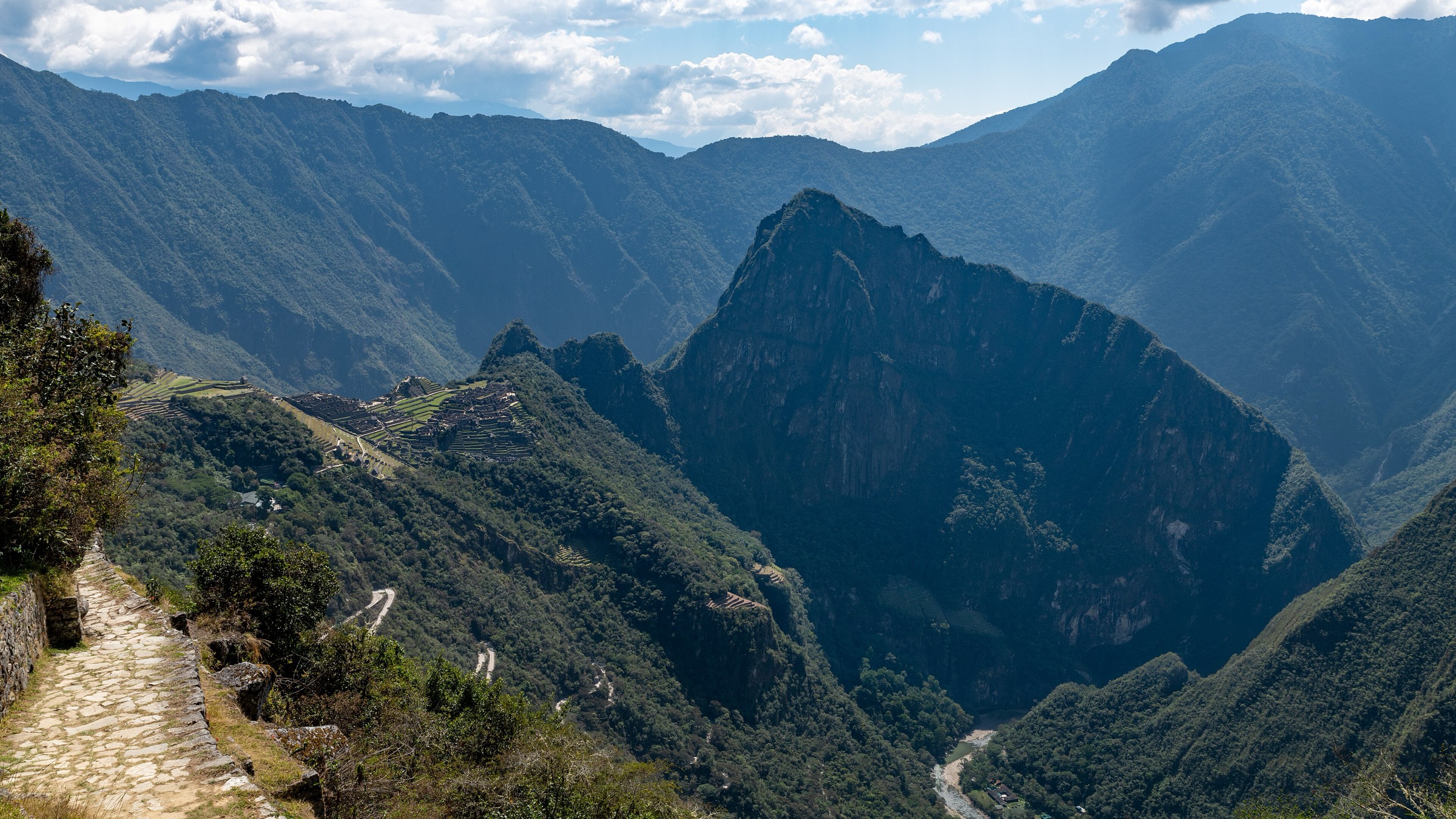
Snapshot
Itinerary
This ticketed site route links the upper panoramic sector of Machu Picchu with the Intipunku/Sun Gate approach and the Inca Bridge side path, depending on the official circuit and route open at the time of visit. The route climbs above the llaqta for the classic high view toward Machu Picchu and the Urubamba valley, then returns through controlled site paths.
AllTrails records 6.3 km as a loop with 398 m of ascent and a maximum elevation of 2,712 m. The official Machu Picchu circuits page lists Intipunku and Inca Bridge as specific routes under the Ministry of Culture route system; availability can be seasonal and ticket-dependent.
Why it is essential
Machu Picchu is the most internationally recognised archaeological landscape in the region. The Intipunku/Inca Bridge route turns the site visit into a real day hike while staying within official controlled paths.
Equipment
- Grippy shoes
- Water
- Sun protection
- Rain layer
- Small daypack compliant with current site rules
- Passport/ID and official ticket details
Hazards and notes
- Timed ticket, route/circuit, seasonal route availability and one-way site controls govern the walk.
- Dogs are not allowed.
- Stone stairs can be slick, and heat, humidity and crowding can be significant.
- Current official Machu Picchu rules should be checked before buying tickets because route names and access windows have changed in recent years.
GPX / KML links
| Source | URL | Format / access | Reuse status |
|---|---|---|---|
| AllTrails: Machu Picchu - Intipunku - Inca Bridge | alltrails.com | Source map / downloadable route via AllTrails account; AllTrails terms apply | Source-map reference only |
| Official Machu Picchu circuits and routes | machupicchu.gob.pe | Official route/circuit information; government site terms not stated for route geometry | Official access reference; no GPX |
| OpenStreetMap search: Machu Picchu Intipunku | openstreetmap.org | Map geometry cross-check; OSM data is ODbL | Suitable for geometry cross-check with attribution |
External links
- AllTrails — Machu Picchu - Intipunku - Inca Bridge
- Official Machu Picchu — circuits and routes
- Machu Picchu official ticket/access site
External links
| Source | URL |
|---|---|
| AllTrails — Huchuy Qosqo | alltrails.com |
| AllTrails — Pisac Town - Pisac Ruin | alltrails.com |
| AllTrails — Chinchero - Urquillos Inca Trail | alltrails.com |
| AllTrails — Moray - Maras Salt Mines | alltrails.com |
| AllTrails — Machu Picchu - Intipunku - Inca Bridge | alltrails.com |
| Wikiloc — Pisac/Pisaq ruins loop | wikiloc.com |
| Wikiloc — Camino inca chinchero urquillos | wikiloc.com |
| COSITUC — Cusco Tourist Ticket tariff | cosituc.gob.pe |
| Official Machu Picchu — circuits and routes | machupicchu.gob.pe |
| Machu Picchu official ticket/access site | machupicchu.gob.pe |
| CuscoPeru — Pisac Archaeological Park | cuscoperu.com |
| Visit Cusco — Maras-Moray overview | visitcusco.org |
| Huchuy Qosqo site information | huchuyqosqo.pe |
| Pacha Expeditions — Huchuy Qosqo hiking guide | pachaexpeditions.com |
| Explorandes — Huchuy Qosqo | explorandes.com |
| Peru Andean Travel — Chinchero-Urquillos | peruandeantravel.com |