Regional overview
The Al Hajar Mountains form the great limestone and ophiolite spine of northern Oman and the eastern United Arab Emirates. Day hiking here ranges from engineered village paths and balcony trails to wadis, abandoned terrace routes, high canyon rims and rough mountain tracks. The normal walking season is the cooler half of the year; heat, flash floods and loose limestone are serious constraints.
This entry balances Oman’s classic canyon and village walks with one UAE route in the northern Hajar. Jabal Shams and Jabal Akhdar supply the high-plateau character, Wakan and Wadi Shab represent village and wadi hiking, and Wadi Shah gives the UAE side of the range a hard day-hike representative.
Selection rationale
The five hikes were selected for recognisability, landscape variety and sourceable route evidence: one canyon-balcony route, one high village/falaj walk, one mountain village stair-and-terrace route, one water canyon and one UAE mountain-wadi loop. Longer traverses and technical canyoning routes were excluded.
Summary table
| # | Hike | Country | Route type | Distance | Gain | Max elevation | Difficulty |
|---|---|---|---|---|---|---|---|
| 1 | W6 Balcony Trail, Jabal Shams | Oman | Out-and-back | 10.0 km | 878 m | 1,886 m | Moderate / exposed |
| 2 | Jebel Akhdar village walk | Oman | Out-and-back | 3.1 km | 191 m | 1,963 m | Moderate |
| 3 | Wakan Village Trail | Oman | Out-and-back | 11.9 km | 707 m | 1,610 m | Moderate |
| 4 | Wadi Shab | Oman | Out-and-back | 5.1 km | 294 m | 117 m | Hard |
| 5 | Wadi Shah loop, Ras al-Khaimah | United Arab Emirates | Loop | 11.9 km | 753 m | 1,086 m | Hard |
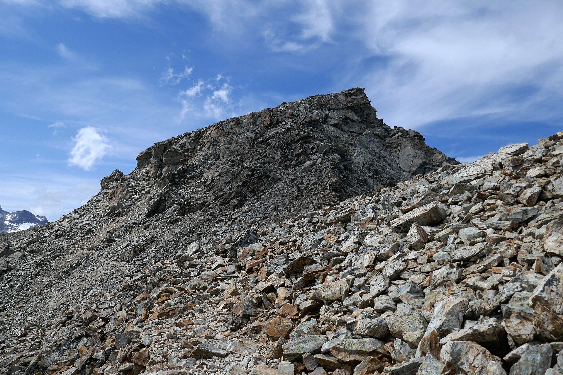
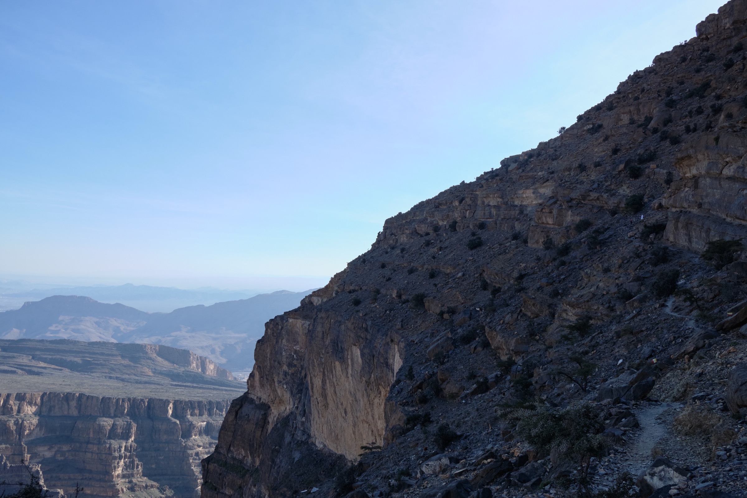
1. W6 Balcony Trail, Jabal Shams

Snapshot
Itinerary
The W6 Balcony Trail traverses the rim wall above Wadi Ghul from the Al Khitaym side, following a ledge-like route to abandoned stone terraces and canyon viewpoints. The walking line is generally clear but exposed in places, with a same-way return.
Why it is essential
This is the signature day hike of Jabal Shams and one of the best-known non-technical mountain walks in Oman, giving big canyon scenery without committing to a rope canyon or a summit route.
Equipment
Hiking shoes, sun hat, sunscreen, 2-3 litres of water, food, wind layer, offline map/GPS and headtorch for margin.
Hazards and notes
Heat, unprotected drops, loose rock and poor visibility near the rim are the main hazards. Do not start during storm or flash-flood risk.
GPX / KML links
| Source | URL | Format / access | Reuse status |
|---|---|---|---|
| AllTrails — W6 Balcony Trail (Jabal Shams) | alltrails.com | Source map / route page | AllTrails terms apply; source-map reference only |
| OpenStreetMap search | openstreetmap.org | Map data / search | OSM data is ODbL; geometry cross-check target |
External links
2. Jebel Akhdar village walk

Snapshot
Itinerary
The village walk links high terraced settlements on the Saiq Plateau, passing old paths, falaj irrigation lines, orchards and viewpoint sections. The AllTrails source route is short, but it can be incorporated into a longer village-and-terrace day if current local paths are confirmed.
Why it is essential
Jebel Akhdar’s high villages and cultivated terraces are one of the Hajar’s defining cultural landscapes, and this is the clearest sourceable short day-walk expression of that terrain.
Equipment
Walking shoes, sun protection, water, modest clothing for villages, rain shell in unsettled weather.
Hazards and notes
Respect private gardens, falaj infrastructure and village etiquette. Route statistics are for the source out-and-back only.
GPX / KML links
| Source | URL | Format / access | Reuse status |
|---|---|---|---|
| AllTrails — Jebel Akhdar | alltrails.com | Source map / route page | AllTrails terms apply; source-map reference only |
| OpenStreetMap search | openstreetmap.org | Map data / search | OSM data is ODbL; geometry cross-check target |
External links
3. Wakan Village Trail

Snapshot
Itinerary
The route climbs from Wakan through village steps, agricultural terraces and mountain slopes, gaining views back across the foothills and into the Hajar. Return is by the same route.
Why it is essential
Wakan is one of the most recognisable Omani mountain-village day hikes, with a direct mix of stairways, orchards, terraces and big dry-mountain views.
Equipment
Hiking shoes, sun protection, water, snacks and wind/rain layer in winter.
Hazards and notes
The climb is exposed to sun and can feel much harder in heat. Respect village privacy and cultivated terraces.
GPX / KML links
| Source | URL | Format / access | Reuse status |
|---|---|---|---|
| AllTrails — Wakan Village Trail | alltrails.com | Source map / route page | AllTrails terms apply; source-map reference only |
| OpenStreetMap search | openstreetmap.org | Map data / search | OSM data is ODbL; geometry cross-check target |
External links
4. Wadi Shab

Snapshot
Itinerary
After the short boat crossing, the walk follows the wadi inward along rock, gravel, ledges and pools. Many parties continue by wading or swimming toward the cave/pool area, then return the same way.
Why it is essential
Wadi Shab is the classic accessible Hajar canyon-water walk: a distinctive contrast to dry high ridges and village terraces.
Equipment
Grippy shoes that can get wet, dry bag, water, sun protection and clothing suitable for wading/swimming. Non-swimmers should not enter deep pools.
Hazards and notes
Flash floods are the critical hazard. Check local weather upstream, avoid storm days and do not enter narrow sections if flooding is possible.
GPX / KML links
| Source | URL | Format / access | Reuse status |
|---|---|---|---|
| AllTrails — Wadi Shab | alltrails.com | Source map / route page | AllTrails terms apply; source-map reference only |
| OpenStreetMap search | openstreetmap.org | Map data / search | OSM data is ODbL; geometry cross-check target |
External links
5. Wadi Shah loop, Ras al-Khaimah

Snapshot
Itinerary
The Wadi Shah loop uses rough old mountain paths and wadi terrain below the Jebel Jais area, passing dry-stone remains, side wadis and steep, loose sections before looping back to the start.
Why it is essential
This gives the UAE Hajar a substantial day-hike representative: rough limestone, Shihuh heritage landscape, wadi navigation and high desert-mountain scenery.
Equipment
Boots or sturdy trail shoes, sun protection, 3 litres of water or more, food, offline GPS/map, first-aid kit and headtorch.
Hazards and notes
Loose rock, heat, route-finding, flash-flood risk and remote terrain are the main hazards. A local guide is recommended if the party lacks UAE wadi experience.
GPX / KML links
| Source | URL | Format / access | Reuse status |
|---|---|---|---|
| AllTrails — Wadi Shah | alltrails.com | Source map / route page | AllTrails terms apply; source-map reference only |
| OpenStreetMap search | openstreetmap.org | Map data / search | OSM data is ODbL; geometry cross-check target |
External links
External links
| Source | URL |
|---|---|
| AllTrails — W6 Balcony Trail (Jabal Shams) | alltrails.com |
| AllTrails — Jebel Akhdar | alltrails.com |
| AllTrails — Wakan Village Trail | alltrails.com |
| AllTrails — Wadi Shab | alltrails.com |
| AllTrails — Wadi Shah | alltrails.com |
| Wikipedia — Jebel Shams | en.wikipedia.org |
| Wikipedia — Jebel Akhdar (Oman) | en.wikipedia.org |
| Wikipedia — Wadi Shab | en.wikipedia.org |
| Wikipedia — Jebel Jais | en.wikipedia.org |
| Wikipedia — Al Hajar Mountains | en.wikipedia.org |