Regional overview
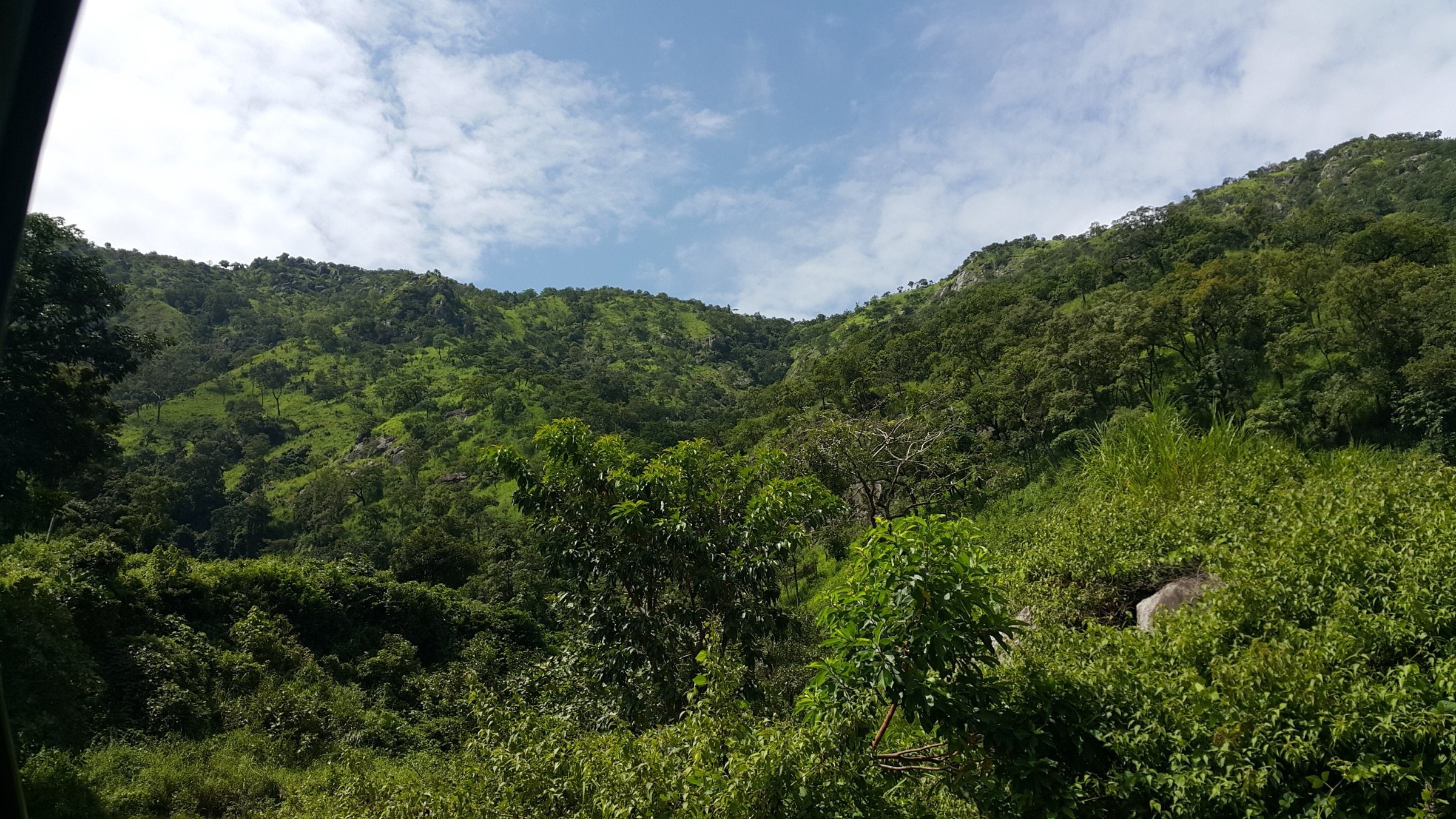
The Jos Plateau is a roughly 8,600 km² granite upland in central Nigeria, lifted to between about 1,200 m and 1,800 m above the surrounding savanna plains of the Middle Belt. Its core sits around Jos and Bukuru in Plateau State, where Precambrian basement rock has been exhumed into a landscape of broad upland grassland, isolated inselbergs, balancing-rock clusters, and short volcanic cones. The plateau is the third-highest landform in Nigeria after the Mambilla Plateau and the Shebshi Mountains, and it gives rise to several of the country’s major rivers, including the Kaduna and tributaries of the Benue.
Walking is concentrated in three main areas. The Shere Hills east of Jos carry the plateau high point at around 1,829 m and the bulk of the long ridge walks. The Riyom and Bokkos belt south-west of Jos is the country’s headline rock-formation district, with the Riyom “Three Rocks” and the Kahwang basalt columns set above wide farmland. The escarpment edge — where the plateau drops to the Kagoro plain on the west — carries waterfall walks at Assop and Kurra. The volcanic cones of the Kerang field near Mangu and the trachyte inselberg of Wase Rock to the south complete the upland’s geomorphic range.
Terrain is open, sun-exposed, and granular underfoot: weathered granite, basalt scree, lateritic earth, and short grass with scattered acacia. There is no high-altitude technical ground and no permanent snow. The dry season from November to February brings the cool Harmattan, firm trail surfaces, and the clearest light; the wet season from April to October is greener but rock surfaces become slippery and afternoon thunderstorms are routine. Mid-day heat at the lower-elevation inselbergs such as Wase Rock is significant year-round.
Security context must inform every visit. Plateau State has experienced periodic intercommunal violence and farmer-herder clashes over the past two decades, and several routes traverse rural areas where conditions can change quickly. The UK Foreign, Commonwealth and Development Office and the US State Department issue regularly updated advice on travel to Plateau State, including restrictions on movement in some local government areas. Visitors should consult current FCDO and US State Department advisories before travel, arrange routes through reputable local operators, hire local guides, and follow Nigerian state-government guidance on permitted movement. The hikes below are described as geographical objects; their walkability on any given day depends on prevailing local conditions.
Selection rationale
The five hikes were chosen to represent the Jos Plateau’s full geomorphic range in a single set: the high open ridge of the Shere Hills, the iconic balancing-stone formation at Riyom Rock, the trachyte volcanic plug of Wase Rock, the columnar basalt outcrops of Kahwang, and the western escarpment waterfall walk at Assop Falls. Together they cover the plateau core near Jos, the Riyom belt south-west, the southern Wase outlier in the Benue lowland, and the western escarpment edge. Each is widely cited in Nigerian tourism sources and identified by Plateau State tourism literature as a representative outing.
Summary table
| # | Hike | Country | Route type | Distance | Gain | Max elevation | Difficulty |
|---|---|---|---|---|---|---|---|
| 1 | Shere Hills ridge to plateau high point | Nigeria | Out-and-back | ~10-12 km | ~400-500 m | ~1,829 m | Moderate |
| 2 | Riyom Rock balancing-stones loop | Nigeria | Short loop / out-and-back | ~3-5 km | ~150-250 m | ~1,250 m | Easy to moderate |
| 3 | Wase Rock circuit | Nigeria | Loop around the plug | ~6-8 km | ~150 m | ~543 m | Moderate (no summit) |
| 4 | Kahwang basalt columns walk | Nigeria | Out-and-back | ~4-6 km | ~150-200 m | ~1,300 m | Easy to moderate |
| 5 | Assop Falls gorge descent | Nigeria | Out-and-back | ~2-4 km | ~80-120 m | ~1,000 m | Easy |
1. Shere Hills ridge to plateau high point
Snapshot
Itinerary
The Shere Hills carry the highest ground on the Jos Plateau and run roughly north-south for several kilometres east of Jos city. Access tracks leave the Jos-Bauchi road and climb through farmland and tin-mining ground to the ridge shoulder. The walking line follows the open grass and granite-boulder crest with views west across Jos and the central plateau, and east into the Bauchi escarpment country. The high point — variously reported at around 1,829 m and 1,759 m by different sources — sits along the main ridge. The Gog and Magog rock pair is a recognisable landmark on the section near Jos. Return is by the same line.
Why it is essential
The Shere Hills are the defining ridge walk of central Nigeria and the only easily accessible route on or near the Jos Plateau high point. Plateau State tourism literature and Nigerian adventure sources consistently rank the Shere Hills among the country’s primary hiking destinations, and the ridge view captures the open-grassland-and-granite character of the plateau.
Equipment
- Sturdy hiking shoes or boots
- Sun hat and high-SPF sun protection
- Minimum 2-3 L water per person
- Wind layer for the ridge
- Light snack and food for a full-day outing
- Local guide strongly recommended; arranged through Jos-based operators
Hazards and notes
- Sun and wind exposure on the open ridge; no shade for long sections.
- Loose granite and quartz scatter underfoot in places.
- Disused tin-mining workings on the lower flanks; avoid edges.
- Phone signal is intermittent.
- Security situation in Plateau State changes; confirm current local advice and consider hiring a local guide.
- The Shere Hills area has hosted military/training installations historically; follow any local instructions.
GPX / KML links
| Source | URL | Format / access | Reuse status |
|---|---|---|---|
| OpenStreetMap — Shere Hills search | openstreetmap.org | Source map / search | OSM data is ODbL; geometry cross-check only |
| PeakVisor — Shere Hills page | peakvisor.com | Reference page | GPX reuse unresolved |
External links
2. Riyom Rock balancing-stones loop
Snapshot
Itinerary
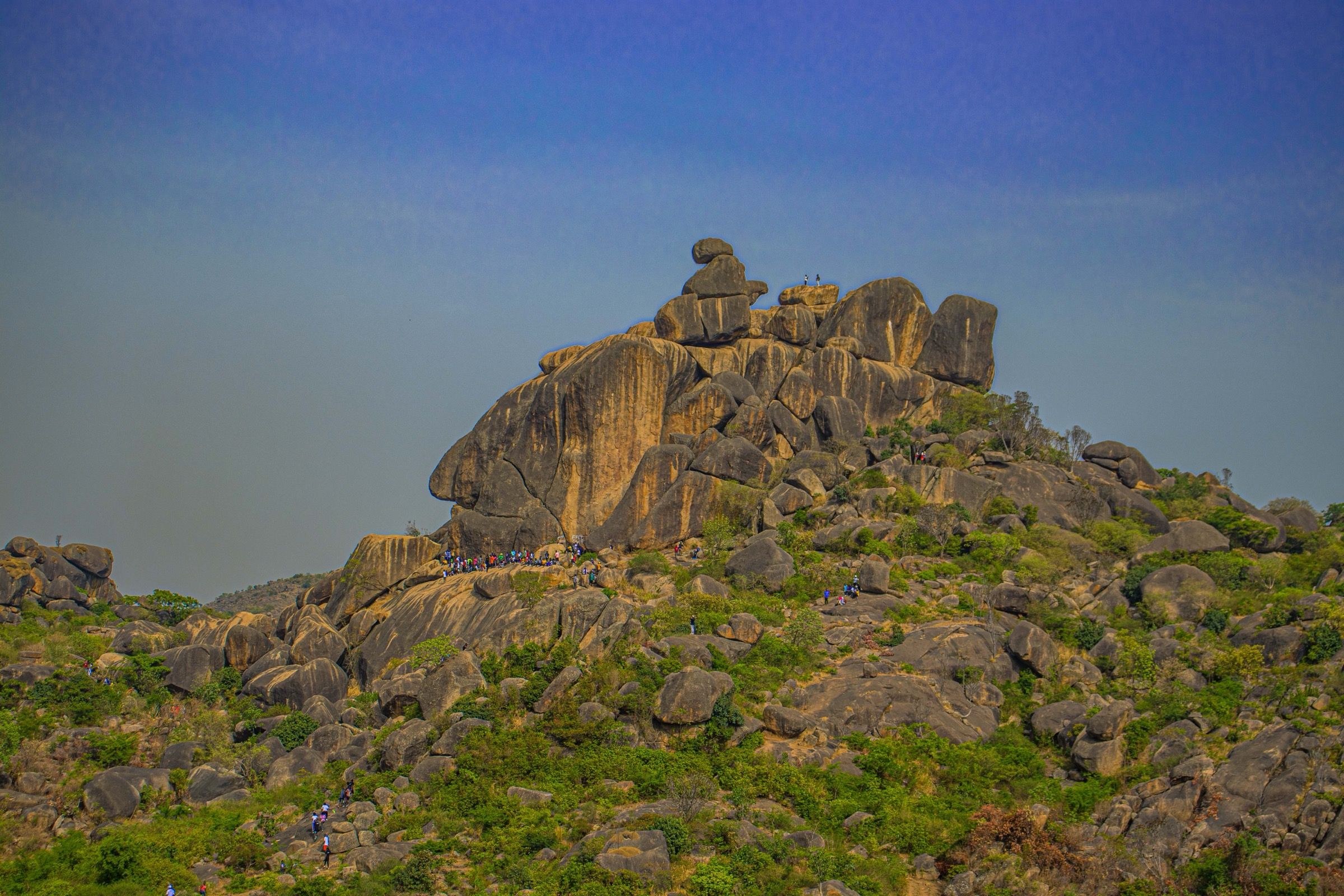
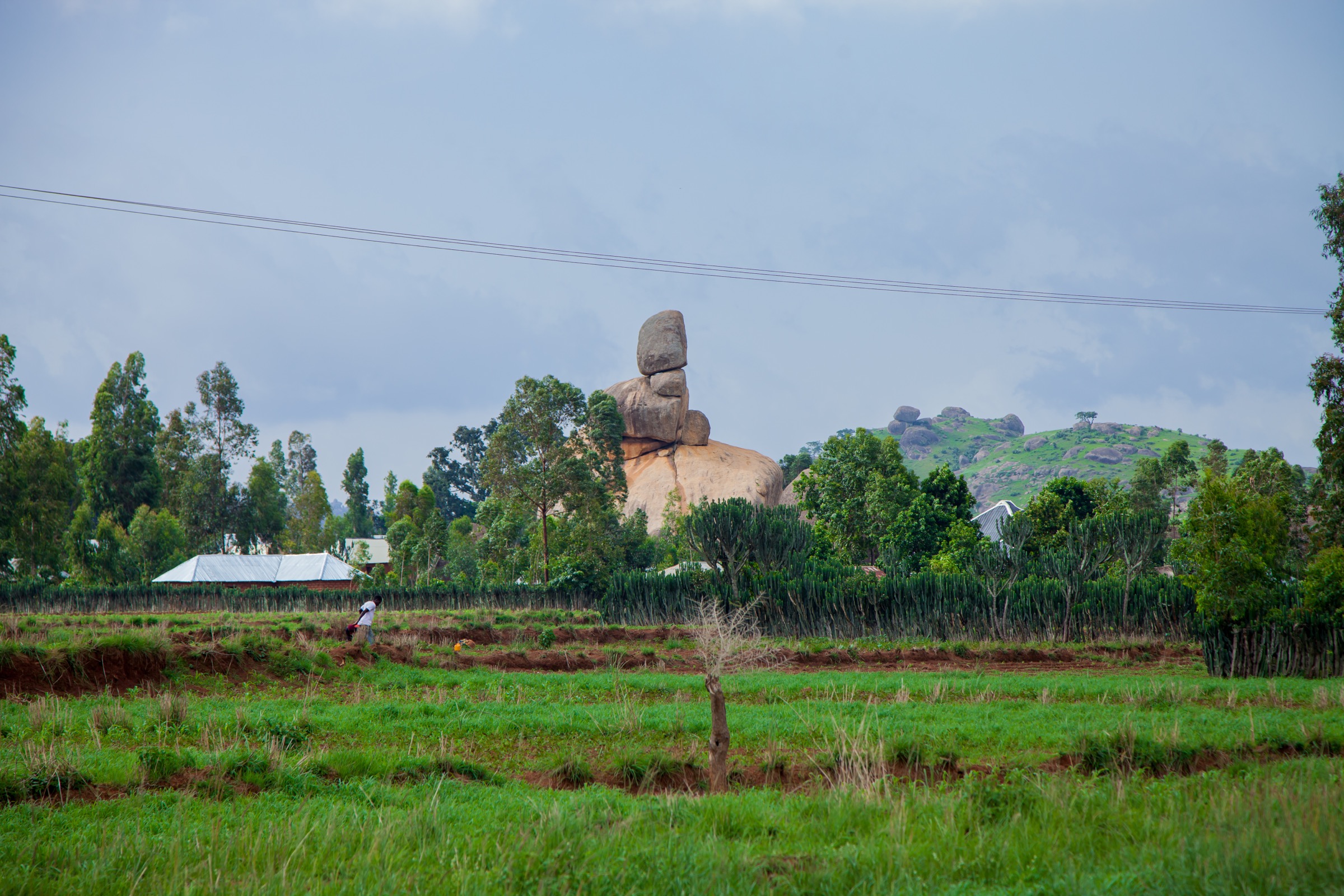
The Riyom Rock formation sits at the village of Riyom on the Jos-Akwanga road, around 35 km south-west of Jos. The classic feature is a stack of three large granite boulders balanced one on top of another, with the uppermost stone tilted toward the sky — the basis for its popular name “Three Rocks”. From the roadside entrance a short path leads through farmland to the base of the formation. A scrambling line gains the lower terraces around the boulders; the upper stack is approached on hand and foot and requires care. A short circuit traces the surrounding farmland with classic angles on the stack and on neighbouring smaller granite domes. Local fees are collected at the entrance and a community guide is normally arranged on site.
Why it is essential
Riyom Rock is the most photographed natural feature on the Jos Plateau and one of the most recognisable rock formations in Nigeria. Local tradition holds that from a particular angle the stack outlines the shape of Plateau State on the national map. Inclusion in the set is non-negotiable for a Jos Plateau day-hike catalogue.
Equipment
- Sturdy hiking shoes
- Sun hat and sun protection
- 1-2 L water per person
- Cash for local entry fee (community-collected)
- Local community guide arranged at the entrance
Hazards and notes
- Scrambling on the upper boulders is exposed; loose rock and gravel underfoot.
- Strong sun and limited shade.
- Snakes occur in the farmland and rock crevices.
- Respect community boundaries and photograph residents only with permission.
- Plateau State security advisories apply; verify current conditions before travel.
GPX / KML links
| Source | URL | Format / access | Reuse status |
|---|---|---|---|
| OpenStreetMap — Riyom Rock search | openstreetmap.org | Source map / search | OSM data is ODbL; geometry cross-check only |
External links
3. Wase Rock circuit
Snapshot
Itinerary
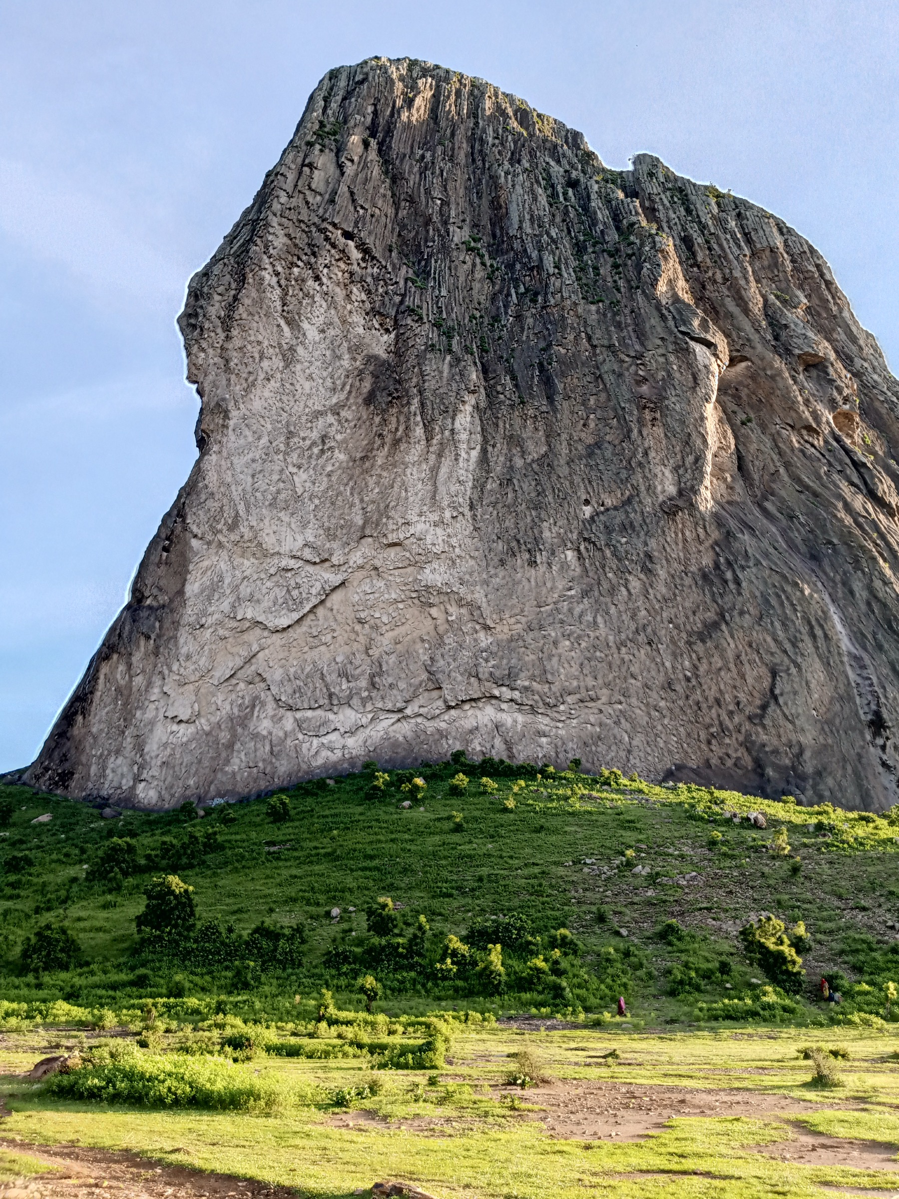
Wase Rock is a trachyte neck — the eroded core of an ancient volcano — rising approximately 295 m above the Wase plain in the south of Plateau State. The published summit elevation is 543 m. The base circuit follows farmland tracks and short bushveld paths around the inselberg from Wase town, giving a continuous panorama of the dome and its near-vertical faces. The circuit is the standard walking option: the summit itself is a technical rock climb on steep slabs and is not a day-hike objective. The Wase Rock vicinity is also a designated bird sanctuary and the only confirmed Nigerian breeding site of the white-backed vulture. Return is to Wase town.
Why it is essential
Wase Rock is geomorphically the most striking single feature in Plateau State — a near-vertical 295 m trachyte plug standing alone above the Benue lowland — and it represents the volcanic component of the plateau’s geology that complements the granite inselbergs farther north. The base circuit is the only feasible day-hike treatment of the formation for general walkers.
Equipment
- Sturdy hiking shoes
- Sun hat and high-SPF sun protection
- Minimum 3 L water per person; lowland heat is significant
- Light long-sleeve layer for sun and bush
- Local guide arranged in Wase town
Hazards and notes
- Severe mid-day heat in the lowland setting; start early.
- Snakes in the dry bushveld near the base.
- The summit is a technical climb, not a hike — do not attempt without rope and experienced leader.
- Wase LGA is in southern Plateau State; confirm current security advisories before travel.
- Photography of the vulture sanctuary should be done without disturbing nests.
GPX / KML links
| Source | URL | Format / access | Reuse status |
|---|---|---|---|
| OpenStreetMap — Wase Rock search | openstreetmap.org | Source map / search | OSM data is ODbL; geometry cross-check only |
| PeakVisor — Wase Rock page | peakvisor.com | Reference page | GPX reuse unresolved |
External links
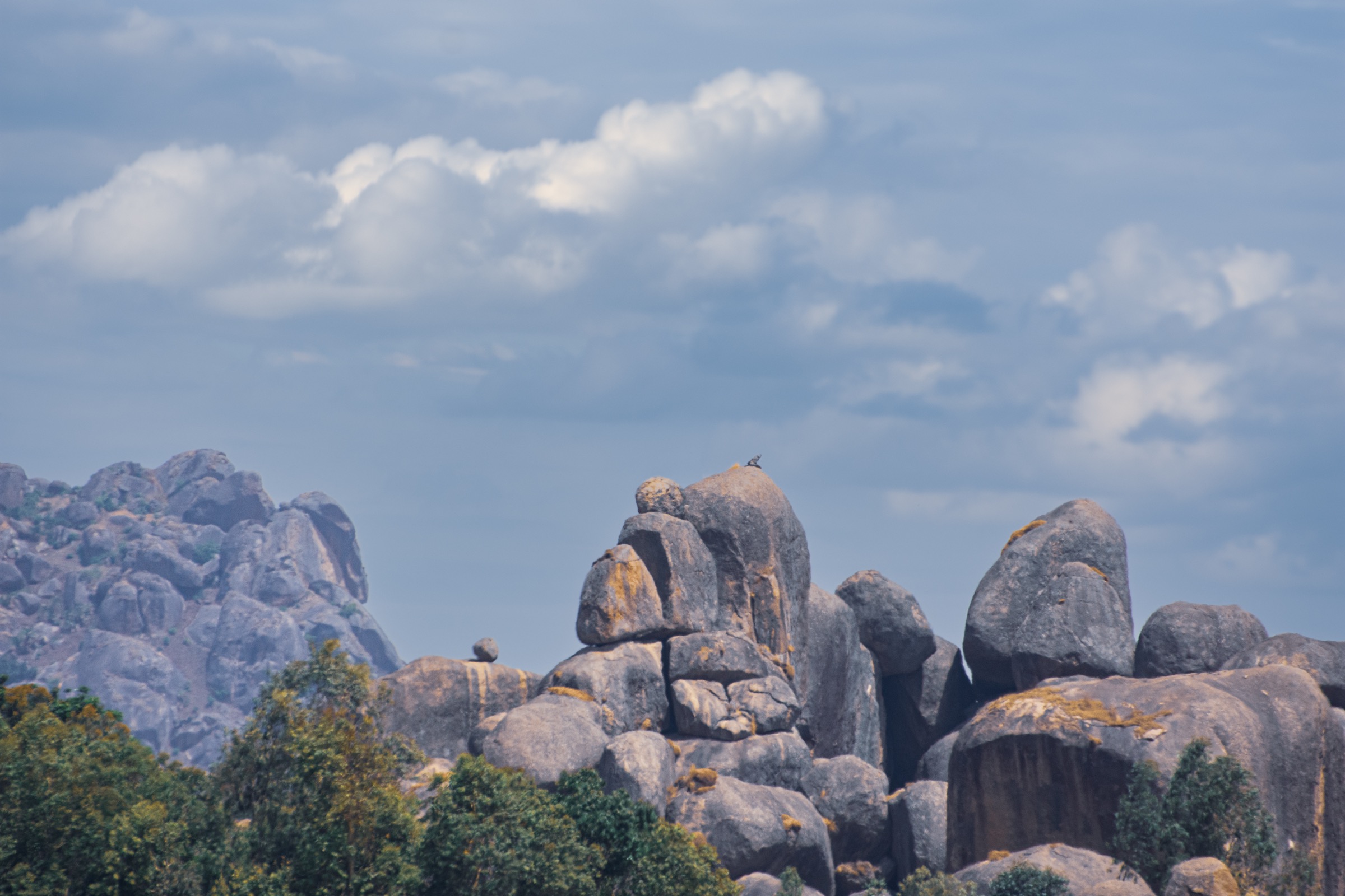
4. Kahwang basalt columns walk
Snapshot
Itinerary
The Kahwang basalt formations stand in the Riyom LGA south-west of Jos, in the same belt as Riyom Rock and reached on the same Jos-Akwanga road corridor. The formation consists of columnar basalt outcrops — vertical hexagonal columns produced by slow cooling of a basaltic flow — rising above farmland. From the village a short approach across cultivated fields leads to the foot of the columns. A walk along the base and up onto adjacent granite shoulders gives close-up views of the columnar structure and across to other inselbergs in the Riyom belt. Return is by the approach line. Community guides are typically arranged in the village.
Why it is essential
The Kahwang columns are one of the few exposures of columnar basalt readily accessible to walkers in Nigeria and the principal geological complement to the granite stacks at Riyom. Combined with Riyom Rock on the same day, they give the most concentrated tour of the Jos Plateau’s classic inselberg-and-column geology.
Equipment
- Sturdy hiking shoes
- Sun hat and sun protection
- 1.5-2 L water per person
- Light snack
- Local community guide arranged at the village
- Cash for any community fees
Hazards and notes
- Loose blocks at the base of the columns; do not climb the columns themselves.
- Strong sun, little shade.
- Respect farmland boundaries and crops.
- Plateau State security advisories apply; route shares the Jos-Akwanga corridor with Riyom Rock.
GPX / KML links
| Source | URL | Format / access | Reuse status |
|---|---|---|---|
| OpenStreetMap — Kahwang search | openstreetmap.org | Source map / search | OSM data is ODbL; geometry cross-check only |
External links
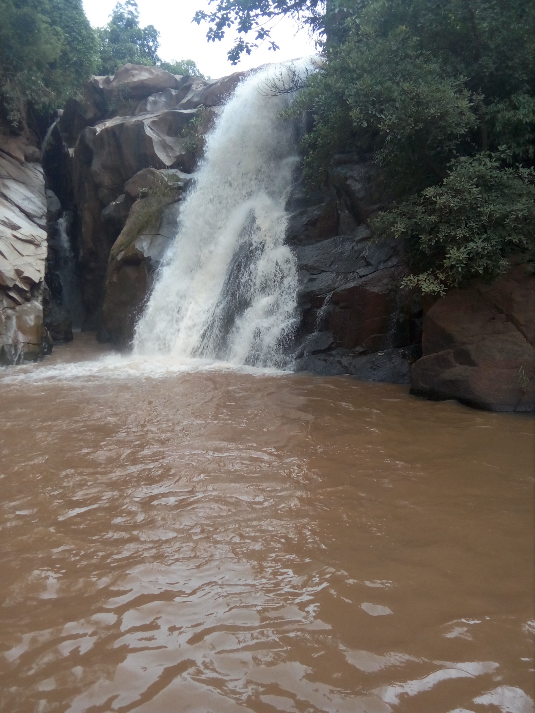
5. Assop Falls gorge descent
Snapshot
Itinerary
Assop Falls sits at the western edge of the Jos Plateau on the Jos-Abuja road, where the plateau drops to the lower Guinea savanna. From the signposted entrance a short path leads to the rim viewpoint and then down a series of steps and a worn track into the small gorge below the falls. The fall itself is a single drop into a forest pool; the surrounding gallery forest contrasts sharply with the open grassland above. The walk is short, but the wet steps and the climb back to the rim give it moderate effort in the descent direction. A small entry fee is collected at the entrance and a guide is normally arranged at the site.
Why it is essential
Assop Falls is the headline waterfall walk on the western escarpment of the Jos Plateau and the standard short stop on overland routes between Jos and Abuja. It is the simplest way to see the plateau-edge transition between the upland grassland and the Guinea savanna gallery forest and is widely cited in Plateau State tourism literature.
Equipment
- Walking shoes with grip; tread is slippery on the descent
- Sun protection
- 1-2 L water per person
- Towel and swim kit if planning to enter the pool
- Cash for entry fee
Hazards and notes
- Slippery wet steps on the descent into the gorge.
- The pool is unsupervised; swim at own risk.
- Snakes occur in the gallery forest.
- The falls sit on the Jos-Abuja highway; check current security advice for the corridor and travel in daylight only.
GPX / KML links
| Source | URL | Format / access | Reuse status |
|---|---|---|---|
| OpenStreetMap — Assop Falls search | openstreetmap.org | Source map / search | OSM data is ODbL; geometry cross-check only |
External links
Missing data / follow-up work
- No officially published GPX/KML downloads were located for any of the five routes; OpenStreetMap, PeakVisor, and Nigerian tourism references are used as geometry pointers only.
- The Shere Hills high point is given variously as 1,829 m and 1,759 m by different sources; a published survey reference would resolve the discrepancy.
- Riyom Rock, Kahwang, and Assop Falls entry and guide fees are community-collected and change frequently; confirm current rates on site.
- Public transport links from Jos to Wase town and to the smaller Riyom and Kahwang villages are limited; private vehicle plus motorcycle-taxi is the practical access mode.
- Plateau State security conditions are subject to change; the route notes above describe geographical features, not a current safety endorsement. Travellers must consult up-to-date FCDO and US State Department advisories and engage reputable local operators before any visit.
- No licence-compatible images of the Kerang volcanoes or of Kurra Falls’ upper trail were used in this pass; both would be candidates for a second selection if access advice improves.