Regional overview
The Adamawa Plateau, also written Adamaoua, is a vast highland that runs roughly 1,000-1,500 m above sea level across northern Cameroon, eastern Nigeria, and the western edge of the Central African Republic. It is the southern dividing watershed for the Lake Chad basin, the source of the Benue and several other major rivers, and the geographical hinge between the Cameroon Volcanic Line and the wider Guinea-Congolian highlands. Vegetation is a mosaic of montane grassland, gallery forest, and small patches of submontane evergreen forest at altitude.
The plateau’s named highpoints sit on its margins. Tchabal Mbabo (2,460 m) and the Hosséré Vokré massif lie in the Cameroonian Adamaoua and North regions; Chappal Waddi (2,419 m), often called Gangirwal in Fulfulde, anchors the Mambilla Plateau on the Nigerian side inside Gashaka-Gumti National Park. Crater lakes and waterfalls fed by the regional water-tower hydrology — Lac Tison, Lac Mbalang, the Chutes de la Vina and the Chutes de Tello — are the most accessible day-hike objectives from Ngaoundéré, the regional capital and the rail-head of the Transcameroonian Railway.
Security conditions on the Cameroonian side of the plateau, particularly in the North and Adamaoua regions, are unsettled at the time of writing, with armed-group activity and kidnapping advisories affecting independent travel; the Nigerian Mambilla / Gashaka-Gumti side requires advance national-park registration and an assigned ranger. Most published routes are partial: distances and ascent figures are scarce, named trailheads are rare, and several candidate objectives are listed only by name in tourism material. Verification labels reflect this; nothing should be read as a confirmed waymarked tourist trail.
Selection rationale
The selection covers the plateau’s three documented walking themes: a marquee summit in Nigeria, a flagship Cameroonian peak, and the accessible crater-lake / waterfall day walks around Ngaoundéré. Chappal Waddi is included because it is the most thoroughly published peak in West Africa with a sourceable climbing protocol. Tchabal Mbabo is retained as the highest point on the plateau proper despite weak hiking-specific data, with security caveats. Lac Tison, the Chutes de la Vina, and the Chutes de Tello provide the realistic short-day objectives that most visitors can attempt from Ngaoundéré without crossing security-sensitive frontiers.
Summary table
| # | Hike | Country | Route type | Distance | Gain | Max elevation | Difficulty |
|---|---|---|---|---|---|---|---|
| 1 | Chappal Waddi (Gangirwal) | Nigeria | Out-and-back summit; ranger-assisted | About 15 km one way per source | Unresolved; significant | 2,419 m | Hard; permits, ranger required |
| 2 | Tchabal Mbabo summit approach | Cameroon | Out-and-back, unverified | Unresolved | Unresolved | 2,460 m | Candidate only |
| 3 | Lac Tison crater-lake loop | Cameroon | Loop / lakeshore walk | Unresolved; about 2-4 km estimated | Minimal | About 1,111 m | Easy |
| 4 | Chutes de la Vina waterfall walk | Cameroon | Out-and-back | Unresolved; short approach | Minimal | Plateau level | Easy |
| 5 | Chutes de Tello waterfall walk | Cameroon | Out-and-back | Unresolved; short approach from Tello | Minimal | About 1,532 m at village | Easy-moderate |
Before you go
Required equipment
- Sturdy hiking boots for Chappal Waddi and Tchabal Mbabo; trail shoes are sufficient for the waterfall and crater-lake walks.
- Sun protection, hat, and 3-5 litres of water carry on the long summit days; the upper grassland zones are very exposed.
- Warm layer and windproof shell for night/early morning at altitude on Chappal Waddi.
- Malaria chemoprophylaxis (year-round risk across all five sites) and a high-DEET repellent.
- Permits and pre-arranged guiding for Chappal Waddi and the Tchabal Mbabo / Faro reserve area.
- Up-to-date security briefing for any movement on the Cameroonian Adamaoua and North regions.
Current access and safety notes
- The U.S. and most European foreign offices advise against non-essential travel to the North and Adamaoua regions of Cameroon at the time of writing; the Tchabal Mbabo entry should be treated as aspirational and not as a confirmed-go trip.
- Chappal Waddi requires registration with Gashaka-Gumti National Park and an assigned armed ranger; independent ascents are not permitted.
- Malaria, typhoid, and yellow fever exposure is present across the plateau; consult current health guidance.
- Water sources at altitude are unreliable; carry capacity sufficient for the planned route plus a margin.
- Mobile coverage outside major towns and at altitude is patchy to absent; expect a remote-rescue context.
1. Chappal Waddi (Gangirwal)

Snapshot
Itinerary
The walking line begins from the foot of the mountain at Amansale or from the Njawai approach in Sardauna LGA, with most published parties taking two stages: a long forest-and-grassland approach to a high camp on the upper Mambilla, then a summit day on Chappal Waddi itself. The summit day climbs through mist-belt forest, transitions to open Afromontane grassland, and crosses short rock scrambles on the upper ridge to a broad summit dome. Wildflower meadows, panoramic views back across the Mambilla, and the long border ridge into Cameroon are the defining features.
Although the round-trip distance from a high camp is feasible as a day-hike for fit walkers, the standard published protocol is multi-day, with the summit day extracted as the essential walking objective. The route should be treated as one stage of a wider expedition, not as a self-contained valley day.
Why it is essential
Chappal Waddi is West Africa’s highest summit and the most thoroughly published peak on the Adamawa system. It anchors Gashaka-Gumti National Park, the largest national park in Nigeria, and is the only plateau highpoint with a documented ranger-supported climbing protocol.
Equipment
Sturdy boots, gaiters, trekking poles, warm layer, windproof shell, hat and gloves for the upper sections, sun protection, three to four litres of water carry on the summit day, head torch, navigation backup, and standard first-aid kit. Camping equipment is normally required for the staged approach.
Hazards and notes
- Park entry permit, registration, and an assigned armed ranger are mandatory.
- Water sources are limited on the summit ridge; carry enough capacity for the round trip.
- Weather changes rapidly; visibility on the summit dome can drop to nothing without warning.
- Malaria exposure on the approach; standard prophylaxis applies.
- Remote-rescue context; phone coverage absent on the upper mountain.
GPX / KML links
| Source | URL | Format / access | Reuse status |
|---|---|---|---|
| OpenStreetMap search — Chappal Waddi | openstreetmap.org | Map data / search | OSM data is ODbL; candidate geometry check only |
| Wikiloc search — Chappal Waddi | wikiloc.com | Search | No reusable GPX identified |
External links
2. Tchabal Mbabo summit approach

Snapshot
Itinerary
No publication-ready route line was found. The candidate objective is the broad ridge and grassland summit zone of Tchabal Mbabo, approached from the Tignère side. The mountain is identified by BirdLife International as an Important Bird Area and by the Cameroonian conservation NGO ERuDeF as a flagship Adamaoua-landscape site, but neither source publishes trail metrics. Any visit should be treated as a guided expedition rather than a free-standing day walk.
Why it is essential
Tchabal Mbabo is the highest point on the Adamawa Plateau proper, the flagship Afromontane site of the Cameroonian Adamaoua, and a global biodiversity priority for Afromontane birds and amphibians. Its inclusion in the catalogue is more a placeholder for future field verification than a confirmed routine objective.
Equipment
Mountain hiking equipment with sturdy boots, warm and windproof layers, three or more litres of water carry, navigation backup, sun protection, and a strong insect/malaria regime. A local guide with permission and area knowledge should be treated as required.
Hazards and notes
- Security context: armed-group activity and kidnapping advisories apply to the Adamaoua and North regions.
- No published trail, signage, or visitor infrastructure; navigation is the responsibility of the guide.
- Altitude, exposure, and remoteness mean very low rescue density.
- Faro reserve / community land access rules require local confirmation.
GPX / KML links
| Source | URL | Format / access | Reuse status |
|---|---|---|---|
| OpenStreetMap search — Tchabal Mbabo | openstreetmap.org | Map data / search | OSM data is ODbL; candidate geometry check only |
| Wikiloc search — Tchabal Mbabo | wikiloc.com | Search | No reusable GPX identified |
External links
3. Lac Tison crater-lake loop

Snapshot
Itinerary
The walk circles the rim of Lac Tison, a small volcanic crater lake set in a wooded basin a short drive south-east of Ngaoundéré. From the access point near the refreshment terrace, the path follows the rim through tall trees and short shrubby stretches with regular open viewpoints. The lake itself is fed by groundwater seepage and is one of several maar lakes documented in regional palaeoclimate research, with colour shifts from green to blue depending on light and depth.
The full rim circuit is short enough to combine with a visit to the Chutes de la Vina or to be undertaken as a sunset walk from town. Swimming is not recommended because of stagnant-water conditions.
Why it is essential
Lac Tison is the most accessible iconic landscape feature on the Adamaoua and the obvious low-commitment day walk from Ngaoundéré. It captures the plateau’s crater-lake character and gives a feel for the regional landscape without requiring permits, guides, or distance.
Equipment
Standard light hiking kit: trail shoes, sun protection, one to two litres of water, insect repellent, and a small day-pack.
Hazards and notes
- Lakeside vegetation can be slippery after rain.
- Swimming is discouraged; water quality is poor.
- The walk is on accessible ground, but malaria exposure applies and dusk visits should be planned with bite prevention in mind.
- Local security situation should still be confirmed before independent travel.
GPX / KML links
| Source | URL | Format / access | Reuse status |
|---|---|---|---|
| OpenStreetMap search — Lac Tison | openstreetmap.org | Map data / search | OSM data is ODbL; candidate geometry check only |
| Wikiloc search — Lac Tison | wikiloc.com | Search | No reusable GPX identified |
External links
4. Chutes de la Vina waterfall walk

Snapshot
Itinerary
The Chutes de la Vina sit on the Vina river roughly 15 km from Ngaoundéré. A short approach from the road end leads to a series of viewing platforms and benches above an arc-shaped fall that drops around 40-45 m into a basalt amphitheatre. The lower viewing area gives a partial sight of a natural cave recess behind the fall.
The walk itself is brief and is usually combined with a stop at Lac Tison on the same outing. In peak rainy-season flow the fall is the loudest and most visually dramatic of the Ngaoundéré-area sites; in dry season the walk is easier and the basalt structure is more visible.
Why it is essential
The Chutes de la Vina are the signature waterfall of the Ngaoundéré plateau and the most accessible Adamaoua hydrological feature. They combine well with Lac Tison into a single low-commitment day from the regional capital.
Equipment
Trail shoes with grip, sun protection, one to two litres of water, insect repellent, and a small day-pack.
Hazards and notes
- Wet rock at the viewpoints; do not climb the railings to the edge.
- Vehicle access can be limited in heavy rain; check road conditions in the wet season.
- Local security situation should still be confirmed before independent travel.
GPX / KML links
| Source | URL | Format / access | Reuse status |
|---|---|---|---|
| OpenStreetMap search — Chutes de la Vina | openstreetmap.org | Map data / search | OSM data is ODbL; candidate geometry check only |
| Wikiloc search — Vina falls | wikiloc.com | Search | No reusable GPX identified |
External links
5. Chutes de Tello waterfall walk

Snapshot
Itinerary
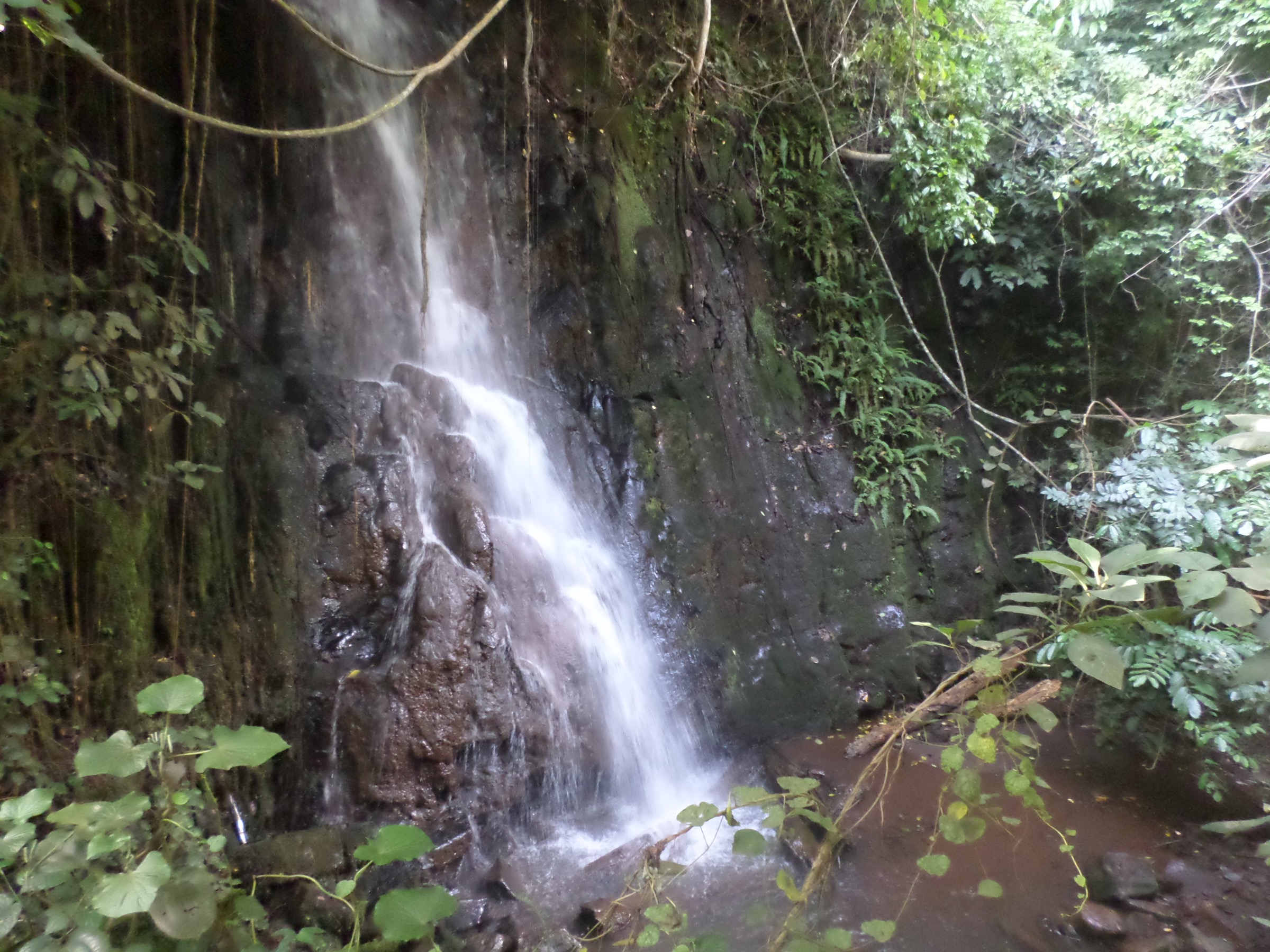
The route starts at Tello village in the Belel commune, around 50 km from Ngaoundéré at an altitude of about 1,532 m. The final 2 km approach to the falls requires fording the local river, which is straightforward in dry season but can be impassable in heavy rain. The fall itself drops around 40-50 m in two stages over a basalt table, with a recessed natural cave behind the main veil and a quiet pool surrounded by thick bush at the base.
The site is quieter than the more-visited Vina falls and is usable as a half-day from Ngaoundéré or as a stop on a longer Adamaoua tour with camping at the base.
Why it is essential
The Chutes de Tello are the main natural attraction of the Belel commune and add a second documented waterfall character to the catalogue, with a different geological setting from the Chutes de la Vina. The cave feature is the most distinctive geological signature of the Adamaoua waterfalls.
Equipment
Trail shoes, sun protection, 4×4 vehicle support for the ford, one to two litres of water, insect repellent, and basic camping kit if staying overnight.
Hazards and notes
- River ford in last 2 km can rise quickly after rain.
- Limited services beyond Tello village; carry food and water margins.
- Local security situation should still be confirmed before independent travel.
GPX / KML links
| Source | URL | Format / access | Reuse status |
|---|---|---|---|
| OpenStreetMap search — Tello Cameroon | openstreetmap.org | Map data / search | OSM data is ODbL; candidate geometry check only |
| Wikiloc search — Tello falls | wikiloc.com | Search | No reusable GPX identified |
External links
Missing data and follow-up work
- Trail metrics for Tchabal Mbabo, the Hosséré Vokré massif, Mont Ngaoundéré, and the Yade Massif — none of these have published distance, ascent, or maintained waymarking data; they remain research candidates.
- Chappal Waddi route file — no reusable GPX track was identified; route stats rely on a single published climbing protocol.
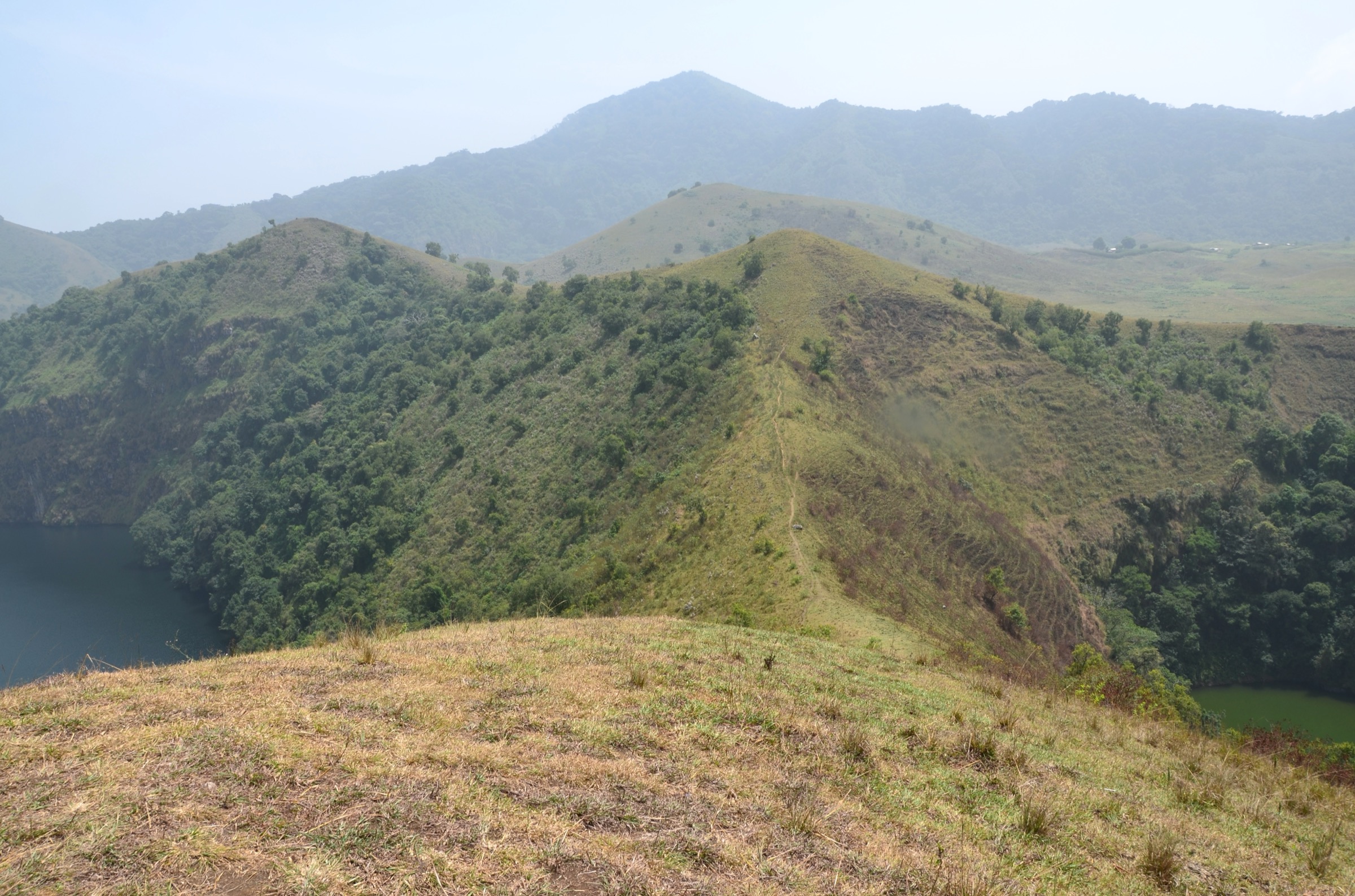
- Cover and feature photography — the cover image uses a Mambilla Plateau landscape; no licence-compatible photo of Lac Tison, the Chutes de la Vina, or the Chutes de Tello was found at adequate resolution in this pass.
- CAR-side coverage — the Central African Republic side of the Yade Massif and Bouar Plateau yielded no sourceable day-hike data and is not represented in the five-hike selection.
- Security and access — Cameroon’s North and Adamaoua regions are subject to active travel advisories; current advice should be checked at the time of any trip.
- Mambilla Plateau viewpoints — landscape character is well documented but no specific named day-hike line was identified beyond the Chappal Waddi protocol.
External links
| Source | URL |
|---|---|
| Wikipedia — Adamawa Plateau | en.wikipedia.org |
| Wikipedia — Chappal Waddi | en.wikipedia.org |
| Wikipedia — Gashaka-Gumti National Park | en.wikipedia.org |
| Wikipedia — Mambilla Plateau | en.wikipedia.org |
| Wikipedia — Tello, Cameroon | en.wikipedia.org |
| Wikipédia (FR) — Lac Tison | fr.wikipedia.org |
| Wikipédia (FR) — Chutes de la Vina | fr.wikipedia.org |
| Key Biodiversity Areas — Tchabal Mbabo | keybiodiversityareas.org |
| ERuDeF — Adamawa landscape | erudef.org |
| Ministry of Tourism, Cameroon — Lac Tison | mintoul.gov.cm |
| Wikiloc — Cameroon Adamaoua trails | wikiloc.com |