Regional overview
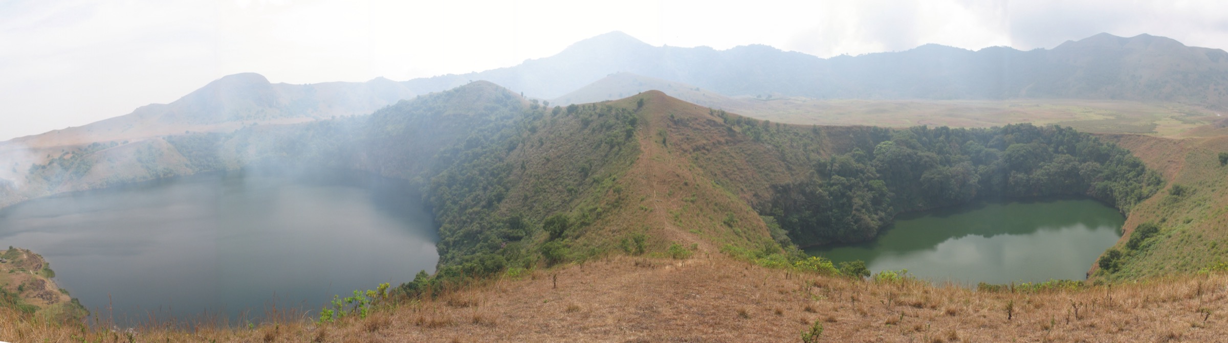
The Manengouba Mountains are a Pleistocene shield-and-stratovolcano massif on the central segment of the Cameroon Volcanic Line, straddling the boundary between the Littoral Region and the South-West Region of Cameroon. The summit reaches 2,396 m and the volcanic complex carries two summit calderas — the larger Eboga (also written Ebwo) caldera and the smaller Elengoum caldera — separated by a forested ridge. Within the Eboga caldera, at roughly 1,900 m, lie the two crater lakes long known locally as the male and female lakes and on most maps as the Lacs Jumeaux or Twin Lakes. Wikipedia gives a lake-surface elevation of about 1,900 m and a maximum depth of 5 m.
The hiking centres cluster around four nodes. Mbouroukou, on the eastern flank above Melong in the Moungo Division of the Littoral, is the standard trailhead for the foot ascent of the summit and the descent to the Ekom-Nkam waterfall on the Nkam River. Bangem, in the Kupe-Muanenguba Division on the western side, is the South-West gateway to the Twin Lakes via the Eboga caldera rim. Nkongsamba, the lowland railhead and old colonial town beneath the eastern flank, is the regional hub for road approaches. On the south-western side the massif joins the Bakossi Mountains, with Lake Edib and the cloud-forest catchments of the Bakossi National Park beyond the Jide valley divide.
The walking character is volcanic upland in tropical West Africa: lower slopes in coffee, cocoa, banana, and palm farms; mid-slopes in semi-deciduous and montane forest; and an open caldera-floor zone of short-grass savanna, scattered Mbororo cattle camps, and seasonal stream channels above roughly 1,900 m. The summit ridge between the two calderas carries a fringe of montane forest. Most routes are 5-22 km and feasible in a day, but the heat below 1,500 m, the steep, root-and-clay tread, and the lack of switchbacks on the standard summit path make the climbs feel longer than the distance suggests. The Manengouba grasslands stay cool year-round; cloud often caps the summit by mid-morning.
Cameroon’s bimodal rainfall regime applies, with a minor wet season from March to June, a main wet season from August to October, and a drier window from roughly December to February that is the practical hiking season. Independent off-track walking is not the local norm: guides are normally arranged at Mbouroukou for the eastern ascent and at Bangem for the Twin Lakes. Sensible precautions apply across the massif — heat and humidity in the forest belts, slippery clay tread in the rains, cloud and limited signage in the caldera, snakes in the lower forest, and limited drinking water above the cattle camps. The South-West Region has experienced security incidents in recent years; conditions can change quickly and require local confirmation before travel.
Selection rationale
The five hikes cover the main features and both flanks of the massif. The Mount Manengouba summit from Mbouroukou is the headline volcano climb on the Littoral side. The Twin Crater Lakes rim walk above Bangem is the iconic Cameroon Volcanic Line lake landscape, on the South-West side. The Eboga caldera grasslands traverse links the two halves and represents the rare montane savanna habitat. The Ekom-Nkam waterfall descent on the Nkam River pairs naturally with the summit day from Mbouroukou and captures the volcanic step-down to the Moungo lowlands. The Lake Edib forest walk represents the Bakossi flank, a smaller crater-lake landscape that is closely linked to the Manengouba volcanic complex.
Summary table
| # | Hike | Country | Route type | Distance | Gain | Max elevation | Difficulty |
|---|---|---|---|---|---|---|---|
| 1 | Mount Manengouba summit from Mbouroukou | Cameroon | Out-and-back | ~10 km | ~1,100 m | 2,396 m | Hard |
| 2 | Twin Crater Lakes rim walk from Bangem | Cameroon | Loop / out-and-back | ~8-12 km | ~400 m | ~2,000 m | Moderate |
| 3 | Eboga caldera grasslands traverse | Cameroon | Point-to-point / traverse | ~15-22 km | ~700 m | ~2,100 m | Hard |
| 4 | Ekom-Nkam waterfall descent on the Nkam | Cameroon | Out-and-back / descent | ~9 km | ~400 m | ~700 m | Moderate |
| 5 | Lake Edib forest walk on the Bakossi flank | Cameroon | Out-and-back | ~6-8 km | ~300 m | ~1,150 m | Moderate |
1. Mount Manengouba summit from Mbouroukou
Snapshot
Itinerary
The route leaves Mbouroukou village on the eastern flank, climbing a single sustained line through cocoa and banana farms and then into semi-deciduous and montane forest. Operator descriptions consistently note the absence of switchbacks; the path effectively follows the fall line up the volcano, gaining roughly 1,100 m to the upper grasslands. The forest belt gives way to short-grass caldera-rim country between roughly 1,900 m and the summit. The high point at 2,396 m sits on the ridge between the Eboga and Elengoum calderas; in clear weather views extend west to the Bakossi Mountains and north-east into the Bamboutos. Descent is by the same path. Trip reports usually treat the ascent as two to three hours from Mbouroukou and the round trip as a long single day, though many visitors break the walk with an overnight at the caldera floor.
Why it is essential
Mount Manengouba is the highest summit of the Manengouba massif and one of the headline volcanic summits of the Cameroon Volcanic Line between Mount Cameroon and the Bamboutos. The Mbouroukou foot ascent is the standard pilgrimage from the Littoral side and the cleanest single-day expression of the volcano’s height.
Equipment
- Sturdy trail shoes or light boots with grip on wet clay
- Sun protection and a hat for the upper grasslands
- Warm layer for the caldera rim; mornings are cool
- Light rain layer year-round
- 2-3 L water per person; no reliable resupply above the village
- Local guide arranged at Mbouroukou; no marked trail
Hazards and notes
- Sustained steep climb with no switchbacks; pace conservatively.
- Slippery clay and roots in or after rain.
- Cloud and reduced visibility likely by mid-morning on the summit ridge.
- Heat in the forest belt below 1,500 m.
- Snakes in the lower forest understorey.
- South-West Region security situation; confirm conditions locally before travel.
GPX / KML links
| Source | URL | Format / access | Reuse status |
|---|---|---|---|
| Wikiloc search — Mont Manengouba | wikiloc.com | Search page; user tracks | Wikiloc terms apply on selection; reuse unresolved |
| OpenStreetMap — Mount Manengouba | openstreetmap.org | Source map / search | OSM data is ODbL; geometry cross-check only |
External links
2. Twin Crater Lakes rim walk from Bangem

Snapshot
Itinerary
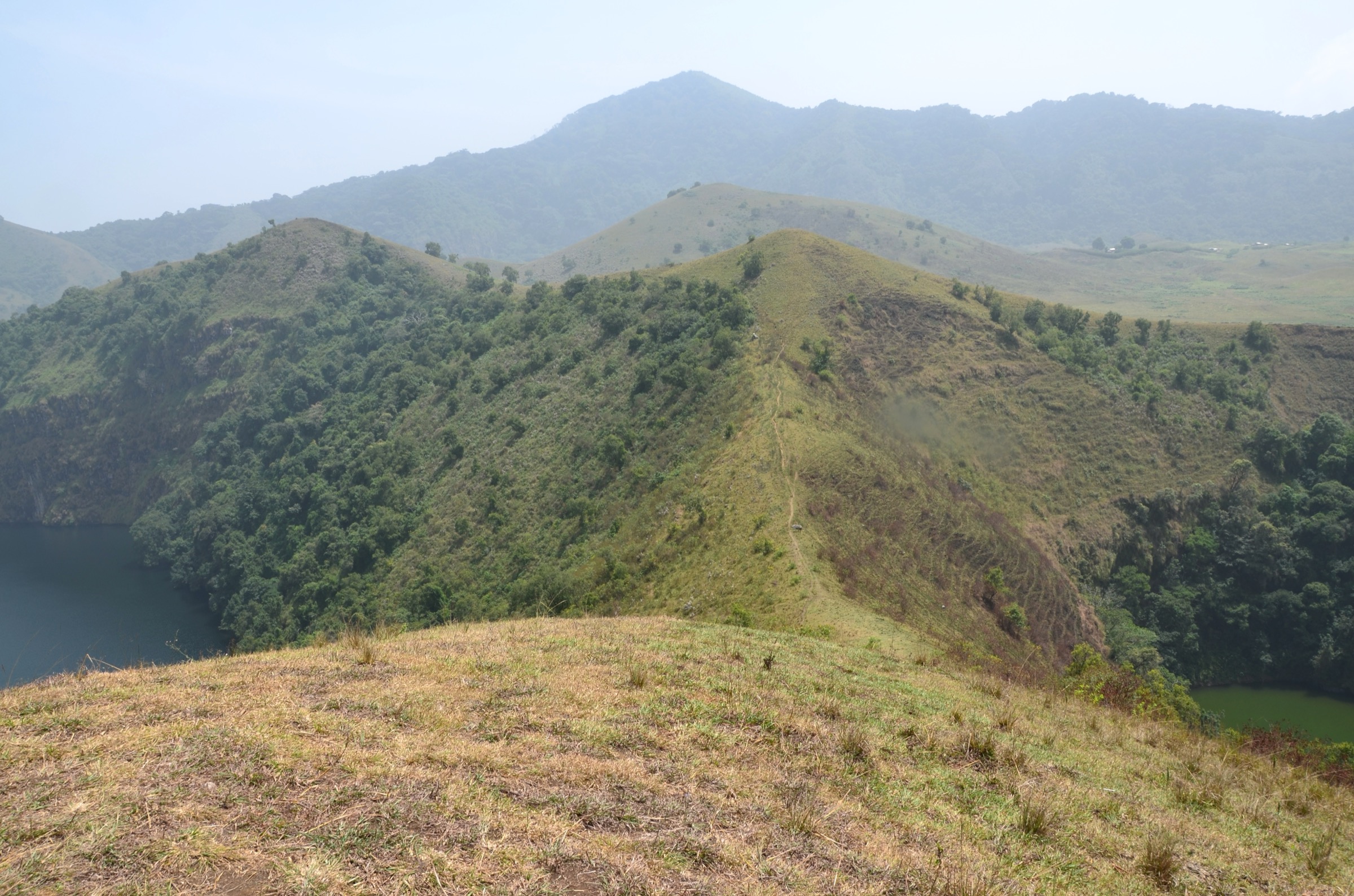
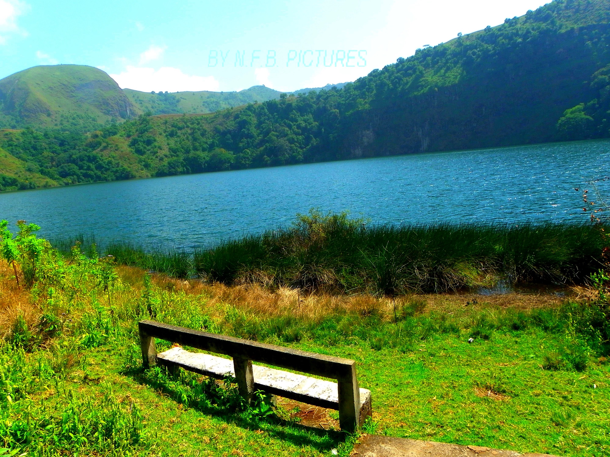
The standard South-West approach climbs from Bangem to the south-eastern lip of the Eboga caldera. From the rim a path drops to the larger female lake (Lake Aka), which is the blue-green crater-floor lake reached by a set of stepped descents and traditionally easier of the two. A second branch leaves the rim and descends to the smaller male lake (Lake Mbo), a darker, steeper-walled crater pool that sits a short distance to the south-west; this branch is shorter but steeper and the local convention is to visit it second. The complete walk combines the rim section above both lakes with two lake-floor visits and the return to Bangem; sources commonly cite a half-day for the round and a full day for a complete loop. Mbororo herders graze cattle on the rim grasslands and small workshops near the trail produce milk cheese.
Why it is essential
The Twin Crater Lakes are the most photographed feature of the Cameroon Volcanic Line between Mount Cameroon and the Bamboutos, and the only paired-caldera crater-lake landscape on the line. The rim walk above them is the headline non-technical hike on the South-West side of the Manengouba massif.
Equipment
- Trail shoes with grip on the descents
- Sun hat and sun protection on the open grasslands
- Light warm layer; the caldera rim is cool
- Light rain layer
- 2 L water per person
- Local guide arranged in Bangem; the rim path is unsigned
Hazards and notes
- Steep descent to the male lake; loose ground in places.
- Cloud often closes in by midday; arrive early for views.
- Cattle on the rim grasslands; close gates and avoid herds.
- Limited shade above the forest belt; sun and wind exposure.
- Cultural sensitivity: the lakes are sacred to the local Bakossi and Bamileke communities; respect any restrictions on swimming or noise.
- South-West Region security situation; confirm conditions locally before travel.
GPX / KML links
| Source | URL | Format / access | Reuse status |
|---|---|---|---|
| Wikiloc search — Lacs Jumeaux Manengouba | wikiloc.com | Search page; user tracks | Wikiloc terms apply on selection; reuse unresolved |
| OpenStreetMap — Bangem | openstreetmap.org | Source map / search | OSM data is ODbL; geometry cross-check only |
External links
3. Eboga caldera grasslands traverse
Snapshot
Itinerary
The traverse links the two principal trailheads of the massif and crosses the volcanic upland from one watershed to the other. Starting at Mbouroukou, the path climbs the eastern ascent line to the caldera grasslands, contours west across the Eboga caldera floor between roughly 1,900 m and 2,100 m, passes the two crater lakes, and descends the South-West side toward Bangem. The caldera floor is open short-grass savanna with seasonal stream channels, scattered Mbororo cattle camps, and small dairy workshops. The summit at 2,396 m can be added as a side-trip on the rim crossing for parties with the time. Operator and trip-report figures put the long-day version at roughly 22 km and around ten hours; most groups split the traverse with an overnight at the lakes.
Why it is essential
The grasslands traverse is the only routing that captures the full Manengouba landscape — village belt, forest, caldera grassland, crater lakes, and the link between the Littoral and South-West sides of the massif — in a single line.
Equipment
- Sturdy mountain hiking shoes or boots
- Trekking poles useful on the long descent
- Warm layer and gloves for the caldera rim
- Rain shell; weather changes quickly
- 3 L water per person; refills available at the lakes only after treatment
- Navigation backup; GPS or map
- Local guide essential; onward transport on the far side requires arrangement
Hazards and notes
- Long day with sustained ascent and descent.
- Cloud, mud, and unpredictable weather on the caldera floor.
- Route is unmarked in places; navigation can be hard in mist.
- Cattle on the grasslands; close gates.
- Limited shelter; carry a rain layer.
- Cultural sensitivity around the sacred lakes.
- South-West Region security situation; confirm conditions locally before travel.
GPX / KML links
| Source | URL | Format / access | Reuse status |
|---|---|---|---|
| Wikiloc search — Manengouba traverse | wikiloc.com | Search page; user tracks | Wikiloc terms apply on selection; reuse unresolved |
| OpenStreetMap — Eboga caldera area | openstreetmap.org | Source map / search | OSM data is ODbL; geometry cross-check only |
External links
4. Ekom-Nkam waterfall descent on the Nkam
Snapshot
Itinerary
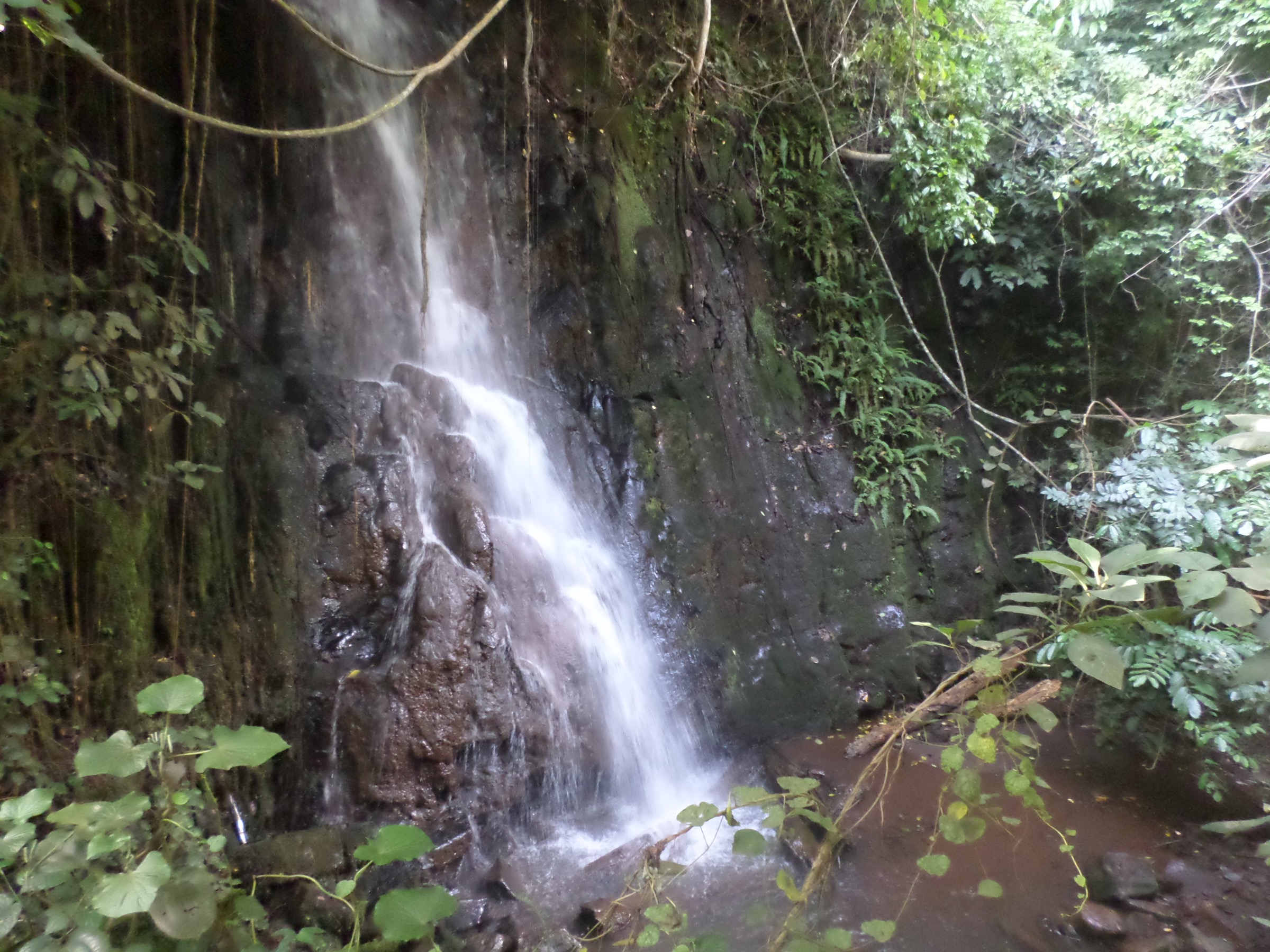
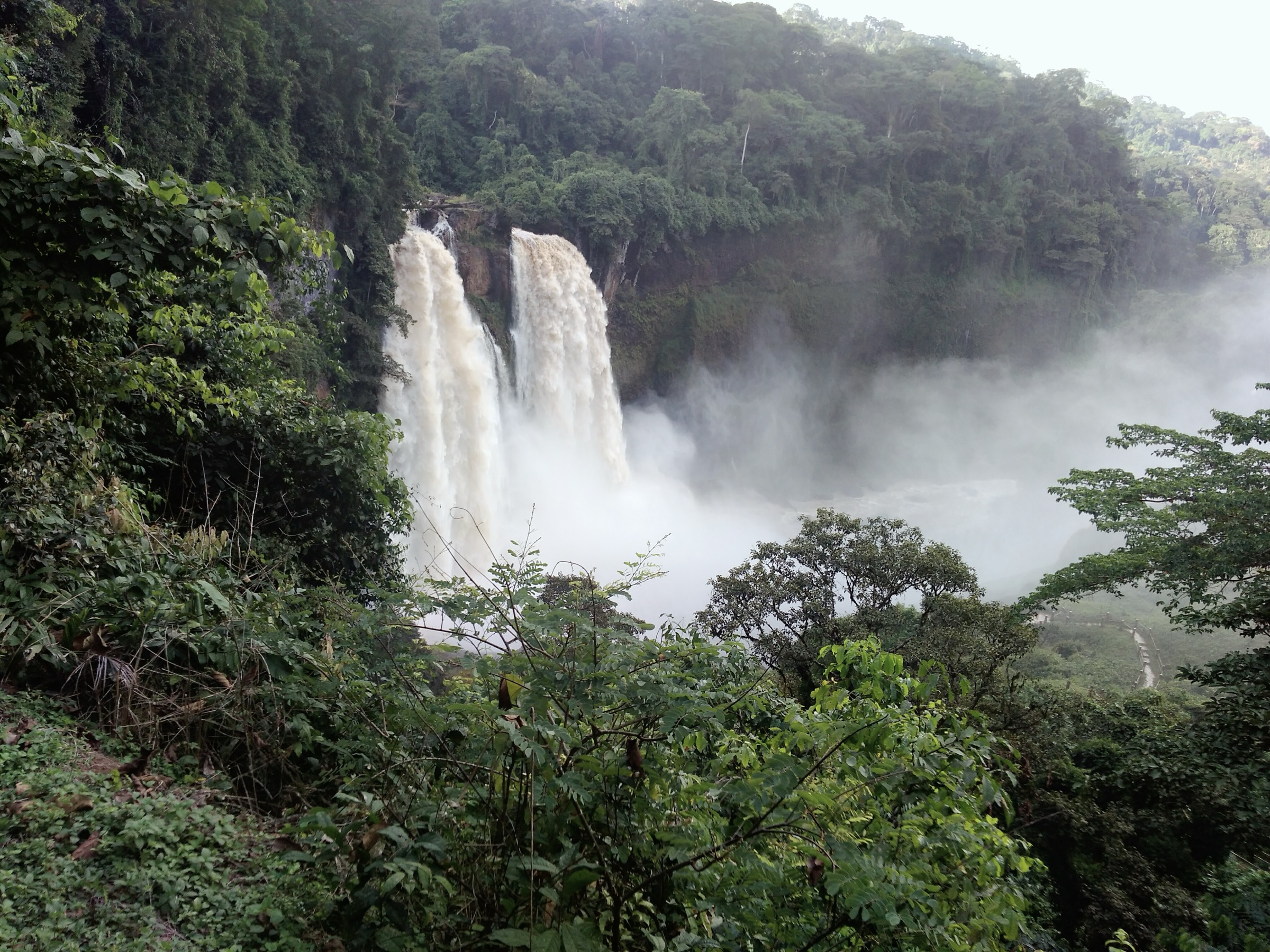
The Ekom-Nkam falls drop the Nkam River over an 80 m cliff in a forested amphitheatre on the lower south-eastern flank of the Manengouba massif, near Melong in the Moungo Division. The standard route descends from the road to a series of viewing platforms above, beside, and in front of the falls, with side branches to upstream pools and downstream river views. The setting features two main waterfalls — one perennial and one seasonal — and was the location of the Greystoke (1984) jungle scenes. The Manengouba-to-Ekom-Nkam linked itinerary, run by several Melong operators, descends from Mbouroukou on the eastern flank of the volcano to the upper Nkam and continues to the falls. A standalone foot trail of roughly 9 km has been reported from Nkongsamba.
Why it is essential
Ekom-Nkam is the headline waterfall of the Manengouba volcanic step-down and the natural day-trip pairing for the summit climb from Mbouroukou. The 80 m drop is one of the most photographed waterfalls in Cameroon and the most visited destination on the eastern flank of the massif.
Equipment
- Trail shoes with good grip; platforms and steps are slippery from spray
- Sun and rain protection
- Swimwear if planning to swim in downstream pools (check local advice)
- 1-2 L water for the round trip
- Insect repellent
- Site entrance fee paid at the gate; local guide useful
Hazards and notes
- Slippery platforms and rocks near the falls.
- Loose ground and cliff edges; respect the barriers.
- River level rises quickly in the rains.
- Heat and humidity in the gorge.
- Snakes and biting insects in the lower forest.
- Site fees and opening hours vary; confirm at the gate.
GPX / KML links
| Source | URL | Format / access | Reuse status |
|---|---|---|---|
| Wikiloc search — Ekom-Nkam | wikiloc.com | Search page; user tracks | Wikiloc terms apply on selection; reuse unresolved |
| OpenStreetMap — Ekom-Nkam Falls | openstreetmap.org | Source map / search | OSM data is ODbL; geometry cross-check only |
External links
5. Lake Edib forest walk on the Bakossi flank
Snapshot
Itinerary
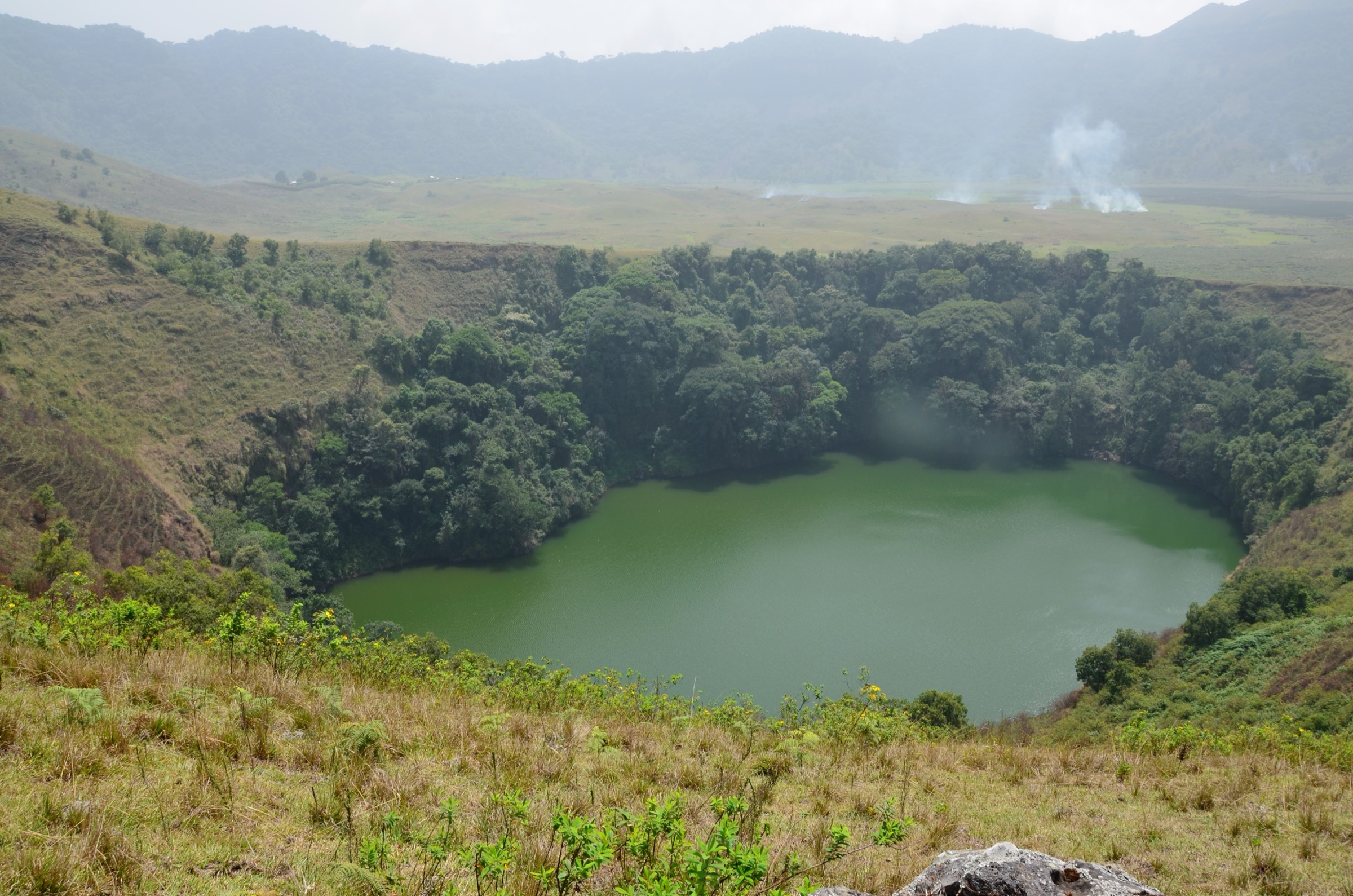
Lake Edib is a small crater lake in the Bakossi Mountains, on the western side of the Manengouba volcanic complex across the Jide valley, very close to Bakossi National Park. BirdLife and WWF describe a forested crater set in cloud forest, with cliffs around the rim and a swampy lake bed. The standard foot approach climbs from the village belt through coffee, banana, and cocoa farms into wet, broadleaf forest and contours to the rim, with a short descent to the lakeshore in dry weather. There is no published GPS trace; figures here are best-available approximations and the route is best treated as a half-day forest walk with a local guide. The walk is often combined with a visit to the Bakossi National Park boundary or the Kupe-Muanenguba ecotourism trails out of Nyasoso.
Why it is essential
Lake Edib represents the Bakossi flank of the Manengouba volcanic complex and the cloud-forest crater-lake landscape that lies just outside the headline Eboga caldera. It pairs the Manengouba massif with the Bakossi Mountains and rounds out the geographical span of the five hikes.
Equipment
- Trail shoes with grip on wet clay
- Light rain layer year-round
- 1-2 L water
- Insect repellent
- Local guide essential; the path is unsigned
- Cash for any community fees collected at the village
Hazards and notes
- Slippery clay tread in the cloud forest.
- Snakes in the forest understorey.
- Limited signage; navigation is hard without a guide.
- Wildlife disturbance in or near the Bakossi National Park; respect park rules.
- South-West Region security situation; confirm conditions locally before travel.
GPX / KML links
| Source | URL | Format / access | Reuse status |
|---|---|---|---|
| Wikiloc search — Lake Edib | wikiloc.com | Search page; user tracks | Wikiloc terms apply on selection; reuse unresolved |
| OpenStreetMap — Bakossi National Park | openstreetmap.org | Source map / search | OSM data is ODbL; geometry cross-check only |
External links
- BirdLife — Bakossi mountains IBA factsheet
- WWF Cameroon — Bakossi National Park
- Wikipedia — Bakossi Mountains
Missing data / follow-up work
- No officially published GPX/KML downloads were located for any of the five routes; Wikiloc and OpenStreetMap are used as geometry references only.
- Summit elevation: 2,396 m on Wikipedia, 2,411 m on several Wikimedia Commons descriptions and operator pages; the figure used here is the Wikipedia/peer-referenced one but requires authoritative survey confirmation.
- Distance and ascent figures for the Mount Manengouba summit climb, the Twin Crater Lakes rim walk, the caldera traverse, and the Lake Edib walk vary between operators and are best-available approximations; route-specific GPS tracks are needed to firm them up.
- Twin Lakes naming: “male” and “female” lakes are universally used locally, with Lake Mbo (male) and Lake Aka (female) reported on Wikipedia; the colour and access conventions vary between sources and require local confirmation.
- Lake Edib precise elevation, surface area, and trail distance were not located in a peer-reviewed source in this pass.
- Public transport: bus and shared-taxi services from Douala to Melong, Nkongsamba, and the South-West gateways operate but are not published on a fixed timetable; confirm locally.
- Cultural and protected-area access: the Lacs Jumeaux are sacred to the local Bakossi and Bamileke communities and the Bakossi National Park is a managed protected area; behaviour rules at both should be confirmed with local guides.
- South-West Region security: the South-West has experienced security incidents in recent years; conditions can change quickly and require current local confirmation before travel.
- No licence-compatible direct photograph of Lake Edib was located in this pass; the male crater lake image is used as a representative crater-lake landscape on the Manengouba complex, with a figcaption note.