Regional overview
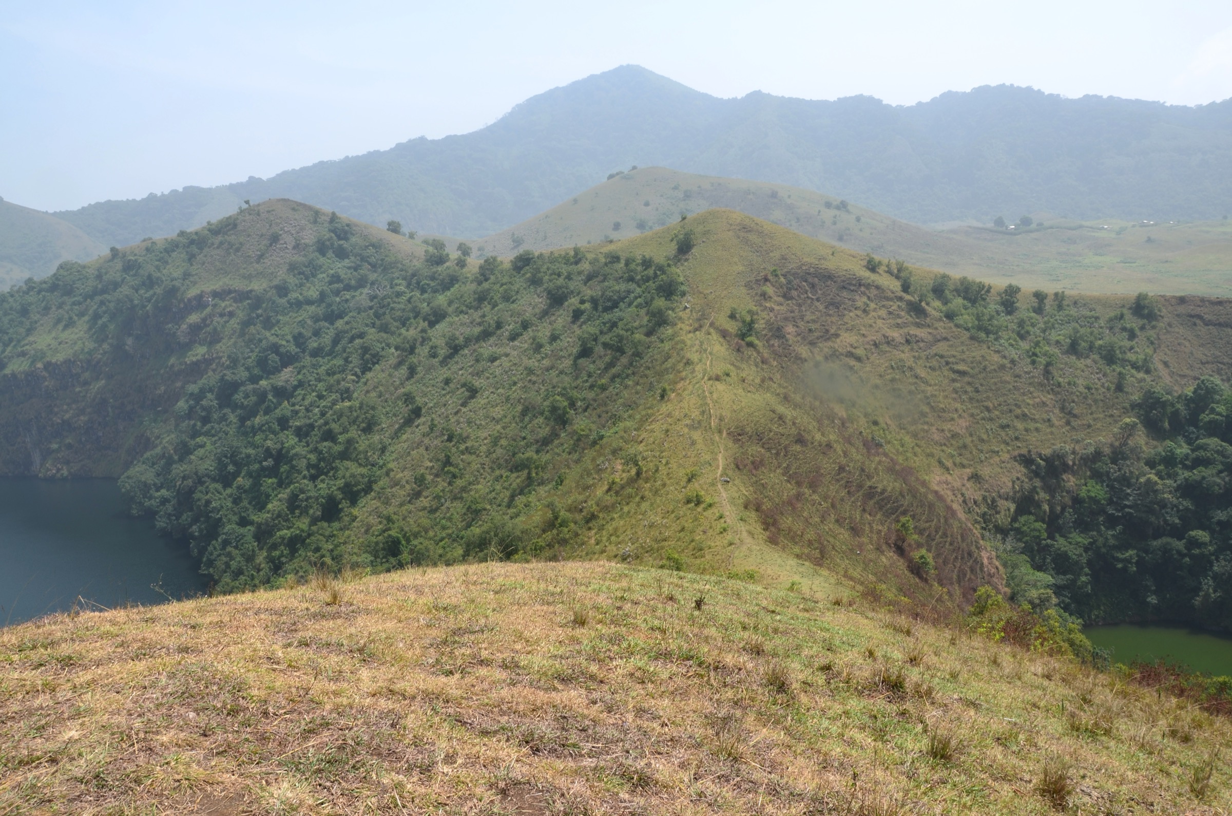
The Mandara Mountains are a volcanic upland that runs for roughly 190 km along the Nigeria–Cameroon border, from the Benue River in the south to a line just north-west of Maroua in the Sahel plain. The range belongs to the continental sector of the Cameroon Volcanic Line and is dominated by ancient granitic basement intruded by trachyte and rhyolite plugs, alkali basalt flows, and the eroded throats of long-dead volcanoes. The highest summit, Mount Oupay, reaches 1,494 m on the Cameroonian side; the most photographed feature is Rhumsiki Peak (Mchirgué), a 1,224 m basalt needle on the Kapsiki Plateau south of Mokolo. On the Nigerian side the range carries the Sukur Cultural Landscape, a terraced hilltop settlement at about 1,045 m that became Nigeria’s first UNESCO World Heritage site in 1999.
The walking terrain is open, hot, and exposed: terraced fields, dry-stone walls, sorghum and millet plots, scattered baobab and acacia, and steep volcanic plugs rising from a plateau around 900-1,100 m. Communities along the range include the Sukur (Adamawa, Nigeria), the Mafa around Mokolo and Mora, the Kapsiki and Psikye (Mogode, Rhumsiki, Sirakouti, Roumzou), and the Podokwo and Mandara groups further north. Many villages are still organised around traditional iron-smelting, terraced agriculture, and seasonal markets, and most walks here are as much cultural circuits between settlements as they are summit climbs.
The Mandara Mountains sit inside an active conflict region. The Boko Haram and ISWAP insurgency has affected travel across north-east Nigeria (Borno, Adamawa, Yobe) and Cameroon’s Far North Region since the early 2010s, including the Mandara border zone, and the Sukur Cultural Landscape was placed on UNESCO’s List of World Heritage in Danger in 2014 in response to insurgent activity in Adamawa State. Human Rights Watch, the International Crisis Group, and ReliefWeb have documented continuing attacks on civilians in the area around Mora and the Cameroonian Mandara foothills. Any travel to the range requires up-to-date checks with the UK FCDO travel advice, the US State Department, and the equivalent advice from a traveller’s home government, plus locally engaged guides and informed consent from village authorities. Several of the routes below are flagged as Candidate only for this reason — their walking lines are real, but on-the-ground access cannot be confirmed from open-source material alone.
Best conditions, where access permits, are the Sahel dry season from November to February. The Harmattan brings cool nights but heavy dust and reduced visibility through December and January. The rainy season from June to September floods the wadi crossings on the approach roads to Sukur, Mokolo, and Mora, and turns the upper terraces slippery. There is little reliable on-mountain water at any time of year, and food and fuel are not available between villages.
Selection rationale
The five hikes below cover the principal walking landscapes of the Mandara range across both sides of the border: the Sukur terraced hilltop and the Kapsiki volcanic plugs are the two iconic Mandara features, Mount Oupay is the range’s high point, and the Mora Massif and Kapsiki circuit options sample the wider Mafa and Kapsiki cultural landscape. The set deliberately spreads itself across Adamawa State in Nigeria and the Far North Region in Cameroon, mixes summit walks with village-to-village circuits, and is balanced so that no single route relies on a fragile or contested approach. All routes are listed at Candidate only or Partially verified because of the security situation; none can be claimed as currently safe without on-the-ground confirmation.
Summary table
| # | Hike | Country | Route type | Distance | Gain | Max elevation | Difficulty |
|---|---|---|---|---|---|---|---|
| 1 | Sukur Cultural Landscape walk | Nigeria | Loop / out-and-back | 7-9 km | ~250-350 m | ~1,045 m | Moderate |
| 2 | Rhumsiki Peak and Kapsiki villages walk | Cameroon | Loop / community circuit | 5-8 km | ~200-300 m | ~1,224 m | Easy to moderate |
| 3 | Mount Oupay ascent | Cameroon | Out-and-back | 8-10 km | ~600 m | 1,494 m | Moderate to hard |
| 4 | Mora Massif walk above Mora town | Cameroon | Loop / out-and-back | 6-10 km | ~300-500 m | ~950 m | Moderate |
| 5 | Kapsiki Plateau circuit Mogode-Sirakouti-Roumzou | Cameroon | Loop | 10-15 km | ~300 m | ~1,100 m | Moderate |
1. Sukur Cultural Landscape walk

Snapshot
Itinerary
From the road at the foot of the hill the route follows the historic stone-paved processional path, climbing past terraced fields of sorghum and millet, dry-stone retaining walls, and ceremonial granaries to the hilltop settlement at roughly 1,045 m. The summit village is organised around Hidi’s Palace, the dry-stone residence and shrine complex of the Hidi (chief), with surrounding ceramic shrines, iron-smelting sites, and grain-store clusters. Walkers descend by the same path or loop down a parallel terraced route. The full landscape is a UNESCO World Heritage cultural landscape and movement between zones is normally guided.
Why it is essential
Sukur is the defining cultural walk of the Mandara range — the only UNESCO World Heritage site in the massif and one of the most complete surviving examples of a terraced hilltop kingdom in West Africa. The processional path, Hidi’s Palace, and the layered terraces give a clear reading of the Sukur settlement system that no other Mandara route can match.
Equipment
- Sturdy walking shoes for stone-paved tread
- Sun hat and high-SPF sun protection
- Minimum 2-3 L water per person; no reliable water on the hill
- Cash for site and community fees
- Local guide arranged through the National Commission for Museums and Monuments or the community
- Modest dress for visiting the palace and shrines
Hazards and notes
- The wider Adamawa / Borno border region has been affected by the Boko Haram and ISWAP insurgency since the early 2010s; the Sukur Cultural Landscape was added to UNESCO’s List of World Heritage in Danger in 2014. Check current UK FCDO and US State Department travel advice before any visit.
- Approach roads from Mubi and Madagali pass through areas of variable security.
- Strong sun and very limited shade on the open terraces.
- Stone-paved path can be slippery in the wet season.
- Visits to Hidi’s Palace and shrines require community consent.
GPX / KML links
| Source | URL | Format / access | Reuse status |
|---|---|---|---|
| OpenStreetMap — Sukur search | openstreetmap.org | Source map / search | OSM data is ODbL; geometry cross-check only |
| Wikiloc search — Sukur | wikiloc.com | Search page; user tracks | Wikiloc terms apply on selection; reuse unresolved |
External links
- UNESCO World Heritage Centre — Sukur Cultural Landscape
- Wikipedia — Sukur
- UK FCDO travel advice — Nigeria
- US State Department — Nigeria travel advisory
2. Rhumsiki Peak and Kapsiki villages walk

Snapshot
Itinerary
The Rhumsiki community walk starts in the village and circles the base of the iconic basalt needle of Mchirgué (Rhumsiki Peak), a 1,224 m volcanic plug rising from the Kapsiki Plateau at about 900 m. The standard loop runs through Kapsiki compounds with their stone enclosures, granaries, and traditional crab-divining spaces, drops to the wadi crossings west of the peak, and climbs to a viewpoint shoulder where the surrounding plugs and the Nigeria border ridge open up. The actual summit climb of the basalt needle is technical and not part of the walking route. Guides from the village association lead all sections.
Why it is essential
Rhumsiki is the postcard image of the Mandara Mountains and the single most accessible introduction to the Kapsiki volcanic-plug landscape — a “lunar” plain of trachyte and basalt needles that has few parallels in West or Central Africa. The community-led loop combines the geology with the cultural framework of the Kapsiki and is the standard non-technical way to experience the area.
Equipment
- Sturdy walking shoes or light boots
- Sun hat and high-SPF sun protection
- 2 L water per person; very limited refill points
- Cash for village fee, guide, and crab-diviner visit if arranged
- Light wind layer for early-morning starts
- Modest dress for compound visits
Hazards and notes
- Cameroon’s Far North Region has been affected by the Boko Haram insurgency spilling across the Mandara border from Nigeria; ICG and HRW have documented attacks on civilians in the wider region. Verify the current security picture before travel.
- Strong sun and exposed plateau with little shade.
- Rocky tread; rolled ankles common.
- Visits to compounds and divination spaces require consent and a small fee.
- Border-zone position: do not cross into Nigeria without proper documents.
GPX / KML links
| Source | URL | Format / access | Reuse status |
|---|---|---|---|
| Wikiloc search — Rhumsiki | wikiloc.com | Search page; user tracks | Wikiloc terms apply on selection; reuse unresolved |
| OpenStreetMap — Rhumsiki search | openstreetmap.org | Source map / search | OSM data is ODbL; geometry cross-check only |
External links
- Wikipedia — Rhumsiki
- Wikipedia — Mogode
- UK FCDO travel advice — Cameroon
- US State Department — Cameroon travel advisory
3. Mount Oupay ascent

Snapshot
Itinerary
Mount Oupay is the highest summit of the Mandara range at 1,494 m and stands above the plateau between Mokolo and Mogode on the Cameroonian side. The standard approach climbs from one of the surrounding Mafa or Kapsiki villages on a network of unmarked goat paths and terrace edges, gaining roughly 600 m to the rocky summit ridge. The summit gives a broad view across the Mandara plateau, the Kapsiki plugs to the south, and the Sahel plain to the north and east. Return is by the same line. Walkers should treat the route as unmarked and depend on a local guide for line and water.
Why it is essential
Oupay is the range high point — the only Mandara summit above 1,400 m and the natural counterpart to the Kapsiki and Sukur cultural walks. It is the route that puts the rest of the massif into perspective.
Equipment
- Sturdy boots with good grip for loose rock
- Sun hat and high-SPF sun protection
- 3 L water per person; nothing reliable on the route
- Local guide essential for line and security
- Light wind layer for the summit ridge
- Trekking poles helpful on the descent
Hazards and notes
- Far North Region security situation: cross-check current UK FCDO and US State Department advice; the area between Mokolo and the Nigerian border has been affected by the Boko Haram insurgency.
- No waymarking; route relies on a local guide.
- No reliable water on the climb.
- Strong sun and dust, especially during the Harmattan.
- Wildlife encounters with snakes possible in the rainy-season margins.
- Photography of military or police installations is prohibited.
GPX / KML links
| Source | URL | Format / access | Reuse status |
|---|---|---|---|
| PeakVisor — Mont Oupay | peakvisor.com | Peak reference page | No GPX track confirmed |
| OpenStreetMap — Oupay search | openstreetmap.org | Source map / search | OSM data is ODbL; geometry cross-check only |
External links
4. Mora Massif walk above Mora town

Snapshot
Itinerary
The Massif de Mora is a granitic outlier rising about 954 m above the Sahel plain immediately west of Mora town. A traditional walking line climbs through Mafa villages on the lower terraces to a ridge that looks east across the plain toward Lake Chad and west into the Mandara core. As the wider Mora area has been directly affected by the insurgency in recent years, the Ziver-Oudjila ridge walk between two well-documented Mafa villages above Mokolo, further south, is offered as a substitute: a 6-10 km traverse along a high terraced ridge linking the conical compounds and granaries of Ziver and Oudjila with sweeping views over the Mandara plateau. Both options should be treated as guided cultural walks rather than open mountain routes.
Why it is essential
The Mafa cultural landscape of conical thatched compounds, dry-stone terraces, and ridge-top settlements is one of the most distinctive of the Mandara, and the Mora or Ziver-Oudjila ridges are the standard way to walk through it. The route complements the Sukur and Kapsiki options by sampling the Mafa side of the massif.
Equipment
- Sturdy walking shoes
- Sun hat and high-SPF sun protection
- 2-3 L water per person; village water is not normally drinkable untreated
- Cash for village fees and guide
- Light wind layer for the ridge
- Modest dress and a willingness to greet compound heads
Hazards and notes
- The Mora area in particular has been hit by Boko Haram attacks on civilians; ICG and HRW have documented continuing incidents. Do not assume the route is accessible without current local advice and government clearance.
- Photography of military positions or checkpoints is prohibited.
- Rocky terraces and uneven steps.
- Strong sun and limited shade.
- Village visits require consent and small fees.
GPX / KML links
| Source | URL | Format / access | Reuse status |
|---|---|---|---|
| OpenStreetMap — Mora search | openstreetmap.org | Source map / search | OSM data is ODbL; geometry cross-check only |
| Wikiloc search — Oudjila / Ziver | wikiloc.com | Search page; user tracks | Wikiloc terms apply on selection; reuse unresolved |
External links
- Wikipedia — Mora, Cameroon
- International Crisis Group — Cameroon Far North
- Human Rights Watch — Cameroon Boko Haram attacks
- UK FCDO travel advice — Cameroon
5. Kapsiki Plateau circuit Mogode-Sirakouti-Roumzou

Snapshot
Itinerary
The Kapsiki Plateau circuit links three Psikye villages — Mogode, Sirakouti, and Roumzou — on the higher plateau south of Mokolo, away from the main Rhumsiki tourist focus. The route crosses open sorghum and millet fields, drops into wadi crossings under isolated volcanic plugs, and visits compounds with their characteristic dry-stone enclosures and rock-cut grain stores. Distances and lines vary with the season and which villages are receiving visitors; the figure of 10-15 km covers a standard one-day loop. Guides are arranged in Mogode through the commune office or the Kapsiki cultural association.
Why it is essential
The circuit gives a quieter, more rural reading of the Kapsiki landscape than the Rhumsiki community walk, with the same volcanic-plug scenery and a closer look at everyday agricultural life. It is the standard “longer walking” Kapsiki option for visitors who want more than the Rhumsiki loop.
Equipment
- Sturdy walking shoes
- Sun hat and high-SPF sun protection
- 3 L water per person; very limited refill points
- Cash for village fees and guide
- Snacks; no food sold between villages
- Modest dress
Hazards and notes
- Cameroon’s Far North Region carries an active security warning; check UK FCDO and US State Department advice and clear the route with local authorities.
- Long exposed sections with no shade.
- Wadi crossings can flood unexpectedly in shoulder seasons.
- Photography in compounds requires consent.
- Border-zone position with Nigeria; carry passport and any required permits.
GPX / KML links
| Source | URL | Format / access | Reuse status |
|---|---|---|---|
| OpenStreetMap — Kapsiki plateau search | openstreetmap.org | Source map / search | OSM data is ODbL; geometry cross-check only |
| Wikiloc search — Mogode | wikiloc.com | Search page; user tracks | Wikiloc terms apply on selection; reuse unresolved |
External links
- Wikipedia — Mogode
- Wikipedia — Mandara Mountains
- UK FCDO travel advice — Cameroon
- US State Department — Cameroon travel advisory
Missing data / follow-up work
- All five routes are listed as Candidate only or Partially verified because of the active insurgency in north-east Nigeria and Cameroon’s Far North Region; none can be claimed as currently safe without on-the-ground confirmation.
- No officially published GPX/KML downloads were located for any of the five routes; OpenStreetMap and Wikiloc are used as geometry references only.
- Photograph attributions were re-checked against the Wikimedia Commons File: pages and corrected after the initial draft; the two “Mandara Mountains - panoramio” images carry CC BY 3.0 (not CC BY-SA), credited to the original Panoramio uploader (vavaulegrandbleu).
- Mount Oupay trailhead options, route line, and current access conditions are not documented in any open-source guidebook material located in this pass; a guided field visit is needed to firm up distances, gain, and the practical start village.
- The Mora Massif route in particular cannot be confirmed as accessible to visitors; the Ziver-Oudjila alternative is offered for the same reason but is also subject to the wider Far North security picture.
- Community fees, guide arrangements, and Sukur site access procedures change frequently; confirm current rates and access policy with the Cameroonian and Nigerian heritage authorities before travel.